Bridge Statistics for Vandalia, Michigan (MI)
Condition, Traffic, Stress, Structural Evaluation, Project Costs
- National Bridge Inventory (NBI) Statistics
- 20Number of bridges
- 197ft / 60.4mTotal length
- $300,000Total costs
- 35,639Total average daily traffic
- 2,250Total average daily truck traffic
- 47,889Total future (year 1977) average daily traffic
- National Bridge Inventory (NBI) Registered Bridges for Vandalia
- No street view available for this location
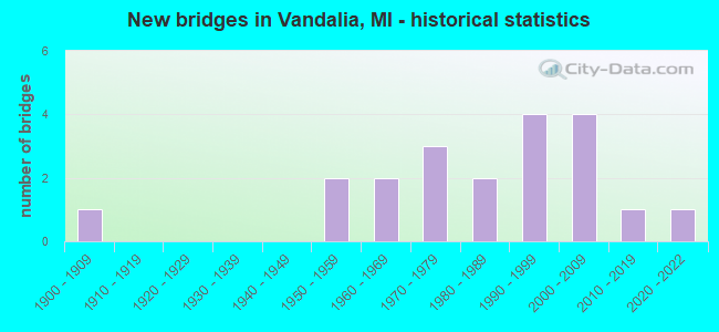
- New bridges - historical statistics
- 11900-1909
- 21950-1959
- 21960-1969
- 31970-1979
- 21980-1989
- 41990-1999
- 42000-2009
- 12010-2019
- 12020-2022

- Reconstructed bridges - Historical Statistics
- 11960-1969
- 01970-1979
- 01980-1989
- 01990-1999
- 12000-2009


- Bridge Condition - Deck
- 23.5%Very good
- 35.3%Good
- 23.5%Satisfactory
- 17.6%Fair

- Bridge Condition - Superstructure
- 11.8%Very good
- 35.3%Good
- 35.3%Satisfactory
- 11.8%Fair
- 5.9%Poor

- Bridge Condition - Substructure
- 23.5%Very good
- 41.2%Good
- 17.6%Satisfactory
- 11.8%Fair
- 5.9%Poor

- Bridge Condition - Channel
- 15.8%Very good
- 42.1%Good
- 26.3%Satisfactory
- 15.8%Fair

- Bridge Condition - Culverts
- 66.7%Satisfactory
- 33.3%Critical
Find on map >> Show street view
Structure Number: 227, Location: JUST N OF 106TH AVE (Lat: 42.462861, Lng: -85.973908), Route carried "on" structure: County highway , Year Built: 1969, Status: Posted for load, Structure Length: 0.97m (3.18ft), Average Daily Traffic: 392 (year 2002), Truck Traffic: 7%, Average Future Daily Traffic: 784 (year 2022), Design Load: HS 20, Features Intersected: SWAN CREEK, Facility Carried by Structure: 44TH STREET
Minimum Vertical Clearance: 30.48m (100.00ft), Kilometerpoint: 4.864, Lanes on structure: 2, Owner: County Highway Agency, Approaching Roadway Width: 9.1m (29.9ft), Material/Design: Wood or Timber, Design/Construction: Slab, Number Of Spans In Main Unit: 1, Length of Maximum Span: 9.7m (31.8ft), Curb-To-Curb Width: 8.5m (27.9ft), Out-to-Out Width: 8.9m (29.2ft)
Condition: Deck: Fair, Superstructure: Satisfactory, Substructure: Satisfactory, Channel: Satisfactory, Operating Rating: 34.0 metric tons, Method Used To Determine Operating Rating: Allowable Stress (AS) rating reported by rating factor (RF) method using MS18 loading, Inventory Rating: 23.0 metric tons, Method Used To Determine Inventory Rating: Allowable Stress (AS) rating reported by rating factor (RF) method using MS18 loading, Structural Evaluation: Equal to present minimum criteria, Deck Geometry: Equal to present minimum criteria, Waterway Adequacy: Equal to present minimum criteria, Approach Roadway Alignment: Equal to present desirable criteria, Bridge Posting: Required (Relationship of Operating Rating to Maximum Legal Load: 20.0 - 29.9% below), Designated Inspection Frequency: Every 24 months, Inspection Date: April 2021, Deck Structure Type: Wood or Timber, Wearing Surface/Protective System: Wearing Surface: Bituminous
Find on map >> Show street view
Structure Number: 228, Location: CLYDE TWP SEC 7-18 (Lat: 42.564392, Lng: -86.113733), Route carried "on" structure: County highway , Year Built: 1993, Status: Open, Structure Length: 1.09m (3.58ft), Average Daily Traffic: 53 (year 2002), Truck Traffic: 7%, Average Future Daily Traffic: 106 (year 2022), Design Load: HS 20, Features Intersected: LEVERIDGE DRAIN, Facility Carried by Structure: 120TH AVENUE
Minimum Vertical Clearance: 30.48m (100.00ft), Kilometerpoint: 8.533, Lanes on structure: 2, Owner: County Highway Agency, Approaching Roadway Width: 9.8m (32.2ft), Material/Design: Prestressed concrete, Design/Construction: Box Beam or Girders - Multiple, Number Of Spans In Main Unit: 1, Length of Maximum Span: 10.9m (35.8ft), Curb-To-Curb Width: 9.1m (29.9ft), Out-to-Out Width: 9.4m (30.8ft)
Condition: Deck: Good, Superstructure: Satisfactory, Substructure: Satisfactory, Channel: Good, Operating Rating: 62.5 metric tons, Method Used To Determine Operating Rating: Load Factor (LF) rating reported by rating factor (RF) method using MS18 loading, Inventory Rating: 37.6 metric tons, Method Used To Determine Inventory Rating: Load Factor (LF) rating reported by rating factor (RF) method using MS18 loading, Structural Evaluation: Equal to present minimum criteria, Deck Geometry: Better than present minimum criteria, Waterway Adequacy: Equal to present desirable criteria, Approach Roadway Alignment: Equal to present desirable criteria, Designated Inspection Frequency: Every 24 months, Inspection Date: May 2021, Deck Structure Type: Concrete Precast Panels, Wearing Surface/Protective System: Wearing Surface: Bituminous, Membrane: Other
Find on map >> Show street view
Structure Number: 229, Location: DORR TWP SEC 31 (Lat: 42.681564, Lng: -85.766144), Route carried "on" structure: County highway , Year Built: 1993, Status: Open, Structure Length: 2.74m (8.99ft), Average Daily Traffic: 170 (year 2020), Truck Traffic: 7%, Average Future Daily Traffic: 253 (year 2040), Design Load: HS 20, Features Intersected: RABBIT RIVER, Facility Carried by Structure: 136TH AVENUE
Minimum Vertical Clearance: 30.48m (100.00ft), Kilometerpoint: 2.786, Lanes on structure: 2, Owner: County Highway Agency, Approaching Roadway Width: 9.8m (32.2ft), Material/Design: Prestressed concrete, Design/Construction: Box Beam or Girders - Multiple, Number Of Spans In Main Unit: 1, Length of Maximum Span: 27.0m (88.6ft), Curb-To-Curb Width: 9.1m (29.9ft), Out-to-Out Width: 9.5m (31.2ft)
Condition: Deck: Very good, Superstructure: Good, Substructure: Satisfactory, Channel: Good, Operating Rating: 61.9 metric tons, Method Used To Determine Operating Rating: Load Factor (LF) rating reported by rating factor (RF) method using MS18 loading, Inventory Rating: 37.3 metric tons, Method Used To Determine Inventory Rating: Load Factor (LF) rating reported by rating factor (RF) method using MS18 loading, Structural Evaluation: Equal to present minimum criteria, Deck Geometry: Equal to present minimum criteria, Waterway Adequacy: Equal to present desirable criteria, Approach Roadway Alignment: Equal to present desirable criteria, Designated Inspection Frequency: Every 24 months, Inspection Date: May 2021, Deck Structure Type: Concrete Precast Panels, Wearing Surface/Protective System: Wearing Surface: Bituminous, Membrane: Preformed Fabric
Find on map >> Show street view
Structure Number: 231, Location: APPROX 3/8MI E OF 18TH ST (Lat: 42.710544, Lng: -85.714328), Route carried "on" structure: County highway , Year Built: 1974, Status: Open, Structure Length: 0.78m (2.56ft), Average Daily Traffic: 279 (year 2002), Truck Traffic: 7%, Average Future Daily Traffic: 558 (year 2022), Design Load: H 20, Features Intersected: RED RUN DRAIN, Facility Carried by Structure: 140TH AVE
Minimum Vertical Clearance: 30.48m (100.00ft), Kilometerpoint: 3.061, Lanes on structure: 2, Owner: County Highway Agency, Approaching Roadway Width: 7.6m (24.9ft), Skew: 2 degrees, Material/Design: Steel, Design/Construction: Culvert, Number Of Spans In Main Unit: 2, Length of Maximum Span: 3.2m (10.5ft)
Condition: Channel: Fair, Culverts: Satisfactory, Operating Rating: 76.1 metric tons, Method Used To Determine Operating Rating: Load Factor (LF) rating reported by rating factor (RF) method using MS18 loading, Inventory Rating: 45.7 metric tons, Method Used To Determine Inventory Rating: Load Factor (LF) rating reported by rating factor (RF) method using MS18 loading, Structural Evaluation: Equal to present minimum criteria, Waterway Adequacy: Equal to present minimum criteria, Approach Roadway Alignment: Equal to present desirable criteria, Designated Inspection Frequency: Every 24 months, Inspection Date: April 2021
Find on map >> Show street view
Structure Number: 232, Location: APPROX 1/8MI W OF 16TH ST (Lat: 42.710475, Lng: -85.703533), Route carried "on" structure: County highway , Year Built: 1974, Status: Posted for load, Structure Length: 0.93m (3.05ft), Average Daily Traffic: 279 (year 2002), Truck Traffic: 7%, Average Future Daily Traffic: 558 (year 2022), Design Load: H 20, Features Intersected: RED RUN DRAIN, Facility Carried by Structure: 140TH AVE
Minimum Vertical Clearance: 30.48m (100.00ft), Kilometerpoint: 3.945, Lanes on structure: 2, Owner: County Highway Agency, Approaching Roadway Width: 7.3m (24.0ft), Skew: 4 degrees, Material/Design: Steel, Design/Construction: Culvert, Number Of Spans In Main Unit: 2, Length of Maximum Span: 3.9m (12.8ft)
Condition: Channel: Satisfactory, Culverts: Critical, Operating Rating: 36.9 metric tons, Method Used To Determine Operating Rating: Load Factor (LF) rating reported by rating factor (RF) method using MS18 loading, Inventory Rating: 22.0 metric tons, Method Used To Determine Inventory Rating: Load Factor (LF) rating reported by rating factor (RF) method using MS18 loading, Structural Evaluation: High priority of replacement, Waterway Adequacy: Equal to present minimum criteria, Approach Roadway Alignment: Equal to present desirable criteria, Bridge Posting: Required (Relationship of Operating Rating to Maximum Legal Load: > 39.9% below), Designated Inspection Frequency: Every 6 months, Inspection Date: October 2021
Find on map >> Show street view
Structure Number: 348, Location: 15 MI W OF ALPENA (Lat: 45.082669, Lng: -83.757506), Route carried "on" structure: County highway 423, Year Built: 1984, Status: Open, Structure Length: 3.29m (10.79ft), Average Daily Traffic: 200 (year 2010), Average Future Daily Traffic: 250 (year 2030), Design Load: HS 20, Features Intersected: THUNDER BAY RIVER, Facility Carried by Structure: SALINA ROAD
Minimum Vertical Clearance: 30.48m (100.00ft), Kilometerpoint: 2.538, Lanes on structure: 2, Owner: County Highway Agency, Approaching Roadway Width: 9.8m (32.2ft), Material/Design: Prestressed concrete, Design/Construction: Box Beam or Girders - Multiple, Number Of Spans In Main Unit: 3, Length of Maximum Span: 10.9m (35.8ft), Curb-To-Curb Width: 9.4m (30.8ft), Out-to-Out Width: 9.5m (31.2ft)
Condition: Deck: Satisfactory, Superstructure: Satisfactory, Substructure: Fair, Channel: Satisfactory, Operating Rating: 34.5 metric tons, Method Used To Determine Operating Rating: Load Factor (LF), Inventory Rating: 32.7 metric tons, Method Used To Determine Inventory Rating: Load Factor (LF), Structural Evaluation: Somewhat better than minimum adequacy, Deck Geometry: Equal to present minimum criteria, Waterway Adequacy: Better than present minimum criteria, Approach Roadway Alignment: Equal to present desirable criteria, Designated Inspection Frequency: Every 24 months, Inspection Date: August 2020, Deck Structure Type: Concrete Precast Panels, Wearing Surface/Protective System: Wearing Surface: Bituminous, Deck Protection: Epoxy Coated Reinforcing
Find on map >> Show street view
Structure Number: 349, Location: AT CITY LIMITS ALPENA (Lat: 45.067325, Lng: -83.472011), Route carried "on" structure: County highway 2025, Year Built: 2021, Status: Open, Structure Length: 9.91m (32.51ft), Average Daily Traffic: 15,000 (year 2020), Truck Traffic: 8%, Average Future Daily Traffic: 19,500 (year 2040), Design Load: Greater than HL93, Features Intersected: THUNDER BAY RIVER, Facility Carried by Structure: BAGLEY STREET
Minimum Vertical Clearance: 30.48m (100.00ft), Kilometerpoint: 4.392, Lanes on structure: 2, Owner: County Highway Agency, Approaching Roadway Width: 16.2m (53.1ft), Skew: 3 degrees, Material/Design: Prestressed concrete, Design/Construction: Stringer/Multi-beam, Number Of Spans In Main Unit: 4, Length of Maximum Span: 25.3m (83.0ft), Curb or Sidewalk Widths: Left: 2.4m (7.9ft), Right: 4.3m (14.1ft), Curb-To-Curb Width: 15.2m (49.9ft), Out-to-Out Width: 24.0m (78.7ft)
Condition: Deck: Fair, Superstructure: Fair, Substructure: Good, Channel: Very good, Deck Geometry: Superior to present desirable criteria, Waterway Adequacy: Better than present minimum criteria, Approach Roadway Alignment: Equal to present desirable criteria, Designated Inspection Frequency: Every 24 months, Inspection Date: August 2020, Deck Structure Type: Concrete Cast-file-Place, Wearing Surface/Protective System: Wearing Surface: Monolithic Concrete, Deck Protection: Epoxy Coated Reinforcing
Find on map >> Show street view
Structure Number: 666, Location: S LTS OF AUBURN (Lat: 43.596772, Lng: -84.069453), Route carried "on" structure: County highway , Year Built: 2015, Status: Open, Structure Length: 5.25m (17.22ft), Average Daily Traffic: 2,120 (year 1983), Average Future Daily Traffic: 2,120 (year 1977), Design Load: Greater than HL93, Features Intersected: US-10, Facility Carried by Structure: NINE MILE RD
Minimum Vertical Clearance: 30.48m (100.00ft), Kilometerpoint: 3.230, Lanes on structure: 2, Lanes under structure: 4, Owner: State Highway Agency, Approaching Roadway Width: 9.8m (32.2ft), Material/Design: Prestressed concrete, Design/Construction: Stringer/Multi-beam, Number Of Spans In Main Unit: 2, Length of Maximum Span: 25.5m (83.7ft), Curb-To-Curb Width: 9.8m (32.2ft), Out-to-Out Width: 10.5m (34.4ft)
Condition: Deck: Good, Superstructure: Very good, Substructure: Very good, Operating Rating: 45.7 metric tons, Method Used To Determine Operating Rating: Load and Resistance Factor Rating (LRFR) rating reported by rating factor(RF) method using HL-93 loadings, Inventory Rating: 35.3 metric tons, Method Used To Determine Inventory Rating: Load and Resistance Factor Rating (LRFR) rating reported by rating factor(RF) method using HL-93 loadings, Structural Evaluation: Equal to present desirable criteria, Deck Geometry: Meets minimum limits, Underclear: Equal to present minimum criteria, Approach Roadway Alignment: Somewhat better than minimum adequacy, Designated Inspection Frequency: Every 24 months, Inspection Date: August 2021, Deck Structure Type: Concrete Cast-file-Place, Wearing Surface/Protective System: Wearing Surface: Monolithic Concrete, Deck Protection: Epoxy Coated Reinforcing
Find on map >> Show street view
Structure Number: 1385, Location: BURLINGTON (Lat: 42.105283, Lng: -85.060417), Route carried "on" structure: County highway , Year Built: 2001, Status: Open, Structure Length: 2.79m (9.15ft), Average Daily Traffic: 193 (year 1994), Average Future Daily Traffic: 360 (year 2024), Design Load: HS 20, Features Intersected: ST JOSEPH RIVER, Facility Carried by Structure: 12 MILE ROAD
Minimum Vertical Clearance: 30.48m (100.00ft), Kilometerpoint: 3.602, Lanes on structure: 2, Owner: County Highway Agency, Approaching Roadway Width: 9.0m (29.5ft), Material/Design: Prestressed concrete, Design/Construction: Box Beam or Girders - Multiple, Number Of Spans In Main Unit: 1, Length of Maximum Span: 27.9m (91.5ft), Curb-To-Curb Width: 9.0m (29.5ft), Out-to-Out Width: 9.7m (31.8ft)
Condition: Deck: Good, Superstructure: Good, Substructure: Good, Channel: Good, Operating Rating: 84.0 metric tons, Method Used To Determine Operating Rating: Load Factor (LF), Inventory Rating: 50.0 metric tons, Method Used To Determine Inventory Rating: Load Factor (LF), Structural Evaluation: Better than present minimum criteria, Waterway Adequacy: Better than present minimum criteria, Approach Roadway Alignment: Equal to present desirable criteria, Designated Inspection Frequency: Every 24 months, Inspection Date: September 2020, Deck Structure Type: Concrete Cast-file-Place, Wearing Surface/Protective System: Wearing Surface: Monolithic Concrete, Deck Protection: Epoxy Coated Reinforcing
Find on map >> Show street view
Structure Number: 145, Location: 3 MI E OF M-62 (Lat: 41.866550, Lng: -85.953011), Route carried "on" structure: County highway , Year Built: 2006, Status: Open, Structure Length: 1.71m (5.61ft), Average Daily Traffic: 40 (year 2019), Truck Traffic: 3%, Average Future Daily Traffic: 50 (year 2039), Design Load: HS 20, Features Intersected: CHRISTIANN CREEK, Facility Carried by Structure: CHAIN LAKE STREET
Minimum Vertical Clearance: 30.48m (100.00ft), Kilometerpoint: 0.605, Lanes on structure: 2, Owner: County Highway Agency, Approaching Roadway Width: 9.1m (29.9ft), Material/Design: Prestressed concrete, Design/Construction: Box Beam or Girders - Multiple, Number Of Spans In Main Unit: 1, Length of Maximum Span: 16.5m (54.1ft), Curb-To-Curb Width: 9.1m (29.9ft), Out-to-Out Width: 9.5m (31.2ft)
Condition: Deck: Very good, Superstructure: Satisfactory, Substructure: Very good, Channel: Satisfactory, Operating Rating: 97.2 metric tons, Method Used To Determine Operating Rating: Load Factor (LF) rating reported by rating factor (RF) method using MS18 loading, Inventory Rating: 67.1 metric tons, Method Used To Determine Inventory Rating: Load Factor (LF) rating reported by rating factor (RF) method using MS18 loading, Structural Evaluation: Equal to present minimum criteria, Deck Geometry: Better than present minimum criteria, Waterway Adequacy: Equal to present desirable criteria, Approach Roadway Alignment: Somewhat better than minimum adequacy, Length Of Structure Improvement: 1.50m (4.92ft), Designated Inspection Frequency: Every 24 months, Inspection Date: October 2020, Bridge Improvement Cost: $148,000, Roadway Improvement Cost: $20,000, Total Project Cost: $168,000, Deck Structure Type: Concrete Cast-file-Place, Wearing Surface/Protective System: Wearing Surface: Epoxy Overlay, Deck Protection: Epoxy Coated Reinforcing
Find on map >> Show street view
Structure Number: 3527, Location: SEC.1CHANDLERTWP. (Lat: 43.935247, Lng: -83.126611), Route carried "on" structure: County highway 3266, Year Built: 1993, Status: Open, Structure Length: 2.74m (8.99ft), Average Daily Traffic: 1,520 (year 2009), Average Future Daily Traffic: 2,745 (year 2029), Design Load: HS 20, Features Intersected: PINNEBOG RIVER, Facility Carried by Structure: KINDE ROAD
Minimum Vertical Clearance: 30.48m (100.00ft), Kilometerpoint: 9.758, Lanes on structure: 2, Owner: County Highway Agency, Approaching Roadway Width: 10.4m (34.1ft), Material/Design: Prestressed concrete, Design/Construction: Tee Beam, Number Of Spans In Main Unit: 3, Length of Maximum Span: 8.5m (27.9ft), Curb-To-Curb Width: 10.5m (34.4ft), Out-to-Out Width: 11.4m (37.4ft)
Condition: Deck: Satisfactory, Superstructure: Satisfactory, Substructure: Good, Channel: Good, Operating Rating: 67.2 metric tons, Method Used To Determine Operating Rating: Load Factor (LF), Inventory Rating: 40.2 metric tons, Method Used To Determine Inventory Rating: Load Factor (LF), Structural Evaluation: Equal to present minimum criteria, Deck Geometry: Equal to present minimum criteria, Waterway Adequacy: Better than present minimum criteria, Approach Roadway Alignment: Equal to present desirable criteria, Designated Inspection Frequency: Every 24 months, Inspection Date: August 2021, Deck Structure Type: Concrete Precast Panels, Wearing Surface/Protective System: Wearing Surface: Bituminous, Membrane: Preformed Fabric
Find on map >> Show street view
Structure Number: 3894, Location: 0.6 M E & 1.9 M N OF HOLT (Lat: 42.666092, Lng: -84.503467), Route carried "on" structure: County highway , Year Built: 2005, Status: Open, Structure Length: 2.83m (9.28ft), Average Daily Traffic: 1,135 (year 2019), Truck Traffic: 2%, Average Future Daily Traffic: 1,390 (year 2039), Design Load: HS 20, Features Intersected: SYCAMORE CREEK, Facility Carried by Structure: PINE TREE ROAD
Minimum Vertical Clearance: 30.48m (100.00ft), Kilometerpoint: 2.068, Lanes on structure: 2, Owner: County Highway Agency, Approaching Roadway Width: 11.0m (36.1ft), Material/Design: Prestressed concrete, Design/Construction: Box Beam or Girders - Multiple, Number Of Spans In Main Unit: 1, Length of Maximum Span: 27.6m (90.6ft), Curb-To-Curb Width: 10.7m (35.1ft), Out-to-Out Width: 11.4m (37.4ft)
Condition: Deck: Good, Superstructure: Good, Substructure: Very good, Channel: Satisfactory, Operating Rating: 92.8 metric tons, Method Used To Determine Operating Rating: Load Factor (LF), Inventory Rating: 39.2 metric tons, Method Used To Determine Inventory Rating: Load Factor (LF), Structural Evaluation: Better than present minimum criteria, Deck Geometry: Equal to present minimum criteria, Waterway Adequacy: Better than present minimum criteria, Approach Roadway Alignment: Equal to present desirable criteria, Designated Inspection Frequency: Every 24 months, Inspection Date: May 2021, Deck Structure Type: Concrete Cast-file-Place, Wearing Surface/Protective System: Wearing Surface: Integral Concrete, Deck Protection: Epoxy Coated Reinforcing
Find on map >> Show street view
Structure Number: 5701, Location: 0.1 MI WEST OF SORBY HWY (Lat: 41.964317, Lng: -84.346539), Route carried "on" structure: County highway , Year Built: 1973, Year Reconstructed: 2009, Status: Open, Structure Length: 1.12m (3.67ft), Average Daily Traffic: 419 (year 2011), Truck Traffic: 1%, Average Future Daily Traffic: 1,000 (year 2031), Design Load: HS 20+Mod, Features Intersected: FITTS CREEK, Facility Carried by Structure: MANITOU RD
Minimum Vertical Clearance: 30.48m (100.00ft), Kilometerpoint: 1.466, Lanes on structure: 2, Owner: County Highway Agency, Approaching Roadway Width: 7.9m (25.9ft), Material/Design: Wood or Timber, Design/Construction: Slab, Number Of Spans In Main Unit: 1, Length of Maximum Span: 10.6m (34.8ft), Curb-To-Curb Width: 7.3m (24.0ft), Out-to-Out Width: 7.3m (24.0ft)
Condition: Deck: Very good, Superstructure: Very good, Substructure: Good, Channel: Very good, Inventory Rating: 79.5 metric tons, Method Used To Determine Inventory Rating: Allowable Stress (AS), Structural Evaluation: Better than present minimum criteria, Deck Geometry: Meets minimum limits, Waterway Adequacy: Equal to present minimum criteria, Approach Roadway Alignment: Equal to present desirable criteria, Length Of Structure Improvement: 1.13m (3.71ft), Designated Inspection Frequency: Every 24 months, Inspection Date: January 2022, Bridge Improvement Cost: $92,000, Roadway Improvement Cost: $82,000, Deck Structure Type: Wood or Timber, Wearing Surface/Protective System: Wearing Surface: Bituminous, Deck Protection: Other
Find on map >> Show street view
Structure Number: 6658, Location: 2.0 MI N OF US-10 (Lat: 43.982203, Lng: -86.418914), Route carried "on" structure: County highway 2032, Year Built: 1988, Status: Open, Structure Length: 14.72m (48.29ft), Average Daily Traffic: 6,000 (year 1997), Truck Traffic: 5%, Average Future Daily Traffic: 8,000 (year 2017), Design Load: HS 20+Mod, Features Intersected: LINCOLN RIVER, Facility Carried by Structure: JEBAVY ROAD
Minimum Vertical Clearance: 30.48m (100.00ft), Kilometerpoint: 0.423, Lanes on structure: 2, Owner: County Highway Agency, Approaching Roadway Width: 12.2m (40.0ft), Material/Design: Prestressed concrete continuous, Design/Construction: Stringer/Multi-beam, Number Of Spans In Main Unit: 6, Length of Maximum Span: 24.7m (81.0ft), Curb-To-Curb Width: 9.7m (31.8ft), Out-to-Out Width: 10.4m (34.1ft)
Condition: Deck: Satisfactory, Superstructure: Fair, Substructure: Good, Channel: Good, Operating Rating: 55.7 metric tons, Method Used To Determine Operating Rating: Allowable Stress (AS), Inventory Rating: 32.7 metric tons, Method Used To Determine Inventory Rating: Allowable Stress (AS), Structural Evaluation: Somewhat better than minimum adequacy, Deck Geometry: Meets minimum limits, Waterway Adequacy: Superior to present desirable criteria, Approach Roadway Alignment: Equal to present desirable criteria, Designated Inspection Frequency: Every 24 months, Inspection Date: August 2020, Deck Structure Type: Concrete Cast-file-Place, Wearing Surface/Protective System: Wearing Surface: Integral Concrete, Deck Protection: Epoxy Coated Reinforcing
Find on map >> Show street view
Structure Number: 6659, Location: 1 MI N OF OCEANA CO LINE (Lat: 43.831333, Lng: -86.425936), Route carried "on" structure: County highway 5317, Year Built: 1900, Year Reconstructed: 1972, Status: Open, Structure Length: 0.97m (3.18ft), Average Daily Traffic: 1,000 (year 1997), Truck Traffic: 10%, Average Future Daily Traffic: 1,500 (year 2017), Design Load: HS 20+Mod, Features Intersected: BASS LAKE OUTLET, Facility Carried by Structure: LAKESHORE DRIVE
Minimum Vertical Clearance: 30.48m (100.00ft), Kilometerpoint: 0.378, Lanes on structure: 2, Owner: County Highway Agency, Approaching Roadway Width: 9.1m (29.9ft), Material/Design: Prestressed concrete, Design/Construction: Box Beam or Girders - Multiple, Number Of Spans In Main Unit: 1, Length of Maximum Span: 9.1m (29.9ft), Curb-To-Curb Width: 7.3m (24.0ft), Out-to-Out Width: 7.3m (24.0ft)
Condition: Deck: Good, Superstructure: Good, Substructure: Good, Channel: Good, Operating Rating: 50.9 metric tons, Method Used To Determine Operating Rating: Allowable Stress (AS), Inventory Rating: 37.3 metric tons, Method Used To Determine Inventory Rating: Allowable Stress (AS), Structural Evaluation: Better than present minimum criteria, Deck Geometry: Meets minimum limits, Waterway Adequacy: Equal to present desirable criteria, Approach Roadway Alignment: Meets minimum limits, Designated Inspection Frequency: Every 24 months, Inspection Date: August 2020, Deck Structure Type: Concrete Precast Panels, Wearing Surface/Protective System: Wearing Surface: Bituminous
Find on map >> Show street view
Structure Number: 6661, Location: 1.6 MI N OF TOWN LINE RD (Lat: 44.102903, Lng: -86.330397), Route carried "on" structure: County highway 5333, Year Built: 1966, Status: Open, Structure Length: 1.95m (6.40ft), Average Daily Traffic: 2,000 (year 1997), Truck Traffic: 10%, Average Future Daily Traffic: 2,500 (year 2017), Design Load: HS 20+Mod, Features Intersected: BIG SAUBLE RIVER, Facility Carried by Structure: QUARTERLINE ROAD
Minimum Vertical Clearance: 30.48m (100.00ft), Kilometerpoint: 5.960, Lanes on structure: 2, Owner: County Highway Agency, Approaching Roadway Width: 12.2m (40.0ft), Material/Design: Wood or Timber, Design/Construction: Stringer/Multi-beam, Number Of Spans In Main Unit: 2, Length of Maximum Span: 9.7m (31.8ft), Curb-To-Curb Width: 9.1m (29.9ft), Out-to-Out Width: 9.1m (29.9ft)
Condition: Deck: Satisfactory, Superstructure: Satisfactory, Substructure: Fair, Channel: Good, Operating Rating: 44.5 metric tons, Method Used To Determine Operating Rating: Allowable Stress (AS), Inventory Rating: 30.9 metric tons, Method Used To Determine Inventory Rating: Allowable Stress (AS), Structural Evaluation: Somewhat better than minimum adequacy, Deck Geometry: Somewhat better than minimum adequacy, Waterway Adequacy: Equal to present desirable criteria, Approach Roadway Alignment: Better than present minimum criteria, Designated Inspection Frequency: Every 24 months, Inspection Date: August 2020, Deck Structure Type: Wood or Timber, Wearing Surface/Protective System: Wearing Surface: Bituminous
Find on map >> Show street view
Structure Number: 6942, Location: .15 M S OF SALT RIVER ROA (Lat: 43.573208, Lng: -84.588203), Route carried "on" structure: County highway 5605, Year Built: 1957, Status: Posted for load, Structure Length: 2.01m (6.59ft), Average Daily Traffic: 1,104 (year 1999), Truck Traffic: 7%, Average Future Daily Traffic: 1,640 (year 2019), Design Load: HS 20+Mod, Features Intersected: SALTRIVER, Facility Carried by Structure: COLEMAN ROAD
Minimum Vertical Clearance: 30.48m (100.00ft), Kilometerpoint: 11.903, Lanes on structure: 2, Owner: County Highway Agency, Approaching Roadway Width: 8.2m (26.9ft), Material/Design: Steel, Design/Construction: Stringer/Multi-beam, Number Of Spans In Main Unit: 1, Length of Maximum Span: 19.8m (65.0ft), Curb-To-Curb Width: 7.3m (24.0ft), Out-to-Out Width: 8.8m (28.9ft)
Condition: Deck: Good, Superstructure: Good, Substructure: Good, Channel: Fair, Operating Rating: 53.1 metric tons, Method Used To Determine Operating Rating: Load Factor (LF) rating reported by rating factor (RF) method using MS18 loading, Inventory Rating: 31.8 metric tons, Method Used To Determine Inventory Rating: Load Factor (LF) rating reported by rating factor (RF) method using MS18 loading, Structural Evaluation: Better than present minimum criteria, Deck Geometry: Meets minimum limits, Waterway Adequacy: Equal to present desirable criteria, Approach Roadway Alignment: Equal to present desirable criteria, Bridge Posting: Required (Relationship of Operating Rating to Maximum Legal Load: 0.1 - 9.9% below), Designated Inspection Frequency: Every 24 months, Inspection Date: September 2021, Deck Structure Type: Concrete Cast-file-Place, Wearing Surface/Protective System: Wearing Surface: Bituminous
Find on map >> Show street view
Structure Number: 7038, Location: SECTION 1 T21N R7W (Lat: 44.242728, Lng: -85.094078), Route carried "on" structure: County highway 5724, Year Built: 1958, Status: Posted for load, Structure Length: 2.19m (7.19ft), Average Daily Traffic: 1,316 (year 2019), Truck Traffic: 20%, Average Future Daily Traffic: 1,600 (year 2039), Design Load: HS 20+Mod, Features Intersected: CLAM RIVER, Facility Carried by Structure: FORWARD ROAD
Minimum Vertical Clearance: 30.48m (100.00ft), Kilometerpoint: 8.770, Lanes on structure: 2, Owner: County Highway Agency, Approaching Roadway Width: 10.1m (33.1ft), Material/Design: Prestressed concrete, Design/Construction: Box Beam or Girders - Multiple, Number Of Spans In Main Unit: 2, Length of Maximum Span: 10.3m (33.8ft), Curb-To-Curb Width: 7.9m (25.9ft), Out-to-Out Width: 8.2m (26.9ft)
Condition: Deck: Fair, Superstructure: Poor, Substructure: Poor, Channel: Good, Operating Rating: 37.3 metric tons, Method Used To Determine Operating Rating: Load Factor (LF) rating reported by rating factor (RF) method using MS18 loading, Inventory Rating: 22.4 metric tons, Method Used To Determine Inventory Rating: Load Factor (LF) rating reported by rating factor (RF) method using MS18 loading, Structural Evaluation: Meets minimum limits, Deck Geometry: Meets minimum limits, Waterway Adequacy: Equal to present desirable criteria, Approach Roadway Alignment: Equal to present desirable criteria, Bridge Posting: Required (Relationship of Operating Rating to Maximum Legal Load: 20.0 - 29.9% below), Length Of Structure Improvement: 2.20m (7.22ft), Designated Inspection Frequency: Every 12 months, Inspection Date: May 2021, Bridge Improvement Cost: $122,000, Total Project Cost: $132,000, Deck Structure Type: Concrete Cast-file-Place, Wearing Surface/Protective System: Wearing Surface: Bituminous
Find on map >> Show street view
Structure Number: 13267, Location: 0.25MI N OF WILLIAMSVILLE (Lat: 41.875014, Lng: -85.933558), Route carried "on" structure: County highway , Year Built: 1998, Status: Open, Structure Length: 0.74m (2.43ft), Average Daily Traffic: 2,276 (year 2009), Average Future Daily Traffic: 2,800 (year 2029), Design Load: HS 20, Features Intersected: CHRISTIANA CREEK, Facility Carried by Structure: CALVIN CENTER ROAD
Minimum Vertical Clearance: 30.48m (100.00ft), Kilometerpoint: 11.737, Lanes on structure: 2, Owner: County Highway Agency, Approaching Roadway Width: 9.1m (29.9ft), Material/Design: Steel, Design/Construction: Culvert, Number Of Spans In Main Unit: 3, Length of Maximum Span: 2.1m (6.9ft), Curb-To-Curb Width: 9.1m (29.9ft), Out-to-Out Width: 14.7m (48.2ft)
Condition: Channel: Fair, Culverts: Satisfactory, Operating Rating: 53.1 metric tons, Method Used To Determine Operating Rating: Load Factor (LF) rating reported by rating factor (RF) method using MS18 loading, Inventory Rating: 31.8 metric tons, Method Used To Determine Inventory Rating: Load Factor (LF) rating reported by rating factor (RF) method using MS18 loading, Structural Evaluation: Equal to present minimum criteria, Deck Geometry: Meets minimum limits, Waterway Adequacy: Equal to present minimum criteria, Approach Roadway Alignment: Equal to present desirable criteria, Designated Inspection Frequency: Every 24 months, Inspection Date: October 2020
Find on map >> Show street view
Structure Number: 13268, Location: 0.25 MI E OF CHAIN LK ST (Lat: 41.871114, Lng: -85.949625), Route carried "on" structure: County highway , Year Built: 2008, Status: Open, Structure Length: 1.71m (5.61ft), Average Daily Traffic: 143 (year 2019), Truck Traffic: 3%, Average Future Daily Traffic: 175 (year 2039), Design Load: HS 25 or greater, Features Intersected: CHRISTIANA CREEK, Facility Carried by Structure: NORTHROP STREET
Minimum Vertical Clearance: 30.48m (100.00ft), Kilometerpoint: 0.568, Lanes on structure: 2, Owner: County Highway Agency, Approaching Roadway Width: 9.1m (29.9ft), Skew: 1 degrees, Material/Design: Prestressed concrete, Design/Construction: Box Beam or Girders - Multiple, Number Of Spans In Main Unit: 1, Length of Maximum Span: 15.8m (51.8ft), Curb-To-Curb Width: 9.1m (29.9ft), Out-to-Out Width: 9.6m (31.5ft)
Condition: Deck: Very good, Superstructure: Good, Substructure: Very good, Channel: Very good, Operating Rating: 97.2 metric tons, Method Used To Determine Operating Rating: Load Factor (LF) rating reported by rating factor (RF) method using MS18 loading, Inventory Rating: 61.2 metric tons, Method Used To Determine Inventory Rating: Load Factor (LF) rating reported by rating factor (RF) method using MS18 loading, Structural Evaluation: Better than present minimum criteria, Deck Geometry: Equal to present minimum criteria, Waterway Adequacy: Equal to present desirable criteria, Approach Roadway Alignment: Better than present minimum criteria, Designated Inspection Frequency: Every 24 months, Inspection Date: October 2020, Deck Structure Type: Concrete Cast-file-Place, Wearing Surface/Protective System: Wearing Surface: Epoxy Overlay, Deck Protection: Epoxy Coated Reinforcing