Bridge Statistics for Valparaiso, Florida (FL)
Condition, Traffic, Stress, Structural Evaluation, Project Costs
- National Bridge Inventory (NBI) Statistics
- 14Number of bridges
- 456ft / 139mTotal length
- $53,000Total costs
- 150,210Total average daily traffic
- 8,007Total average daily truck traffic
- National Bridge Inventory (NBI) Registered Bridges for Valparaiso
- No street view available for this location
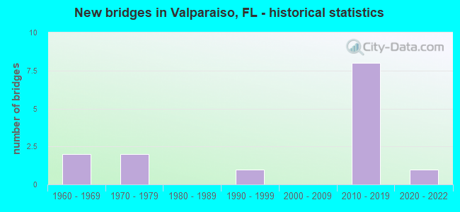
- New bridges - historical statistics
- 21960-1969
- 21970-1979
- 11990-1999
- 82010-2019
- 12020-2022


- Bridge Condition - Deck
- 11.1%Very good
- 55.6%Good
- 22.2%Satisfactory
- 11.1%Serious

- Bridge Condition - Superstructure
- 11.1%Very good
- 77.8%Good
- 11.1%Serious

- Bridge Condition - Substructure
- 22.2%Very good
- 44.4%Good
- 33.3%Satisfactory

- Bridge Condition - Channel
- 14.3%Excellent
- 28.6%Very good
- 42.9%Good
- 14.3%Satisfactory
Find on map >> Show street view
Structure Number: 570019, Location: 0.6mi. South of SR190 (Lat: 30.503150, Lng: -86.494081), Route carried "on" structure: State highway 397, Year Built: 1962, Year Reconstructed: 2021, Status: Open, Structure Length: 20.85m (68.41ft), Average Daily Traffic: 9,100 (year 2020), Truck Traffic: 4%, Average Future Daily Traffic: 15,788 (year 2042), Design Load: HL 93, Features Intersected: Toms Bayou
Minimum Vertical Clearance: 30+ m (98+ ft), Kilometerpoint: 1.333, Lanes on structure: 2, Base Highway Network: Yes, Owner: State Highway Agency, Approaching Roadway Width: 8.5m (27.9ft), Material/Design: Prestressed concrete, Design/Construction: Stringer/Multi-beam, Number Of Spans In Main Unit: 19, Length of Maximum Span: 11.0m (36.1ft), Curb or Sidewalk Widths: Left: 1.2m (3.9ft), Right: 0.0m, Curb-To-Curb Width: 8.5m (27.9ft), Out-to-Out Width: 15.6m (51.2ft)
Condition: Deck: Satisfactory, Superstructure: Good, Substructure: Satisfactory, Channel: Excellent, Operating Rating: 49.4 metric tons, Method Used To Determine Operating Rating: Load and Resistance Factor (LRFR), Inventory Rating: 38.1 metric tons, Method Used To Determine Inventory Rating: Load and Resistance Factor (LRFR), Structural Evaluation: Equal to present minimum criteria, Deck Geometry: Meets minimum limits, Waterway Adequacy: Superior to present desirable criteria, Approach Roadway Alignment: Equal to present desirable criteria, Designated Inspection Frequency: Every 24 months, Underwater Inspection Frequency: Every 24 months, Inspection Date: April 2021, Underwater Inspection Date: April 2021, Deck Structure Type: Concrete Cast-file-Place
Find on map >> Show street view
Structure Number: 570024, Location: 2.1MI N OF SR 123 (Lat: 30.506158, Lng: -86.523894), Route carried "on" structure: State highway 85, Year Built: 1971, Status: Open, Structure Length: 0.96m (3.15ft), Average Daily Traffic: 32,000 (year 2020), Truck Traffic: 6%, Average Future Daily Traffic: 55,520 (year 2042), Design Load: HS 20, Features Intersected: Toms Creek
Minimum Vertical Clearance: 30+ m (98+ ft), Kilometerpoint: 17.111, Lanes on structure: 4, Base Highway Network: Yes, Owner: State Highway Agency, Approaching Roadway Width: 17.1m (56.1ft), Skew: 10 degrees, Material/Design: Concrete, Design/Construction: Culvert, Number Of Spans In Main Unit: 3, Length of Maximum Span: 3.0m (9.8ft)
Condition: Channel: Satisfactory, Culverts: Satisfactory, Inventory Rating: 58.1 metric tons, Method Used To Determine Inventory Rating: Load Factor (LF), Structural Evaluation: Equal to present minimum criteria, Waterway Adequacy: Equal to present desirable criteria, Approach Roadway Alignment: Equal to present desirable criteria, Designated Inspection Frequency: Every 24 months, Inspection Date: July 2020
Find on map >> Show street view
Structure Number: 570075, Location: 1.5Mi North of SR85 South (Lat: 30.519475, Lng: -86.549372), Route carried "on" structure: State highway 123, Year Built: 1975, Status: Open, Structure Length: 16.76m (54.99ft), Average Daily Traffic: 10,750 (year 2020), Truck Traffic: 6%, Average Future Daily Traffic: 18,651 (year 2042), Design Load: HS 20+Mod, Features Intersected: Toms Creek
Minimum Vertical Clearance: 30+ m (98+ ft), Kilometerpoint: 2.525, Lanes on structure: 2, Base Highway Network: Yes, Owner: State Highway Agency, Approaching Roadway Width: 11.3m (37.1ft), Material/Design: Prestressed concrete, Design/Construction: Stringer/Multi-beam, Number Of Spans In Main Unit: 11, Length of Maximum Span: 15.2m (49.9ft), Curb-To-Curb Width: 13.4m (44.0ft), Out-to-Out Width: 14.3m (46.9ft)
Condition: Deck: Satisfactory, Superstructure: Good, Substructure: Good, Channel: Very good, Operating Rating: 64.4 metric tons, Method Used To Determine Operating Rating: Load Factor (LF), Inventory Rating: 39.0 metric tons, Method Used To Determine Inventory Rating: Load Factor (LF), Structural Evaluation: Better than present minimum criteria, Deck Geometry: Superior to present desirable criteria, Waterway Adequacy: Equal to present desirable criteria, Approach Roadway Alignment: Equal to present desirable criteria, Designated Inspection Frequency: Every 24 months, Inspection Date: July 2021, Deck Structure Type: Concrete Cast-file-Place
Find on map >> Show street view
Structure Number: 570145, Location: SR85 & SR123 (Lat: 30.497156, Lng: -86.556033), Route carried "on" structure: Ramp State highway 85, Year Built: 2012, Status: Open, Structure Length: 8.88m (29.13ft), Average Daily Traffic: 9,800 (year 2020), Truck Traffic: 6%, Average Future Daily Traffic: 17,003 (year 2042), Design Load: HS 20, Features Intersected: SR85 and Flyover Ramp, Facility Carried by Structure: Flyover Ramp
Minimum Vertical Clearance: 30+ m (98+ ft), Kilometerpoint: 0.449, Lanes on structure: 2, Lanes under structure: 7, Base Highway Network: Yes, Owner: State Highway Agency, Approaching Roadway Width: 11.9m (39.0ft), Material/Design: Steel continuous, Design/Construction: Stringer/Multi-beam, Number Of Spans In Main Unit: 2, Length of Maximum Span: 46.1m (151.2ft), Curb-To-Curb Width: 13.4m (44.0ft), Out-to-Out Width: 14.4m (47.2ft)
Condition: Deck: Good, Superstructure: Good, Substructure: Good, Operating Rating: 80.7 metric tons, Method Used To Determine Operating Rating: Load Factor (LF), Inventory Rating: 48.1 metric tons, Method Used To Determine Inventory Rating: Load Factor (LF), Structural Evaluation: Better than present minimum criteria, Deck Geometry: Superior to present desirable criteria, Underclear: Meets minimum limits, Approach Roadway Alignment: Equal to present desirable criteria, Designated Inspection Frequency: Every 24 months, Inspection Date: June 2020, Deck Structure Type: Concrete Cast-file-Place
Find on map >> Show street view
Structure Number: 570148, Location: 0.6 miles East of SR123 (Lat: 30.497583, Lng: -86.546483), Route carried "on" structure: State highway 85, Year Built: 2012, Status: Open, Structure Length: 3.66m (12.01ft), Average Daily Traffic: 16,000 (year 2020), Truck Traffic: 6%, Average Future Daily Traffic: 27,760 (year 2042), Design Load: HL 93, Features Intersected: Airport Exit Rd
Minimum Vertical Clearance: 30+ m (98+ ft), Kilometerpoint: 14.685, Lanes on structure: 2, Lanes under structure: 3, Base Highway Network: Yes, Owner: State Highway Agency, Approaching Roadway Width: 10.4m (34.1ft), Material/Design: Prestressed concrete, Design/Construction: Stringer/Multi-beam, Number Of Spans In Main Unit: 1, Length of Maximum Span: 36.6m (120.1ft), Curb-To-Curb Width: 12.2m (40.0ft), Out-to-Out Width: 13.1m (43.0ft)
Condition: Deck: Good, Superstructure: Good, Substructure: Good, Operating Rating: 66.0 metric tons, Method Used To Determine Operating Rating: Load and Resistance Factor (LRFR), Inventory Rating: 50.9 metric tons, Method Used To Determine Inventory Rating: Load and Resistance Factor (LRFR), Structural Evaluation: Better than present minimum criteria, Deck Geometry: Better than present minimum criteria, Underclear: Meets minimum limits, Approach Roadway Alignment: Equal to present desirable criteria, Designated Inspection Frequency: Every 24 months, Inspection Date: December 2021, Deck Structure Type: Concrete Cast-file-Place
Find on map >> Show street view
Structure Number: 570149, Location: 0.6 Miles East of SR123 (Lat: 30.497406, Lng: -86.546483), Route carried "on" structure: State highway 85, Year Built: 2012, Status: Open, Structure Length: 3.66m (12.01ft), Average Daily Traffic: 16,000 (year 2020), Truck Traffic: 6%, Average Future Daily Traffic: 27,760 (year 2042), Design Load: HL 93, Features Intersected: Airport Exit Rd
Minimum Vertical Clearance: 30+ m (98+ ft), Kilometerpoint: 14.685, Lanes on structure: 2, Lanes under structure: 3, Base Highway Network: Yes, Owner: State Highway Agency, Approaching Roadway Width: 10.4m (34.1ft), Material/Design: Prestressed concrete, Design/Construction: Stringer/Multi-beam, Number Of Spans In Main Unit: 1, Length of Maximum Span: 36.6m (120.1ft), Curb-To-Curb Width: 12.2m (40.0ft), Out-to-Out Width: 13.1m (43.0ft)
Condition: Deck: Good, Superstructure: Good, Substructure: Good, Operating Rating: 66.0 metric tons, Method Used To Determine Operating Rating: Load and Resistance Factor (LRFR), Inventory Rating: 50.9 metric tons, Method Used To Determine Inventory Rating: Load and Resistance Factor (LRFR), Structural Evaluation: Better than present minimum criteria, Deck Geometry: Better than present minimum criteria, Underclear: Meets minimum limits, Approach Roadway Alignment: Equal to present desirable criteria, Designated Inspection Frequency: Every 24 months, Inspection Date: December 2021, Deck Structure Type: Concrete Cast-file-Place
Find on map >> Show street view
Structure Number: 57018, Location: 1.5 Miles N. of SR85 (Lat: 30.518889, Lng: -86.549889), Route carried "on" structure: State highway 123, Year Built: 2015, Status: Open, Structure Length: 16.76m (54.99ft), Average Daily Traffic: 10,750 (year 2020), Truck Traffic: 6%, Average Future Daily Traffic: 18,651 (year 2042), Design Load: HL 93, Features Intersected: Tom's Creek
Minimum Vertical Clearance: 30+ m (98+ ft), Kilometerpoint: 2.525, Lanes on structure: 2, Base Highway Network: Yes, Owner: State Highway Agency, Approaching Roadway Width: 9.1m (29.9ft), Material/Design: Prestressed concrete, Design/Construction: Stringer/Multi-beam, Number Of Spans In Main Unit: 6, Length of Maximum Span: 28.0m (91.9ft), Curb-To-Curb Width: 12.2m (40.0ft), Out-to-Out Width: 13.1m (43.0ft)
Condition: Deck: Good, Superstructure: Good, Substructure: Very good, Channel: Good, Operating Rating: 37.2 metric tons, Method Used To Determine Operating Rating: Load and Resistance Factor (LRFR), Inventory Rating: 33.3 metric tons, Method Used To Determine Inventory Rating: Load and Resistance Factor (LRFR), Structural Evaluation: Better than present minimum criteria, Deck Geometry: Better than present minimum criteria, Waterway Adequacy: Equal to present desirable criteria, Approach Roadway Alignment: Equal to present desirable criteria, Designated Inspection Frequency: Every 24 months, Inspection Date: December 2021, Deck Structure Type: Concrete Cast-file-Place
Find on map >> Show street view
Structure Number: 570191, Location: 0.6 Miles South of SR190 (Lat: 30.503192, Lng: -86.493972), Route carried "on" structure: State highway 397, Year Built: 2021, Status: Open, Structure Length: 20.85m (68.41ft), Average Daily Traffic: 9,100 (year 2020), Truck Traffic: 4%, Average Future Daily Traffic: 15,788 (year 2042), Design Load: HL 93, Features Intersected: Toms Bayou
Minimum Vertical Clearance: 30+ m (98+ ft), Kilometerpoint: 1.333, Lanes on structure: 2, Base Highway Network: Yes, Owner: State Highway Agency, Approaching Roadway Width: 12.2m (40.0ft), Skew: 20 degrees, Material/Design: Prestressed concrete, Design/Construction: Stringer/Multi-beam, Number Of Spans In Main Unit: 10, Length of Maximum Span: 21.9m (71.9ft), Curb or Sidewalk Widths: Left: 0.0m, Right: 1.6m (5.2ft), Curb-To-Curb Width: 12.2m (40.0ft), Out-to-Out Width: 14.4m (47.2ft)
Condition: Deck: Very good, Superstructure: Very good, Substructure: Very good, Channel: Very good, Operating Rating: 52.5 metric tons, Method Used To Determine Operating Rating: Load and Resistance Factor (LRFR), Inventory Rating: 40.5 metric tons, Method Used To Determine Inventory Rating: Load and Resistance Factor (LRFR), Structural Evaluation: Equal to present desirable criteria, Deck Geometry: Better than present minimum criteria, Waterway Adequacy: Equal to present desirable criteria, Approach Roadway Alignment: Equal to present desirable criteria, Designated Inspection Frequency: Every 24 months, Underwater Inspection Frequency: Every 24 months, Inspection Date: October 2021, Underwater Inspection Date: October 2021, Deck Structure Type: Concrete Cast-file-Place
Find on map >> Show street view
Structure Number: 574132, Location: 0.85 Mi West of SR 85 (Lat: 30.531889, Lng: -86.505869), Route carried "on" structure: County highway , Year Built: 1997, Status: Open, Structure Length: 43.15m (141.57ft), Average Daily Traffic: 7,700 (year 2022), Truck Traffic: 5%, Average Future Daily Traffic: 13,359 (year 2042), Features Intersected: Turkey Creek, Facility Carried by Structure: College Rd Bypass
Minimum Vertical Clearance: 30+ m (98+ ft), Kilometerpoint: 2.606, Lanes on structure: 2, Owner: County Highway Agency, Approaching Roadway Width: 7.3m (24.0ft), Material/Design: Prestressed concrete, Design/Construction: Slab, Number Of Spans In Main Unit: 45, Length of Maximum Span: 9.7m (31.8ft), Curb-To-Curb Width: 11.0m (36.1ft), Out-to-Out Width: 11.8m (38.7ft)
Condition: Deck: Serious, Superstructure: Serious, Substructure: Satisfactory, Channel: Good, Operating Rating: 45.7 metric tons, Method Used To Determine Operating Rating: Field evaluation and documented engineering judgment, Inventory Rating: 32.7 metric tons, Method Used To Determine Inventory Rating: Field evaluation and documented engineering judgment, Structural Evaluation: High priority of corrective action, Deck Geometry: Meets minimum limits, Waterway Adequacy: Superior to present desirable criteria, Approach Roadway Alignment: Equal to present desirable criteria, Designated Inspection Frequency: Every 24 months, Underwater Inspection Frequency: Every 24 months, Other Special Inspection Frequency: Every 6 months, Inspection Date: Febuary 2021, Underwater Inspection Date: Febuary 2021, Other Special Inspection Date: Febuary 2022, Deck Structure Type: Concrete Precast Panels, Wearing Surface/Protective System: Wearing Surface: Bituminous
Find on map >> Show street view
Structure Number: AFFLFTFA12215, Location: 0.5 MI SOUTHEAST OF NORTH (Lat: 30.502778, Lng: -86.509472), Route carried "on" structure: Federal lands road , Year Built: 1965, Status: Open, Structure Length: 3.15m (10.33ft), Average Daily Traffic: 50 (year 2021), Average Future Daily Traffic: 60 (year 2041), Design Load: HS 20, Features Intersected: TOM'S CREEK, Facility Carried by Structure: NORTH GATE ROAD
Minimum Vertical Clearance: 30+ m (98+ ft), Kilometerpoint: 0.000, Lanes on structure: 2, Owner: Air Force, Approaching Roadway Width: 6.7m (22.0ft), Material/Design: Concrete, Design/Construction: Channel Beam, Number Of Spans In Main Unit: 3, Length of Maximum Span: 10.6m (34.8ft), Curb-To-Curb Width: 7.5m (24.6ft), Out-to-Out Width: 8.0m (26.2ft)
Condition: Deck: Good, Superstructure: Good, Substructure: Satisfactory, Channel: Good, Operating Rating: 51.7 metric tons, Method Used To Determine Operating Rating: Load Factor (LF), Inventory Rating: 30.8 metric tons, Method Used To Determine Inventory Rating: Load Factor (LF), Structural Evaluation: Equal to present minimum criteria, Deck Geometry: Equal to present minimum criteria, Waterway Adequacy: Better than present minimum criteria, Approach Roadway Alignment: Equal to present desirable criteria, Designated Inspection Frequency: Every 24 months, Inspection Date: October 2021, Bridge Improvement Cost: $35,000, Roadway Improvement Cost: $4,000, Total Project Cost: $53,000, Deck Structure Type: Concrete Precast Panels, Wearing Surface/Protective System: Wearing Surface: Bituminous
Find on map >> Show street view
Structure Number: 570145, Location: SR85 & SR123 (Lat: 30.497156, Lng: -86.556033), Route carried "under" structure: Ramp State highway 123, Year Built: 2012, Structure Length: 0. m, Average Daily Traffic: 9,800 (year 2020), Truck Traffic: 6%, Features Intersected: SR85 and Flyover Ramp, Facility Carried by Structure: Flyover Ramp
Minimum Vertical Clearance: 5.70m (18.70ft), Kilometerpoint: 0.449, Lanes on structure: 2, Lanes under structure: 1, Material/Design: Steel continuous, Design/Construction: Stringer/Multi-beam, Length of Maximum Span: 46.1m (151.2ft)
Find on map >> Show street view
Structure Number: 570145, Location: SR85 & SR123 (Lat: 30.497156, Lng: -86.556033), Route carried "under" structure: State highway 123, Year Built: 2012, Structure Length: 0. m, Average Daily Traffic: 9,800 (year 2020), Truck Traffic: 6%, Features Intersected: SR85 and Flyover Ramp, Facility Carried by Structure: Flyover Ramp
Minimum Vertical Clearance: 5.03m (16.50ft), Kilometerpoint: 0.449, Lanes on structure: 2, Lanes under structure: 6, Material/Design: Steel continuous, Design/Construction: Stringer/Multi-beam, Length of Maximum Span: 46.1m (151.2ft)
Find on map >> Show street view
Structure Number: 570148, Location: 0.6 miles East of SR123 (Lat: 30.497583, Lng: -86.546483), Route carried "under" structure: Business County highway , Year Built: 2012, Structure Length: 0. m, Average Daily Traffic: 4,680 (year 2012), Features Intersected: Airport Exit Rd, Facility Carried by Structure: SR85
Minimum Vertical Clearance: 5.06m (16.60ft), Kilometerpoint: 0.000, Lanes on structure: 2, Lanes under structure: 3, Material/Design: Prestressed concrete, Design/Construction: Stringer/Multi-beam, Length of Maximum Span: 36.6m (120.1ft)
Find on map >> Show street view
Structure Number: 570149, Location: 0.6 Miles East of SR123 (Lat: 30.497406, Lng: -86.546483), Route carried "under" structure: Business County highway , Year Built: 2012, Structure Length: 0. m, Average Daily Traffic: 4,680 (year 2012), Features Intersected: Airport Exit Rd, Facility Carried by Structure: SR85
Minimum Vertical Clearance: 5.06m (16.60ft), Kilometerpoint: 0.000, Lanes on structure: 2, Lanes under structure: 3, Material/Design: Prestressed concrete, Design/Construction: Stringer/Multi-beam, Length of Maximum Span: 36.6m (120.1ft)