Bridge Statistics for Valley Park, Missouri (MO)
Condition, Traffic, Stress, Structural Evaluation, Project Costs
- National Bridge Inventory (NBI) Statistics
- 33Number of bridges
- 433ft / 132mTotal length
- $5,282,000Total costs
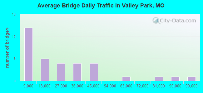
- 778,933Total average daily traffic
- 70,446Total average daily truck traffic
- National Bridge Inventory (NBI) Registered Bridges for Valley Park
- No street view available for this location
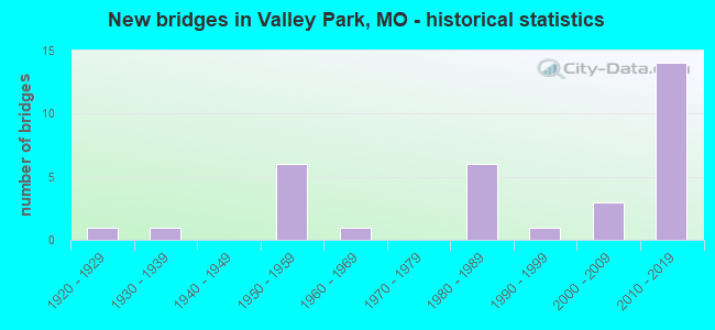
- New bridges - historical statistics
- 11920-1929
- 11930-1939
- 61950-1959
- 11960-1969
- 61980-1989
- 11990-1999
- 32000-2009
- 142010-2019
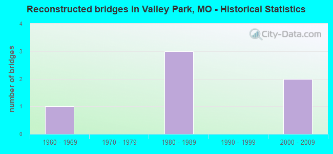
- Reconstructed bridges - Historical Statistics
- 11960-1969
- 01970-1979
- 31980-1989
- 01990-1999
- 22000-2009

- Bridge Condition - Deck
- 7.1%Excellent
- 14.3%Very good
- 57.1%Good
- 21.4%Satisfactory
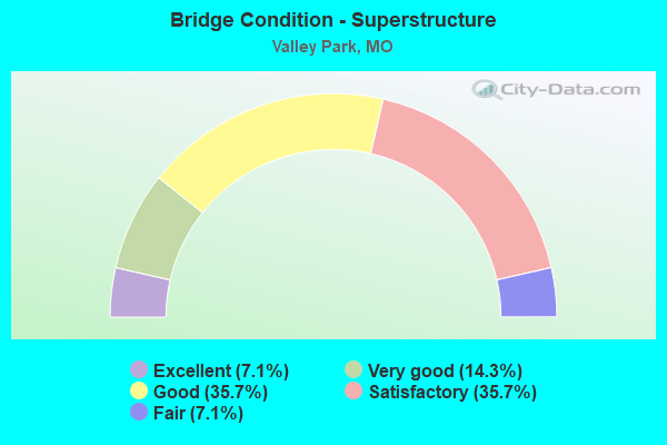
- Bridge Condition - Superstructure
- 7.1%Excellent
- 14.3%Very good
- 35.7%Good
- 35.7%Satisfactory
- 7.1%Fair
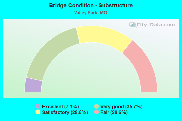
- Bridge Condition - Substructure
- 7.1%Excellent
- 35.7%Very good
- 28.6%Satisfactory
- 28.6%Fair
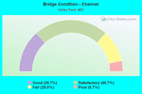
- Bridge Condition - Channel
- 26.7%Good
- 46.7%Satisfactory
- 20.0%Fair
- 6.7%Poor
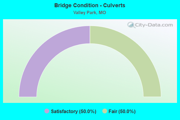
- Bridge Condition - Culverts
- 50.0%Satisfactory
- 50.0%Fair
Find on map >> Show street view
Structure Number: 15617, Location: S 9 T 44 N R 5 E (Lat: 38.568711, Lng: -90.471028), Route carried "on" structure: County highway , Year Built: 2000, Status: Posted for load, Structure Length: 3.35m (10.99ft), Average Daily Traffic: 9,412 (year 2020), Truck Traffic: 5%, Average Future Daily Traffic: 12,706 (year 2040), Design Load: HS 20, Features Intersected: GRAND GLAIZE CR, Facility Carried by Structure: BIG BEND BLVD
Minimum Vertical Clearance: 30+ m (98+ ft), Kilometerpoint: 0.000, Lanes on structure: 4, Owner: County Highway Agency, Approaching Roadway Width: 12.2m (40.0ft), Material/Design: Prestressed concrete continuous, Design/Construction: Stringer/Multi-beam, Number Of Spans In Main Unit: 3, Length of Maximum Span: 12.9m (42.3ft), Curb-To-Curb Width: 14.1m (46.3ft), Out-to-Out Width: 18.3m (60.0ft)
Condition: Deck: Good, Superstructure: Very good, Substructure: Very good, Channel: Good, Operating Rating: 87.3 metric tons, Method Used To Determine Operating Rating: Load Factor (LF), Inventory Rating: 52.2 metric tons, Method Used To Determine Inventory Rating: Load Factor (LF), Structural Evaluation: Equal to present desirable criteria, Deck Geometry: High priority of replacement, Waterway Adequacy: Equal to present desirable criteria, Approach Roadway Alignment: Equal to present desirable criteria, Length Of Structure Improvement: 0.42m (1.38ft), Designated Inspection Frequency: Every 24 months, Inspection Date: March 2020, Bridge Improvement Cost: $563,000, Roadway Improvement Cost: $56,000, Total Project Cost: $844,000 ( Estimate for 2022), Deck Structure Type: Concrete Cast-file-Place, Wearing Surface/Protective System: Wearing Surface: Monolithic Concrete, Membrane: Epoxy, Deck Protection: Epoxy Coated Reinforcing
Find on map >> Show street view
Structure Number: 15623, Location: S 16 T 44 N R 5 E (Lat: 38.554483, Lng: -90.463803), Route carried "on" structure: County highway , Year Built: 1981, Status: Posted for load, Structure Length: 4.08m (13.39ft), Average Daily Traffic: 4,171 (year 2020), Truck Traffic: 5%, Average Future Daily Traffic: 5,631 (year 2040), Design Load: HS 20, Features Intersected: GRAND GLAIZE CR, Facility Carried by Structure: MARSHALL RD
Minimum Vertical Clearance: 30+ m (98+ ft), Kilometerpoint: 0.000, Lanes on structure: 2, Owner: County Highway Agency, Approaching Roadway Width: 16.2m (53.1ft), Material/Design: Prestressed concrete, Design/Construction: Stringer/Multi-beam, Number Of Spans In Main Unit: 3, Length of Maximum Span: 13.1m (43.0ft), Curb or Sidewalk Widths: Left: 1.8m (5.9ft), Right: 1.8m (5.9ft), Curb-To-Curb Width: 16.2m (53.1ft), Out-to-Out Width: 20.6m (67.6ft)
Condition: Deck: Good, Superstructure: Good, Substructure: Satisfactory, Channel: Satisfactory, Operating Rating: 80.1 metric tons, Method Used To Determine Operating Rating: Allowable Stress (AS), Inventory Rating: 53.1 metric tons, Method Used To Determine Inventory Rating: Allowable Stress (AS), Structural Evaluation: Equal to present minimum criteria, Deck Geometry: Superior to present desirable criteria, Waterway Adequacy: Meets minimum limits, Approach Roadway Alignment: Equal to present desirable criteria, Designated Inspection Frequency: Every 24 months, Inspection Date: January 2022, Deck Structure Type: Concrete Cast-file-Place, Wearing Surface/Protective System: Wearing Surface: Monolithic Concrete, Membrane: Epoxy, Deck Protection: Epoxy Coated Reinforcing
Find on map >> Show street view
Structure Number: 15643, Location: S 24 T 44 N R 4 E (Lat: 38.534364, Lng: -90.514394), Route carried "on" structure: City street , Year Built: 1920, Year Reconstructed: 2014, Status: Posted for load, Structure Length: 1.07m (3.51ft), Average Daily Traffic: 124 (year 2018), Truck Traffic: 3%, Average Future Daily Traffic: 167 (year 2038), Design Load: H 20, Features Intersected: WILLIAMS CR, Facility Carried by Structure: ANTIRE RD
Minimum Vertical Clearance: 30+ m (98+ ft), Kilometerpoint: 5.955, Lanes on structure: 1, Owner: City or Municipal Highway Agency, Approaching Roadway Width: 4.3m (14.1ft), Material/Design: Steel, Design/Construction: Stringer/Multi-beam, Number Of Spans In Main Unit: 1, Length of Maximum Span: 9.8m (32.2ft), Curb-To-Curb Width: 3.7m (12.1ft), Out-to-Out Width: 3.7m (12.1ft)
Condition: Deck: Very good, Superstructure: Good, Substructure: Fair, Channel: Poor, Operating Rating: 29.7 metric tons, Method Used To Determine Operating Rating: Load Factor (LF), Inventory Rating: 18.0 metric tons, Method Used To Determine Inventory Rating: Load Factor (LF), Structural Evaluation: Somewhat better than minimum adequacy, Deck Geometry: High priority of replacement, Waterway Adequacy: Equal to present minimum criteria, Approach Roadway Alignment: Equal to present minimum criteria, Bridge Posting: Required (Relationship of Operating Rating to Maximum Legal Load: 10.0 - 19.9% below), Designated Inspection Frequency: Every 24 months, Critical Feature Inspection Frequency: Every 24 months, Inspection Date: November 2021, Critical Feature Inspection Date: November 2021, Deck Structure Type: Other, Wearing Surface/Protective System: Wearing Surface: Epoxy Overlay
Find on map >> Show street view
Structure Number: 28387, Location: S 30 T 44 N R 5 E (Lat: 38.530944, Lng: -90.506544), Route carried "on" structure: County highway , Year Built: 1999, Status: Posted for load, Structure Length: 2.07m (6.79ft), Average Daily Traffic: 2,019 (year 2020), Truck Traffic: 2%, Average Future Daily Traffic: 2,726 (year 2040), Design Load: HS 20, Features Intersected: N TRIB OF WILLIAMS, Facility Carried by Structure: AVALON HILLS DR
Minimum Vertical Clearance: 30+ m (98+ ft), Kilometerpoint: 0.000, Lanes on structure: 2, Owner: County Highway Agency, Approaching Roadway Width: 7.9m (25.9ft), Material/Design: Concrete, Design/Construction: Culvert, Number Of Spans In Main Unit: 2, Length of Maximum Span: 9.8m (32.2ft), Curb or Sidewalk Widths: Left: 1.9m (6.2ft), Right: 1.9m (6.2ft), Curb-To-Curb Width: 8.7m (28.5ft), Out-to-Out Width: 13.1m (43.0ft)
Condition: Channel: Fair, Culverts: Fair, Operating Rating: 89.1 metric tons, Method Used To Determine Operating Rating: Load Factor (LF), Inventory Rating: 56.7 metric tons, Method Used To Determine Inventory Rating: Load Factor (LF), Structural Evaluation: Somewhat better than minimum adequacy, Deck Geometry: Meets minimum limits, Waterway Adequacy: Equal to present desirable criteria, Approach Roadway Alignment: Equal to present desirable criteria, Designated Inspection Frequency: Every 24 months, Inspection Date: March 2021, Deck Structure Type: Concrete Cast-file-Place, Wearing Surface/Protective System: Wearing Surface: Monolithic Concrete
Find on map >> Show street view
Structure Number: 31451, Location: S 30 T 44 N R 5 E (Lat: 38.529544, Lng: -90.502211), Route carried "on" structure: County highway , Year Built: 2005, Status: Posted for load, Structure Length: 1.31m (4.30ft), Average Daily Traffic: 3,129 (year 2020), Truck Traffic: 3%, Average Future Daily Traffic: 4,224 (year 2040), Design Load: HS 20, Features Intersected: N TRIB OF WILLIAMS, Facility Carried by Structure: SMIZER MILL RD
Minimum Vertical Clearance: 30+ m (98+ ft), Kilometerpoint: 0.000, Lanes on structure: 2, Owner: County Highway Agency, Approaching Roadway Width: 11.9m (39.0ft), Skew: 1 degrees, Material/Design: Concrete, Design/Construction: Culvert, Number Of Spans In Main Unit: 1, Length of Maximum Span: 12.8m (42.0ft)
Condition: Channel: Satisfactory, Culverts: Satisfactory, Operating Rating: 52.2 metric tons, Method Used To Determine Operating Rating: Load Factor (LF), Inventory Rating: 31.5 metric tons, Method Used To Determine Inventory Rating: Load Factor (LF), Structural Evaluation: Equal to present minimum criteria, Waterway Adequacy: Superior to present desirable criteria, Approach Roadway Alignment: Equal to present minimum criteria, Designated Inspection Frequency: Every 24 months, Inspection Date: March 2021
Find on map >> Show street view
Structure Number: 32405, Location: S 30 T 44 N R 5 E (Lat: 38.516656, Lng: -90.512069), Route carried "on" structure: County highway 141, Year Built: 2007, Status: Posted for load, Structure Length: 0.79m (2.59ft), Average Daily Traffic: 5,816 (year 2020), Truck Traffic: 3%, Average Future Daily Traffic: 7,852 (year 2040), Design Load: HS 20, Features Intersected: E TRIB OF WILLIAMS, Facility Carried by Structure: HILLSBORO RD
Minimum Vertical Clearance: 30+ m (98+ ft), Kilometerpoint: 0.000, Lanes on structure: 2, Owner: County Highway Agency, Approaching Roadway Width: 9.8m (32.2ft), Material/Design: Concrete continuous, Design/Construction: Culvert, Number Of Spans In Main Unit: 2, Length of Maximum Span: 3.7m (12.1ft), Curb or Sidewalk Widths: Left: 1.5m (4.9ft), Right: 0.0m
Condition: Channel: Satisfactory, Culverts: Fair, Operating Rating: 85.5 metric tons, Method Used To Determine Operating Rating: Load Factor (LF), Inventory Rating: 51.3 metric tons, Method Used To Determine Inventory Rating: Load Factor (LF), Structural Evaluation: Somewhat better than minimum adequacy, Waterway Adequacy: Superior to present desirable criteria, Approach Roadway Alignment: Equal to present minimum criteria, Designated Inspection Frequency: Every 24 months, Inspection Date: March 2021
Find on map >> Show street view
Structure Number: 329, Location: S 18 T 44 N R 5 E (Lat: 38.546439, Lng: -90.494511), Route carried "on" structure: State highway 141, Year Built: 1983, Status: Open, Structure Length: 19.35m (63.48ft), Average Daily Traffic: 58,355 (year 2021), Truck Traffic: 5%, Average Future Daily Traffic: 72,944 (year 2041), Design Load: HS 20+Mod, Features Intersected: MERAMEC RVR
Minimum Vertical Clearance: 30+ m (98+ ft), Kilometerpoint: 30.874, Lanes on structure: 6, Base Highway Network: Yes, Owner: State Highway Agency, Approaching Roadway Width: 25.0m (82.0ft), Material/Design: Steel continuous, Design/Construction: Stringer/Multi-beam, Number Of Spans In Main Unit: 3, Number Of Approach Spans: 4, Length of Maximum Span: 45.7m (149.9ft), Curb-To-Curb Width: 24.4m (80.1ft), Out-to-Out Width: 25.8m (84.6ft)
Condition: Deck: Good, Superstructure: Fair, Substructure: Fair, Channel: Fair, Operating Rating: 59.4 metric tons, Method Used To Determine Operating Rating: Load Factor (LF), Inventory Rating: 36.0 metric tons, Method Used To Determine Inventory Rating: Load Factor (LF), Structural Evaluation: Somewhat better than minimum adequacy, Deck Geometry: Meets minimum limits, Waterway Adequacy: Equal to present desirable criteria, Approach Roadway Alignment: Equal to present desirable criteria, Designated Inspection Frequency: Every 24 months, Underwater Inspection Frequency: Every 60 months, Inspection Date: June 2020, Underwater Inspection Date: June 2020, Deck Structure Type: Concrete Cast-file-Place, Wearing Surface/Protective System: Wearing Surface: Epoxy Overlay, Deck Protection: Epoxy Coated Reinforcing
Find on map >> Show street view
Structure Number: 3369, Location: S 19 T 44 N R 5 E (Lat: 38.541458, Lng: -90.495244), Route carried "on" structure: State highway 141, Year Built: 1984, Status: Open, Structure Length: 13.53m (44.39ft), Average Daily Traffic: 27,936 (year 2021), Truck Traffic: 5%, Average Future Daily Traffic: 34,920 (year 2041), Design Load: HS 20, Features Intersected: OR 44, BNSF RR
Minimum Vertical Clearance: 30+ m (98+ ft), Kilometerpoint: 18.097, Lanes on structure: 3, Lanes under structure: 2, Base Highway Network: Yes, Owner: State Highway Agency, Approaching Roadway Width: 10.7m (35.1ft), Skew: 14 degrees, Material/Design: Prestressed concrete continuous, Design/Construction: Stringer/Multi-beam, Number Of Spans In Main Unit: 6, Length of Maximum Span: 27.1m (88.9ft), Curb or Sidewalk Widths: Left: 0.2m (0.7ft), Right: 0.2m (0.7ft), Curb-To-Curb Width: 11.6m (38.1ft), Out-to-Out Width: 12.6m (41.3ft)
Condition: Deck: Good, Superstructure: Satisfactory, Substructure: Satisfactory, Operating Rating: 59.4 metric tons, Method Used To Determine Operating Rating: Load Factor (LF), Inventory Rating: 31.5 metric tons, Method Used To Determine Inventory Rating: Load Factor (LF), Structural Evaluation: Equal to present minimum criteria, Deck Geometry: High priority of replacement, Underclear: Superior to present desirable criteria, Approach Roadway Alignment: Equal to present minimum criteria, Length Of Structure Improvement: 1.43m (4.69ft), Designated Inspection Frequency: Every 24 months, Inspection Date: June 2020, Bridge Improvement Cost: $1,511,000, Roadway Improvement Cost: $151,000, Total Project Cost: $2,267,000 ( Estimate for 2022), Deck Structure Type: Concrete Cast-file-Place, Wearing Surface/Protective System: Wearing Surface: Epoxy Overlay, Deck Protection: Epoxy Coated Reinforcing
Find on map >> Show street view
Structure Number: 337, Location: S 19 T 44 N R 5 E (Lat: 38.541342, Lng: -90.495481), Route carried "on" structure: State highway 141, Year Built: 1984, Status: Open, Structure Length: 12.89m (42.29ft), Average Daily Traffic: 30,419 (year 2021), Truck Traffic: 5%, Average Future Daily Traffic: 38,024 (year 2041), Design Load: HS 20, Features Intersected: OR 44, BNSF RR
Minimum Vertical Clearance: 30+ m (98+ ft), Kilometerpoint: 31.440, Lanes on structure: 3, Lanes under structure: 2, Base Highway Network: Yes, Owner: State Highway Agency, Approaching Roadway Width: 10.7m (35.1ft), Skew: 14 degrees, Material/Design: Prestressed concrete continuous, Design/Construction: Stringer/Multi-beam, Number Of Spans In Main Unit: 6, Length of Maximum Span: 25.0m (82.0ft), Curb or Sidewalk Widths: Left: 0.2m (0.7ft), Right: 0.2m (0.7ft), Curb-To-Curb Width: 11.6m (38.1ft), Out-to-Out Width: 12.6m (41.3ft)
Condition: Deck: Good, Superstructure: Satisfactory, Substructure: Satisfactory, Operating Rating: 63.0 metric tons, Method Used To Determine Operating Rating: Load Factor (LF), Inventory Rating: 36.0 metric tons, Method Used To Determine Inventory Rating: Load Factor (LF), Structural Evaluation: Equal to present minimum criteria, Deck Geometry: High priority of replacement, Underclear: Superior to present desirable criteria, Approach Roadway Alignment: Equal to present minimum criteria, Length Of Structure Improvement: 1.37m (4.49ft), Designated Inspection Frequency: Every 24 months, Inspection Date: June 2020, Bridge Improvement Cost: $1,447,000, Roadway Improvement Cost: $145,000, Total Project Cost: $2,171,000 ( Estimate for 2022), Deck Structure Type: Concrete Cast-file-Place, Wearing Surface/Protective System: Wearing Surface: Epoxy Overlay, Deck Protection: Epoxy Coated Reinforcing
Find on map >> Show street view
Structure Number: 33736, Location: S 17 T 44 N R 5 E (Lat: 38.552100, Lng: -90.511531), Route carried "on" structure: City street , Year Built: 2013, Status: Open, Structure Length: 2.23m (7.32ft), Average Daily Traffic: 6,000 (year 2020), Truck Traffic: 1%, Average Future Daily Traffic: 8,100 (year 2040), Features Intersected: FISHPOT CR, Facility Carried by Structure: HANNA RD
Minimum Vertical Clearance: 30+ m (98+ ft), Kilometerpoint: 0.000, Lanes on structure: 2, Owner: City or Municipal Highway Agency, Approaching Roadway Width: 9.8m (32.2ft), Skew: 1 degrees, Material/Design: Prestressed concrete, Design/Construction: Stringer/Multi-beam, Number Of Spans In Main Unit: 1, Length of Maximum Span: 22.3m (73.2ft), Curb or Sidewalk Widths: Left: 0.0m, Right: 1.7m (5.6ft), Curb-To-Curb Width: 9.8m (32.2ft), Out-to-Out Width: 12.4m (40.7ft)
Condition: Deck: Good, Superstructure: Good, Substructure: Very good, Channel: Fair, Operating Rating: 71.1 metric tons, Method Used To Determine Operating Rating: Load Factor (LF), Inventory Rating: 39.6 metric tons, Method Used To Determine Inventory Rating: Load Factor (LF), Structural Evaluation: Better than present minimum criteria, Deck Geometry: Meets minimum limits, Waterway Adequacy: Equal to present desirable criteria, Approach Roadway Alignment: Equal to present desirable criteria, Designated Inspection Frequency: Every 24 months, Inspection Date: November 2021, Deck Structure Type: Concrete Cast-file-Place, Wearing Surface/Protective System: Wearing Surface: Monolithic Concrete
Find on map >> Show street view
Structure Number: 33929, Location: S 24 T 44 N R 4 E (Lat: 38.536678, Lng: -90.513067), Route carried "on" structure: ServiceState highway 44, Year Built: 2012, Status: Open, Structure Length: 3.66m (12.01ft), Average Daily Traffic: 984 (year 2021), Truck Traffic: 3%, Average Future Daily Traffic: 1,476 (year 2041), Design Load: HS 20+Mod, Features Intersected: WILLIAMS CR
Minimum Vertical Clearance: 30+ m (98+ ft), Kilometerpoint: 0.990, Lanes on structure: 2, Owner: State Highway Agency, Approaching Roadway Width: 7.3m (24.0ft), Material/Design: Prestressed concrete, Design/Construction: Box Beam or Girders - Multiple, Number Of Spans In Main Unit: 2, Length of Maximum Span: 22.9m (75.1ft), Curb-To-Curb Width: 7.3m (24.0ft), Out-to-Out Width: 7.9m (25.9ft)
Condition: Deck: Very good, Superstructure: Good, Substructure: Very good, Channel: Good, Operating Rating: 76.5 metric tons, Method Used To Determine Operating Rating: Load Factor (LF), Inventory Rating: 43.2 metric tons, Method Used To Determine Inventory Rating: Load Factor (LF), Structural Evaluation: Better than present minimum criteria, Deck Geometry: Meets minimum limits, Waterway Adequacy: Somewhat better than minimum adequacy, Approach Roadway Alignment: Equal to present desirable criteria, Designated Inspection Frequency: Every 24 months, Inspection Date: July 2020, Deck Structure Type: Concrete Precast Panels, Wearing Surface/Protective System: Wearing Surface: Bituminous
Find on map >> Show street view
Structure Number: 35233, Location: S 1983 T 44 N R 5 E (Lat: 38.539656, Lng: -90.495547), Route carried "on" structure: Ramp State highway , Year Built: 2016, Status: Open, Structure Length: 4.86m (15.94ft), Average Daily Traffic: 11,676 (year 2020), Truck Traffic: 10%, Average Future Daily Traffic: 14,595 (year 2040), Features Intersected: MO 141, Facility Carried by Structure: RP MO141N TO IS44W
Minimum Vertical Clearance: 30+ m (98+ ft), Kilometerpoint: 0.426, Lanes on structure: 2, Lanes under structure: 8, Base Highway Network: Yes, Owner: State Highway Agency, Approaching Roadway Width: 11.0m (36.1ft), Skew: 1 degrees, Material/Design: Prestressed concrete, Design/Construction: Tee Beam, Number Of Spans In Main Unit: 1, Length of Maximum Span: 47.5m (155.8ft), Curb-To-Curb Width: 11.2m (36.7ft), Out-to-Out Width: 11.9m (39.0ft)
Condition: Deck: Good, Superstructure: Very good, Substructure: Very good, Operating Rating: 67.5 metric tons, Method Used To Determine Operating Rating: Load and Resistance Factor (LRFR), Inventory Rating: 40.5 metric tons, Method Used To Determine Inventory Rating: Load and Resistance Factor (LRFR), Structural Evaluation: Equal to present desirable criteria, Deck Geometry: Superior to present desirable criteria, Underclear: High priority of corrective action, Approach Roadway Alignment: Equal to present desirable criteria, Designated Inspection Frequency: Every 24 months, Inspection Date: June 2020, Deck Structure Type: Concrete Cast-file-Place, Wearing Surface/Protective System: Wearing Surface: Monolithic Concrete, Deck Protection: Epoxy Coated Reinforcing
Find on map >> Show street view
Structure Number: 35237, Location: S 1983 T 44 N R 5 E (Lat: 38.540131, Lng: -90.496214), Route carried "on" structure: Ramp State highway , Year Built: 2016, Status: Open, Structure Length: 39.95m (131.07ft), Average Daily Traffic: 6,639 (year 2020), Truck Traffic: 10%, Average Future Daily Traffic: 8,299 (year 2040), Features Intersected: IS 44, OR 44, RP MO141, Facility Carried by Structure: RP MO141S TO IS44E
Minimum Vertical Clearance: 30+ m (98+ ft), Kilometerpoint: 0.204, Lanes on structure: 1, Lanes under structure: 19, Base Highway Network: Yes, Owner: State Highway Agency, Approaching Roadway Width: 7.9m (25.9ft), Skew: 2 degrees, Material/Design: Prestressed concrete continuous, Design/Construction: Tee Beam, Number Of Spans In Main Unit: 3, Number Of Approach Spans: 9, Length of Maximum Span: 48.2m (158.1ft), Curb-To-Curb Width: 7.9m (25.9ft), Out-to-Out Width: 8.7m (28.5ft)
Condition: Deck: Good, Superstructure: Good, Substructure: Very good, Operating Rating: 67.5 metric tons, Method Used To Determine Operating Rating: Load Factor (LF), Inventory Rating: 40.5 metric tons, Method Used To Determine Inventory Rating: Load Factor (LF), Structural Evaluation: Better than present minimum criteria, Deck Geometry: Equal to present desirable criteria, Underclear: High priority of corrective action, Approach Roadway Alignment: Equal to present minimum criteria, Designated Inspection Frequency: Every 24 months, Inspection Date: June 2020, Deck Structure Type: Concrete Cast-file-Place, Wearing Surface/Protective System: Wearing Surface: Monolithic Concrete, Deck Protection: Epoxy Coated Reinforcing
Find on map >> Show street view
Structure Number: 35627, Location: S 2999 T 44 N R 5 E (Lat: 38.551944, Lng: -90.499722), Route carried "on" structure: County highway , Year Built: 2018, Status: Open, Structure Length: 3.23m (10.60ft), Average Daily Traffic: 10,679 (year 2020), Truck Traffic: 5%, Average Future Daily Traffic: 14,417 (year 2040), Features Intersected: FISHPOT CR, Facility Carried by Structure: VANCE RD
Minimum Vertical Clearance: 30+ m (98+ ft), Kilometerpoint: 10.944, Lanes on structure: 2, Owner: County Highway Agency, Approaching Roadway Width: 9.8m (32.2ft), Skew: 1 degrees, Material/Design: Prestressed concrete, Design/Construction: Tee Beam, Number Of Spans In Main Unit: 1, Length of Maximum Span: 31.2m (102.4ft), Curb or Sidewalk Widths: Left: 3.0m (9.8ft), Right: 0.0m, Curb-To-Curb Width: 9.8m (32.2ft), Out-to-Out Width: 13.8m (45.3ft)
Condition: Deck: Excellent, Superstructure: Excellent, Substructure: Excellent, Channel: Satisfactory, Operating Rating: 72.9 metric tons, Method Used To Determine Operating Rating: Load Factor (LF), Inventory Rating: 55.8 metric tons, Method Used To Determine Inventory Rating: Load Factor (LF), Structural Evaluation: Superior to present desirable criteria, Deck Geometry: Meets minimum limits, Waterway Adequacy: Superior to present desirable criteria, Approach Roadway Alignment: Equal to present desirable criteria, Designated Inspection Frequency: Every 24 months, Inspection Date: Febuary 2021, Deck Structure Type: Concrete Cast-file-Place, Wearing Surface/Protective System: Wearing Surface: Monolithic Concrete, Deck Protection: Epoxy Coated Reinforcing
Find on map >> Show street view
Structure Number: 5318, Location: S 24 T 44 N R 4 E (Lat: 38.533661, Lng: -90.520531), Route carried "on" structure: Interstate 44, Year Built: 1930, Year Reconstructed: 1989, Status: Open, Structure Length: 1.51m (4.95ft), Average Daily Traffic: 83,352 (year 2021), Truck Traffic: 12%, Average Future Daily Traffic: 104,190 (year 2041), Design Load: HS 20+Mod, Features Intersected: RANKEN BR
Minimum Vertical Clearance: 30+ m (98+ ft), Kilometerpoint: 436.065, Lanes on structure: 6, Base Highway Network: Yes, Owner: State Highway Agency, Approaching Roadway Width: 44.5m (146.0ft), Skew: 26 degrees, Material/Design: Concrete continuous, Design/Construction: Culvert, Number Of Spans In Main Unit: 2, Length of Maximum Span: 3.0m (9.8ft)
Condition: Channel: Satisfactory, Culverts: Fair, Operating Rating: 48.6 metric tons, Method Used To Determine Operating Rating: Load Factor (LF), Inventory Rating: 28.8 metric tons, Method Used To Determine Inventory Rating: Load Factor (LF), Structural Evaluation: Somewhat better than minimum adequacy, Waterway Adequacy: Equal to present desirable criteria, Approach Roadway Alignment: Equal to present desirable criteria, Designated Inspection Frequency: Every 24 months, Inspection Date: November 2021
Find on map >> Show street view
Structure Number: 5319, Location: S 879 T 44 N R 4 E (Lat: 38.536267, Lng: -90.512994), Route carried "on" structure: Interstate 44, Year Built: 1960, Year Reconstructed: 1989, Status: Open, Structure Length: 4.97m (16.31ft), Average Daily Traffic: 42,018 (year 2021), Truck Traffic: 12%, Average Future Daily Traffic: 52,523 (year 2041), Design Load: HS 20, Features Intersected: WILLIAMS CR
Minimum Vertical Clearance: 30+ m (98+ ft), Kilometerpoint: 436.745, Lanes on structure: 3, Base Highway Network: Yes, Owner: State Highway Agency, Approaching Roadway Width: 16.2m (53.1ft), Material/Design: Steel, Design/Construction: Stringer/Multi-beam, Number Of Spans In Main Unit: 5, Length of Maximum Span: 11.3m (37.1ft), Curb or Sidewalk Widths: Left: 0.2m (0.7ft), Right: 0.2m (0.7ft), Curb-To-Curb Width: 15.8m (51.8ft), Out-to-Out Width: 16.6m (54.5ft)
Condition: Deck: Satisfactory, Superstructure: Satisfactory, Substructure: Fair, Channel: Good, Operating Rating: 88.2 metric tons, Method Used To Determine Operating Rating: Load Factor (LF), Inventory Rating: 53.1 metric tons, Method Used To Determine Inventory Rating: Load Factor (LF), Structural Evaluation: Somewhat better than minimum adequacy, Deck Geometry: Somewhat better than minimum adequacy, Waterway Adequacy: Equal to present minimum criteria, Approach Roadway Alignment: Equal to present desirable criteria, Designated Inspection Frequency: Every 24 months, Inspection Date: July 2020, Deck Structure Type: Concrete Cast-file-Place, Wearing Surface/Protective System: Wearing Surface: Monolithic Concrete, Deck Protection: Epoxy Coated Reinforcing
Find on map >> Show street view
Structure Number: 558, Location: S 1983 T 44 N R 5 E (Lat: 38.539117, Lng: -90.495608), Route carried "on" structure: Interstate 44, Year Built: 1958, Year Reconstructed: 2014, Status: Open, Structure Length: 6.61m (21.69ft), Average Daily Traffic: 93,404 (year 2021), Truck Traffic: 12%, Average Future Daily Traffic: 116,755 (year 2041), Design Load: HS 20+Mod, Features Intersected: MO 141
Minimum Vertical Clearance: 30+ m (98+ ft), Kilometerpoint: 438.331, Lanes on structure: 6, Lanes under structure: 9, Base Highway Network: Yes, Owner: State Highway Agency, Approaching Roadway Width: 32.9m (107.9ft), Skew: 21 degrees, Material/Design: Steel continuous, Design/Construction: Stringer/Multi-beam, Number Of Spans In Main Unit: 4, Length of Maximum Span: 21.3m (69.9ft), Curb-To-Curb Width: 32.2m (105.6ft), Out-to-Out Width: 33.7m (110.6ft)
Condition: Deck: Satisfactory, Superstructure: Satisfactory, Substructure: Satisfactory, Operating Rating: 57.6 metric tons, Method Used To Determine Operating Rating: Load Factor (LF), Inventory Rating: 35.1 metric tons, Method Used To Determine Inventory Rating: Load Factor (LF), Structural Evaluation: Equal to present minimum criteria, Deck Geometry: Superior to present desirable criteria, Underclear: High priority of corrective action, Approach Roadway Alignment: Equal to present desirable criteria, Designated Inspection Frequency: Every 24 months, Inspection Date: June 2020, Deck Structure Type: Concrete Cast-file-Place, Wearing Surface/Protective System: Wearing Surface: Monolithic Concrete, Deck Protection: Epoxy Coated Reinforcing
Find on map >> Show street view
Structure Number: 6443, Location: S 24 T 44 N R 4 E (Lat: 38.536392, Lng: -90.513008), Route carried "on" structure: Interstate 44, Year Built: 1958, Year Reconstructed: 1989, Status: Open, Structure Length: 4.97m (16.31ft), Average Daily Traffic: 41,334 (year 2021), Truck Traffic: 12%, Average Future Daily Traffic: 51,668 (year 2041), Design Load: HS 20, Features Intersected: WILLIAMS CR
Minimum Vertical Clearance: 30+ m (98+ ft), Kilometerpoint: 35.010, Lanes on structure: 3, Base Highway Network: Yes, Owner: State Highway Agency, Approaching Roadway Width: 16.2m (53.1ft), Material/Design: Steel, Design/Construction: Stringer/Multi-beam, Number Of Spans In Main Unit: 5, Length of Maximum Span: 11.3m (37.1ft), Curb or Sidewalk Widths: Left: 0.2m (0.7ft), Right: 0.2m (0.7ft), Curb-To-Curb Width: 15.8m (51.8ft), Out-to-Out Width: 17.1m (56.1ft)
Condition: Deck: Satisfactory, Superstructure: Satisfactory, Substructure: Fair, Channel: Good, Operating Rating: 85.5 metric tons, Method Used To Determine Operating Rating: Load Factor (LF), Inventory Rating: 51.3 metric tons, Method Used To Determine Inventory Rating: Load Factor (LF), Structural Evaluation: Somewhat better than minimum adequacy, Deck Geometry: Somewhat better than minimum adequacy, Waterway Adequacy: Equal to present minimum criteria, Approach Roadway Alignment: Equal to present desirable criteria, Designated Inspection Frequency: Every 24 months, Inspection Date: July 2020, Deck Structure Type: Concrete Cast-file-Place, Wearing Surface/Protective System: Wearing Surface: Monolithic Concrete, Deck Protection: Epoxy Coated Reinforcing
Find on map >> Show street view
Structure Number: 6444, Location: S 880 T 44 N R 5 E (Lat: 38.537306, Lng: -90.506447), Route carried "on" structure: Interstate 44, Year Built: 1958, Year Reconstructed: 1960, Status: Open, Structure Length: 0.79m (2.59ft), Average Daily Traffic: 80,923 (year 2021), Truck Traffic: 12%, Average Future Daily Traffic: 101,154 (year 2041), Design Load: HS 20, Features Intersected: WILLIAMS CR
Minimum Vertical Clearance: 30+ m (98+ ft), Kilometerpoint: 437.358, Lanes on structure: 6, Base Highway Network: Yes, Owner: State Highway Agency, Approaching Roadway Width: 32.9m (107.9ft), Skew: 20 degrees, Material/Design: Concrete continuous, Design/Construction: Culvert, Number Of Spans In Main Unit: 2, Length of Maximum Span: 3.7m (12.1ft)
Condition: Channel: Satisfactory, Culverts: Satisfactory, Operating Rating: 72.0 metric tons, Method Used To Determine Operating Rating: Field evaluation and documented engineering judgment, Inventory Rating: 43.2 metric tons, Method Used To Determine Inventory Rating: Field evaluation and documented engineering judgment, Structural Evaluation: Equal to present minimum criteria, Waterway Adequacy: Equal to present desirable criteria, Approach Roadway Alignment: Equal to present desirable criteria, Designated Inspection Frequency: Every 24 months, Inspection Date: November 2021
Find on map >> Show street view
Structure Number: 6834, Location: S 880 T 44 N R 5 E (Lat: 38.537728, Lng: -90.506547), Route carried "on" structure: ServiceState highway 44, Year Built: 1958, Status: Open, Structure Length: 0.75m (2.46ft), Average Daily Traffic: 984 (year 2021), Truck Traffic: 3%, Average Future Daily Traffic: 1,476 (year 2041), Design Load: H 10, Features Intersected: WILLIAMS CR
Minimum Vertical Clearance: 30+ m (98+ ft), Kilometerpoint: 1.582, Lanes on structure: 2, Owner: State Highway Agency, Approaching Roadway Width: 6.1m (20.0ft), Material/Design: Concrete continuous, Design/Construction: Culvert, Number Of Spans In Main Unit: 2, Length of Maximum Span: 3.7m (12.1ft), Curb-To-Curb Width: 7.8m (25.6ft), Out-to-Out Width: 8.4m (27.6ft)
Condition: Channel: Satisfactory, Culverts: Satisfactory, Operating Rating: 38.7 metric tons, Method Used To Determine Operating Rating: Load Factor (LF), Inventory Rating: 23.4 metric tons, Method Used To Determine Inventory Rating: Load Factor (LF), Structural Evaluation: Equal to present minimum criteria, Deck Geometry: Meets minimum limits, Waterway Adequacy: Better than present minimum criteria, Approach Roadway Alignment: Equal to present desirable criteria, Designated Inspection Frequency: Every 24 months, Inspection Date: November 2021
Find on map >> Show street view
Structure Number: 3369, Location: S 19 T 44 N R 5 E (Lat: 38.541458, Lng: -90.495244), Route carried "under" structure: ServiceState highway 44, Year Built: 1984, Structure Length: 0. m, Average Daily Traffic: 984 (year 2021), Truck Traffic: 3%, Features Intersected: OR 44, Facility Carried by Structure: MO 141 N
Minimum Vertical Clearance: 6.34m (20.80ft), Kilometerpoint: 2.702, Lanes on structure: 3, Lanes under structure: 2, Material/Design: Prestressed concrete continuous, Design/Construction: Stringer/Multi-beam, Length of Maximum Span: 27.1m (88.9ft)
Find on map >> Show street view
Structure Number: 337, Location: S 19 T 44 N R 5 E (Lat: 38.541342, Lng: -90.495481), Route carried "under" structure: ServiceState highway 44, Year Built: 1984, Structure Length: 0. m, Average Daily Traffic: 984 (year 2021), Truck Traffic: 3%, Features Intersected: OR 44, Facility Carried by Structure: MO 141 S
Minimum Vertical Clearance: 5.09m (16.70ft), Kilometerpoint: 2.673, Lanes on structure: 3, Lanes under structure: 2, Material/Design: Prestressed concrete continuous, Design/Construction: Stringer/Multi-beam, Length of Maximum Span: 25.0m (82.0ft)
Find on map >> Show street view
Structure Number: 35233, Location: S 1983 T 44 N R 5 E (Lat: 38.539656, Lng: -90.495547), Route carried "under" structure: State highway 141, Year Built: 2016, Structure Length: 0. m, Average Daily Traffic: 30,419 (year 2021), Truck Traffic: 5%, Features Intersected: MO 141
Minimum Vertical Clearance: 5.03m (16.50ft), Kilometerpoint: 31.731, Lanes on structure: 2, Lanes under structure: 4, Material/Design: Prestressed concrete, Design/Construction: Tee Beam, Length of Maximum Span: 47.5m (155.8ft)
Find on map >> Show street view
Structure Number: 35233, Location: S 1983 T 44 N R 5 E (Lat: 38.539656, Lng: -90.495547), Route carried "under" structure: State highway 141, Year Built: 2016, Structure Length: 0. m, Average Daily Traffic: 27,936 (year 2021), Truck Traffic: 5%, Features Intersected: MO 141
Minimum Vertical Clearance: 5.03m (16.50ft), Kilometerpoint: 17.943, Lanes on structure: 2, Lanes under structure: 4, Material/Design: Prestressed concrete, Design/Construction: Tee Beam, Length of Maximum Span: 47.5m (155.8ft)
Find on map >> Show street view
Structure Number: 35237, Location: S 1983 T 44 N R 5 E (Lat: 38.540131, Lng: -90.496214), Route carried "under" structure: State highway 141, Year Built: 2016, Structure Length: 0. m, Average Daily Traffic: 21,521 (year 2021), Truck Traffic: 6%, Features Intersected: MO 141
Minimum Vertical Clearance: 8.13m (26.67ft), Kilometerpoint: 31.809, Lanes on structure: 1, Lanes under structure: 3, Material/Design: Prestressed concrete continuous, Design/Construction: Tee Beam, Length of Maximum Span: 48.2m (158.1ft)
Find on map >> Show street view
Structure Number: 35237, Location: S 1983 T 44 N R 5 E (Lat: 38.540131, Lng: -90.496214), Route carried "under" structure: State highway 141, Year Built: 2016, Structure Length: 0. m, Average Daily Traffic: 22,288 (year 2021), Truck Traffic: 5%, Features Intersected: MO 141
Minimum Vertical Clearance: 7.77m (25.49ft), Kilometerpoint: 17.854, Lanes on structure: 1, Lanes under structure: 4, Material/Design: Prestressed concrete continuous, Design/Construction: Tee Beam, Length of Maximum Span: 48.2m (158.1ft)
Find on map >> Show street view
Structure Number: 35237, Location: S 1983 T 44 N R 5 E (Lat: 38.540131, Lng: -90.496214), Route carried "under" structure: Ramp State highway , Year Built: 2016, Structure Length: 0. m, Average Daily Traffic: 11,676 (year 2020), Truck Traffic: 10%, Features Intersected: RP MO141N TO IS44W, Facility Carried by Structure: RP MO141S TO IS44E
Minimum Vertical Clearance: 5.66m (18.57ft), Kilometerpoint: 0.531, Lanes on structure: 1, Lanes under structure: 1, Material/Design: Prestressed concrete continuous, Design/Construction: Tee Beam, Length of Maximum Span: 48.2m (158.1ft)
Find on map >> Show street view
Structure Number: 35237, Location: S 1983 T 44 N R 5 E (Lat: 38.540131, Lng: -90.496214), Route carried "under" structure: Interstate 44, Year Built: 2016, Structure Length: 0. m, Average Daily Traffic: 42,018 (year 2021), Truck Traffic: 12%, Features Intersected: IS 44
Minimum Vertical Clearance: 5.03m (16.50ft), Kilometerpoint: 438.317, Lanes on structure: 1, Lanes under structure: 3, Material/Design: Prestressed concrete continuous, Design/Construction: Tee Beam, Length of Maximum Span: 48.2m (158.1ft)
Find on map >> Show street view
Structure Number: 35237, Location: S 1983 T 44 N R 5 E (Lat: 38.540131, Lng: -90.496214), Route carried "under" structure: Interstate 44, Year Built: 2016, Structure Length: 0. m, Average Daily Traffic: 38,905 (year 2021), Truck Traffic: 12%, Features Intersected: IS 44
Minimum Vertical Clearance: 5.56m (18.24ft), Kilometerpoint: 33.391, Lanes on structure: 1, Lanes under structure: 3, Material/Design: Prestressed concrete continuous, Design/Construction: Tee Beam, Length of Maximum Span: 48.2m (158.1ft)
Find on map >> Show street view
Structure Number: 35237, Location: S 1983 T 44 N R 5 E (Lat: 38.540131, Lng: -90.496214), Route carried "under" structure: Ramp State highway , Year Built: 2016, Structure Length: 0. m, Average Daily Traffic: 6,801 (year 2021), Truck Traffic: 5%, Features Intersected: RP MO141 TO IS44W, Facility Carried by Structure: RP MO141S TO IS44E
Minimum Vertical Clearance: 4.78m (15.68ft), Kilometerpoint: 0.077, Lanes on structure: 1, Lanes under structure: 2, Material/Design: Prestressed concrete continuous, Design/Construction: Tee Beam, Length of Maximum Span: 48.2m (158.1ft)
Find on map >> Show street view
Structure Number: 35237, Location: S 1983 T 44 N R 5 E (Lat: 38.540131, Lng: -90.496214), Route carried "under" structure: Ramp State highway , Year Built: 2016, Structure Length: 0. m, Average Daily Traffic: 12,218 (year 2020), Truck Traffic: 10%, Features Intersected: RP OR44W TO MO141S, Facility Carried by Structure: RP MO141S TO IS44E
Minimum Vertical Clearance: 6.86m (22.51ft), Kilometerpoint: 0.721, Lanes on structure: 1, Lanes under structure: 1, Material/Design: Prestressed concrete continuous, Design/Construction: Tee Beam, Length of Maximum Span: 48.2m (158.1ft)
Find on map >> Show street view
Structure Number: 558, Location: S 1983 T 44 N R 5 E (Lat: 38.539117, Lng: -90.495608), Route carried "under" structure: State highway 141, Year Built: 1958, Structure Length: 0. m, Average Daily Traffic: 22,288 (year 2021), Truck Traffic: 5%, Features Intersected: MO 141, Facility Carried by Structure: IS 44 E
Minimum Vertical Clearance: 5.00m (16.40ft), Kilometerpoint: 17.901, Lanes on structure: 6, Lanes under structure: 4, Material/Design: Steel continuous, Design/Construction: Stringer/Multi-beam, Length of Maximum Span: 21.3m (69.9ft)
Find on map >> Show street view
Structure Number: 558, Location: S 1983 T 44 N R 5 E (Lat: 38.539117, Lng: -90.495608), Route carried "under" structure: State highway 141, Year Built: 1958, Structure Length: 0. m, Average Daily Traffic: 21,521 (year 2021), Truck Traffic: 6%, Features Intersected: MO 141, Facility Carried by Structure: IS 44 E
Minimum Vertical Clearance: 5.03m (16.50ft), Kilometerpoint: 31.773, Lanes on structure: 6, Lanes under structure: 5, Material/Design: Steel continuous, Design/Construction: Stringer/Multi-beam, Length of Maximum Span: 21.3m (69.9ft)