Bridge Statistics for Vadnais Heights, Minnesota (MN)
Condition, Traffic, Stress, Structural Evaluation, Project Costs
- National Bridge Inventory (NBI) Statistics
- 29Number of bridges
- 358ft / 109mTotal length
- $114,001,000Total costs
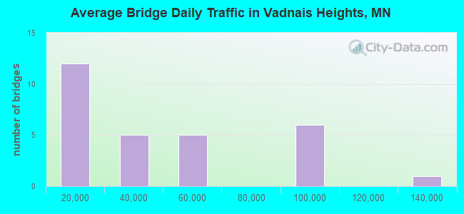
- 1,136,366Total average daily traffic
- 60,947Total average daily truck traffic
- National Bridge Inventory (NBI) Registered Bridges for Vadnais Heights
- No street view available for this location
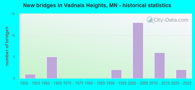
- New bridges - historical statistics
- 11950-1959
- 51960-1969
- 21990-1999
- 132000-2009
- 62010-2019
- 22020-2022
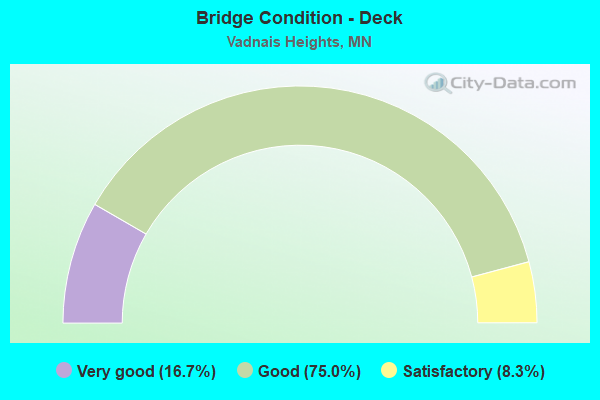
- Bridge Condition - Deck
- 16.7%Very good
- 75.0%Good
- 8.3%Satisfactory
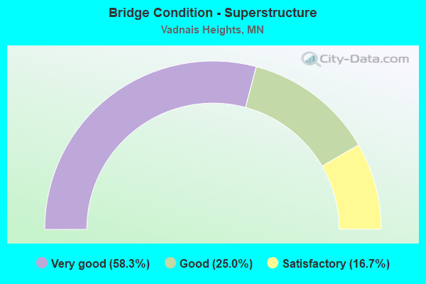
- Bridge Condition - Superstructure
- 58.3%Very good
- 25.0%Good
- 16.7%Satisfactory
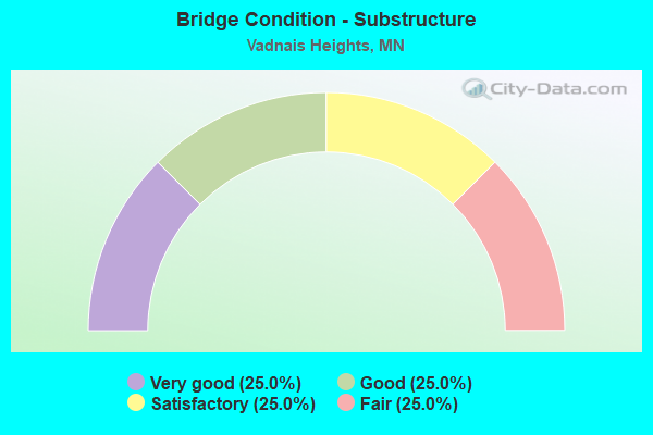
- Bridge Condition - Substructure
- 25.0%Very good
- 25.0%Good
- 25.0%Satisfactory
- 25.0%Fair
Find on map >> Show street view
Structure Number: 62623, Location: 0.1 MI E OF RICE ST (Lat: 45.046725, Lng: -93.104706), Route carried "on" structure: County highway 16, Year Built: 2008, Status: Open, Structure Length: 11.42m (37.47ft), Average Daily Traffic: 3,750 (year 2017), Average Future Daily Traffic: 3,750 (year 2039), Design Load: HL 93, Features Intersected: WEST VADNAIS SWAMP
Minimum Vertical Clearance: 30+ m (98+ ft), Kilometerpoint: 0.000, Lanes on structure: 2, Owner: County Highway Agency, Approaching Roadway Width: 9.8m (32.2ft), Skew: 20 degrees, Material/Design: Prestressed concrete, Design/Construction: Stringer/Multi-beam, Number Of Spans In Main Unit: 5, Length of Maximum Span: 23.6m (77.4ft), Curb-To-Curb Width: 10.4m (34.1ft), Out-to-Out Width: 11.4m (37.4ft)
Condition: Deck: Good, Superstructure: Very good, Substructure: Very good, Operating Rating: 62.7 metric tons, Method Used To Determine Operating Rating: Load Factor (LF), Inventory Rating: 33.6 metric tons, Method Used To Determine Inventory Rating: Load Factor (LF), Structural Evaluation: Equal to present desirable criteria, Deck Geometry: Somewhat better than minimum adequacy, Waterway Adequacy: Equal to present desirable criteria, Approach Roadway Alignment: Somewhat better than minimum adequacy, Designated Inspection Frequency: Every 24 months, Inspection Date: October 2021, Deck Structure Type: Concrete Cast-file-Place, Wearing Surface/Protective System: Wearing Surface: Low Slump Concrete, Deck Protection: Epoxy Coated Reinforcing
Find on map >> Show street view
Structure Number: 62729, Location: 1.4 MI N OF E JCT TH 694 (Lat: 45.056736, Lng: -93.057472), Route carried "on" structure: Interstate 35E, Year Built: 2015, Status: Open, Structure Length: 7.00m (22.97ft), Average Daily Traffic: 33,500 (year 2017), Average Future Daily Traffic: 33,500 (year 2039), Design Load: HL 93, Features Intersected: GOOSE LAKE RD; BNSF RR
Minimum Vertical Clearance: 30+ m (98+ ft), Kilometerpoint: 0.000, Lanes on structure: 2, Lanes under structure: 2, Base Highway Network: Yes, Owner: State Highway Agency, Approaching Roadway Width: 16.6m (54.5ft), Skew: 4 degrees, Material/Design: Prestressed concrete, Design/Construction: Stringer/Multi-beam, Number Of Spans In Main Unit: 2, Length of Maximum Span: 37.6m (123.4ft), Curb-To-Curb Width: 16.6m (54.5ft), Out-to-Out Width: 17.5m (57.4ft)
Condition: Deck: Good, Superstructure: Very good, Substructure: Good, Operating Rating: 45.4 metric tons, Method Used To Determine Operating Rating: Load and Resistance Factor Rating (LRFR) rating reported by rating factor(RF) method using HL-93 loadings, Inventory Rating: 35.0 metric tons, Method Used To Determine Inventory Rating: Load and Resistance Factor Rating (LRFR) rating reported by rating factor(RF) method using HL-93 loadings, Structural Evaluation: Better than present minimum criteria, Deck Geometry: Superior to present desirable criteria, Underclear: Meets minimum limits, Approach Roadway Alignment: Equal to present desirable criteria, Designated Inspection Frequency: Every 24 months, Inspection Date: May 2020, Deck Structure Type: Concrete Cast-file-Place, Wearing Surface/Protective System: Wearing Surface: Monolithic Concrete, Deck Protection: Epoxy Coated Reinforcing
Find on map >> Show street view
Structure Number: 6273, Location: 1.4 MI N OF E JCT TH 694 (Lat: 45.057008, Lng: -93.057172), Route carried "on" structure: Interstate 35E, Year Built: 2015, Status: Open, Structure Length: 6.93m (22.74ft), Average Daily Traffic: 34,500 (year 2019), Truck Traffic: 4%, Average Future Daily Traffic: 33,500 (year 2039), Design Load: HL 93, Features Intersected: GOOSE LAKE RD; BNSF RR
Minimum Vertical Clearance: 30+ m (98+ ft), Kilometerpoint: 0.000, Lanes on structure: 3, Lanes under structure: 2, Base Highway Network: Yes, Owner: State Highway Agency, Approaching Roadway Width: 16.6m (54.5ft), Skew: 25 degrees, Material/Design: Prestressed concrete, Design/Construction: Stringer/Multi-beam, Number Of Spans In Main Unit: 2, Length of Maximum Span: 38.9m (127.6ft), Curb-To-Curb Width: 16.6m (54.5ft), Out-to-Out Width: 17.6m (57.7ft)
Condition: Deck: Good, Superstructure: Very good, Substructure: Good, Operating Rating: 45.4 metric tons, Method Used To Determine Operating Rating: Load and Resistance Factor Rating (LRFR) rating reported by rating factor(RF) method using HL-93 loadings, Inventory Rating: 35.0 metric tons, Method Used To Determine Inventory Rating: Load and Resistance Factor Rating (LRFR) rating reported by rating factor(RF) method using HL-93 loadings, Structural Evaluation: Better than present minimum criteria, Deck Geometry: Equal to present minimum criteria, Underclear: Better than present minimum criteria, Approach Roadway Alignment: Equal to present desirable criteria, Designated Inspection Frequency: Every 24 months, Inspection Date: May 2020, Deck Structure Type: Concrete Cast-file-Place, Wearing Surface/Protective System: Wearing Surface: Monolithic Concrete, Deck Protection: Epoxy Coated Reinforcing
Find on map >> Show street view
Structure Number: 62851, Location: AT JCT TH 694; 61 (Lat: 45.037644, Lng: -93.042122), Route carried "on" structure: Interstate 694, Year Built: 1969, Status: Open, Structure Length: 8.45m (27.72ft), Average Daily Traffic: 48,500 (year 2017), Truck Traffic: 7%, Average Future Daily Traffic: 48,500 (year 2039), Design Load: HS 20+Mod, Features Intersected: TH61
Minimum Vertical Clearance: 30+ m (98+ ft), Kilometerpoint: 0.000, Lanes on structure: 2, Lanes under structure: 4, Base Highway Network: Yes, Owner: State Highway Agency, Approaching Roadway Width: 11.3m (37.1ft), Skew: 3 degrees, Material/Design: Prestressed concrete, Design/Construction: Stringer/Multi-beam, Number Of Spans In Main Unit: 4, Length of Maximum Span: 25.9m (85.0ft), Curb-To-Curb Width: 12.3m (40.4ft), Out-to-Out Width: 13.6m (44.6ft)
Condition: Deck: Good, Superstructure: Satisfactory, Substructure: Fair, Operating Rating: 68.8 metric tons, Method Used To Determine Operating Rating: Load Factor (LF), Inventory Rating: 29.4 metric tons, Method Used To Determine Inventory Rating: Load Factor (LF), Structural Evaluation: Somewhat better than minimum adequacy, Deck Geometry: Better than present minimum criteria, Underclear: Equal to present desirable criteria, Approach Roadway Alignment: Equal to present desirable criteria, Designated Inspection Frequency: Every 24 months, Inspection Date: August 2021, Deck Structure Type: Concrete Cast-file-Place, Wearing Surface/Protective System: Wearing Surface: Low Slump Concrete
Find on map >> Show street view
Structure Number: 62852, Location: AT JCT TH 694; 61 (Lat: 45.037414, Lng: -93.042289), Route carried "on" structure: Interstate 694, Year Built: 1969, Year Reconstructed: 2004, Status: Open, Structure Length: 8.45m (27.72ft), Average Daily Traffic: 47,500 (year 2019), Truck Traffic: 6%, Average Future Daily Traffic: 48,500 (year 2039), Design Load: HS 25 or greater, Features Intersected: TH61
Minimum Vertical Clearance: 30+ m (98+ ft), Kilometerpoint: 0.000, Lanes on structure: 2, Lanes under structure: 4, Base Highway Network: Yes, Owner: State Highway Agency, Approaching Roadway Width: 11.3m (37.1ft), Skew: 3 degrees, Material/Design: Prestressed concrete, Design/Construction: Stringer/Multi-beam, Number Of Spans In Main Unit: 4, Length of Maximum Span: 25.9m (85.0ft), Curb-To-Curb Width: 12.7m (41.7ft), Out-to-Out Width: 20.5m (67.3ft)
Condition: Deck: Good, Superstructure: Satisfactory, Substructure: Satisfactory, Operating Rating: 64.3 metric tons, Method Used To Determine Operating Rating: Load Factor (LF), Inventory Rating: 28.7 metric tons, Method Used To Determine Inventory Rating: Load Factor (LF), Structural Evaluation: Equal to present minimum criteria, Deck Geometry: Better than present minimum criteria, Underclear: Better than present minimum criteria, Approach Roadway Alignment: Equal to present desirable criteria, Designated Inspection Frequency: Every 24 months, Inspection Date: August 2021, Deck Structure Type: Concrete Cast-file-Place, Wearing Surface/Protective System: Wearing Surface: Low Slump Concrete
Find on map >> Show street view
Structure Number: 62895, Location: 1.0 MI N OF E JCT TH 694 (Lat: 45.050319, Lng: -93.058997), Route carried "on" structure: County highway 15, Year Built: 1992, Status: Open, Structure Length: 5.95m (19.52ft), Average Daily Traffic: 18,000 (year 2013), Average Future Daily Traffic: 18,000 (year 2039), Design Load: HS 25 or greater, Features Intersected: I 35E
Minimum Vertical Clearance: 30+ m (98+ ft), Kilometerpoint: 0.000, Lanes on structure: 4, Lanes under structure: 4, Owner: State Highway Agency, Approaching Roadway Width: 28.7m (94.2ft), Skew: 21 degrees, Material/Design: Prestressed concrete, Design/Construction: Stringer/Multi-beam, Number Of Spans In Main Unit: 2, Length of Maximum Span: 29.0m (95.1ft), Curb or Sidewalk Widths: Left: 0.0m, Right: 3.0m (9.8ft), Curb-To-Curb Width: 26.2m (86.0ft), Out-to-Out Width: 32.6m (107.0ft)
Condition: Deck: Good, Superstructure: Good, Substructure: Fair, Operating Rating: 72.0 metric tons, Method Used To Determine Operating Rating: Load Factor (LF), Inventory Rating: 47.2 metric tons, Method Used To Determine Inventory Rating: Load Factor (LF), Structural Evaluation: Somewhat better than minimum adequacy, Deck Geometry: Superior to present desirable criteria, Underclear: Somewhat better than minimum adequacy, Approach Roadway Alignment: Equal to present desirable criteria, Designated Inspection Frequency: Every 24 months, Inspection Date: May 2020, Deck Structure Type: Concrete Cast-file-Place, Wearing Surface/Protective System: Wearing Surface: Low Slump Concrete, Deck Protection: Epoxy Coated Reinforcing
Find on map >> Show street view
Structure Number: 62906, Location: 0.7 MI E OF W JCT TH 694 (Lat: 45.036514, Lng: -93.076653), Route carried "on" structure: County highway 58, Year Built: 2004, Status: Open, Structure Length: 8.07m (26.48ft), Average Daily Traffic: 5,200 (year 2014), Truck Traffic: 10%, Average Future Daily Traffic: 5,200 (year 2039), Design Load: HS 25 or greater, Features Intersected: I 35 E
Minimum Vertical Clearance: 30+ m (98+ ft), Kilometerpoint: 0.000, Lanes on structure: 2, Lanes under structure: 6, Owner: State Highway Agency, Approaching Roadway Width: 15.9m (52.2ft), Material/Design: Steel continuous, Design/Construction: Stringer/Multi-beam, Number Of Spans In Main Unit: 2, Length of Maximum Span: 39.6m (129.9ft), Curb or Sidewalk Widths: Left: 0.0m, Right: 2.4m (7.9ft), Curb-To-Curb Width: 15.9m (52.2ft), Out-to-Out Width: 19.2m (63.0ft)
Condition: Deck: Good, Superstructure: Very good, Substructure: Good, Operating Rating: 87.8 metric tons, Method Used To Determine Operating Rating: Load Factor (LF), Inventory Rating: 52.5 metric tons, Method Used To Determine Inventory Rating: Load Factor (LF), Structural Evaluation: Better than present minimum criteria, Deck Geometry: Superior to present desirable criteria, Underclear: Somewhat better than minimum adequacy, Approach Roadway Alignment: Equal to present desirable criteria, Length Of Structure Improvement: 2.71m (8.89ft), Designated Inspection Frequency: Every 24 months, Inspection Date: May 2020, Bridge Improvement Cost: $999,999,000, Roadway Improvement Cost: $1,000, Total Project Cost: $1,000, Deck Structure Type: Concrete Cast-file-Place, Wearing Surface/Protective System: Wearing Surface: Low Slump Concrete, Deck Protection: Epoxy Coated Reinforcing
Find on map >> Show street view
Structure Number: 62907, Location: AT THE E JCT TH 694; 35E (Lat: 45.037494, Lng: -93.065033), Route carried "on" structure: Interstate 694, Year Built: 2006, Status: Open, Structure Length: 15.51m (50.89ft), Average Daily Traffic: 48,500 (year 2014), Truck Traffic: 5%, Average Future Daily Traffic: 48,500 (year 2039), Design Load: HL 93, Features Intersected: I 35E
Minimum Vertical Clearance: 30+ m (98+ ft), Kilometerpoint: 0.000, Lanes on structure: 3, Lanes under structure: 6, Base Highway Network: Yes, Owner: State Highway Agency, Approaching Roadway Width: 19.7m (64.6ft), Skew: 5 degrees, Material/Design: Steel continuous, Design/Construction: Stringer/Multi-beam, Number Of Spans In Main Unit: 2, Length of Maximum Span: 80.9m (265.4ft), Curb-To-Curb Width: 19.7m (64.6ft), Out-to-Out Width: 20.7m (67.9ft)
Condition: Deck: Good, Superstructure: Good, Substructure: Satisfactory, Operating Rating: 59.2 metric tons, Method Used To Determine Operating Rating: Load Factor (LF), Inventory Rating: 35.6 metric tons, Method Used To Determine Inventory Rating: Load Factor (LF), Structural Evaluation: Equal to present minimum criteria, Deck Geometry: Superior to present desirable criteria, Underclear: Somewhat better than minimum adequacy, Approach Roadway Alignment: Equal to present desirable criteria, Designated Inspection Frequency: Every 24 months, Inspection Date: August 2021, Deck Structure Type: Concrete Cast-file-Place, Wearing Surface/Protective System: Wearing Surface: Low Slump Concrete, Deck Protection: Epoxy Coated Reinforcing
Find on map >> Show street view
Structure Number: 62908, Location: AT THE E JCT TH 694; 35E (Lat: 45.037564, Lng: -93.060858), Route carried "on" structure: Ramp Interstate 199, Year Built: 2006, Status: Open, Structure Length: 11.07m (36.32ft), Average Daily Traffic: 9,000 (year 2004), Truck Traffic: 6%, Average Future Daily Traffic: 9,000 (year 2029), Design Load: HS 25 or greater, Features Intersected: I 694
Minimum Vertical Clearance: 30+ m (98+ ft), Kilometerpoint: 0.000, Lanes on structure: 1, Lanes under structure: 6, Base Highway Network: Yes, Owner: State Highway Agency, Approaching Roadway Width: 7.9m (25.9ft), Skew: 4 degrees, Material/Design: Steel continuous, Design/Construction: Stringer/Multi-beam, Number Of Spans In Main Unit: 2, Length of Maximum Span: 63.0m (206.7ft), Curb-To-Curb Width: 7.9m (25.9ft), Out-to-Out Width: 8.9m (29.2ft)
Condition: Deck: Satisfactory, Superstructure: Very good, Substructure: Satisfactory, Operating Rating: 82.0 metric tons, Method Used To Determine Operating Rating: Load Factor (LF), Inventory Rating: 56.5 metric tons, Method Used To Determine Inventory Rating: Load Factor (LF), Structural Evaluation: Equal to present minimum criteria, Deck Geometry: Equal to present desirable criteria, Underclear: Somewhat better than minimum adequacy, Approach Roadway Alignment: Better than present minimum criteria, Designated Inspection Frequency: Every 24 months, Inspection Date: August 2021, Deck Structure Type: Concrete Cast-file-Place, Wearing Surface/Protective System: Wearing Surface: Low Slump Concrete, Deck Protection: Epoxy Coated Reinforcing
Find on map >> Show street view
Structure Number: 62909, Location: 0.4 MI E OF E JCT TH 35 (Lat: 45.037617, Lng: -93.057839), Route carried "on" structure: City street 107, Year Built: 2006, Status: Open, Structure Length: 11.37m (37.30ft), Average Daily Traffic: 4,500 (year 2014), Average Future Daily Traffic: 4,500 (year 2039), Design Load: HL 93, Features Intersected: I 694; RAMPS
Minimum Vertical Clearance: 30+ m (98+ ft), Kilometerpoint: 0.000, Lanes on structure: 2, Lanes under structure: 9, Owner: State Highway Agency, Approaching Roadway Width: 13.4m (44.0ft), Skew: 2 degrees, Material/Design: Steel continuous, Design/Construction: Stringer/Multi-beam, Number Of Spans In Main Unit: 2, Length of Maximum Span: 57.6m (189.0ft), Curb or Sidewalk Widths: Left: 0.0m, Right: 2.4m (7.9ft), Curb-To-Curb Width: 13.4m (44.0ft), Out-to-Out Width: 16.8m (55.1ft)
Condition: Deck: Good, Superstructure: Good, Substructure: Fair, Operating Rating: 64.5 metric tons, Method Used To Determine Operating Rating: Load Factor (LF), Inventory Rating: 38.7 metric tons, Method Used To Determine Inventory Rating: Load Factor (LF), Structural Evaluation: Somewhat better than minimum adequacy, Deck Geometry: Superior to present desirable criteria, Underclear: Equal to present minimum criteria, Approach Roadway Alignment: Equal to present desirable criteria, Designated Inspection Frequency: Every 24 months, Inspection Date: August 2021, Deck Structure Type: Concrete Cast-file-Place, Wearing Surface/Protective System: Wearing Surface: Low Slump Concrete, Deck Protection: Epoxy Coated Reinforcing
Find on map >> Show street view
Structure Number: 62943, Location: 0.97 MI NW OF JCT TH 35E (Lat: 45.044950, Lng: -93.106297), Route carried "on" structure: County highway 49, Year Built: 2019, Status: Open, Structure Length: 6.13m (20.11ft), Average Daily Traffic: 24,612 (year 2018), Average Future Daily Traffic: 24,612 (year 2038), Design Load: HL 93, Features Intersected: TH 694
Minimum Vertical Clearance: 30+ m (98+ ft), Kilometerpoint: 0.000, Lanes on structure: 4, Lanes under structure: 6, Owner: State Highway Agency, Approaching Roadway Width: 16.5m (54.1ft), Skew: 5 degrees, Material/Design: Prestressed concrete, Design/Construction: Stringer/Multi-beam, Number Of Spans In Main Unit: 2, Length of Maximum Span: 29.4m (96.5ft), Curb or Sidewalk Widths: Left: 3.1m (10.2ft), Right: 3.7m (12.1ft), Curb-To-Curb Width: 16.5m (54.1ft), Out-to-Out Width: 24.0m (78.7ft)
Condition: Deck: Very good, Superstructure: Very good, Substructure: Very good, Operating Rating: 72.6 metric tons, Method Used To Determine Operating Rating: Load and Resistance Factor Rating (LRFR) rating reported by rating factor(RF) method using HL-93 loadings, Inventory Rating: 37.6 metric tons, Method Used To Determine Inventory Rating: Load and Resistance Factor Rating (LRFR) rating reported by rating factor(RF) method using HL-93 loadings, Structural Evaluation: Equal to present desirable criteria, Deck Geometry: Meets minimum limits, Underclear: Somewhat better than minimum adequacy, Approach Roadway Alignment: Equal to present desirable criteria, Designated Inspection Frequency: Every 24 months, Inspection Date: July 2020, Deck Structure Type: Concrete Cast-file-Place, Wearing Surface/Protective System: Wearing Surface: Monolithic Concrete, Deck Protection: Epoxy Coated Reinforcing
Find on map >> Show street view
Structure Number: 62944, Location: 0.96 MI NW OF JCT TH 35E (Lat: 45.044222, Lng: -93.105047), Route carried "on" structure: Ramp Interstate 7612, Year Built: 2020, Status: Open, Structure Length: 7.46m (24.48ft), Average Daily Traffic: 6,040 (year 2018), Truck Traffic: 2%, Average Future Daily Traffic: 6,040 (year 2038), Design Load: HL 93, Features Intersected: I 694
Minimum Vertical Clearance: 30+ m (98+ ft), Kilometerpoint: 0.000, Lanes on structure: 1, Lanes under structure: 7, Base Highway Network: Yes, Owner: State Highway Agency, Approaching Roadway Width: 7.9m (25.9ft), Skew: 4 degrees, Material/Design: Concrete, Design/Construction: Stringer/Multi-beam, Number Of Spans In Main Unit: 2, Length of Maximum Span: 38.6m (126.6ft), Curb-To-Curb Width: 7.9m (25.9ft), Out-to-Out Width: 8.8m (28.9ft)
Condition: Deck: Very good, Superstructure: Very good, Substructure: Very good, Operating Rating: 58.0 metric tons, Method Used To Determine Operating Rating: Load and Resistance Factor Rating (LRFR) rating reported by rating factor(RF) method using HL-93 loadings, Inventory Rating: 35.6 metric tons, Method Used To Determine Inventory Rating: Load and Resistance Factor Rating (LRFR) rating reported by rating factor(RF) method using HL-93 loadings, Structural Evaluation: Equal to present desirable criteria, Deck Geometry: Equal to present desirable criteria, Underclear: Meets minimum limits, Approach Roadway Alignment: Better than present minimum criteria, Designated Inspection Frequency: Every 24 months, Inspection Date: September 2020, Deck Structure Type: Concrete Cast-file-Place, Wearing Surface/Protective System: Wearing Surface: Monolithic Concrete, Deck Protection: Epoxy Coated Reinforcing
Find on map >> Show street view
Structure Number: 8963, Location: 4.0 MI E OF JCT TH 56 (Lat: 43.673575, Lng: -92.790192), Route carried "on" structure: Interstate 90, Year Built: 1959, Status: Open, Structure Length: 1.36m (4.46ft), Average Daily Traffic: 12,611 (year 2019), Truck Traffic: 13%, Average Future Daily Traffic: 12,000 (year 2039), Design Load: H 20, Features Intersected: ROSE CREEK
Minimum Vertical Clearance: 30+ m (98+ ft), Kilometerpoint: 0.000, Lanes on structure: 6, Base Highway Network: Yes, Owner: State Highway Agency, Approaching Roadway Width: 39.0m (128.0ft), Skew: 13 degrees, Material/Design: Concrete, Design/Construction: Culvert, Number Of Spans In Main Unit: 3, Length of Maximum Span: 4.9m (16.1ft)
Condition: Channel: Fair, Culverts: Poor, Operating Rating: 39.2 metric tons, Method Used To Determine Operating Rating: Assigned ratings based on Allowable Stress Design (ASD) reported in metric tons, Inventory Rating: 29.4 metric tons, Method Used To Determine Inventory Rating: Assigned ratings based on Allowable Stress Design (ASD) reported in metric tons, Structural Evaluation: Meets minimum limits, Waterway Adequacy: Equal to present desirable criteria, Approach Roadway Alignment: Equal to present desirable criteria, Length Of Structure Improvement: 0.58m (1.90ft), Designated Inspection Frequency: Every 12 months, Inspection Date: June 2021, Bridge Improvement Cost: $599,000,000, Roadway Improvement Cost: $7,000,000, Total Project Cost: $114,000,000
Find on map >> Show street view
Structure Number: 62729, Location: 1.4 MI N OF E JCT TH 694 (Lat: 45.056736, Lng: -93.057472), Route carried "under" structure: County highway 14, Year Built: 2015, Structure Length: 0. m, Average Daily Traffic: 4,200 (year 2012), Features Intersected: GOOSE LAKE RD; BNSF RR, Facility Carried by Structure: I 35E
Minimum Vertical Clearance: 7.04m (23.10ft), Kilometerpoint: 0.000, Lanes under structure: 2, Material/Design: Prestressed concrete, Design/Construction: Stringer/Multi-beam, Length of Maximum Span: 37.6m (123.4ft)
Find on map >> Show street view
Structure Number: 6273, Location: 1.4 MI N OF E JCT TH 694 (Lat: 45.057008, Lng: -93.057172), Route carried "under" structure: County highway 14, Year Built: 2015, Structure Length: 0. m, Average Daily Traffic: 4,200 (year 2012), Features Intersected: GOOSE LAKE RD; BNSF RR, Facility Carried by Structure: I 35E
Minimum Vertical Clearance: 7.04m (23.10ft), Kilometerpoint: 0.000, Lanes under structure: 2, Material/Design: Prestressed concrete, Design/Construction: Stringer/Multi-beam, Length of Maximum Span: 38.9m (127.6ft)
Find on map >> Show street view
Structure Number: 62822, Location: 0.3 MI E OF JCT TH 61 (Lat: 45.037414, Lng: -93.036164), Route carried "under" structure: Interstate 694, Year Built: 1966, Structure Length: 0. m, Average Daily Traffic: 81,000 (year 2019), Truck Traffic: 7%, Features Intersected: I 694, Facility Carried by Structure: PEDESTRIAN
Minimum Vertical Clearance: 4.91m (16.11ft), Kilometerpoint: 0.000, Lanes on structure: 4, Lanes under structure: 4, Material/Design: Steel, Design/Construction: Girder and Floorbeam System, Length of Maximum Span: 20.2m (66.3ft)
Find on map >> Show street view
Structure Number: 62851, Location: AT JCT TH 694; 61 (Lat: 45.037644, Lng: -93.042122), Route carried "under" structure: US 61, Year Built: 1969, Structure Length: 0. m, Average Daily Traffic: 30,374 (year 2019), Truck Traffic: 4%, Features Intersected: TH61, Facility Carried by Structure: I 694
Minimum Vertical Clearance: 5.49m (18.01ft), Kilometerpoint: 0.000, Lanes on structure: 2, Lanes under structure: 4, Material/Design: Prestressed concrete, Design/Construction: Stringer/Multi-beam, Length of Maximum Span: 25.9m (85.0ft)
Find on map >> Show street view
Structure Number: 62852, Location: AT JCT TH 694; 61 (Lat: 45.037414, Lng: -93.042289), Route carried "under" structure: US 61, Year Built: 1969, Structure Length: 0. m, Average Daily Traffic: 30,374 (year 2019), Truck Traffic: 4%, Features Intersected: TH61, Facility Carried by Structure: I 694
Minimum Vertical Clearance: 5.30m (17.39ft), Kilometerpoint: 0.000, Lanes on structure: 2, Lanes under structure: 4, Material/Design: Prestressed concrete, Design/Construction: Stringer/Multi-beam, Length of Maximum Span: 25.9m (85.0ft)
Find on map >> Show street view
Structure Number: 62895, Location: 1.0 MI N OF E JCT TH 694 (Lat: 45.050319, Lng: -93.058997), Route carried "under" structure: Interstate 35E, Year Built: 1992, Structure Length: 0. m, Average Daily Traffic: 90,000 (year 2019), Truck Traffic: 4%, Features Intersected: I 35E, Facility Carried by Structure: CSAH 15
Minimum Vertical Clearance: 4.97m (16.31ft), Kilometerpoint: 0.000, Lanes on structure: 4, Lanes under structure: 4, Material/Design: Prestressed concrete, Design/Construction: Stringer/Multi-beam, Length of Maximum Span: 29.0m (95.1ft)
Find on map >> Show street view
Structure Number: 62906, Location: 0.7 MI E OF W JCT TH 694 (Lat: 45.036514, Lng: -93.076653), Route carried "under" structure: Interstate 35E, Year Built: 2004, Structure Length: 0. m, Average Daily Traffic: 135,000 (year 2019), Truck Traffic: 4%, Features Intersected: I 35 E, Facility Carried by Structure: CSAH 58
Minimum Vertical Clearance: 5.06m (16.60ft), Kilometerpoint: 0.000, Lanes on structure: 2, Lanes under structure: 6, Material/Design: Steel continuous, Design/Construction: Stringer/Multi-beam, Length of Maximum Span: 39.6m (129.9ft)
Find on map >> Show street view
Structure Number: 62907, Location: AT THE E JCT TH 694; 35E (Lat: 45.037494, Lng: -93.065033), Route carried "under" structure: Interstate 35E, Year Built: 2006, Structure Length: 0. m, Average Daily Traffic: 49,752 (year 2019), Truck Traffic: 4%, Features Intersected: I 35E, Facility Carried by Structure: I 694
Minimum Vertical Clearance: 5.00m (16.40ft), Kilometerpoint: 0.000, Lanes on structure: 3, Lanes under structure: 6, Material/Design: Steel continuous, Design/Construction: Stringer/Multi-beam, Length of Maximum Span: 80.9m (265.4ft)
Find on map >> Show street view
Structure Number: 62908, Location: AT THE E JCT TH 694; 35E (Lat: 45.037564, Lng: -93.060858), Route carried "under" structure: Interstate 694, Year Built: 2006, Structure Length: 0. m, Average Daily Traffic: 95,000 (year 2019), Truck Traffic: 6%, Features Intersected: I 694, Facility Carried by Structure: CON 199
Minimum Vertical Clearance: 4.97m (16.31ft), Kilometerpoint: 0.000, Lanes on structure: 1, Lanes under structure: 6, Material/Design: Steel continuous, Design/Construction: Stringer/Multi-beam, Length of Maximum Span: 63.0m (206.7ft)
Find on map >> Show street view
Structure Number: 62909, Location: 0.4 MI E OF E JCT TH 35 (Lat: 45.037617, Lng: -93.057839), Route carried "under" structure: Interstate 694, Year Built: 2006, Structure Length: 0. m, Average Daily Traffic: 95,000 (year 2019), Truck Traffic: 6%, Features Intersected: I 694; RAMPS, Facility Carried by Structure: MSAS 107
Minimum Vertical Clearance: 5.85m (19.19ft), Kilometerpoint: 0.000, Lanes on structure: 2, Lanes under structure: 7, Material/Design: Steel continuous, Design/Construction: Stringer/Multi-beam, Length of Maximum Span: 57.6m (189.0ft)
Find on map >> Show street view
Structure Number: 62909, Location: 0.4 MI E OF E JCT TH 35 (Lat: 45.037617, Lng: -93.057839), Route carried "under" structure: Ramp Interstate 199, Year Built: 2006, Structure Length: 0. m, Average Daily Traffic: 500 (year 2005), Features Intersected: I 694; RAMPS, Facility Carried by Structure: MSAS 107
Minimum Vertical Clearance: 5.03m (16.50ft), Kilometerpoint: 0.000, Lanes on structure: 2, Lanes under structure: 1, Material/Design: Steel continuous, Design/Construction: Stringer/Multi-beam, Length of Maximum Span: 57.6m (189.0ft)
Find on map >> Show street view
Structure Number: 62909, Location: 0.4 MI E OF E JCT TH 35 (Lat: 45.037617, Lng: -93.057839), Route carried "under" structure: Ramp Interstate 54, Year Built: 2006, Structure Length: 0. m, Average Daily Traffic: 1 (year 2021), Features Intersected: I 694; RAMPS, Facility Carried by Structure: MSAS 107
Minimum Vertical Clearance: 5.58m (18.31ft), Kilometerpoint: 0.000, Lanes under structure: 1, Material/Design: Steel continuous, Design/Construction: Stringer/Multi-beam, Length of Maximum Span: 57.6m (189.0ft)
Find on map >> Show street view
Structure Number: 6291, Location: AT THE E JCT TH 694; 35E (Lat: 45.039172, Lng: -93.062689), Route carried "under" structure: Interstate 35E, Year Built: 2006, Structure Length: 0. m, Average Daily Traffic: 49,752 (year 2019), Truck Traffic: 4%, Features Intersected: I 35E; I 694 WB ON RAMP, Facility Carried by Structure: CON 199
Minimum Vertical Clearance: 8.38m (27.49ft), Kilometerpoint: 0.000, Lanes on structure: 1, Lanes under structure: 6, Material/Design: Steel continuous, Design/Construction: Stringer/Multi-beam, Length of Maximum Span: 48.0m (157.5ft)
Find on map >> Show street view
Structure Number: 6291, Location: AT THE E JCT TH 694; 35E (Lat: 45.039172, Lng: -93.062689), Route carried "under" structure: Ramp Interstate 6401, Year Built: 2006, Structure Length: 0. m, Average Daily Traffic: 5,000 (year 2004), Truck Traffic: 6%, Features Intersected: I 35E; I 694 WB ON RAMP, Facility Carried by Structure: CON 199
Minimum Vertical Clearance: 7.38m (24.21ft), Kilometerpoint: 0.000, Lanes on structure: 1, Lanes under structure: 1, Material/Design: Steel continuous, Design/Construction: Stringer/Multi-beam, Length of Maximum Span: 48.0m (157.5ft)
Find on map >> Show street view
Structure Number: 62943, Location: 0.97 MI NW OF JCT TH 35E (Lat: 45.044950, Lng: -93.106297), Route carried "under" structure: Interstate 694, Year Built: 2019, Structure Length: 0. m, Average Daily Traffic: 85,000 (year 2019), Truck Traffic: 9%, Features Intersected: TH 694, Facility Carried by Structure: CSAH 49
Minimum Vertical Clearance: 5.12m (16.80ft), Kilometerpoint: 0.000, Lanes under structure: 6, Material/Design: Prestressed concrete, Design/Construction: Stringer/Multi-beam, Length of Maximum Span: 29.4m (96.5ft)
Find on map >> Show street view
Structure Number: 62944, Location: 0.96 MI NW OF JCT TH 35E (Lat: 45.044222, Lng: -93.105047), Route carried "under" structure: Interstate 694, Year Built: 2020, Structure Length: 0. m, Average Daily Traffic: 85,000 (year 2019), Truck Traffic: 9%, Features Intersected: I 694, Facility Carried by Structure: CON 7612
Minimum Vertical Clearance: 5.03m (16.50ft), Kilometerpoint: 0.000, Lanes under structure: 7, Material/Design: Concrete, Design/Construction: Stringer/Multi-beam, Length of Maximum Span: 38.6m (126.6ft)