Bridge Statistics for Utica, Michigan (MI)
Condition, Traffic, Stress, Structural Evaluation, Project Costs
- National Bridge Inventory (NBI) Statistics
- 11Number of bridges
- 92ft / 28.5mTotal length
- 536,598Total average daily traffic
- 15,988Total average daily truck traffic
- National Bridge Inventory (NBI) Registered Bridges for Utica
- No street view available for this location
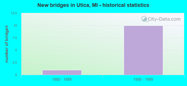
- New bridges - historical statistics
- 11980-1989
- 101990-1999


- Bridge Condition - Deck
- 83.3%Good
- 16.7%Satisfactory

- Bridge Condition - Superstructure
- 50.0%Very good
- 16.7%Good
- 33.3%Satisfactory

- Bridge Condition - Channel
- 50.0%Very good
- 50.0%Good
Find on map >> Show street view
Structure Number: 6014, Location: M-59 WB OV M-53 (Lat: 42.626211, Lng: -83.012692), Route carried "on" structure: State highway 59, Year Built: 1994, Status: Open, Structure Length: 7.19m (23.59ft), Average Daily Traffic: 43,575 (year 2017), Truck Traffic: 1%, Average Future Daily Traffic: 48,150 (year 2037), Design Load: HS 25 or greater, Features Intersected: M-53
Minimum Vertical Clearance: 30.48m (100.00ft), Kilometerpoint: 6.487, Lanes on structure: 5, Lanes under structure: 6, Base Highway Network: Yes (Inventory Route: 80, Subroute: 1), Owner: State Highway Agency, Approaching Roadway Width: 21.9m (71.9ft), Material/Design: Prestressed concrete, Design/Construction: Box Beam or Girders - Multiple, Number Of Spans In Main Unit: 2, Length of Maximum Span: 36.3m (119.1ft), Curb-To-Curb Width: 24.7m (81.0ft), Out-to-Out Width: 25.7m (84.3ft)
Condition: Deck: Good, Superstructure: Satisfactory, Substructure: Good, Operating Rating: 89.1 metric tons, Method Used To Determine Operating Rating: Load Factor (LF) rating reported by rating factor (RF) method using MS18 loading, Inventory Rating: 44.1 metric tons, Method Used To Determine Inventory Rating: Load Factor (LF) rating reported by rating factor (RF) method using MS18 loading, Structural Evaluation: Equal to present minimum criteria, Deck Geometry: Superior to present desirable criteria, Underclear: Equal to present minimum criteria, Approach Roadway Alignment: Equal to present desirable criteria, Designated Inspection Frequency: Every 24 months, Inspection Date: November 2021, Deck Structure Type: Concrete Cast-file-Place, Wearing Surface/Protective System: Wearing Surface: Epoxy Overlay, Deck Protection: Epoxy Coated Reinforcing
Find on map >> Show street view
Structure Number: 6015, Location: M-59 EB OV M-53 (Lat: 42.625500, Lng: -83.012625), Route carried "on" structure: State highway 59, Year Built: 1994, Status: Open, Structure Length: 7.13m (23.39ft), Average Daily Traffic: 43,575 (year 2017), Truck Traffic: 3%, Average Future Daily Traffic: 48,150 (year 2037), Design Load: HS 25 or greater, Features Intersected: M-53
Minimum Vertical Clearance: 30.48m (100.00ft), Kilometerpoint: 1.680, Lanes on structure: 4, Lanes under structure: 6, Base Highway Network: Yes (Inventory Route: 82, Subroute: 2), Owner: State Highway Agency, Approaching Roadway Width: 18.2m (59.7ft), Material/Design: Prestressed concrete, Design/Construction: Box Beam or Girders - Multiple, Number Of Spans In Main Unit: 2, Length of Maximum Span: 35.7m (117.1ft), Curb or Sidewalk Widths: Left: 0.0m, Right: 2.4m (7.9ft), Curb-To-Curb Width: 19.5m (64.0ft), Out-to-Out Width: 23.2m (76.1ft)
Condition: Deck: Good, Superstructure: Satisfactory, Substructure: Good, Operating Rating: 81.3 metric tons, Method Used To Determine Operating Rating: Load Factor (LF) rating reported by rating factor (RF) method using MS18 loading, Inventory Rating: 36.9 metric tons, Method Used To Determine Inventory Rating: Load Factor (LF) rating reported by rating factor (RF) method using MS18 loading, Structural Evaluation: Equal to present minimum criteria, Deck Geometry: Better than present minimum criteria, Underclear: Better than present minimum criteria, Approach Roadway Alignment: Equal to present desirable criteria, Designated Inspection Frequency: Every 24 months, Inspection Date: November 2021, Deck Structure Type: Concrete Cast-file-Place, Wearing Surface/Protective System: Wearing Surface: Epoxy Overlay, Deck Protection: Epoxy Coated Reinforcing
Find on map >> Show street view
Structure Number: 6043, Location: IN UTICA (Lat: 42.625025, Lng: -83.037847), Route carried "on" structure: State highway 59, Year Built: 1994, Status: Open, Structure Length: 2.74m (8.99ft), Average Daily Traffic: 80,406 (year 2007), Truck Traffic: 3%, Average Future Daily Traffic: 123,904 (year 2018), Design Load: HS 25 or greater, Features Intersected: CLINTON RIVER
Minimum Vertical Clearance: 30.48m (100.00ft), Kilometerpoint: 4.407, Lanes on structure: 8, Base Highway Network: Yes (Inventory Route: 80, Subroute: 10), Owner: State Highway Agency, Approaching Roadway Width: 43.9m (144.0ft), Skew: 22 degrees, Material/Design: Prestressed concrete, Design/Construction: Stringer/Multi-beam, Number Of Spans In Main Unit: 2, Length of Maximum Span: 14.0m (45.9ft), Curb-To-Curb Width: 45.6m (149.6ft), Out-to-Out Width: 47.3m (155.2ft)
Condition: Deck: Good, Superstructure: Very good, Substructure: Good, Channel: Good, Operating Rating: 68.0 metric tons, Method Used To Determine Operating Rating: Load Factor (LF) rating reported by rating factor (RF) method using MS18 loading, Inventory Rating: 40.5 metric tons, Method Used To Determine Inventory Rating: Load Factor (LF) rating reported by rating factor (RF) method using MS18 loading, Structural Evaluation: Better than present minimum criteria, Deck Geometry: Superior to present desirable criteria, Waterway Adequacy: Better than present minimum criteria, Approach Roadway Alignment: Better than present minimum criteria, Designated Inspection Frequency: Every 24 months, Inspection Date: November 2021, Deck Structure Type: Concrete Cast-file-Place, Wearing Surface/Protective System: Wearing Surface: Monolithic Concrete, Deck Protection: Epoxy Coated Reinforcing
Find on map >> Show street view
Structure Number: 6044, Location: IN UTICA (Lat: 42.624983, Lng: -83.041275), Route carried "on" structure: City street , Year Built: 1994, Status: Open, Structure Length: 4.36m (14.30ft), Average Daily Traffic: 8,500 (year 1988), Truck Traffic: 3%, Average Future Daily Traffic: 9,775 (year 2008), Design Load: HS 20, Features Intersected: M-59, Facility Carried by Structure: UTICA RD
Minimum Vertical Clearance: 30.48m (100.00ft), Kilometerpoint: 16.772, Lanes on structure: 4, Lanes under structure: 7, Owner: State Highway Agency, Approaching Roadway Width: 16.1m (52.8ft), Material/Design: Prestressed concrete, Design/Construction: Stringer/Multi-beam, Number Of Spans In Main Unit: 2, Length of Maximum Span: 23.7m (77.8ft), Curb or Sidewalk Widths: Left: 1.5m (4.9ft), Right: 1.5m (4.9ft), Curb-To-Curb Width: 15.8m (51.8ft), Out-to-Out Width: 19.6m (64.3ft)
Condition: Deck: Satisfactory, Superstructure: Very good, Substructure: Good, Operating Rating: 54.2 metric tons, Method Used To Determine Operating Rating: Load Factor (LF), Inventory Rating: 32.4 metric tons, Method Used To Determine Inventory Rating: Load Factor (LF), Structural Evaluation: Better than present minimum criteria, Deck Geometry: Meets minimum limits, Underclear: Equal to present minimum criteria, Approach Roadway Alignment: Better than present minimum criteria, Designated Inspection Frequency: Every 24 months, Inspection Date: November 2021, Deck Structure Type: Concrete Cast-file-Place, Wearing Surface/Protective System: Wearing Surface: Monolithic Concrete, Deck Protection: Epoxy Coated Reinforcing
Find on map >> Show street view
Structure Number: 6045, Location: IN UTICA (Lat: 42.624853, Lng: -83.047133), Route carried "on" structure: City street , Year Built: 1994, Status: Open, Structure Length: 3.96m (12.99ft), Average Daily Traffic: 950 (year 1988), Truck Traffic: 6%, Average Future Daily Traffic: 1,093 (year 2008), Design Load: HS 20, Features Intersected: M-59, Facility Carried by Structure: MERRILL RD
Minimum Vertical Clearance: 30.48m (100.00ft), Kilometerpoint: 2.573, Lanes on structure: 2, Lanes under structure: 6, Owner: State Highway Agency, Approaching Roadway Width: 9.7m (31.8ft), Material/Design: Prestressed concrete, Design/Construction: Stringer/Multi-beam, Number Of Spans In Main Unit: 2, Length of Maximum Span: 19.8m (65.0ft), Curb or Sidewalk Widths: Left: 1.5m (4.9ft), Right: 1.5m (4.9ft), Curb-To-Curb Width: 9.7m (31.8ft), Out-to-Out Width: 13.5m (44.3ft)
Condition: Deck: Good, Superstructure: Good, Substructure: Good, Operating Rating: 61.7 metric tons, Method Used To Determine Operating Rating: Load Factor (LF), Inventory Rating: 37.0 metric tons, Method Used To Determine Inventory Rating: Load Factor (LF), Structural Evaluation: Better than present minimum criteria, Underclear: Equal to present minimum criteria, Approach Roadway Alignment: Better than present minimum criteria, Designated Inspection Frequency: Every 24 months, Inspection Date: November 2021, Deck Structure Type: Concrete Cast-file-Place, Wearing Surface/Protective System: Wearing Surface: Monolithic Concrete, Deck Protection: Epoxy Coated Reinforcing
Find on map >> Show street view
Structure Number: 6433, Location: WEST OF VAN DYKE (Lat: 42.625825, Lng: -83.037603), Route carried "on" structure: City street , Year Built: 1988, Status: Open, Structure Length: 3.09m (10.14ft), Average Daily Traffic: 11,186 (year 2008), Average Future Daily Traffic: 12,200 (year 2028), Design Load: HS 20+Mod, Features Intersected: CLINTON RIVER, Facility Carried by Structure: AUBURN RD
Minimum Vertical Clearance: 30.48m (100.00ft), Kilometerpoint: 5.177, Lanes on structure: 2, Owner: City or Municipal Highway Agency, Approaching Roadway Width: 10.1m (33.1ft), Material/Design: Prestressed concrete, Design/Construction: Stringer/Multi-beam, Number Of Spans In Main Unit: 2, Length of Maximum Span: 15.5m (50.9ft), Curb or Sidewalk Widths: Left: 1.5m (4.9ft), Right: 1.5m (4.9ft), Curb-To-Curb Width: 8.5m (27.9ft), Out-to-Out Width: 12.5m (41.0ft)
Condition: Deck: Good, Superstructure: Very good, Substructure: Good, Channel: Very good, Operating Rating: 51.8 metric tons, Method Used To Determine Operating Rating: Load and Resistance Factor Rating (LRFR) rating reported by rating factor(RF) method using HL-93 loadings, Inventory Rating: 40.2 metric tons, Method Used To Determine Inventory Rating: Load and Resistance Factor Rating (LRFR) rating reported by rating factor(RF) method using HL-93 loadings, Structural Evaluation: Better than present minimum criteria, Deck Geometry: High priority of replacement, Waterway Adequacy: Equal to present desirable criteria, Approach Roadway Alignment: Equal to present desirable criteria, Designated Inspection Frequency: Every 24 months, Inspection Date: September 2020, Deck Structure Type: Concrete Cast-file-Place, Wearing Surface/Protective System: Wearing Surface: Bituminous, Deck Protection: Epoxy Coated Reinforcing
Find on map >> Show street view
Structure Number: 6014, Location: M-59 WB OV M-53 (Lat: 42.626211, Lng: -83.012692), Route carried "under" structure: State highway 53, Year Built: 1994, Structure Length: 0. m, Average Daily Traffic: 53,594 (year 2007), Truck Traffic: 4%, Features Intersected: M-53, Facility Carried by Structure: M-59 WB
Minimum Vertical Clearance: 5.28m (17.32ft), Kilometerpoint: 9.315, Lanes on structure: 5, Lanes under structure: 6, Material/Design: Prestressed concrete, Design/Construction: Box Beam or Girders - Multiple, Length of Maximum Span: 36.3m (119.1ft)
Find on map >> Show street view
Structure Number: 6015, Location: M-59 EB OV M-53 (Lat: 42.625500, Lng: -83.012625), Route carried "under" structure: State highway 53, Year Built: 1994, Structure Length: 0. m, Average Daily Traffic: 53,594 (year 2007), Truck Traffic: 4%, Features Intersected: M-53, Facility Carried by Structure: M-59 EB
Minimum Vertical Clearance: 5.11m (16.77ft), Kilometerpoint: 9.235, Lanes on structure: 4, Lanes under structure: 6, Material/Design: Prestressed concrete, Design/Construction: Box Beam or Girders - Multiple, Length of Maximum Span: 35.7m (117.1ft)
Find on map >> Show street view
Structure Number: 6044, Location: IN UTICA (Lat: 42.624983, Lng: -83.041275), Route carried "under" structure: State highway 59, Year Built: 1994, Structure Length: 0. m, Average Daily Traffic: 80,406 (year 2007), Truck Traffic: 3%, Features Intersected: M-59, Facility Carried by Structure: UTICA RD
Minimum Vertical Clearance: 5.44m (17.85ft), Kilometerpoint: 4.131, Lanes on structure: 4, Lanes under structure: 7, Material/Design: Prestressed concrete, Design/Construction: Stringer/Multi-beam, Length of Maximum Span: 23.7m (77.8ft)
Find on map >> Show street view
Structure Number: 6045, Location: IN UTICA (Lat: 42.624853, Lng: -83.047133), Route carried "under" structure: State highway 59, Year Built: 1994, Structure Length: 0. m, Average Daily Traffic: 80,406 (year 2007), Truck Traffic: 3%, Features Intersected: M-59, Facility Carried by Structure: MERRILL RD
Minimum Vertical Clearance: 5.21m (17.09ft), Kilometerpoint: 3.650, Lanes on structure: 2, Lanes under structure: 6, Material/Design: Prestressed concrete, Design/Construction: Stringer/Multi-beam, Length of Maximum Span: 19.8m (65.0ft)
Find on map >> Show street view
Structure Number: 6046, Location: IN UTICA (Lat: 42.625133, Lng: -83.042083), Route carried "under" structure: State highway 59, Year Built: 1994, Structure Length: 0. m, Average Daily Traffic: 80,406 (year 2007), Truck Traffic: 3%, Features Intersected: M-59, Facility Carried by Structure: CONRAIL
Minimum Vertical Clearance: 5.59m (18.34ft), Kilometerpoint: 4.064, Lanes under structure: 7, Material/Design: Steel, Design/Construction: Stringer/Multi-beam, Length of Maximum Span: 26.2m (86.0ft)