Bridge Statistics for Ute, Iowa (IA)
Condition, Traffic, Stress, Structural Evaluation, Project Costs
- National Bridge Inventory (NBI) Statistics
- 16Number of bridges
- 233ft / 71.1mTotal length
- 3,460Total average daily traffic
- 483Total average daily truck traffic
- 3,460Total future (year 2036) average daily traffic
- National Bridge Inventory (NBI) Registered Bridges for Ute
- No street view available for this location
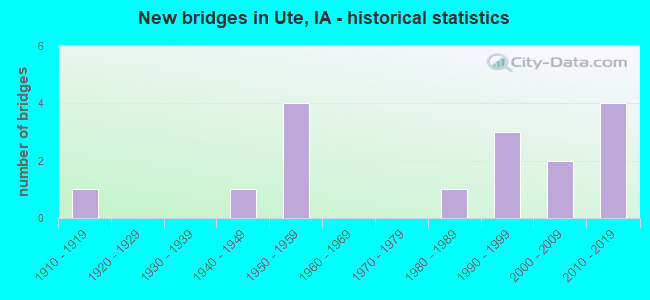
- New bridges - historical statistics
- 11910-1919
- 11940-1949
- 41950-1959
- 11980-1989
- 31990-1999
- 22000-2009
- 42010-2019

- Bridge Condition - Deck
- 35.7%Very good
- 7.1%Good
- 7.1%Satisfactory
- 35.7%Fair
- 7.1%Serious
- 7.1%Failed

- Bridge Condition - Superstructure
- 50.0%Very good
- 7.1%Good
- 21.4%Fair
- 14.3%Poor
- 7.1%Failed

- Bridge Condition - Substructure
- 42.9%Very good
- 7.1%Good
- 14.3%Satisfactory
- 14.3%Fair
- 14.3%Poor
- 7.1%Failed

- Bridge Condition - Channel
- 25.0%Very good
- 43.8%Good
- 18.8%Satisfactory
- 12.5%Fair

- Bridge Condition - Culverts
- 50.0%Excellent
- 50.0%Very good
Find on map >> Show street view
Structure Number: 3679, Location: 3.9 mi. W of IA 183 (Lat: 42.106539, Lng: -95.710492), Route carried "on" structure: State highway 141, Year Built: 1951, Status: Open, Structure Length: 7.47m (24.51ft), Average Daily Traffic: 690 (year 2020), Truck Traffic: 17%, Average Future Daily Traffic: 690 (year 2041), Design Load: H 20, Features Intersected: SOLDIER RIVER
Minimum Vertical Clearance: 30+ m (98+ ft), Kilometerpoint: 51.719, Lanes on structure: 2, Base Highway Network: Yes, Owner: State Highway Agency, Approaching Roadway Width: 11.6m (38.1ft), Skew: 5 degrees, Material/Design: Steel continuous, Design/Construction: Stringer/Multi-beam, Number Of Spans In Main Unit: 3, Length of Maximum Span: 28.7m (94.2ft), Curb-To-Curb Width: 7.9m (25.9ft), Out-to-Out Width: 9.8m (32.2ft)
Condition: Deck: Satisfactory, Superstructure: Good, Substructure: Fair, Channel: Satisfactory, Operating Rating: 39.7 metric tons, Method Used To Determine Operating Rating: Load Factor (LF), Inventory Rating: 23.9 metric tons, Method Used To Determine Inventory Rating: Load Factor (LF), Structural Evaluation: Somewhat better than minimum adequacy, Deck Geometry: Somewhat better than minimum adequacy, Waterway Adequacy: Equal to present minimum criteria, Approach Roadway Alignment: Equal to present desirable criteria, Designated Inspection Frequency: Every 24 months, Inspection Date: June 2021, Deck Structure Type: Concrete Cast-file-Place, Wearing Surface/Protective System: Wearing Surface: Low Slump Concrete
Find on map >> Show street view
Structure Number: 368, Location: 1.6 mi. E of Jct. IA 183 (Lat: 42.051953, Lng: -95.674497), Route carried "on" structure: State highway 141, Year Built: 1957, Status: Open, Structure Length: 6.55m (21.49ft), Average Daily Traffic: 1,330 (year 2020), Truck Traffic: 19%, Average Future Daily Traffic: 1,330 (year 2040), Design Load: H 20, Features Intersected: MIDDLE SOLDIER RIVER
Minimum Vertical Clearance: 30+ m (98+ ft), Kilometerpoint: 60.643, Lanes on structure: 2, Base Highway Network: Yes, Owner: State Highway Agency, Approaching Roadway Width: 14.6m (47.9ft), Skew: 4 degrees, Material/Design: Steel continuous, Design/Construction: Stringer/Multi-beam, Number Of Spans In Main Unit: 3, Length of Maximum Span: 25.0m (82.0ft), Curb-To-Curb Width: 8.5m (27.9ft), Out-to-Out Width: 10.4m (34.1ft)
Condition: Deck: Fair, Superstructure: Fair, Substructure: Fair, Channel: Good, Operating Rating: 44.7 metric tons, Method Used To Determine Operating Rating: Load Factor (LF), Inventory Rating: 26.8 metric tons, Method Used To Determine Inventory Rating: Load Factor (LF), Structural Evaluation: Somewhat better than minimum adequacy, Deck Geometry: Somewhat better than minimum adequacy, Waterway Adequacy: Equal to present minimum criteria, Approach Roadway Alignment: Equal to present desirable criteria, Designated Inspection Frequency: Every 24 months, Inspection Date: October 2020, Deck Structure Type: Concrete Cast-file-Place, Wearing Surface/Protective System: Wearing Surface: Low Slump Concrete
Find on map >> Show street view
Structure Number: 37201, Location: 1.1 mi. S of Jct. IA 141 (Lat: 42.043414, Lng: -95.719456), Route carried "on" structure: State highway 183, Year Built: 1998, Status: Open, Structure Length: 7.19m (23.59ft), Average Daily Traffic: 530 (year 2020), Truck Traffic: 14%, Average Future Daily Traffic: 530 (year 2040), Design Load: HS 20, Features Intersected: SOLDIER RIVER
Minimum Vertical Clearance: 30+ m (98+ ft), Kilometerpoint: 45.586, Lanes on structure: 2, Base Highway Network: Yes, Owner: State Highway Agency, Approaching Roadway Width: 12.2m (40.0ft), Skew: 1 degrees, Material/Design: Prestressed concrete, Design/Construction: Stringer/Multi-beam, Number Of Spans In Main Unit: 3, Length of Maximum Span: 24.7m (81.0ft), Curb-To-Curb Width: 12.2m (40.0ft), Out-to-Out Width: 13.2m (43.3ft)
Condition: Deck: Fair, Superstructure: Very good, Substructure: Very good, Channel: Good, Operating Rating: 64.2 metric tons, Method Used To Determine Operating Rating: Load Factor (LF), Inventory Rating: 38.5 metric tons, Method Used To Determine Inventory Rating: Load Factor (LF), Structural Evaluation: Equal to present desirable criteria, Deck Geometry: Equal to present desirable criteria, Waterway Adequacy: Equal to present minimum criteria, Approach Roadway Alignment: Equal to present minimum criteria, Designated Inspection Frequency: Every 24 months, Inspection Date: October 2020, Deck Structure Type: Concrete Cast-file-Place, Wearing Surface/Protective System: Wearing Surface: Monolithic Concrete, Deck Protection: Epoxy Coated Reinforcing
Find on map >> Show street view
Structure Number: 129691, Location: 084412002 (Lat: 42.075725, Lng: -95.653083), Route carried "on" structure: County highway , Year Built: 2007, Status: Open, Structure Length: 3.90m (12.80ft), Average Daily Traffic: 110 (year 2016), Average Future Daily Traffic: 110 (year 2040), Design Load: HS 20, Features Intersected: MIDDLE SOLDIER RIVER, Facility Carried by Structure: FM
Minimum Vertical Clearance: 30+ m (98+ ft), Kilometerpoint: 22.251, Lanes on structure: 2, Owner: County Highway Agency, Approaching Roadway Width: 9.1m (29.9ft), Skew: 1 degrees, Material/Design: Concrete continuous, Design/Construction: Slab, Number Of Spans In Main Unit: 3, Length of Maximum Span: 14.9m (48.9ft), Curb-To-Curb Width: 9.3m (30.5ft), Out-to-Out Width: 10.1m (33.1ft)
Condition: Deck: Very good, Superstructure: Very good, Substructure: Very good, Channel: Good, Operating Rating: 88.5 metric tons, Method Used To Determine Operating Rating: Load Factor (LF), Inventory Rating: 52.9 metric tons, Method Used To Determine Inventory Rating: Load Factor (LF), Structural Evaluation: Equal to present desirable criteria, Deck Geometry: Equal to present minimum criteria, Waterway Adequacy: Equal to present desirable criteria, Approach Roadway Alignment: Equal to present desirable criteria, Designated Inspection Frequency: Every 24 months, Inspection Date: April 2020, Deck Structure Type: Concrete Cast-file-Place, Wearing Surface/Protective System: Wearing Surface: Monolithic Concrete
Find on map >> Show street view
Structure Number: 129761, Location: 084412904 (Lat: 42.054444, Lng: -95.653222), Route carried "on" structure: County highway , Year Built: 1986, Status: Open, Structure Length: 5.09m (16.70ft), Average Daily Traffic: 70 (year 2016), Average Future Daily Traffic: 70 (year 2040), Design Load: H 20, Features Intersected: EAST SOLDIER RIVER, Facility Carried by Structure: FM
Minimum Vertical Clearance: 30+ m (98+ ft), Kilometerpoint: 19.888, Lanes on structure: 2, Owner: County Highway Agency, Approaching Roadway Width: 7.9m (25.9ft), Skew: 1 degrees, Material/Design: Prestressed concrete, Design/Construction: Stringer/Multi-beam, Number Of Spans In Main Unit: 3, Length of Maximum Span: 18.6m (61.0ft), Curb-To-Curb Width: 7.4m (24.3ft), Out-to-Out Width: 8.4m (27.6ft)
Condition: Deck: Very good, Superstructure: Very good, Substructure: Very good, Channel: Satisfactory, Operating Rating: 63.5 metric tons, Method Used To Determine Operating Rating: Allowable Stress (AS), Inventory Rating: 35.4 metric tons, Method Used To Determine Inventory Rating: Allowable Stress (AS), Structural Evaluation: Equal to present desirable criteria, Deck Geometry: Equal to present minimum criteria, Waterway Adequacy: Equal to present desirable criteria, Approach Roadway Alignment: Equal to present desirable criteria, Designated Inspection Frequency: Every 24 months, Inspection Date: April 2020, Deck Structure Type: Concrete Cast-file-Place, Wearing Surface/Protective System: Wearing Surface: Monolithic Concrete
Find on map >> Show street view
Structure Number: 129771, Location: 08413001 0.6 Mi E NE Cor (Lat: 42.066458, Lng: -95.664444), Route carried "on" structure: County highway , Year Built: 2014, Status: Open, Structure Length: 3.74m (12.27ft), Average Daily Traffic: 25 (year 2016), Average Future Daily Traffic: 25 (year 2040), Features Intersected: MIDDLE SOLDIER RIVER, Facility Carried by Structure: K AVE
Minimum Vertical Clearance: 30+ m (98+ ft), Kilometerpoint: 0.602, Lanes on structure: 2, Owner: County Highway Agency, Approaching Roadway Width: 8.5m (27.9ft), Material/Design: Steel, Design/Construction: Stringer/Multi-beam, Number Of Spans In Main Unit: 1, Number Of Approach Spans: 2, Length of Maximum Span: 12.8m (42.0ft), Curb-To-Curb Width: 7.3m (24.0ft), Out-to-Out Width: 7.3m (24.0ft)
Condition: Deck: Very good, Superstructure: Very good, Substructure: Very good, Channel: Very good, Operating Rating: 29.3 metric tons, Method Used To Determine Operating Rating: Allowable Stress (AS), Inventory Rating: 24.4 metric tons, Method Used To Determine Inventory Rating: Allowable Stress (AS), Structural Evaluation: Equal to present minimum criteria, Deck Geometry: Equal to present minimum criteria, Waterway Adequacy: Superior to present desirable criteria, Approach Roadway Alignment: Equal to present desirable criteria, Designated Inspection Frequency: Every 24 months, Inspection Date: April 2020, Deck Structure Type: Wood or Timber, Wearing Surface/Protective System: Wearing Surface: Wood or Timber
Find on map >> Show street view
Structure Number: 12978, Location: 084413102 (Lat: 42.048572, Lng: -95.671708), Route carried "on" structure: County highway , Year Built: 1957, Status: Posted for load, Structure Length: 4.30m (14.11ft), Average Daily Traffic: 35 (year 2016), Average Future Daily Traffic: 35 (year 2040), Features Intersected: EAST SOLDIER RIVER, Facility Carried by Structure: LOCAL
Minimum Vertical Clearance: 30+ m (98+ ft), Kilometerpoint: 16.438, Lanes on structure: 1, Owner: County Highway Agency, Approaching Roadway Width: 7.9m (25.9ft), Material/Design: Steel, Design/Construction: Truss - Thru, Number Of Spans In Main Unit: 3, Length of Maximum Span: 27.4m (89.9ft), Curb-To-Curb Width: 4.7m (15.4ft), Out-to-Out Width: 5.1m (16.7ft)
Condition: Deck: Fair, Superstructure: Poor, Substructure: Poor, Channel: Fair, Operating Rating: 8.2 metric tons, Method Used To Determine Operating Rating: Allowable Stress (AS), Inventory Rating: 5.0 metric tons, Method Used To Determine Inventory Rating: Allowable Stress (AS), Structural Evaluation: High priority of replacement, Deck Geometry: Better than present minimum criteria, Waterway Adequacy: Equal to present minimum criteria, Approach Roadway Alignment: Better than present minimum criteria, Bridge Posting: Required (Relationship of Operating Rating to Maximum Legal Load: > 39.9% below), Length Of Structure Improvement: 17.50m (57.41ft), Designated Inspection Frequency: Every 24 months, Inspection Date: April 2020, Bridge Improvement Cost: $420,000, Roadway Improvement Cost: $42,000, Deck Structure Type: Wood or Timber, Wearing Surface/Protective System: Wearing Surface: Wood or Timber
Find on map >> Show street view
Structure Number: 249792, Location: 083420403 (Lat: 42.029925, Lng: -95.739483), Route carried "on" structure: County highway , Year Built: 2009, Status: Open, Structure Length: 6.25m (20.51ft), Average Daily Traffic: 10 (year 2016), Average Future Daily Traffic: 10 (year 2039), Design Load: HL 93, Features Intersected: SOLDIER RIVER, Facility Carried by Structure: LOCAL
Minimum Vertical Clearance: 30+ m (98+ ft), Kilometerpoint: 3.861, Lanes on structure: 2, Owner: County Highway Agency, Approaching Roadway Width: 7.3m (24.0ft), Material/Design: Prestressed concrete, Design/Construction: Stringer/Multi-beam, Number Of Spans In Main Unit: 3, Length of Maximum Span: 21.9m (71.9ft), Curb-To-Curb Width: 7.5m (24.6ft), Out-to-Out Width: 8.3m (27.2ft)
Condition: Deck: Very good, Superstructure: Very good, Substructure: Very good, Channel: Very good, Operating Rating: 83.6 metric tons, Method Used To Determine Operating Rating: Load Factor (LF), Inventory Rating: 43.7 metric tons, Method Used To Determine Inventory Rating: Load Factor (LF), Structural Evaluation: Equal to present desirable criteria, Deck Geometry: Equal to present minimum criteria, Waterway Adequacy: Equal to present desirable criteria, Approach Roadway Alignment: Better than present minimum criteria, Designated Inspection Frequency: Every 48 months, Inspection Date: June 2019, Deck Structure Type: Concrete Cast-file-Place, Wearing Surface/Protective System: Wearing Surface: Monolithic Concrete, Deck Protection: Epoxy Coated Reinforcing
Find on map >> Show street view
Structure Number: 250361, Location: 084420106 (Lat: 42.112817, Lng: -95.685936), Route carried "on" structure: County highway , Year Built: 1990, Status: Open, Structure Length: 0.76m (2.49ft), Average Daily Traffic: 10 (year 2016), Average Future Daily Traffic: 10 (year 2041), Design Load: HS 20, Features Intersected: SKUNK CREEK, Facility Carried by Structure: LOCAL
Minimum Vertical Clearance: 30+ m (98+ ft), Kilometerpoint: 19.826, Lanes on structure: 2, Owner: County Highway Agency, Approaching Roadway Width: 7.9m (25.9ft), Material/Design: Concrete, Design/Construction: Channel Beam, Number Of Spans In Main Unit: 1, Length of Maximum Span: 7.3m (24.0ft), Curb-To-Curb Width: 7.3m (24.0ft), Out-to-Out Width: 7.9m (25.9ft)
Condition: Deck: Fair, Superstructure: Fair, Substructure: Satisfactory, Channel: Good, Operating Rating: 41.8 metric tons, Method Used To Determine Operating Rating: Allowable Stress (AS), Inventory Rating: 26.8 metric tons, Method Used To Determine Inventory Rating: Allowable Stress (AS), Structural Evaluation: Somewhat better than minimum adequacy, Deck Geometry: Equal to present minimum criteria, Waterway Adequacy: Better than present minimum criteria, Approach Roadway Alignment: Better than present minimum criteria, Length Of Structure Improvement: 3.00m (9.84ft), Designated Inspection Frequency: Every 24 months, Inspection Date: May 2021, Bridge Improvement Cost: $15,000, Roadway Improvement Cost: $2,000, Deck Structure Type: Concrete Precast Panels, Wearing Surface/Protective System: Wearing Surface: Monolithic Concrete
Find on map >> Show street view
Structure Number: 250441, Location: 084421103 (Lat: 42.106419, Lng: -95.703133), Route carried "on" structure: County highway , Year Built: 2016, Status: Open, Structure Length: 0.73m (2.40ft), Average Daily Traffic: 20 (year 2016), Average Future Daily Traffic: 20 (year 2040), Design Load: HL 93, Features Intersected: TRIB TO SOLDIER RIVER, Facility Carried by Structure: 170TH ST
Minimum Vertical Clearance: 30+ m (98+ ft), Kilometerpoint: 18.224, Lanes on structure: 2, Owner: County Highway Agency, Approaching Roadway Width: 7.9m (25.9ft), Skew: 3 degrees, Material/Design: Concrete continuous, Design/Construction: Culvert, Number Of Spans In Main Unit: 2, Length of Maximum Span: 3.7m (12.1ft)
Condition: Channel: Very good, Culverts: Very good, Operating Rating: 45.0 metric tons, Method Used To Determine Operating Rating: Load and Resistance Factor Rating (LRFR) rating reported by rating factor(RF) method using HL-93 loadings, Inventory Rating: 34.7 metric tons, Method Used To Determine Inventory Rating: Load and Resistance Factor Rating (LRFR) rating reported by rating factor(RF) method using HL-93 loadings, Structural Evaluation: Equal to present desirable criteria, Waterway Adequacy: Equal to present desirable criteria, Approach Roadway Alignment: Better than present minimum criteria, Designated Inspection Frequency: Every 48 months, Inspection Date: May 2020
Find on map >> Show street view
Structure Number: 250452, Location: 084421103 (Lat: 42.106381, Lng: -95.697328), Route carried "on" structure: County highway , Year Built: 1990, Status: Open, Structure Length: 0.76m (2.49ft), Average Daily Traffic: 20 (year 2016), Average Future Daily Traffic: 20 (year 2041), Design Load: HS 20, Features Intersected: TRIB TO SOLDIER RIVER, Facility Carried by Structure: LOCAL
Minimum Vertical Clearance: 30+ m (98+ ft), Kilometerpoint: 18.704, Lanes on structure: 2, Owner: County Highway Agency, Approaching Roadway Width: 7.9m (25.9ft), Material/Design: Concrete, Design/Construction: Channel Beam, Number Of Spans In Main Unit: 1, Length of Maximum Span: 7.3m (24.0ft), Curb-To-Curb Width: 7.3m (24.0ft), Out-to-Out Width: 7.9m (25.9ft)
Condition: Deck: Fair, Superstructure: Fair, Substructure: Satisfactory, Channel: Satisfactory, Operating Rating: 41.8 metric tons, Method Used To Determine Operating Rating: Allowable Stress (AS), Inventory Rating: 26.8 metric tons, Method Used To Determine Inventory Rating: Allowable Stress (AS), Structural Evaluation: Somewhat better than minimum adequacy, Deck Geometry: Equal to present minimum criteria, Waterway Adequacy: Equal to present minimum criteria, Approach Roadway Alignment: Better than present minimum criteria, Length Of Structure Improvement: 3.00m (9.84ft), Designated Inspection Frequency: Every 24 months, Inspection Date: May 2021, Bridge Improvement Cost: $15,000, Roadway Improvement Cost: $2,000, Deck Structure Type: Concrete Precast Panels, Wearing Surface/Protective System: Wearing Surface: Monolithic Concrete
Find on map >> Show street view
Structure Number: 250481, Location: 084422206 (Lat: 42.073769, Lng: -95.725217), Route carried "on" structure: County highway , Year Built: 2019, Status: Open, Structure Length: 0.70m (2.30ft), Average Daily Traffic: 40 (year 2016), Average Future Daily Traffic: 40 (year 2040), Design Load: HL 93, Features Intersected: STREAM, Facility Carried by Structure: SUMAC AVE
Minimum Vertical Clearance: 30+ m (98+ ft), Kilometerpoint: 17.280, Lanes on structure: 2, Owner: County Highway Agency, Approaching Roadway Width: 7.9m (25.9ft), Material/Design: Concrete, Design/Construction: Culvert, Number Of Spans In Main Unit: 2, Length of Maximum Span: 3.0m (9.8ft)
Condition: Channel: Very good, Culverts: Excellent, Operating Rating: 56.4 metric tons, Method Used To Determine Operating Rating: Load and Resistance Factor Rating (LRFR) rating reported by rating factor(RF) method using HL-93 loadings, Inventory Rating: 43.4 metric tons, Method Used To Determine Inventory Rating: Load and Resistance Factor Rating (LRFR) rating reported by rating factor(RF) method using HL-93 loadings, Structural Evaluation: Superior to present desirable criteria, Waterway Adequacy: Better than present minimum criteria, Approach Roadway Alignment: Better than present minimum criteria, Designated Inspection Frequency: Every 24 months, Inspection Date: May 2020
Find on map >> Show street view
Structure Number: 2505, Location: 084422701 (Lat: 42.066639, Lng: -95.716806), Route carried "on" structure: County highway , Year Built: 1957, Year Reconstructed: 1996, Status: Open, Structure Length: 7.74m (25.39ft), Average Daily Traffic: 170 (year 2016), Truck Traffic: 12%, Average Future Daily Traffic: 170 (year 2041), Features Intersected: SOLDIER RIVER, Facility Carried by Structure: FM
Minimum Vertical Clearance: 30+ m (98+ ft), Kilometerpoint: 15.377, Lanes on structure: 2, Owner: County Highway Agency, Approaching Roadway Width: 12.2m (40.0ft), Material/Design: Steel continuous, Design/Construction: Stringer/Multi-beam, Number Of Spans In Main Unit: 3, Length of Maximum Span: 29.6m (97.1ft), Curb-To-Curb Width: 9.1m (29.9ft), Out-to-Out Width: 10.1m (33.1ft)
Condition: Deck: Good, Superstructure: Very good, Substructure: Good, Channel: Good, Operating Rating: 41.5 metric tons, Method Used To Determine Operating Rating: Load Factor (LF), Inventory Rating: 24.9 metric tons, Method Used To Determine Inventory Rating: Load Factor (LF), Structural Evaluation: Equal to present minimum criteria, Deck Geometry: Equal to present minimum criteria, Waterway Adequacy: Equal to present desirable criteria, Approach Roadway Alignment: Better than present minimum criteria, Length Of Structure Improvement: 25.00m (82.02ft), Designated Inspection Frequency: Every 24 months, Inspection Date: May 2021, Bridge Improvement Cost: $15,000, Roadway Improvement Cost: $2,000, Deck Structure Type: Concrete Cast-file-Place, Wearing Surface/Protective System: Wearing Surface: Monolithic Concrete
Find on map >> Show street view
Structure Number: 25053, Location: 084423405 (Lat: 42.052031, Lng: -95.718761), Route carried "on" structure: County highway , Year Built: 1910, Status: Closed, Structure Length: 5.61m (18.41ft), Average Daily Traffic: 80 (year 2016), Average Future Daily Traffic: 80 (year 2036), Features Intersected: UPPER SOLDIER DITCH, Facility Carried by Structure: LOCAL
Minimum Vertical Clearance: 4.37m (14.34ft), Kilometerpoint: 16.010, Lanes on structure: 1, Owner: County Highway Agency, Approaching Roadway Width: 7.3m (24.0ft), Material/Design: Steel, Design/Construction: Truss - Thru, Number Of Spans In Main Unit: 1, Number Of Approach Spans: 2, Length of Maximum Span: 30.5m (100.1ft), Curb-To-Curb Width: 4.8m (15.7ft), Out-to-Out Width: 5.1m (16.7ft)
Condition: Deck: Failed, Superstructure: Failed, Substructure: Failed, Channel: Fair, Deck Geometry: Somewhat better than minimum adequacy, Waterway Adequacy: High priority of corrective action, Approach Roadway Alignment: Somewhat better than minimum adequacy, Bridge Posting: Required (Relationship of Operating Rating to Maximum Legal Load: > 39.9% below), Length Of Structure Improvement: 21.30m (69.88ft), Designated Inspection Frequency: Every 24 months, Inspection Date: June 2016, Bridge Improvement Cost: $510,000, Roadway Improvement Cost: $51,000, Deck Structure Type: Wood or Timber, Wearing Surface/Protective System: Wearing Surface: Wood or Timber
Find on map >> Show street view
Structure Number: 25054, Location: 084423504 (Lat: 42.042439, Lng: -95.710661), Route carried "on" structure: County highway , Year Built: 1949, Status: Posted for load, Structure Length: 5.58m (18.31ft), Average Daily Traffic: 160 (year 2016), Truck Traffic: 13%, Average Future Daily Traffic: 160 (year 2040), Design Load: H 20, Features Intersected: SOLDIER CREEK, Facility Carried by Structure: FM
Minimum Vertical Clearance: 30+ m (98+ ft), Kilometerpoint: 20.769, Lanes on structure: 2, Owner: County Highway Agency, Approaching Roadway Width: 7.9m (25.9ft), Skew: 1 degrees, Material/Design: Steel continuous, Design/Construction: Stringer/Multi-beam, Number Of Spans In Main Unit: 3, Length of Maximum Span: 21.3m (69.9ft), Curb-To-Curb Width: 6.7m (22.0ft), Out-to-Out Width: 7.2m (23.6ft)
Condition: Deck: Serious, Superstructure: Poor, Substructure: Poor, Channel: Good, Operating Rating: 27.0 metric tons, Method Used To Determine Operating Rating: Load Factor (LF), Inventory Rating: 16.1 metric tons, Method Used To Determine Inventory Rating: Load Factor (LF), Structural Evaluation: Meets minimum limits, Deck Geometry: Meets minimum limits, Waterway Adequacy: Better than present minimum criteria, Approach Roadway Alignment: Equal to present desirable criteria, Bridge Posting: Required (Relationship of Operating Rating to Maximum Legal Load: 0.1 - 9.9% below), Length Of Structure Improvement: 21.40m (70.21ft), Designated Inspection Frequency: Every 24 months, Inspection Date: May 2020, Bridge Improvement Cost: $640,000, Roadway Improvement Cost: $64,000, Deck Structure Type: Concrete Cast-file-Place, Wearing Surface/Protective System: Wearing Surface: Monolithic Concrete
Find on map >> Show street view
Structure Number: 250552, Location: 084423518 (Lat: 42.043803, Lng: -95.700883), Route carried "on" structure: County highway , Year Built: 2011, Status: Open, Structure Length: 4.69m (15.39ft), Average Daily Traffic: 160 (year 2016), Average Future Daily Traffic: 160 (year 2040), Design Load: HL 93, Features Intersected: UPPER SOLDIER RIVER, Facility Carried by Structure: TULIP AVE
Minimum Vertical Clearance: 30+ m (98+ ft), Kilometerpoint: 0.707, Lanes on structure: 2, Owner: County Highway Agency, Approaching Roadway Width: 7.9m (25.9ft), Material/Design: Prestressed concrete, Design/Construction: Stringer/Multi-beam, Number Of Spans In Main Unit: 3, Length of Maximum Span: 17.4m (57.1ft), Curb-To-Curb Width: 7.5m (24.6ft), Out-to-Out Width: 8.3m (27.2ft)
Condition: Deck: Very good, Superstructure: Very good, Substructure: Very good, Channel: Good, Operating Rating: 42.1 metric tons, Method Used To Determine Operating Rating: Assigned ratings based on Load and Resistance Factor Design (LRFD) reported by rating factor (RF) using HL93 loadings, Inventory Rating: 32.4 metric tons, Method Used To Determine Inventory Rating: Assigned ratings based on Load and Resistance Factor Design (LRFD) reported by rating factor (RF) using HL93 loadings, Structural Evaluation: Equal to present desirable criteria, Deck Geometry: Somewhat better than minimum adequacy, Waterway Adequacy: Equal to present desirable criteria, Approach Roadway Alignment: Equal to present desirable criteria, Designated Inspection Frequency: Every 48 months, Inspection Date: May 2020, Deck Structure Type: Concrete Cast-file-Place, Wearing Surface/Protective System: Wearing Surface: Monolithic Concrete