Bridge Statistics for Upper Marlboro, Maryland (MD)
Condition, Traffic, Stress, Structural Evaluation, Project Costs
- National Bridge Inventory (NBI) Statistics
- 13Number of bridges
- 79ft / 24.4mTotal length
- $1,444,000Total costs
- 117,709Total average daily traffic
- 8,400Total average daily truck traffic
- 163,090Total future (year 2026) average daily traffic
- National Bridge Inventory (NBI) Registered Bridges for Upper Marlboro
- No street view available for this location
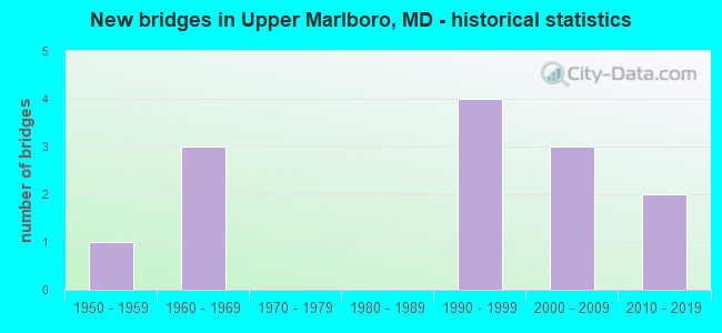
- New bridges - historical statistics
- 11950-1959
- 31960-1969
- 41990-1999
- 32000-2009
- 22010-2019


- Bridge Condition - Deck
- 12.5%Very good
- 62.5%Good
- 25.0%Fair

- Bridge Condition - Superstructure
- 25.0%Very good
- 50.0%Good
- 25.0%Fair

- Bridge Condition - Substructure
- 12.5%Very good
- 50.0%Good
- 12.5%Satisfactory
- 12.5%Fair
- 12.5%Poor

- Bridge Condition - Channel
- 15.4%Very good
- 38.5%Good
- 23.1%Satisfactory
- 23.1%Fair

- Bridge Condition - Culverts
- 60.0%Good
- 20.0%Satisfactory
- 20.0%Fair
Find on map >> Show street view
Structure Number: 10000016001001, Location: 0.41 MILE EAST OF MD 717 (Lat: 38.819828, Lng: -76.746378), Route carried "on" structure: State highway 725, Year Built: 1992, Status: Open, Structure Length: 3.96m (12.99ft), Average Daily Traffic: 15,371 (year 2009), Truck Traffic: 5%, Average Future Daily Traffic: 17,435 (year 2026), Design Load: HS 25 or greater, Features Intersected: WESTERN BRANCH
Minimum Vertical Clearance: 30+ m (98+ ft), Kilometerpoint: 1.915, Lanes on structure: 3, Owner: State Highway Agency, Approaching Roadway Width: 10.7m (35.1ft), Material/Design: Steel continuous, Design/Construction: Stringer/Multi-beam, Number Of Spans In Main Unit: 2, Length of Maximum Span: 18.9m (62.0ft), Curb or Sidewalk Widths: Left: 2.0m (6.6ft), Right: 0.6m (2.0ft), Curb-To-Curb Width: 11.3m (37.1ft), Out-to-Out Width: 13.8m (45.3ft)
Condition: Deck: Good, Superstructure: Good, Substructure: Good, Channel: Good, Operating Rating: 70.7 metric tons, Method Used To Determine Operating Rating: Load Factor (LF), Inventory Rating: 42.2 metric tons, Method Used To Determine Inventory Rating: Load Factor (LF), Structural Evaluation: Better than present minimum criteria, Deck Geometry: High priority of replacement, Waterway Adequacy: Equal to present desirable criteria, Approach Roadway Alignment: Equal to present desirable criteria, Length Of Structure Improvement: 3.96m (12.99ft), Designated Inspection Frequency: Every 24 months, Inspection Date: March 2021, Bridge Improvement Cost: $354,000, Roadway Improvement Cost: $35,000, Total Project Cost: $389,000, Deck Structure Type: Concrete Cast-file-Place, Wearing Surface/Protective System: Wearing Surface: Monolithic Concrete, Deck Protection: Epoxy Coated Reinforcing
Find on map >> Show street view
Structure Number: 10000016001101, Location: ON ANNE ARUNDEL CO LINE (Lat: 38.811181, Lng: -76.711767), Route carried "on" structure: State highway 4, Year Built: 1991, Status: Open, Structure Length: 7.80m (25.59ft), Average Daily Traffic: 49,641 (year 2009), Truck Traffic: 6%, Average Future Daily Traffic: 67,341 (year 2029), Design Load: HS 20, Features Intersected: PATUXENT RIVER
Minimum Vertical Clearance: 30+ m (98+ ft), Kilometerpoint: 0.000, Lanes on structure: 3, Base Highway Network: Yes, Owner: State Highway Agency, Approaching Roadway Width: 13.4m (44.0ft), Material/Design: Steel continuous, Design/Construction: Stringer/Multi-beam, Number Of Spans In Main Unit: 3, Length of Maximum Span: 29.9m (98.1ft), Curb-To-Curb Width: 13.4m (44.0ft), Out-to-Out Width: 14.3m (46.9ft)
Condition: Deck: Good, Superstructure: Good, Substructure: Fair, Channel: Very good, Operating Rating: 49.4 metric tons, Method Used To Determine Operating Rating: Load Factor (LF), Inventory Rating: 29.5 metric tons, Method Used To Determine Inventory Rating: Load Factor (LF), Structural Evaluation: Somewhat better than minimum adequacy, Deck Geometry: Somewhat better than minimum adequacy, Waterway Adequacy: Superior to present desirable criteria, Approach Roadway Alignment: Equal to present desirable criteria, Length Of Structure Improvement: 7.80m (25.59ft), Designated Inspection Frequency: Every 24 months, Underwater Inspection Frequency: Every 48 months, Inspection Date: October 2021, Underwater Inspection Date: April 2021, Bridge Improvement Cost: $722,000, Roadway Improvement Cost: $72,000, Total Project Cost: $794,000, Deck Structure Type: Concrete Cast-file-Place, Wearing Surface/Protective System: Wearing Surface: Monolithic Concrete, Deck Protection: Epoxy Coated Reinforcing
Find on map >> Show street view
Structure Number: 200000P-048201, Location: .3 MI S ST THOMAS CHUR RD (Lat: 38.737192, Lng: -76.719844), Route carried "on" structure: County highway 178, Year Built: 2011, Status: Open, Structure Length: 1.25m (4.10ft), Average Daily Traffic: 72 (year 2016), Truck Traffic: 1%, Average Future Daily Traffic: 120 (year 2036), Design Load: HS 25 or greater, Features Intersected: MATAPONI CREEK, Facility Carried by Structure: FENNO ROAD
Minimum Vertical Clearance: 30+ m (98+ ft), Kilometerpoint: 0.386, Lanes on structure: 2, Owner: County Highway Agency, Approaching Roadway Width: 7.3m (24.0ft), Material/Design: Steel, Design/Construction: Stringer/Multi-beam, Number Of Spans In Main Unit: 1, Length of Maximum Span: 12.5m (41.0ft), Curb or Sidewalk Widths: Left: 0.5m (1.6ft), Right: 0.5m (1.6ft), Curb-To-Curb Width: 7.3m (24.0ft), Out-to-Out Width: 8.3m (27.2ft)
Condition: Deck: Very good, Superstructure: Good, Substructure: Good, Channel: Good, Operating Rating: 67.4 metric tons, Method Used To Determine Operating Rating: Load and Resistance Factor Rating (LRFR) rating reported by rating factor(RF) method using HL-93 loadings, Inventory Rating: 51.8 metric tons, Method Used To Determine Inventory Rating: Load and Resistance Factor Rating (LRFR) rating reported by rating factor(RF) method using HL-93 loadings, Structural Evaluation: Better than present minimum criteria, Deck Geometry: Equal to present minimum criteria, Waterway Adequacy: Equal to present minimum criteria, Approach Roadway Alignment: Equal to present desirable criteria, Designated Inspection Frequency: Every 24 months, Inspection Date: March 2020, Deck Structure Type: Concrete Cast-file-Place, Wearing Surface/Protective System: Wearing Surface: Integral Concrete
Find on map >> Show street view
Structure Number: 200000P-049401, Location: 0.12 MI S OF MD 382 (Lat: 38.730097, Lng: -76.760675), Route carried "on" structure: County highway 140, Year Built: 1956, Status: Open, Structure Length: 1.16m (3.81ft), Average Daily Traffic: 603 (year 2018), Truck Traffic: 5%, Average Future Daily Traffic: 900 (year 2038), Features Intersected: TRIB TO MATAPONI CREEK, Facility Carried by Structure: MOLLY BERRY ROAD
Minimum Vertical Clearance: 30+ m (98+ ft), Kilometerpoint: 0.193, Lanes on structure: 2, Owner: County Highway Agency, Approaching Roadway Width: 7.3m (24.0ft), Skew: 1 degrees, Material/Design: Prestressed concrete, Design/Construction: Stringer/Multi-beam, Number Of Spans In Main Unit: 1, Length of Maximum Span: 10.1m (33.1ft), Curb or Sidewalk Widths: Left: 0.5m (1.6ft), Right: 0.5m (1.6ft), Curb-To-Curb Width: 9.2m (30.2ft), Out-to-Out Width: 10.2m (33.5ft)
Condition: Deck: Fair, Superstructure: Fair, Substructure: Poor, Channel: Fair, Operating Rating: 58.0 metric tons, Method Used To Determine Operating Rating: Load Factor (LF), Inventory Rating: 34.9 metric tons, Method Used To Determine Inventory Rating: Load Factor (LF), Structural Evaluation: Meets minimum limits, Deck Geometry: Equal to present minimum criteria, Waterway Adequacy: Better than present minimum criteria, Approach Roadway Alignment: Equal to present minimum criteria, Length Of Structure Improvement: 0.82m (2.69ft), Designated Inspection Frequency: Every 24 months, Inspection Date: March 2020, Bridge Improvement Cost: $200,000, Roadway Improvement Cost: $50,000, Total Project Cost: $250,000, Wearing Surface/Protective System: Wearing Surface: Bituminous
Find on map >> Show street view
Structure Number: 200000P-049801, Location: 0.29 M S OF ST THMSCH RD (Lat: 38.737911, Lng: -76.720044), Route carried "on" structure: County highway 178, Year Built: 2011, Status: Open, Structure Length: 1.83m (6.00ft), Average Daily Traffic: 72 (year 2016), Truck Traffic: 1%, Average Future Daily Traffic: 120 (year 2036), Design Load: HS 25 or greater, Features Intersected: MATAPONI CREEK, Facility Carried by Structure: FENNO ROAD
Minimum Vertical Clearance: 30+ m (98+ ft), Kilometerpoint: 0.467, Lanes on structure: 2, Owner: County Highway Agency, Approaching Roadway Width: 7.3m (24.0ft), Material/Design: Steel, Design/Construction: Stringer/Multi-beam, Number Of Spans In Main Unit: 1, Length of Maximum Span: 18.3m (60.0ft), Curb or Sidewalk Widths: Left: 0.5m (1.6ft), Right: 0.5m (1.6ft), Curb-To-Curb Width: 7.3m (24.0ft), Out-to-Out Width: 8.3m (27.2ft)
Condition: Deck: Good, Superstructure: Very good, Substructure: Very good, Channel: Fair, Operating Rating: 70.0 metric tons, Method Used To Determine Operating Rating: Load and Resistance Factor Rating (LRFR) rating reported by rating factor(RF) method using HL-93 loadings, Inventory Rating: 54.1 metric tons, Method Used To Determine Inventory Rating: Load and Resistance Factor Rating (LRFR) rating reported by rating factor(RF) method using HL-93 loadings, Structural Evaluation: Equal to present desirable criteria, Deck Geometry: Equal to present minimum criteria, Waterway Adequacy: Better than present minimum criteria, Approach Roadway Alignment: Equal to present desirable criteria, Designated Inspection Frequency: Every 24 months, Inspection Date: March 2020, Deck Structure Type: Concrete Cast-file-Place, Wearing Surface/Protective System: Wearing Surface: Integral Concrete
Find on map >> Show street view
Structure Number: 200000P-050204, Location: 1.61 MILES N OF MD 725 (Lat: 38.839650, Lng: -76.775214), Route carried "on" structure: County highway 99, Year Built: 1964, Status: Posted for load, Structure Length: 1.31m (4.30ft), Average Daily Traffic: 10,535 (year 2018), Truck Traffic: 10%, Average Future Daily Traffic: 15,654 (year 2038), Design Load: HS 20, Features Intersected: CABIN BRANCH, Facility Carried by Structure: BROWN STATION ROAD
Minimum Vertical Clearance: 30+ m (98+ ft), Kilometerpoint: 2.590, Lanes on structure: 2, Owner: County Highway Agency, Approaching Roadway Width: 12.2m (40.0ft), Material/Design: Concrete continuous, Design/Construction: Slab, Number Of Spans In Main Unit: 2, Length of Maximum Span: 6.4m (21.0ft), Curb or Sidewalk Widths: Left: 0.7m (2.3ft), Right: 0.7m (2.3ft), Curb-To-Curb Width: 9.1m (29.9ft), Out-to-Out Width: 11.1m (36.4ft)
Condition: Deck: Fair, Superstructure: Fair, Substructure: Satisfactory, Channel: Fair, Operating Rating: 32.7 metric tons, Method Used To Determine Operating Rating: Load Factor (LF), Inventory Rating: 19.5 metric tons, Method Used To Determine Inventory Rating: Load Factor (LF), Structural Evaluation: Meets minimum limits, Deck Geometry: High priority of corrective action, Waterway Adequacy: Equal to present minimum criteria, Approach Roadway Alignment: Equal to present desirable criteria, Bridge Posting: Required (Relationship of Operating Rating to Maximum Legal Load: 20.0 - 29.9% below), Length Of Structure Improvement: 1.31m (4.30ft), Designated Inspection Frequency: Every 12 months, Inspection Date: March 2021, Bridge Improvement Cost: $10,000, Roadway Improvement Cost: $1,000, Total Project Cost: $11,000, Deck Structure Type: Concrete Cast-file-Place, Wearing Surface/Protective System: Wearing Surface: Bituminous
Find on map >> Show street view
Structure Number: 200000P-050702, Location: 1.1 MI EAST OF OSBORNE RD (Lat: 38.812592, Lng: -76.797125), Route carried "on" structure: County highway 4290, Year Built: 1964, Status: Open, Structure Length: 0.64m (2.10ft), Average Daily Traffic: 854 (year 2016), Truck Traffic: 8%, Average Future Daily Traffic: 1,270 (year 2036), Design Load: HS 20, Features Intersected: FEDERAL SPRING BRANCH, Facility Carried by Structure: WILLIAM BEANES RD
Minimum Vertical Clearance: 30+ m (98+ ft), Kilometerpoint: 1.754, Lanes on structure: 2, Owner: County Highway Agency, Approaching Roadway Width: 12.2m (40.0ft), Skew: 2 degrees, Material/Design: Concrete, Design/Construction: Culvert, Number Of Spans In Main Unit: 2, Length of Maximum Span: 2.7m (8.9ft)
Condition: Channel: Satisfactory, Culverts: Fair, Operating Rating: 61.7 metric tons, Method Used To Determine Operating Rating: Load Factor (LF), Inventory Rating: 35.8 metric tons, Method Used To Determine Inventory Rating: Load Factor (LF), Structural Evaluation: Somewhat better than minimum adequacy, Waterway Adequacy: Equal to present minimum criteria, Approach Roadway Alignment: Equal to present desirable criteria, Designated Inspection Frequency: Every 24 months, Inspection Date: May 2021, Wearing Surface/Protective System: Wearing Surface: Bituminous
Find on map >> Show street view
Structure Number: 200000P-050903, Location: 0.5 MI N OF MARLBORO PIKE (Lat: 38.823097, Lng: -76.767294), Route carried "on" structure: County highway 99, Year Built: 1993, Status: Open, Structure Length: 0.98m (3.22ft), Average Daily Traffic: 11,296 (year 2019), Truck Traffic: 10%, Average Future Daily Traffic: 16,790 (year 2039), Design Load: HS 20, Features Intersected: TRIB TO FEDERAL SPRG BR, Facility Carried by Structure: BROWN STATION RD
Minimum Vertical Clearance: 30+ m (98+ ft), Kilometerpoint: 0.000, Lanes on structure: 2, Owner: County Highway Agency, Approaching Roadway Width: 15.9m (52.2ft), Material/Design: Concrete, Design/Construction: Culvert, Length of Maximum Span: 1.8m (5.9ft), Curb or Sidewalk Widths: Left: 0.0m, Right: 1.2m (3.9ft)
Condition: Channel: Good, Culverts: Good, Operating Rating: 90.2 metric tons, Method Used To Determine Operating Rating: Load Factor (LF), Inventory Rating: 54.0 metric tons, Method Used To Determine Inventory Rating: Load Factor (LF), Structural Evaluation: Better than present minimum criteria, Waterway Adequacy: Better than present minimum criteria, Approach Roadway Alignment: Equal to present desirable criteria, Designated Inspection Frequency: Every 24 months, Inspection Date: May 2021
Find on map >> Show street view
Structure Number: 200000P-051003, Location: .2 MI N OLD MARLBORO PIKE (Lat: 38.821800, Lng: -76.760842), Route carried "on" structure: County highway 4864, Year Built: 1993, Status: Open, Structure Length: 0.70m (2.30ft), Average Daily Traffic: 4,481 (year 2019), Truck Traffic: 5%, Average Future Daily Traffic: 6,660 (year 2039), Design Load: HS 20, Features Intersected: TRIB TO FEDERAL SPRG BR, Facility Carried by Structure: JOHN ROGERS BLVD
Minimum Vertical Clearance: 30+ m (98+ ft), Kilometerpoint: 0.000, Lanes on structure: 2, Owner: County Highway Agency, Approaching Roadway Width: 22.6m (74.1ft), Skew: 1 degrees, Material/Design: Concrete, Design/Construction: Culvert, Length of Maximum Span: 1.5m (4.9ft), Curb or Sidewalk Widths: Left: 1.2m (3.9ft), Right: 1.2m (3.9ft)
Condition: Channel: Good, Culverts: Good, Structural Evaluation: Better than present minimum criteria, Waterway Adequacy: Equal to present minimum criteria, Approach Roadway Alignment: Equal to present desirable criteria, Designated Inspection Frequency: Every 24 months, Inspection Date: May 2021
Find on map >> Show street view
Structure Number: 200000P-051503, Location: 1.0 MI EAST OF US 301 (Lat: 38.761253, Lng: -76.795225), Route carried "on" structure: County highway 3348, Year Built: 1968, Status: Open, Structure Length: 0.73m (2.40ft), Average Daily Traffic: 4,300 (year 2015), Truck Traffic: 3%, Average Future Daily Traffic: 6,390 (year 2035), Features Intersected: SOUTHWEST BRANCH, Facility Carried by Structure: FAIRHAVEN AVENUE
Minimum Vertical Clearance: 30+ m (98+ ft), Kilometerpoint: 0.000, Lanes on structure: 2, Owner: County Highway Agency, Approaching Roadway Width: 14.3m (46.9ft), Skew: 4 degrees, Material/Design: Concrete, Design/Construction: Culvert, Length of Maximum Span: 2.1m (6.9ft), Curb or Sidewalk Widths: Left: 0.0m, Right: 1.8m (5.9ft)
Condition: Channel: Satisfactory, Culverts: Satisfactory, Operating Rating: 32.7 metric tons, Method Used To Determine Operating Rating: Field evaluation and documented engineering judgment, Inventory Rating: 32.7 metric tons, Method Used To Determine Inventory Rating: Field evaluation and documented engineering judgment, Structural Evaluation: Equal to present minimum criteria, Waterway Adequacy: Better than present minimum criteria, Approach Roadway Alignment: Equal to present desirable criteria, Designated Inspection Frequency: Every 24 months, Inspection Date: July 2021
Find on map >> Show street view
Structure Number: 200000P-055602, Location: 0.21 MI N OF MD RTE 214 (Lat: 38.893250, Lng: -76.700731), Route carried "on" structure: County highway , Year Built: 2001, Status: Open, Structure Length: 1.07m (3.51ft), Average Daily Traffic: 223 (year 2021), Truck Traffic: 3%, Average Future Daily Traffic: 300 (year 2041), Design Load: HS 25 or greater, Features Intersected: MOUNT NEBO BRANCH, Facility Carried by Structure: STAN FEY DRIVE
Minimum Vertical Clearance: 30+ m (98+ ft), Kilometerpoint: 0.000, Lanes on structure: 2, Owner: County Highway Agency, Approaching Roadway Width: 8.8m (28.9ft), Skew: 1 degrees, Material/Design: Concrete, Design/Construction: Culvert, Length of Maximum Span: 2.4m (7.9ft)
Condition: Channel: Satisfactory, Culverts: Good, Inventory Rating: 72.1 metric tons, Method Used To Determine Inventory Rating: Load Factor (LF), Structural Evaluation: Better than present minimum criteria, Waterway Adequacy: Better than present minimum criteria, Approach Roadway Alignment: Equal to present desirable criteria, Designated Inspection Frequency: Every 24 months, Inspection Date: May 2021
Find on map >> Show street view
Structure Number: 200000P-059001, Location: 0.5 MILES EAST OF US 301 (Lat: 38.796292, Lng: -76.753128), Route carried "on" structure: County highway 109, Year Built: 2007, Status: Open, Structure Length: 0.79m (2.59ft), Average Daily Traffic: 209 (year 2017), Truck Traffic: 5%, Average Future Daily Traffic: 310 (year 2037), Design Load: HS 25 or greater, Features Intersected: HORSE TAVERN BRANCH, Facility Carried by Structure: CHEW ROAD
Minimum Vertical Clearance: 30+ m (98+ ft), Kilometerpoint: 0.000, Lanes on structure: 2, Owner: County Highway Agency, Approaching Roadway Width: 9.1m (29.9ft), Material/Design: Concrete, Design/Construction: Arch - Deck, Number Of Spans In Main Unit: 1, Length of Maximum Span: 7.3m (24.0ft), Curb-To-Curb Width: 8.8m (28.9ft), Out-to-Out Width: 9.8m (32.2ft)
Condition: Deck: Good, Superstructure: Good, Substructure: Good, Channel: Good, Operating Rating: 67.6 metric tons, Method Used To Determine Operating Rating: Load Factor (LF), Inventory Rating: 53.5 metric tons, Method Used To Determine Inventory Rating: Load Factor (LF), Structural Evaluation: Better than present minimum criteria, Deck Geometry: Equal to present minimum criteria, Waterway Adequacy: Equal to present desirable criteria, Approach Roadway Alignment: Equal to present desirable criteria, Length Of Structure Improvement: 0.79m (2.59ft), Designated Inspection Frequency: Every 24 months, Inspection Date: April 2021, Deck Structure Type: Concrete Cast-file-Place, Wearing Surface/Protective System: Wearing Surface: Integral Concrete, Deck Protection: Epoxy Coated Reinforcing
Find on map >> Show street view
Structure Number: 200000P-059301, Location: 2.91 MILES S OF IS 495 (Lat: 38.840014, Lng: -76.808256), Route carried "on" structure: County highway 974, Year Built: 2009, Status: Open, Structure Length: 2.14m (7.02ft), Average Daily Traffic: 20,052 (year 2019), Truck Traffic: 10%, Average Future Daily Traffic: 29,800 (year 2039), Design Load: HS 20, Features Intersected: CABIN BRANCH, Facility Carried by Structure: RITCHIE MARLBORO R
Minimum Vertical Clearance: 30+ m (98+ ft), Kilometerpoint: 4.103, Lanes on structure: 2, Owner: County Highway Agency, Approaching Roadway Width: 17.4m (57.1ft), Material/Design: Prestressed concrete, Design/Construction: Box Beam or Girders - Multiple, Number Of Spans In Main Unit: 1, Length of Maximum Span: 21.0m (68.9ft), Curb or Sidewalk Widths: Left: 1.6m (5.2ft), Right: 0.0m, Curb-To-Curb Width: 17.0m (55.8ft), Out-to-Out Width: 19.5m (64.0ft)
Condition: Deck: Good, Superstructure: Very good, Substructure: Good, Channel: Very good, Inventory Rating: 75.7 metric tons, Method Used To Determine Inventory Rating: Load Factor (LF), Structural Evaluation: Better than present minimum criteria, Deck Geometry: Superior to present desirable criteria, Waterway Adequacy: Equal to present desirable criteria, Approach Roadway Alignment: Equal to present desirable criteria, Designated Inspection Frequency: Every 24 months, Inspection Date: March 2021, Deck Structure Type: Concrete Cast-file-Place, Wearing Surface/Protective System: Wearing Surface: Integral Concrete