Bridge Statistics for Upland, California (CA)
Condition, Traffic, Stress, Structural Evaluation, Project Costs
- National Bridge Inventory (NBI) Statistics
- 26Number of bridges
- 243ft / 74.3mTotal length
- 2,499,320Total average daily traffic
- 147,720Total average daily truck traffic
- National Bridge Inventory (NBI) Registered Bridges for Upland
- No street view available for this location
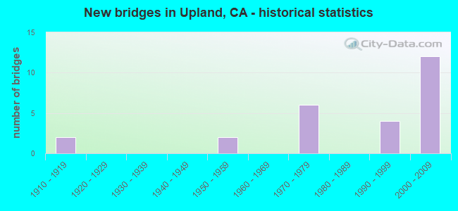
- New bridges - historical statistics
- 21910-1919
- 21950-1959
- 61970-1979
- 41990-1999
- 122000-2009
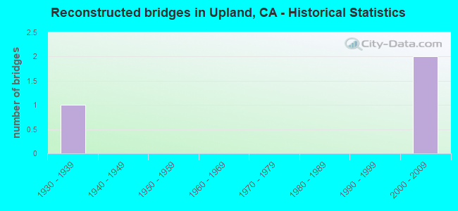
- Reconstructed bridges - Historical Statistics
- 11930-1939
- 01940-1949
- 01950-1959
- 01960-1969
- 01970-1979
- 01980-1989
- 01990-1999
- 22000-2009

- Bridge Condition - Deck
- 87.5%Good
- 12.5%Fair
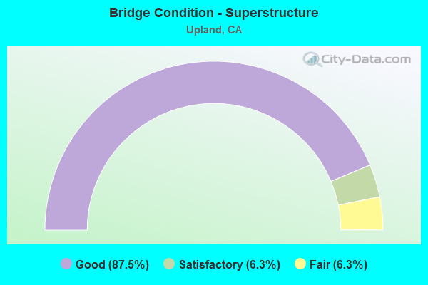
- Bridge Condition - Superstructure
- 87.5%Good
- 6.3%Satisfactory
- 6.3%Fair
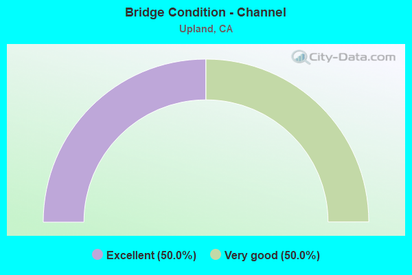
- Bridge Condition - Channel
- 50.0%Excellent
- 50.0%Very good
Find on map >> Show street view
Structure Number: 54 0444, Location: 08-SBD-010-3.75-UPL (Lat: 34.087661, Lng: -117.646250), Route carried "on" structure: City street , Year Built: 1970, Status: Open, Structure Length: 6.09m (19.98ft), Average Daily Traffic: 3,700 (year 2019), Truck Traffic: 2%, Average Future Daily Traffic: 5,200 (year 2041), Design Load: HS 20, Features Intersected: INTERSTATE 10, Facility Carried by Structure: SULTANA AVENUE
Minimum Vertical Clearance: 30+ m (98+ ft), Kilometerpoint: 0.000, Lanes on structure: 2, Lanes under structure: 11, Owner: State Highway Agency, Approaching Roadway Width: 12.2m (40.0ft), Material/Design: Prestressed concrete continuous, Design/Construction: Box Beam or Girders - Multiple, Number Of Spans In Main Unit: 2, Length of Maximum Span: 31.7m (104.0ft), Curb or Sidewalk Widths: Left: 1.5m (4.9ft), Right: 1.5m (4.9ft), Curb-To-Curb Width: 12.2m (40.0ft), Out-to-Out Width: 15.8m (51.8ft)
Condition: Deck: Good, Superstructure: Good, Substructure: Good, Operating Rating: 48.6 metric tons, Method Used To Determine Operating Rating: Load and Resistance Factor Rating (LRFR) rating reported by rating factor(RF) method using HL-93 loadings, Inventory Rating: 34.3 metric tons, Method Used To Determine Inventory Rating: Load and Resistance Factor Rating (LRFR) rating reported by rating factor(RF) method using HL-93 loadings, Structural Evaluation: Better than present minimum criteria, Deck Geometry: Equal to present minimum criteria, Underclear: Meets minimum limits, Approach Roadway Alignment: Equal to present desirable criteria, Designated Inspection Frequency: Every 24 months, Inspection Date: May 2021, Deck Structure Type: Concrete Cast-file-Place
Find on map >> Show street view
Structure Number: 54 0445, Location: 08-SBD-083-11.10-UPL (Lat: 34.087128, Lng: -117.650858), Route carried "on" structure: State highway 83, Year Built: 1970, Status: Open, Structure Length: 5.61m (18.41ft), Average Daily Traffic: 34,500 (year 2020), Truck Traffic: 5%, Average Future Daily Traffic: 51,008 (year 2041), Design Load: HS 20, Features Intersected: INTERSTATE 10
Minimum Vertical Clearance: 30+ m (98+ ft), Kilometerpoint: 11.100, Lanes on structure: 7, Lanes under structure: 11, Base Highway Network: Yes (, Subroute: 1), Owner: State Highway Agency, Approaching Roadway Width: 29.7m (97.4ft), Skew: 30 degrees, Material/Design: Prestressed concrete continuous, Design/Construction: Box Beam or Girders - Multiple, Number Of Spans In Main Unit: 2, Length of Maximum Span: 30.5m (100.1ft), Curb or Sidewalk Widths: Left: 1.5m (4.9ft), Right: 1.5m (4.9ft), Curb-To-Curb Width: 29.7m (97.4ft), Out-to-Out Width: 49.4m (162.1ft)
Condition: Deck: Fair, Superstructure: Good, Substructure: Good, Operating Rating: 47.3 metric tons, Method Used To Determine Operating Rating: Load and Resistance Factor Rating (LRFR) rating reported by rating factor(RF) method using HL-93 loadings, Inventory Rating: 31.4 metric tons, Method Used To Determine Inventory Rating: Load and Resistance Factor Rating (LRFR) rating reported by rating factor(RF) method using HL-93 loadings, Structural Evaluation: Better than present minimum criteria, Deck Geometry: Equal to present minimum criteria, Underclear: High priority of corrective action, Approach Roadway Alignment: Equal to present desirable criteria, Designated Inspection Frequency: Every 24 months, Inspection Date: November 2021, Deck Structure Type: Concrete Cast-file-Place
Find on map >> Show street view
Structure Number: 54 0446, Location: 08-SBD-010-2.92-UPL (Lat: 34.087561, Lng: -117.660858), Route carried "on" structure: City street , Year Built: 1970, Status: Open, Structure Length: 5.24m (17.19ft), Average Daily Traffic: 14,000 (year 2019), Truck Traffic: 2%, Average Future Daily Traffic: 20,000 (year 2041), Design Load: HS 20, Features Intersected: INTERSTATE 10, Facility Carried by Structure: SAN ANTONIO AVENUE
Minimum Vertical Clearance: 30+ m (98+ ft), Kilometerpoint: 0.000, Lanes on structure: 2, Lanes under structure: 10, Owner: State Highway Agency, Approaching Roadway Width: 19.5m (64.0ft), Material/Design: Prestressed concrete continuous, Design/Construction: Box Beam or Girders - Multiple, Number Of Spans In Main Unit: 2, Length of Maximum Span: 25.9m (85.0ft), Curb or Sidewalk Widths: Left: 1.5m (4.9ft), Right: 1.5m (4.9ft), Curb-To-Curb Width: 19.5m (64.0ft), Out-to-Out Width: 23.2m (76.1ft)
Condition: Deck: Good, Superstructure: Good, Substructure: Good, Operating Rating: 46.0 metric tons, Method Used To Determine Operating Rating: Load and Resistance Factor Rating (LRFR) rating reported by rating factor(RF) method using HL-93 loadings, Inventory Rating: 34.0 metric tons, Method Used To Determine Inventory Rating: Load and Resistance Factor Rating (LRFR) rating reported by rating factor(RF) method using HL-93 loadings, Structural Evaluation: Better than present minimum criteria, Deck Geometry: Superior to present desirable criteria, Underclear: High priority of corrective action, Approach Roadway Alignment: Equal to present desirable criteria, Designated Inspection Frequency: Every 48 months, Inspection Date: May 2021, Deck Structure Type: Concrete Cast-file-Place
Find on map >> Show street view
Structure Number: 54 1140L, Location: 08-SBD-210-12.91-FNA (Lat: 34.136544, Lng: -117.471239), Route carried "on" structure: State highway 210, Year Built: 2000, Status: Open, Structure Length: 4.04m (13.25ft), Average Daily Traffic: 60,000 (year 2019), Truck Traffic: 3%, Average Future Daily Traffic: 71,412 (year 2041), Design Load: HS 20+Mod, Features Intersected: BEECH AVENUE
Minimum Vertical Clearance: 30+ m (98+ ft), Kilometerpoint: 12.910, Lanes on structure: 5, Lanes under structure: 5, Base Highway Network: Yes, Owner: State Highway Agency, Approaching Roadway Width: 30.8m (101.0ft), Material/Design: Prestressed concrete, Design/Construction: Box Beam or Girders - Multiple, Number Of Spans In Main Unit: 1, Length of Maximum Span: 40.4m (132.5ft), Curb-To-Curb Width: 30.8m (101.0ft), Out-to-Out Width: 31.8m (104.3ft)
Condition: Deck: Fair, Superstructure: Good, Substructure: Good, Operating Rating: 54.1 metric tons, Method Used To Determine Operating Rating: Assigned rating based on Load Factor Design (LFD) reported in metric tons, Inventory Rating: 32.4 metric tons, Method Used To Determine Inventory Rating: Assigned rating based on Load Factor Design (LFD) reported in metric tons, Structural Evaluation: Better than present minimum criteria, Deck Geometry: Superior to present desirable criteria, Underclear: Superior to present desirable criteria, Approach Roadway Alignment: Equal to present desirable criteria, Designated Inspection Frequency: Every 24 months, Inspection Date: Febuary 2021, Deck Structure Type: Concrete Cast-file-Place
Find on map >> Show street view
Structure Number: 54 1143, Location: 08-SBD-210-0.85-UPL (Lat: 34.132681, Lng: -117.681194), Route carried "on" structure: City street , Year Built: 2001, Status: Open, Structure Length: 8.98m (29.46ft), Average Daily Traffic: 7,200 (year 2016), Truck Traffic: 5%, Average Future Daily Traffic: 8,400 (year 2040), Design Load: HS 20+Mod, Features Intersected: STATE ROUTE 210, Facility Carried by Structure: BENSON AVENUE
Minimum Vertical Clearance: 30+ m (98+ ft), Kilometerpoint: 0.000, Lanes on structure: 4, Lanes under structure: 9, Owner: State Highway Agency, Approaching Roadway Width: 19.2m (63.0ft), Skew: 23 degrees, Material/Design: Prestressed concrete continuous, Design/Construction: Box Beam or Girders - Multiple, Number Of Spans In Main Unit: 2, Length of Maximum Span: 46.3m (151.9ft), Curb or Sidewalk Widths: Left: 1.8m (5.9ft), Right: 1.8m (5.9ft), Curb-To-Curb Width: 19.2m (63.0ft), Out-to-Out Width: 26.7m (87.6ft)
Condition: Deck: Good, Superstructure: Good, Substructure: Good, Operating Rating: 54.1 metric tons, Method Used To Determine Operating Rating: Assigned rating based on Load Factor Design (LFD) reported in metric tons, Inventory Rating: 32.4 metric tons, Method Used To Determine Inventory Rating: Assigned rating based on Load Factor Design (LFD) reported in metric tons, Structural Evaluation: Better than present minimum criteria, Deck Geometry: Equal to present minimum criteria, Underclear: Somewhat better than minimum adequacy, Approach Roadway Alignment: Equal to present desirable criteria, Designated Inspection Frequency: Every 24 months, Inspection Date: July 2020, Deck Structure Type: Concrete Cast-file-Place
Find on map >> Show street view
Structure Number: 54 1144, Location: 08-SBD-210-1.50-UPL (Lat: 34.135061, Lng: -117.670531), Route carried "on" structure: City street , Year Built: 2001, Status: Open, Structure Length: 8.04m (26.38ft), Average Daily Traffic: 25,000 (year 2014), Truck Traffic: 5%, Average Future Daily Traffic: 27,000 (year 2040), Design Load: HS 20+Mod, Features Intersected: STATE ROUTE 210, Facility Carried by Structure: MOUNTAIN AVENUE
Minimum Vertical Clearance: 30+ m (98+ ft), Kilometerpoint: 0.000, Lanes on structure: 6, Lanes under structure: 9, Base Highway Network: Yes, Owner: State Highway Agency, Approaching Roadway Width: 26.4m (86.6ft), Material/Design: Prestressed concrete continuous, Design/Construction: Box Beam or Girders - Multiple, Number Of Spans In Main Unit: 2, Length of Maximum Span: 42.6m (139.8ft), Curb or Sidewalk Widths: Left: 1.8m (5.9ft), Right: 1.8m (5.9ft), Curb-To-Curb Width: 26.4m (86.6ft), Out-to-Out Width: 30.6m (100.4ft)
Condition: Deck: Good, Superstructure: Satisfactory, Substructure: Good, Operating Rating: 54.1 metric tons, Method Used To Determine Operating Rating: Assigned rating based on Load Factor Design (LFD) reported in metric tons, Inventory Rating: 32.4 metric tons, Method Used To Determine Inventory Rating: Assigned rating based on Load Factor Design (LFD) reported in metric tons, Structural Evaluation: Equal to present minimum criteria, Deck Geometry: Equal to present minimum criteria, Underclear: Somewhat better than minimum adequacy, Approach Roadway Alignment: Equal to present desirable criteria, Designated Inspection Frequency: Every 24 months, Inspection Date: July 2020, Deck Structure Type: Concrete Cast-file-Place
Find on map >> Show street view
Structure Number: 54 1145, Location: 08-SBD-210-2.04-UPL (Lat: 34.134978, Lng: -117.661067), Route carried "on" structure: City street , Year Built: 1998, Status: Open, Structure Length: 7.53m (24.70ft), Average Daily Traffic: 5,200 (year 2015), Truck Traffic: 5%, Average Future Daily Traffic: 6,600 (year 2040), Design Load: HS 20+Mod, Features Intersected: STATE ROUTE 210, Facility Carried by Structure: SAN ANTONIO AVENUE
Minimum Vertical Clearance: 30+ m (98+ ft), Kilometerpoint: 0.000, Lanes on structure: 4, Lanes under structure: 9, Owner: State Highway Agency, Approaching Roadway Width: 19.5m (64.0ft), Material/Design: Prestressed concrete continuous, Design/Construction: Box Beam or Girders - Multiple, Number Of Spans In Main Unit: 2, Length of Maximum Span: 38.7m (127.0ft), Curb or Sidewalk Widths: Left: 1.8m (5.9ft), Right: 1.8m (5.9ft), Curb-To-Curb Width: 19.5m (64.0ft), Out-to-Out Width: 23.7m (77.8ft)
Condition: Deck: Good, Superstructure: Good, Substructure: Good, Operating Rating: 54.1 metric tons, Method Used To Determine Operating Rating: Assigned rating based on Load Factor Design (LFD) reported in metric tons, Inventory Rating: 32.4 metric tons, Method Used To Determine Inventory Rating: Assigned rating based on Load Factor Design (LFD) reported in metric tons, Structural Evaluation: Better than present minimum criteria, Deck Geometry: Better than present minimum criteria, Underclear: Meets minimum limits, Approach Roadway Alignment: Equal to present desirable criteria, Designated Inspection Frequency: Every 24 months, Inspection Date: July 2020, Deck Structure Type: Concrete Cast-file-Place
Find on map >> Show street view
Structure Number: 54 1146, Location: 08-SBD-210-2.59-UPL (Lat: 34.134978, Lng: -117.651561), Route carried "on" structure: City street , Year Built: 1999, Status: Open, Structure Length: 6.31m (20.70ft), Average Daily Traffic: 13,000 (year 2016), Truck Traffic: 5%, Average Future Daily Traffic: 18,000 (year 2040), Design Load: HS 20+Mod, Features Intersected: STATE ROUTE 210, Facility Carried by Structure: EUCLID AVENUE
Minimum Vertical Clearance: 30+ m (98+ ft), Kilometerpoint: 0.000, Lanes on structure: 4, Lanes under structure: 8, Base Highway Network: Yes, Owner: State Highway Agency, Approaching Roadway Width: 21.4m (70.2ft), Skew: 20 degrees, Material/Design: Prestressed concrete continuous, Design/Construction: Box Beam or Girders - Multiple, Number Of Spans In Main Unit: 2, Length of Maximum Span: 31.6m (103.7ft), Curb or Sidewalk Widths: Left: 1.5m (4.9ft), Right: 1.5m (4.9ft), Curb-To-Curb Width: 21.4m (70.2ft), Out-to-Out Width: 79.7m (261.5ft)
Condition: Deck: Good, Superstructure: Good, Substructure: Good, Operating Rating: 54.1 metric tons, Method Used To Determine Operating Rating: Assigned rating based on Load Factor Design (LFD) reported in metric tons, Inventory Rating: 32.4 metric tons, Method Used To Determine Inventory Rating: Assigned rating based on Load Factor Design (LFD) reported in metric tons, Structural Evaluation: Better than present minimum criteria, Deck Geometry: Superior to present desirable criteria, Underclear: Equal to present minimum criteria, Approach Roadway Alignment: Equal to present desirable criteria, Designated Inspection Frequency: Every 24 months, Inspection Date: July 2020, Deck Structure Type: Concrete Cast-file-Place
Find on map >> Show street view
Structure Number: 54 1147L, Location: 08-SBD-210-3.47-UPL (Lat: 34.134889, Lng: -117.635931), Route carried "on" structure: State highway 210, Year Built: 2001, Status: Open, Structure Length: 4.40m (14.44ft), Average Daily Traffic: 92,500 (year 2017), Truck Traffic: 5%, Average Future Daily Traffic: 120,000 (year 2040), Design Load: HS 20+Mod, Features Intersected: CAMPUS AVENUE
Minimum Vertical Clearance: 30+ m (98+ ft), Kilometerpoint: 3.470, Lanes on structure: 4, Lanes under structure: 5, Base Highway Network: Yes (Inventory Route: 2, Subroute: 1), Owner: State Highway Agency, Approaching Roadway Width: 21.6m (70.9ft), Material/Design: Prestressed concrete, Design/Construction: Box Beam or Girders - Multiple, Number Of Spans In Main Unit: 1, Length of Maximum Span: 44.0m (144.4ft), Curb-To-Curb Width: 21.6m (70.9ft), Out-to-Out Width: 22.7m (74.5ft)
Condition: Deck: Good, Superstructure: Good, Substructure: Good, Operating Rating: 54.1 metric tons, Method Used To Determine Operating Rating: Assigned rating based on Load Factor Design (LFD) reported in metric tons, Inventory Rating: 32.4 metric tons, Method Used To Determine Inventory Rating: Assigned rating based on Load Factor Design (LFD) reported in metric tons, Structural Evaluation: Better than present minimum criteria, Deck Geometry: Better than present minimum criteria, Underclear: Somewhat better than minimum adequacy, Approach Roadway Alignment: Equal to present desirable criteria, Designated Inspection Frequency: Every 24 months, Inspection Date: July 2020, Deck Structure Type: Concrete Cast-file-Place
Find on map >> Show street view
Structure Number: 54 1147R, Location: 08-SBD-210-3.47-UPL (Lat: 34.134625, Lng: -117.635956), Route carried "on" structure: State highway 210, Year Built: 2001, Status: Open, Structure Length: 4.40m (14.44ft), Average Daily Traffic: 92,500 (year 2017), Truck Traffic: 5%, Average Future Daily Traffic: 120,000 (year 2040), Design Load: HS 20+Mod, Features Intersected: CAMPUS AVENUE
Minimum Vertical Clearance: 30+ m (98+ ft), Kilometerpoint: 3.470, Lanes on structure: 4, Lanes under structure: 5, Base Highway Network: Yes (Inventory Route: 2, Subroute: 1), Owner: State Highway Agency, Approaching Roadway Width: 21.6m (70.9ft), Material/Design: Prestressed concrete, Design/Construction: Box Beam or Girders - Multiple, Number Of Spans In Main Unit: 1, Length of Maximum Span: 44.0m (144.4ft), Curb-To-Curb Width: 21.6m (70.9ft), Out-to-Out Width: 22.7m (74.5ft)
Condition: Deck: Good, Superstructure: Good, Substructure: Good, Operating Rating: 54.1 metric tons, Method Used To Determine Operating Rating: Assigned rating based on Load Factor Design (LFD) reported in metric tons, Inventory Rating: 32.4 metric tons, Method Used To Determine Inventory Rating: Assigned rating based on Load Factor Design (LFD) reported in metric tons, Structural Evaluation: Better than present minimum criteria, Deck Geometry: Better than present minimum criteria, Underclear: Somewhat better than minimum adequacy, Approach Roadway Alignment: Equal to present desirable criteria, Designated Inspection Frequency: Every 24 months, Inspection Date: July 2020, Deck Structure Type: Concrete Cast-file-Place
Find on map >> Show street view
Structure Number: 54 1186, Location: 08-SBD-010-1.23-MCL (Lat: 34.085136, Lng: -117.689872), Route carried "on" structure: Interstate 10, Year Built: 2000, Status: Open, Structure Length: 5.76m (18.90ft), Average Daily Traffic: 263,000 (year 2017), Truck Traffic: 7%, Average Future Daily Traffic: 275,000 (year 2039), Design Load: HS 20+Mod, Features Intersected: CENTRAL AVENUE
Minimum Vertical Clearance: 30+ m (98+ ft), Kilometerpoint: 1.230, Lanes on structure: 10, Lanes under structure: 10, Base Highway Network: Yes (, Subroute: 1), Owner: State Highway Agency, Approaching Roadway Width: 49.6m (162.7ft), Skew: 32 degrees, Material/Design: Prestressed concrete continuous, Design/Construction: Box Beam or Girders - Multiple, Number Of Spans In Main Unit: 2, Length of Maximum Span: 28.8m (94.5ft), Curb-To-Curb Width: 49.6m (162.7ft), Out-to-Out Width: 51.5m (169.0ft)
Condition: Deck: Good, Superstructure: Good, Substructure: Good, Operating Rating: 54.1 metric tons, Method Used To Determine Operating Rating: Assigned rating based on Load Factor Design (LFD) reported in metric tons, Inventory Rating: 32.4 metric tons, Method Used To Determine Inventory Rating: Assigned rating based on Load Factor Design (LFD) reported in metric tons, Structural Evaluation: Better than present minimum criteria, Deck Geometry: Superior to present desirable criteria, Underclear: Somewhat better than minimum adequacy, Approach Roadway Alignment: Equal to present desirable criteria, Designated Inspection Frequency: Every 24 months, Inspection Date: May 2021, Deck Structure Type: Concrete Cast-file-Place
Find on map >> Show street view
Structure Number: 54 1187, Location: 08-SBD-010-2.37-UPL (Lat: 34.087067, Lng: -117.670425), Route carried "on" structure: Interstate 10, Year Built: 2000, Status: Open, Structure Length: 5.02m (16.47ft), Average Daily Traffic: 263,000 (year 2017), Truck Traffic: 7%, Average Future Daily Traffic: 280,000 (year 2039), Design Load: HS 20+Mod, Features Intersected: MOUNTAIN AVENUE
Minimum Vertical Clearance: 30+ m (98+ ft), Kilometerpoint: 2.370, Lanes on structure: 10, Lanes under structure: 8, Base Highway Network: Yes (, Subroute: 1), Owner: State Highway Agency, Approaching Roadway Width: 49.8m (163.4ft), Skew: 30 degrees, Material/Design: Concrete continuous, Design/Construction: Box Beam or Girders - Multiple, Number Of Spans In Main Unit: 2, Length of Maximum Span: 25.1m (82.3ft), Curb-To-Curb Width: 49.8m (163.4ft), Out-to-Out Width: 51.5m (169.0ft)
Condition: Deck: Good, Superstructure: Good, Substructure: Good, Operating Rating: 54.1 metric tons, Method Used To Determine Operating Rating: Assigned rating based on Load Factor Design (LFD) reported in metric tons, Inventory Rating: 32.4 metric tons, Method Used To Determine Inventory Rating: Assigned rating based on Load Factor Design (LFD) reported in metric tons, Structural Evaluation: Better than present minimum criteria, Deck Geometry: Superior to present desirable criteria, Underclear: Equal to present minimum criteria, Approach Roadway Alignment: Equal to present desirable criteria, Designated Inspection Frequency: Every 24 months, Inspection Date: May 2021, Deck Structure Type: Concrete Cast-file-Place
Find on map >> Show street view
Structure Number: 54C0467, Location: 0.4 MI W OF CENTRAL AVE (Lat: 34.099453, Lng: -117.697136), Route carried "on" structure: County highway , Year Built: 1958, Status: Open, Structure Length: 0.73m (2.40ft), Average Daily Traffic: 6,220 (year 2006), Truck Traffic: 3%, Average Future Daily Traffic: 10,168 (year 2037), Design Load: HS 20, Features Intersected: SAN ANTONIO CREEK CHAN, Facility Carried by Structure: ARROW ROUTE
Minimum Vertical Clearance: 30+ m (98+ ft), Kilometerpoint: 0.000, Lanes on structure: 2, Owner: County Highway Agency, Approaching Roadway Width: 12.8m (42.0ft), Material/Design: Steel, Design/Construction: Stringer/Multi-beam, Number Of Spans In Main Unit: 1, Length of Maximum Span: 6.7m (22.0ft), Curb or Sidewalk Widths: Left: 0.5m (1.6ft), Right: 0.5m (1.6ft), Curb-To-Curb Width: 15.7m (51.5ft), Out-to-Out Width: 17.5m (57.4ft)
Condition: Deck: Good, Superstructure: Good, Substructure: Good, Channel: Excellent, Operating Rating: 47.6 metric tons, Method Used To Determine Operating Rating: Load and Resistance Factor Rating (LRFR) rating reported by rating factor(RF) method using HL-93 loadings, Inventory Rating: 36.6 metric tons, Method Used To Determine Inventory Rating: Load and Resistance Factor Rating (LRFR) rating reported by rating factor(RF) method using HL-93 loadings, Structural Evaluation: Better than present minimum criteria, Deck Geometry: Superior to present desirable criteria, Waterway Adequacy: Superior to present desirable criteria, Approach Roadway Alignment: Equal to present desirable criteria, Designated Inspection Frequency: Every 48 months, Inspection Date: May 2018, Deck Structure Type: Concrete Cast-file-Place, Wearing Surface/Protective System: Wearing Surface: Bituminous
Find on map >> Show street view
Structure Number: 54C0717, Location: JUST W/O MONTE VISTA AVE (Lat: 34.106692, Lng: -117.699028), Route carried "on" structure: City street , Year Built: 1914, Year Reconstructed: 1937, Status: Open, Structure Length: 0.70m (2.30ft), Average Daily Traffic: 21,500 (year 2015), Truck Traffic: 3%, Average Future Daily Traffic: 41,000 (year 2040), Features Intersected: SAN ANTONIO OVERFLOW, Facility Carried by Structure: FOOTHILL BLVD
Minimum Vertical Clearance: 30+ m (98+ ft), Kilometerpoint: 0.000, Lanes on structure: 5, Base Highway Network: Yes, Owner: City or Municipal Highway Agency, Approaching Roadway Width: 23.3m (76.4ft), Material/Design: Concrete, Design/Construction: Tee Beam, Number Of Spans In Main Unit: 1, Length of Maximum Span: 6.4m (21.0ft), Curb or Sidewalk Widths: Left: 0.3m (1.0ft), Right: 0.0m, Curb-To-Curb Width: 23.3m (76.4ft), Out-to-Out Width: 25.0m (82.0ft)
Condition: Deck: Good, Superstructure: Good, Substructure: Good, Channel: Very good, Operating Rating: 28.8 metric tons, Method Used To Determine Operating Rating: Field evaluation and documented engineering judgment, Inventory Rating: 17.2 metric tons, Method Used To Determine Inventory Rating: Field evaluation and documented engineering judgment, Structural Evaluation: Meets minimum limits, Deck Geometry: Better than present minimum criteria, Waterway Adequacy: Equal to present desirable criteria, Approach Roadway Alignment: Equal to present desirable criteria, Designated Inspection Frequency: Every 24 months, Inspection Date: May 2021, Deck Structure Type: Concrete Cast-file-Place, Wearing Surface/Protective System: Wearing Surface: Bituminous
Find on map >> Show street view
Structure Number: 54C0718, Location: 0.15 MI E MONTE VISTA AVE (Lat: 34.106808, Lng: -117.695808), Route carried "on" structure: City street , Year Built: 1914, Year Reconstructed: 2013, Status: Open, Structure Length: 0.70m (2.30ft), Average Daily Traffic: 21,500 (year 2015), Truck Traffic: 3%, Average Future Daily Traffic: 43,500 (year 2040), Features Intersected: SAN ANTONIO OVERFLOW, Facility Carried by Structure: FOOTHILL BLVD
Minimum Vertical Clearance: 30+ m (98+ ft), Kilometerpoint: 0.000, Lanes on structure: 4, Base Highway Network: Yes, Owner: City or Municipal Highway Agency, Approaching Roadway Width: 18.2m (59.7ft), Skew: 30 degrees, Material/Design: Concrete, Design/Construction: Tee Beam, Number Of Spans In Main Unit: 1, Length of Maximum Span: 6.4m (21.0ft), Curb-To-Curb Width: 18.2m (59.7ft), Out-to-Out Width: 28.8m (94.5ft)
Condition: Deck: Good, Superstructure: Fair, Substructure: Good, Channel: Very good, Operating Rating: 28.2 metric tons, Method Used To Determine Operating Rating: Field evaluation and documented engineering judgment, Inventory Rating: 16.8 metric tons, Method Used To Determine Inventory Rating: Field evaluation and documented engineering judgment, Structural Evaluation: Meets minimum limits, Deck Geometry: Somewhat better than minimum adequacy, Waterway Adequacy: Equal to present desirable criteria, Approach Roadway Alignment: Equal to present desirable criteria, Designated Inspection Frequency: Every 24 months, Inspection Date: May 2021, Deck Structure Type: Concrete Cast-file-Place, Wearing Surface/Protective System: Wearing Surface: Bituminous
Find on map >> Show street view
Structure Number: 54C0719, Location: 0.18 MI E MONTE VISTA AVE (Lat: 34.106642, Lng: -117.695436), Route carried "on" structure: City street , Year Built: 1958, Year Reconstructed: 2013, Status: Open, Structure Length: 0.70m (2.30ft), Average Daily Traffic: 21,500 (year 2015), Truck Traffic: 3%, Average Future Daily Traffic: 43,000 (year 2040), Design Load: H 20, Features Intersected: SAN ANTONIO OVERFLOW, Facility Carried by Structure: FOOTHILL BLVD
Minimum Vertical Clearance: 30+ m (98+ ft), Kilometerpoint: 0.000, Lanes on structure: 4, Base Highway Network: Yes, Owner: City or Municipal Highway Agency, Approaching Roadway Width: 18.2m (59.7ft), Material/Design: Steel, Design/Construction: Stringer/Multi-beam, Number Of Spans In Main Unit: 1, Length of Maximum Span: 6.4m (21.0ft), Curb-To-Curb Width: 18.2m (59.7ft), Out-to-Out Width: 36.4m (119.4ft)
Condition: Deck: Good, Superstructure: Good, Substructure: Good, Channel: Excellent, Operating Rating: 70.0 metric tons, Method Used To Determine Operating Rating: Load Factor (LF), Inventory Rating: 42.1 metric tons, Method Used To Determine Inventory Rating: Load Factor (LF), Structural Evaluation: Better than present minimum criteria, Deck Geometry: Somewhat better than minimum adequacy, Waterway Adequacy: Equal to present desirable criteria, Approach Roadway Alignment: Equal to present desirable criteria, Designated Inspection Frequency: Every 24 months, Inspection Date: May 2021, Deck Structure Type: Concrete Cast-file-Place, Wearing Surface/Protective System: Wearing Surface: Bituminous
Find on map >> Show street view
Structure Number: 54 0444, Location: 08-SBD-010-3.75-UPL (Lat: 34.087661, Lng: -117.646250), Route carried "under" structure: Interstate 10, Year Built: 1970, Structure Length: 0. m, Average Daily Traffic: 263,000 (year 2017), Truck Traffic: 7%, Features Intersected: INTERSTATE 10, Facility Carried by Structure: SULTANA AVENUE
Minimum Vertical Clearance: 5.03m (16.50ft), Kilometerpoint: 3.750, Lanes on structure: 2, Lanes under structure: 11, Material/Design: Prestressed concrete continuous, Design/Construction: Box Beam or Girders - Multiple, Length of Maximum Span: 31.7m (104.0ft)
Find on map >> Show street view
Structure Number: 54 0445, Location: 08-SBD-083-11.10-UPL (Lat: 34.087128, Lng: -117.650858), Route carried "under" structure: Interstate 10, Year Built: 1970, Structure Length: 0. m, Average Daily Traffic: 243,000 (year 2020), Truck Traffic: 7%, Features Intersected: INTERSTATE 10, Facility Carried by Structure: STATE ROUTE 83
Minimum Vertical Clearance: 5.05m (16.57ft), Kilometerpoint: 3.470, Lanes on structure: 7, Lanes under structure: 11, Material/Design: Prestressed concrete continuous, Design/Construction: Box Beam or Girders - Multiple, Length of Maximum Span: 30.5m (100.1ft)
Find on map >> Show street view
Structure Number: 54 0446, Location: 08-SBD-010-2.92-UPL (Lat: 34.087561, Lng: -117.660858), Route carried "under" structure: Interstate 10, Year Built: 1970, Structure Length: 0. m, Average Daily Traffic: 263,000 (year 2017), Truck Traffic: 7%, Features Intersected: INTERSTATE 10, Facility Carried by Structure: SAN ANTONIO AVENUE
Minimum Vertical Clearance: 5.08m (16.67ft), Kilometerpoint: 2.920, Lanes on structure: 2, Lanes under structure: 10, Material/Design: Prestressed concrete continuous, Design/Construction: Box Beam or Girders - Multiple, Length of Maximum Span: 25.9m (85.0ft)
Find on map >> Show street view
Structure Number: 54 1143, Location: 08-SBD-210-0.85-UPL (Lat: 34.132681, Lng: -117.681194), Route carried "under" structure: State highway 210, Year Built: 2001, Structure Length: 0. m, Average Daily Traffic: 178,000 (year 2017), Truck Traffic: 5%, Features Intersected: STATE ROUTE 210, Facility Carried by Structure: BENSON AVENUE
Minimum Vertical Clearance: 5.11m (16.77ft), Kilometerpoint: 0.850, Lanes on structure: 4, Lanes under structure: 9, Material/Design: Prestressed concrete continuous, Design/Construction: Box Beam or Girders - Multiple, Length of Maximum Span: 46.3m (151.9ft)
Find on map >> Show street view
Structure Number: 54 1144, Location: 08-SBD-210-1.50-UPL (Lat: 34.135061, Lng: -117.670531), Route carried "under" structure: State highway 210, Year Built: 2001, Structure Length: 0. m, Average Daily Traffic: 178,000 (year 2017), Truck Traffic: 5%, Features Intersected: STATE ROUTE 210, Facility Carried by Structure: MOUNTAIN AVENUE
Minimum Vertical Clearance: 5.15m (16.90ft), Kilometerpoint: 1.500, Lanes on structure: 6, Lanes under structure: 9, Material/Design: Prestressed concrete continuous, Design/Construction: Box Beam or Girders - Multiple, Length of Maximum Span: 42.6m (139.8ft)
Find on map >> Show street view
Structure Number: 54 1145, Location: 08-SBD-210-2.04-UPL (Lat: 34.134978, Lng: -117.661067), Route carried "under" structure: State highway 210, Year Built: 1998, Structure Length: 0. m, Average Daily Traffic: 181,000 (year 2017), Truck Traffic: 5%, Features Intersected: STATE ROUTE 210, Facility Carried by Structure: SAN ANTONIO AVENUE
Minimum Vertical Clearance: 5.36m (17.59ft), Kilometerpoint: 2.040, Lanes on structure: 4, Lanes under structure: 9, Material/Design: Prestressed concrete continuous, Design/Construction: Box Beam or Girders - Multiple, Length of Maximum Span: 38.7m (127.0ft)
Find on map >> Show street view
Structure Number: 54 1146, Location: 08-SBD-210-2.59-UPL (Lat: 34.134978, Lng: -117.651561), Route carried "under" structure: State highway 210, Year Built: 1999, Structure Length: 0. m, Average Daily Traffic: 181,000 (year 2017), Truck Traffic: 5%, Features Intersected: STATE ROUTE 210, Facility Carried by Structure: EUCLID AVENUE
Minimum Vertical Clearance: 5.31m (17.42ft), Kilometerpoint: 2.590, Lanes on structure: 4, Lanes under structure: 8, Material/Design: Prestressed concrete continuous, Design/Construction: Box Beam or Girders - Multiple, Length of Maximum Span: 31.6m (103.7ft)
Find on map >> Show street view
Structure Number: 54 1147L, Location: 08-SBD-210-3.47-UPL (Lat: 34.134889, Lng: -117.635931), Route carried "under" structure: City street , Year Built: 2001, Structure Length: 0. m, Average Daily Traffic: 14,000 (year 2014), Truck Traffic: 5%, Features Intersected: CAMPUS AVENUE, Facility Carried by Structure: STATE ROUTE 210 WB
Minimum Vertical Clearance: 4.69m (15.39ft), Kilometerpoint: 0.000, Lanes on structure: 4, Lanes under structure: 5, Material/Design: Prestressed concrete, Design/Construction: Box Beam or Girders - Multiple, Length of Maximum Span: 44.0m (144.4ft)
Find on map >> Show street view
Structure Number: 54 1147R, Location: 08-SBD-210-3.47-UPL (Lat: 34.134625, Lng: -117.635956), Route carried "under" structure: City street , Year Built: 2001, Structure Length: 0. m, Average Daily Traffic: 14,000 (year 2014), Truck Traffic: 5%, Features Intersected: CAMPUS AVENUE, Facility Carried by Structure: STATE ROUTE 210 EB
Minimum Vertical Clearance: 5.77m (18.93ft), Kilometerpoint: 0.000, Lanes on structure: 4, Lanes under structure: 5, Material/Design: Prestressed concrete, Design/Construction: Box Beam or Girders - Multiple, Length of Maximum Span: 44.0m (144.4ft)
Find on map >> Show street view
Structure Number: 54 1187, Location: 08-SBD-010-2.37-UPL (Lat: 34.087067, Lng: -117.670425), Route carried "under" structure: City street , Year Built: 2000, Structure Length: 0. m, Average Daily Traffic: 40,000 (year 2019), Truck Traffic: 5%, Features Intersected: MOUNTAIN AVENUE, Facility Carried by Structure: INTERSTATE 10
Minimum Vertical Clearance: 4.65m (15.26ft), Kilometerpoint: 0.000, Lanes on structure: 10, Lanes under structure: 8, Material/Design: Concrete continuous, Design/Construction: Box Beam or Girders - Multiple, Length of Maximum Span: 25.1m (82.3ft)