Bridge Statistics for Uniondale, New York (NY)
Condition, Traffic, Stress, Structural Evaluation, Project Costs
- National Bridge Inventory (NBI) Statistics
- 18Number of bridges
- 82ft / 25.1mTotal length
- $58,738,000Total costs
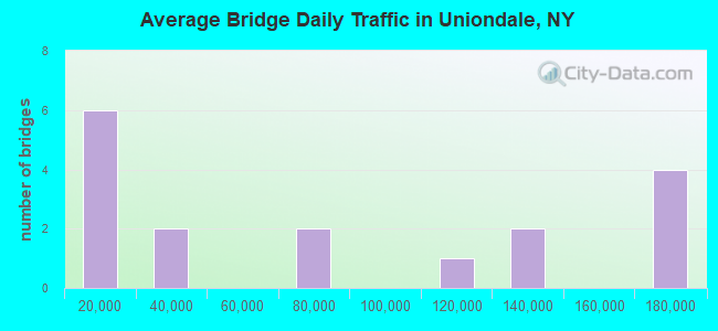
- 1,339,683Total average daily traffic
- 4,582Total average daily truck traffic
- National Bridge Inventory (NBI) Registered Bridges for Uniondale
- No street view available for this location
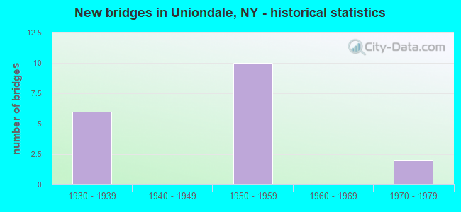
- New bridges - historical statistics
- 61930-1939
- 101950-1959
- 21970-1979
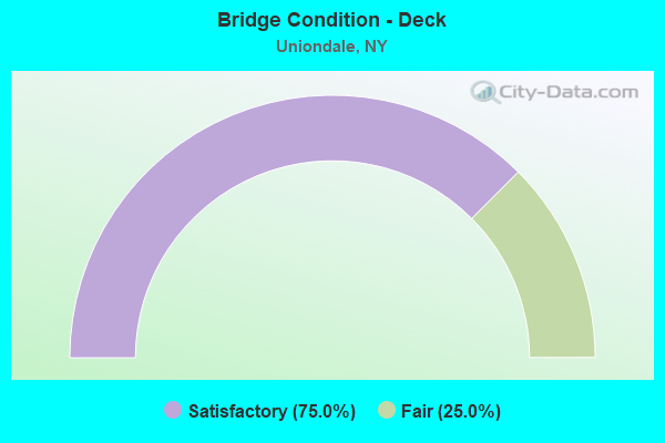
- Bridge Condition - Deck
- 75.0%Satisfactory
- 25.0%Fair
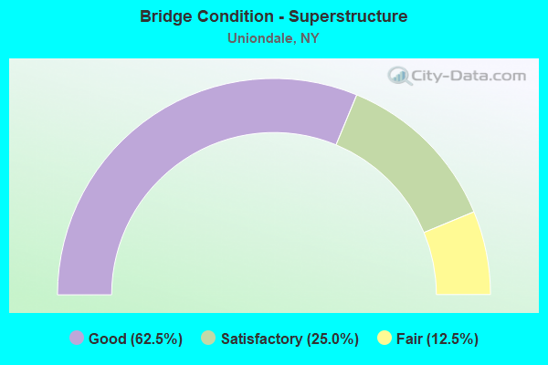
- Bridge Condition - Superstructure
- 62.5%Good
- 25.0%Satisfactory
- 12.5%Fair
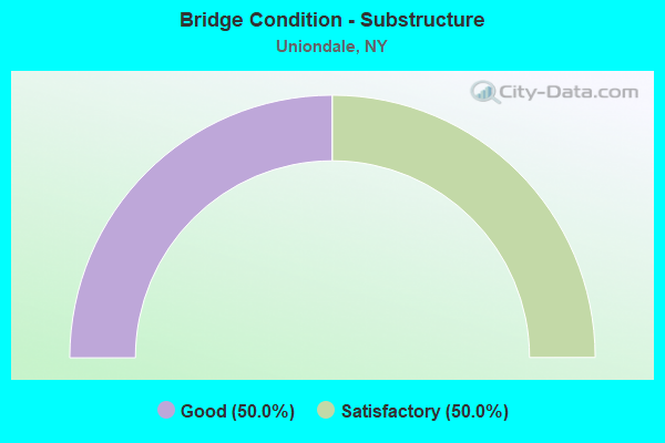
- Bridge Condition - Substructure
- 50.0%Good
- 50.0%Satisfactory
Find on map >> Show street view
Structure Number: 1059249, Location: AT EAST MEADOW-N OF SSP (Lat: 40.712264, Lng: -73.579950), Route carried "on" structure: State highway 908E, Year Built: 1954, Status: Open, Structure Length: 3.29m (10.79ft), Average Daily Traffic: 107,132 (year 2018), Truck Traffic: 1%, Average Future Daily Traffic: 127,433 (year 2040), Design Load: H 20, Features Intersected: RTE 102
Minimum Vertical Clearance: 30+ m (98+ ft), Kilometerpoint: 13.516, Lanes on structure: 6, Lanes under structure: 2, Base Highway Network: Yes, Owner: State Highway Agency, Approaching Roadway Width: 21.9m (71.9ft), Skew: 20 degrees, Material/Design: Steel, Design/Construction: Stringer/Multi-beam, Number Of Spans In Main Unit: 2, Length of Maximum Span: 15.8m (51.8ft), Curb or Sidewalk Widths: Left: 0.5m (1.6ft), Right: 0.5m (1.6ft), Curb-To-Curb Width: 21.9m (71.9ft), Out-to-Out Width: 25.6m (84.0ft)
Condition: Deck: Satisfactory, Superstructure: Good, Substructure: Good, Operating Rating: 45.0 metric tons, Method Used To Determine Operating Rating: Load and Resistance Factor Rating (LRFR) rating reported by rating factor(RF) method using HL-93 loadings, Inventory Rating: 34.7 metric tons, Method Used To Determine Inventory Rating: Load and Resistance Factor Rating (LRFR) rating reported by rating factor(RF) method using HL-93 loadings, Structural Evaluation: Better than present minimum criteria, Deck Geometry: High priority of replacement, Underclear: Meets minimum limits, Approach Roadway Alignment: Equal to present desirable criteria, Length Of Structure Improvement: 3.29m (10.79ft), Designated Inspection Frequency: Every 24 months, Inspection Date: August 2020, Bridge Improvement Cost: $5,273,000, Roadway Improvement Cost: $3,088,000, Total Project Cost: $8,361,000 ( Estimate for 2021), Deck Structure Type: Concrete Cast-file-Place, Wearing Surface/Protective System: Wearing Surface: Bituminous, Membrane: Preformed Fabric
Find on map >> Show street view
Structure Number: 1059521, Location: 4.1 MI W JCT SSP + WSP (Lat: 40.686267, Lng: -73.596819), Route carried "on" structure: State highway 908M, Year Built: 1956, Status: Open, Structure Length: 1.80m (5.91ft), Average Daily Traffic: 72,533 (year 2018), Truck Traffic: 1%, Average Future Daily Traffic: 86,278 (year 2040), Design Load: HS 20, Features Intersected: BROOKSIDE AVENUE
Minimum Vertical Clearance: 30+ m (98+ ft), Kilometerpoint: 11.987, Lanes on structure: 4, Lanes under structure: 2, Base Highway Network: Yes, Owner: State Highway Agency, Approaching Roadway Width: 15.8m (51.8ft), Skew: 2 degrees, Material/Design: Concrete, Design/Construction: Frame, Number Of Spans In Main Unit: 1, Length of Maximum Span: 16.7m (54.8ft), Curb-To-Curb Width: 15.8m (51.8ft), Out-to-Out Width: 19.4m (63.6ft)
Condition: Deck: Satisfactory, Superstructure: Satisfactory, Substructure: Satisfactory, Operating Rating: 84.6 metric tons, Method Used To Determine Operating Rating: Field evaluation and documented engineering judgment, Inventory Rating: 32.7 metric tons, Method Used To Determine Inventory Rating: Field evaluation and documented engineering judgment, Structural Evaluation: Equal to present minimum criteria, Deck Geometry: High priority of replacement, Underclear: Meets minimum limits, Approach Roadway Alignment: Better than present minimum criteria, Length Of Structure Improvement: 1.79m (5.87ft), Designated Inspection Frequency: Every 24 months, Inspection Date: November 2020, Bridge Improvement Cost: $2,098,000, Roadway Improvement Cost: $1,229,000, Total Project Cost: $3,327,000 ( Estimate for 2021), Wearing Surface/Protective System: Wearing Surface: Bituminous, Membrane: Preformed Fabric
Find on map >> Show street view
Structure Number: 1059522, Location: 4.1 MI W JCT SSP & WSP (Lat: 40.686061, Lng: -73.596881), Route carried "on" structure: State highway 908M, Year Built: 1930, Status: Open, Structure Length: 1.80m (5.91ft), Average Daily Traffic: 72,533 (year 2018), Truck Traffic: 1%, Average Future Daily Traffic: 86,278 (year 2040), Design Load: H 20, Features Intersected: BROOKSIDE AVENUE
Minimum Vertical Clearance: 30+ m (98+ ft), Kilometerpoint: 11.987, Lanes on structure: 3, Lanes under structure: 2, Base Highway Network: Yes, Owner: State Highway Agency, Approaching Roadway Width: 13.7m (44.9ft), Skew: 2 degrees, Material/Design: Concrete, Design/Construction: Frame, Number Of Spans In Main Unit: 1, Length of Maximum Span: 16.7m (54.8ft), Curb or Sidewalk Widths: Left: 0.9m (3.0ft), Right: 0.0m, Curb-To-Curb Width: 13.7m (44.9ft), Out-to-Out Width: 22.3m (73.2ft)
Condition: Deck: Satisfactory, Superstructure: Fair, Substructure: Satisfactory, Operating Rating: 55.9 metric tons, Method Used To Determine Operating Rating: Field evaluation and documented engineering judgment, Inventory Rating: 22.5 metric tons, Method Used To Determine Inventory Rating: Field evaluation and documented engineering judgment, Structural Evaluation: Somewhat better than minimum adequacy, Deck Geometry: High priority of corrective action, Underclear: Meets minimum limits, Approach Roadway Alignment: Better than present minimum criteria, Length Of Structure Improvement: 1.79m (5.87ft), Designated Inspection Frequency: Every 24 months, Inspection Date: November 2020, Bridge Improvement Cost: $2,327,000, Roadway Improvement Cost: $1,363,000, Total Project Cost: $3,689,000 ( Estimate for 2021), Deck Structure Type: Open Grating, Wearing Surface/Protective System: Wearing Surface: Bituminous, Membrane: Preformed Fabric
Find on map >> Show street view
Structure Number: 105954, Location: 4 MI W JCT SSP + WSP (Lat: 40.686681, Lng: -73.594247), Route carried "on" structure: County highway , Year Built: 1930, Year Reconstructed: 2017, Status: Open, Structure Length: 2.01m (6.59ft), Average Daily Traffic: 22,778 (year 2019), Truck Traffic: 3%, Average Future Daily Traffic: 27,670 (year 2040), Features Intersected: RTE 908M, Facility Carried by Structure: NASSAU ROAD
Minimum Vertical Clearance: 30+ m (98+ ft), Kilometerpoint: 3.846, Lanes on structure: 4, Lanes under structure: 3, Owner: State Highway Agency, Approaching Roadway Width: 18.3m (60.0ft), Material/Design: Concrete, Design/Construction: Arch - Deck, Number Of Spans In Main Unit: 1, Length of Maximum Span: 19.8m (65.0ft), Curb or Sidewalk Widths: Left: 2.3m (7.5ft), Right: 2.3m (7.5ft), Curb-To-Curb Width: 18.3m (60.0ft), Out-to-Out Width: 24.4m (80.1ft)
Condition: Superstructure: Good, Substructure: Good, Operating Rating: 58.3 metric tons, Method Used To Determine Operating Rating: Field evaluation and documented engineering judgment, Inventory Rating: 23.0 metric tons, Method Used To Determine Inventory Rating: Field evaluation and documented engineering judgment, Structural Evaluation: Somewhat better than minimum adequacy, Deck Geometry: Somewhat better than minimum adequacy, Underclear: High priority of corrective action, Approach Roadway Alignment: Equal to present desirable criteria, Length Of Structure Improvement: 2.01m (6.59ft), Designated Inspection Frequency: Every 24 months, Inspection Date: November 2020, Bridge Improvement Cost: $3,303,000, Roadway Improvement Cost: $1,934,000, Total Project Cost: $5,238,000 ( Estimate for 2021), Wearing Surface/Protective System: Wearing Surface: Bituminous
Find on map >> Show street view
Structure Number: 105955, Location: 3.8 MI W JCT SSP & WSP (Lat: 40.688817, Lng: -73.590950), Route carried "on" structure: City street , Year Built: 1930, Status: Open, Structure Length: 2.16m (7.09ft), Average Daily Traffic: 6,400 (year 2018), Truck Traffic: 2%, Average Future Daily Traffic: 7,918 (year 2040), Features Intersected: RTE 908M, Facility Carried by Structure: PARK AVENUE
Minimum Vertical Clearance: 30+ m (98+ ft), Kilometerpoint: 1.158, Lanes on structure: 2, Lanes under structure: 3, Owner: State Highway Agency, Approaching Roadway Width: 12.8m (42.0ft), Material/Design: Concrete, Design/Construction: Arch - Deck, Number Of Spans In Main Unit: 1, Length of Maximum Span: 19.2m (63.0ft), Curb or Sidewalk Widths: Left: 0.9m (3.0ft), Right: 0.9m (3.0ft), Curb-To-Curb Width: 12.8m (42.0ft), Out-to-Out Width: 16.2m (53.1ft)
Condition: Superstructure: Good, Substructure: Satisfactory, Operating Rating: 57.6 metric tons, Method Used To Determine Operating Rating: Field evaluation and documented engineering judgment, Inventory Rating: 22.8 metric tons, Method Used To Determine Inventory Rating: Field evaluation and documented engineering judgment, Structural Evaluation: Somewhat better than minimum adequacy, Deck Geometry: Somewhat better than minimum adequacy, Underclear: High priority of corrective action, Approach Roadway Alignment: Equal to present desirable criteria, Length Of Structure Improvement: 2.16m (7.09ft), Designated Inspection Frequency: Every 24 months, Inspection Date: May 2021, Bridge Improvement Cost: $2,354,000, Roadway Improvement Cost: $1,379,000, Total Project Cost: $3,733,000 ( Estimate for 2021), Wearing Surface/Protective System: Wearing Surface: Bituminous, Membrane: Preformed Fabric
Find on map >> Show street view
Structure Number: 152026, Location: 4 MI W JCT SSP + WSP (Lat: 40.686903, Lng: -73.594483), Route carried "on" structure: County highway , Year Built: 1956, Year Reconstructed: 2017, Status: Open, Structure Length: 2.13m (6.99ft), Average Daily Traffic: 22,778 (year 2019), Truck Traffic: 3%, Average Future Daily Traffic: 27,670 (year 2040), Design Load: HS 20, Features Intersected: RTE 908M, Facility Carried by Structure: NASSAU ROAD
Minimum Vertical Clearance: 30+ m (98+ ft), Kilometerpoint: 3.878, Lanes on structure: 4, Lanes under structure: 3, Owner: State Highway Agency, Approaching Roadway Width: 18.3m (60.0ft), Material/Design: Concrete, Design/Construction: Arch - Deck, Number Of Spans In Main Unit: 1, Length of Maximum Span: 21.0m (68.9ft), Curb or Sidewalk Widths: Left: 1.6m (5.2ft), Right: 1.6m (5.2ft), Curb-To-Curb Width: 18.3m (60.0ft), Out-to-Out Width: 24.4m (80.1ft)
Condition: Superstructure: Good, Substructure: Good, Operating Rating: 87.5 metric tons, Method Used To Determine Operating Rating: Field evaluation and documented engineering judgment, Inventory Rating: 32.7 metric tons, Method Used To Determine Inventory Rating: Field evaluation and documented engineering judgment, Structural Evaluation: Better than present minimum criteria, Deck Geometry: Somewhat better than minimum adequacy, Underclear: High priority of corrective action, Approach Roadway Alignment: Equal to present desirable criteria, Length Of Structure Improvement: 2.13m (6.99ft), Designated Inspection Frequency: Every 24 months, Inspection Date: November 2020, Bridge Improvement Cost: $4,207,000, Roadway Improvement Cost: $2,463,000, Total Project Cost: $6,670,000 ( Estimate for 2021), Wearing Surface/Protective System: Wearing Surface: Bituminous
Find on map >> Show street view
Structure Number: 152027, Location: 3.8 MI W JCT SSP & WSP (Lat: 40.689047, Lng: -73.591189), Route carried "on" structure: City street , Year Built: 1956, Status: Open, Structure Length: 2.32m (7.61ft), Average Daily Traffic: 6,400 (year 2018), Truck Traffic: 2%, Average Future Daily Traffic: 7,918 (year 2040), Design Load: HS 20, Features Intersected: RTE 908M, Facility Carried by Structure: PARK AVENUE
Minimum Vertical Clearance: 30+ m (98+ ft), Kilometerpoint: 1.191, Lanes on structure: 2, Lanes under structure: 3, Owner: State Highway Agency, Approaching Roadway Width: 12.8m (42.0ft), Material/Design: Concrete, Design/Construction: Arch - Deck, Number Of Spans In Main Unit: 1, Length of Maximum Span: 21.0m (68.9ft), Curb or Sidewalk Widths: Left: 0.9m (3.0ft), Right: 0.9m (3.0ft), Curb-To-Curb Width: 12.8m (42.0ft), Out-to-Out Width: 16.2m (53.1ft)
Condition: Superstructure: Good, Substructure: Good, Operating Rating: 87.5 metric tons, Method Used To Determine Operating Rating: Field evaluation and documented engineering judgment, Inventory Rating: 32.7 metric tons, Method Used To Determine Inventory Rating: Field evaluation and documented engineering judgment, Structural Evaluation: Better than present minimum criteria, Deck Geometry: Somewhat better than minimum adequacy, Underclear: High priority of corrective action, Approach Roadway Alignment: Equal to present desirable criteria, Length Of Structure Improvement: 2.31m (7.58ft), Designated Inspection Frequency: Every 24 months, Inspection Date: May 2021, Bridge Improvement Cost: $2,985,000, Roadway Improvement Cost: $1,748,000, Total Project Cost: $4,734,000 ( Estimate for 2021), Wearing Surface/Protective System: Wearing Surface: Bituminous, Membrane: Preformed Fabric
Find on map >> Show street view
Structure Number: 3360559, Location: 2.0 MI E OF HEMPSTEAD (Lat: 40.718297, Lng: -73.580478), Route carried "on" structure: County highway , Year Built: 1975, Status: Open, Structure Length: 9.57m (31.40ft), Average Daily Traffic: 8,799 (year 2017), Truck Traffic: 5%, Average Future Daily Traffic: 10,689 (year 2040), Features Intersected: 908E908E03011088, RTE 90, Facility Carried by Structure: GLEN CURTISS BLVD
Minimum Vertical Clearance: 30+ m (98+ ft), Kilometerpoint: 0.660, Lanes on structure: 6, Lanes under structure: 7, Owner: County Highway Agency, Approaching Roadway Width: 25.6m (84.0ft), Skew: 21 degrees, Material/Design: Steel continuous, Design/Construction: Stringer/Multi-beam, Number Of Spans In Main Unit: 3, Length of Maximum Span: 39.6m (129.9ft), Curb or Sidewalk Widths: Left: 3.7m (12.1ft), Right: 3.7m (12.1ft), Curb-To-Curb Width: 25.6m (84.0ft), Out-to-Out Width: 35.7m (117.1ft)
Condition: Deck: Fair, Superstructure: Satisfactory, Substructure: Satisfactory, Channel: Very good, Operating Rating: 69.9 metric tons, Method Used To Determine Operating Rating: Load Factor (LF), Inventory Rating: 41.7 metric tons, Method Used To Determine Inventory Rating: Load Factor (LF), Structural Evaluation: Equal to present minimum criteria, Deck Geometry: Somewhat better than minimum adequacy, Underclear: High priority of corrective action, Waterway Adequacy: Somewhat better than minimum adequacy, Approach Roadway Alignment: Equal to present desirable criteria, Length Of Structure Improvement: 9.57m (31.40ft), Designated Inspection Frequency: Every 24 months, Inspection Date: November 2020, Bridge Improvement Cost: $14,497,000, Roadway Improvement Cost: $8,489,000, Total Project Cost: $22,986,000 ( Estimate for 2021), Deck Structure Type: Concrete Cast-file-Place, Wearing Surface/Protective System: Wearing Surface: Integral Concrete
Find on map >> Show street view
Structure Number: 1059249, Location: AT EAST MEADOW-N OF SSP (Lat: 40.712264, Lng: -73.579950), Route carried "under" structure: State highway 102, Year Built: 1954, Structure Length: 0. m, Average Daily Traffic: 14,072 (year 2002), Features Intersected: RTE 102, Facility Carried by Structure: RTE 908E
Minimum Vertical Clearance: 4.29m (14.07ft), Kilometerpoint: 5.149, Lanes on structure: 6, Lanes under structure: 2, Material/Design: Steel, Design/Construction: Stringer/Multi-beam, Length of Maximum Span: 15.8m (51.8ft)
Find on map >> Show street view
Structure Number: 105925, Location: AT EAST MEADOW-N OF SSP (Lat: 40.717092, Lng: -73.580517), Route carried "under" structure: State highway 908E, Year Built: 1955, Structure Length: 0. m, Average Daily Traffic: 138,338 (year 2002), Features Intersected: 908E908E03011087, N/B, R, Facility Carried by Structure: AIR BASE ROAD
Minimum Vertical Clearance: 3.86m (12.66ft), Kilometerpoint: 13.886, Lanes under structure: 3, Material/Design: Concrete continuous, Design/Construction: Frame, Length of Maximum Span: 13.4m (44.0ft)
Find on map >> Show street view
Structure Number: 105925, Location: AT EAST MEADOW-N OF SSP (Lat: 40.717092, Lng: -73.580517), Route carried "under" structure: State highway , Year Built: 1955, Structure Length: 0. m, Features Intersected: 908E908E03011087, N/B, R, Facility Carried by Structure: AIR BASE ROAD
Minimum Vertical Clearance: 3.86m (12.66ft), Kilometerpoint: 13.886, Lanes under structure: 3, Material/Design: Concrete continuous, Design/Construction: Frame, Length of Maximum Span: 13.4m (44.0ft)
Find on map >> Show street view
Structure Number: 1059521, Location: 4.1 MI W JCT SSP + WSP (Lat: 40.686267, Lng: -73.596819), Route carried "under" structure: County highway , Year Built: 1956, Structure Length: 0. m, Average Daily Traffic: 11,589 (year 2001), Features Intersected: BROOKSIDE AVENUE, Facility Carried by Structure: RTE 908M
Minimum Vertical Clearance: 4.50m (14.76ft), Kilometerpoint: 0.000, Lanes on structure: 4, Lanes under structure: 2, Material/Design: Concrete, Design/Construction: Frame, Length of Maximum Span: 16.7m (54.8ft)
Find on map >> Show street view
Structure Number: 1059522, Location: 4.1 MI W JCT SSP & WSP (Lat: 40.686061, Lng: -73.596881), Route carried "under" structure: County highway , Year Built: 1930, Structure Length: 0. m, Average Daily Traffic: 11,589 (year 2001), Features Intersected: BROOKSIDE AVENUE, Facility Carried by Structure: RTE 908M
Minimum Vertical Clearance: 4.39m (14.40ft), Kilometerpoint: 0.000, Lanes on structure: 3, Lanes under structure: 2, Material/Design: Concrete, Design/Construction: Frame, Length of Maximum Span: 16.7m (54.8ft)
Find on map >> Show street view
Structure Number: 105954, Location: 4 MI W JCT SSP + WSP (Lat: 40.686681, Lng: -73.594247), Route carried "under" structure: State highway 908M, Year Built: 1930, Structure Length: 0. m, Average Daily Traffic: 176,601 (year 2002), Features Intersected: RTE 908M, Facility Carried by Structure: NASSAU ROAD
Minimum Vertical Clearance: 3.96m (12.99ft), Kilometerpoint: 12.277, Lanes on structure: 4, Lanes under structure: 3, Material/Design: Concrete, Design/Construction: Arch - Deck, Length of Maximum Span: 19.8m (65.0ft)
Find on map >> Show street view
Structure Number: 105955, Location: 3.8 MI W JCT SSP & WSP (Lat: 40.688817, Lng: -73.590950), Route carried "under" structure: State highway 908M, Year Built: 1930, Structure Length: 0. m, Average Daily Traffic: 176,601 (year 2002), Features Intersected: RTE 908M, Facility Carried by Structure: PARK AVENUE
Minimum Vertical Clearance: 4.27m (14.01ft), Kilometerpoint: 12.647, Lanes on structure: 2, Lanes under structure: 3, Material/Design: Concrete, Design/Construction: Arch - Deck, Length of Maximum Span: 19.2m (63.0ft)
Find on map >> Show street view
Structure Number: 152026, Location: 4 MI W JCT SSP + WSP (Lat: 40.686903, Lng: -73.594483), Route carried "under" structure: State highway 908M, Year Built: 1956, Structure Length: 0. m, Average Daily Traffic: 176,601 (year 2002), Features Intersected: RTE 908M, Facility Carried by Structure: NASSAU ROAD
Minimum Vertical Clearance: 3.94m (12.93ft), Kilometerpoint: 12.277, Lanes on structure: 4, Lanes under structure: 3, Material/Design: Concrete, Design/Construction: Arch - Deck, Length of Maximum Span: 21.0m (68.9ft)
Find on map >> Show street view
Structure Number: 152027, Location: 3.8 MI W JCT SSP & WSP (Lat: 40.689047, Lng: -73.591189), Route carried "under" structure: State highway 908M, Year Built: 1956, Structure Length: 0. m, Average Daily Traffic: 176,601 (year 2002), Features Intersected: RTE 908M, Facility Carried by Structure: PARK AVENUE
Minimum Vertical Clearance: 4.01m (13.16ft), Kilometerpoint: 12.647, Lanes on structure: 2, Lanes under structure: 3, Material/Design: Concrete, Design/Construction: Arch - Deck, Length of Maximum Span: 21.0m (68.9ft)
Find on map >> Show street view
Structure Number: 3360559, Location: 2.0 MI E OF HEMPSTEAD (Lat: 40.718297, Lng: -73.580478), Route carried "under" structure: State highway 908E, Year Built: 1975, Structure Length: 0. m, Average Daily Traffic: 138,338 (year 2002), Features Intersected: 908E908E03011088, RTE 90, Facility Carried by Structure: GLEN CURTISS BLVD
Minimum Vertical Clearance: 4.47m (14.67ft), Kilometerpoint: 14.063, Lanes on structure: 6, Lanes under structure: 4, Material/Design: Steel continuous, Design/Construction: Stringer/Multi-beam, Length of Maximum Span: 39.6m (129.9ft)