Bridge Statistics for Union City, Michigan (MI)
Condition, Traffic, Stress, Structural Evaluation, Project Costs
- National Bridge Inventory (NBI) Statistics
- 17Number of bridges
- 177ft / 53.7mTotal length
- $650,501,000Total costs
- 62,539Total average daily traffic
- 6,744Total average daily truck traffic
- 99,526Total future (year 1977) average daily traffic
- National Bridge Inventory (NBI) Registered Bridges for Union City
- No street view available for this location
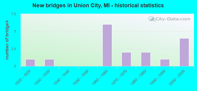
- New bridges - historical statistics
- 11920-1929
- 11930-1939
- 61960-1969
- 21970-1979
- 21980-1989
- 11990-1999
- 42000-2009

- Reconstructed bridges - Historical Statistics
- 11970-1979
- 01980-1989
- 01990-1999
- 12000-2009
- 12010-2019


- Bridge Condition - Deck
- 6.3%Excellent
- 37.5%Good
- 37.5%Satisfactory
- 12.5%Fair
- 6.3%Poor

- Bridge Condition - Superstructure
- 6.3%Excellent
- 6.3%Very good
- 25.0%Good
- 31.3%Satisfactory
- 25.0%Fair
- 6.3%Critical

- Bridge Condition - Substructure
- 6.3%Very good
- 37.5%Good
- 37.5%Satisfactory
- 6.3%Fair
- 6.3%Poor
- 6.3%Serious

- Bridge Condition - Channel
- 15.4%Very good
- 23.1%Good
- 23.1%Satisfactory
- 23.1%Fair
- 15.4%Poor
Find on map >> Show street view
Structure Number: 675, Location: 600 FT E OF NINE MILE RD (Lat: 43.639489, Lng: -84.066114), Route carried "on" structure: County highway 932, Year Built: 1993, Status: Open, Structure Length: 2.43m (7.97ft), Average Daily Traffic: 2,850 (year 2000), Truck Traffic: 10%, Average Future Daily Traffic: 4,560 (year 2020), Design Load: HS 20, Features Intersected: KAWKAWLIN RIVER, Facility Carried by Structure: WHEELER ROAD
Minimum Vertical Clearance: 30.48m (100.00ft), Kilometerpoint: 8.152, Lanes on structure: 2, Owner: County Highway Agency, Approaching Roadway Width: 9.1m (29.9ft), Skew: 4 degrees, Material/Design: Prestressed concrete, Design/Construction: Box Beam or Girders - Multiple, Number Of Spans In Main Unit: 1, Length of Maximum Span: 23.1m (75.8ft), Curb-To-Curb Width: 12.5m (41.0ft), Out-to-Out Width: 13.2m (43.3ft)
Condition: Deck: Satisfactory, Superstructure: Satisfactory, Substructure: Good, Channel: Good, Operating Rating: 70.6 metric tons, Method Used To Determine Operating Rating: Load and Resistance Factor Rating (LRFR) rating reported by rating factor(RF) method using HL-93 loadings, Inventory Rating: 54.4 metric tons, Method Used To Determine Inventory Rating: Load and Resistance Factor Rating (LRFR) rating reported by rating factor(RF) method using HL-93 loadings, Structural Evaluation: Equal to present minimum criteria, Deck Geometry: Equal to present minimum criteria, Waterway Adequacy: Equal to present desirable criteria, Approach Roadway Alignment: Equal to present desirable criteria, Designated Inspection Frequency: Every 24 months, Inspection Date: May 2020, Deck Structure Type: Concrete Precast Panels, Wearing Surface/Protective System: Wearing Surface: Bituminous, Deck Protection: Epoxy Coated Reinforcing
Find on map >> Show street view
Structure Number: 118, Location: 2 MI SE OF UNION CITY (Lat: 42.058342, Lng: -85.095433), Route carried "on" structure: County highway , Year Built: 2002, Status: Open, Structure Length: 0.86m (2.82ft), Average Daily Traffic: 74 (year 2004), Truck Traffic: 4%, Average Future Daily Traffic: 106 (year 2024), Design Load: HS 20, Features Intersected: UNION & TEKONSHA DRAIN, Facility Carried by Structure: HAYNER ROAD
Minimum Vertical Clearance: 30.48m (100.00ft), Kilometerpoint: 1.585, Lanes on structure: 2, Owner: County Highway Agency, Approaching Roadway Width: 6.1m (20.0ft), Skew: 2 degrees, Material/Design: Aluminum, Iron, Design/Construction: Culvert, Number Of Spans In Main Unit: 1, Length of Maximum Span: 8.6m (28.2ft), Curb-To-Curb Width: 9.1m (29.9ft), Out-to-Out Width: 17.3m (56.8ft)
Condition: Channel: Satisfactory, Culverts: Very good, Operating Rating: 68.7 metric tons, Method Used To Determine Operating Rating: Load Factor (LF) rating reported by rating factor (RF) method using MS18 loading, Inventory Rating: 50.5 metric tons, Method Used To Determine Inventory Rating: Load Factor (LF) rating reported by rating factor (RF) method using MS18 loading, Structural Evaluation: Equal to present desirable criteria, Waterway Adequacy: Equal to present minimum criteria, Approach Roadway Alignment: Equal to present desirable criteria, Designated Inspection Frequency: Every 24 months, Inspection Date: October 2020, Wearing Surface/Protective System: Wearing Surface: Bituminous
Find on map >> Show street view
Structure Number: 1189, Location: IN VILLAGE OF UNION CITY (Lat: 42.065767, Lng: -85.134131), Route carried "on" structure: Business City street 23, Year Built: 1978, Year Reconstructed: 2017, Status: Open, Structure Length: 4.15m (13.62ft), Average Daily Traffic: 3,315 (year 2016), Truck Traffic: 1%, Average Future Daily Traffic: 3,900 (year 2036), Design Load: HS 20, Features Intersected: ST JOSEPH RIVER, Facility Carried by Structure: BROADWAY STREET
Minimum Vertical Clearance: 30.48m (100.00ft), Kilometerpoint: 7.460, Lanes on structure: 2, Owner: City or Municipal Highway Agency, Approaching Roadway Width: 10.2m (33.5ft), Material/Design: Prestressed concrete, Design/Construction: Box Beam or Girders - Single/Spread, Number Of Spans In Main Unit: 2, Length of Maximum Span: 20.1m (65.9ft), Curb or Sidewalk Widths: Left: 1.8m (5.9ft), Right: 1.8m (5.9ft), Curb-To-Curb Width: 9.1m (29.9ft), Out-to-Out Width: 13.5m (44.3ft)
Condition: Deck: Excellent, Superstructure: Excellent, Substructure: Good, Channel: Good, Operating Rating: 69.7 metric tons, Method Used To Determine Operating Rating: Load and Resistance Factor Rating (LRFR) rating reported by rating factor(RF) method using HL-93 loadings, Inventory Rating: 41.8 metric tons, Method Used To Determine Inventory Rating: Load and Resistance Factor Rating (LRFR) rating reported by rating factor(RF) method using HL-93 loadings, Structural Evaluation: Better than present minimum criteria, Deck Geometry: Meets minimum limits, Waterway Adequacy: Equal to present desirable criteria, Approach Roadway Alignment: Equal to present desirable criteria, Length Of Structure Improvement: 4.14m (13.58ft), Designated Inspection Frequency: Every 24 months, Inspection Date: August 2021, Bridge Improvement Cost: $600,000,000, Roadway Improvement Cost: $50,000,000, Total Project Cost: $650,000,000, Deck Structure Type: Concrete Cast-file-Place, Wearing Surface/Protective System: Wearing Surface: Monolithic Concrete, Deck Protection: Epoxy Coated Reinforcing
Find on map >> Show street view
Structure Number: 1313, Location: BURLINGTON TWP SEC 19 (Lat: 42.115842, Lng: -85.177308), Route carried "on" structure: County highway , Year Built: 1988, Status: Posted for load, Structure Length: 0.85m (2.79ft), Average Daily Traffic: 657 (year 1995), Truck Traffic: 12%, Average Future Daily Traffic: 1,176 (year 2023), Design Load: HS 20, Features Intersected: NOTTAWA CREEK, Facility Carried by Structure: 6 MI ROAD
Minimum Vertical Clearance: 30.48m (100.00ft), Kilometerpoint: 5.317, Lanes on structure: 2, Owner: County Highway Agency, Approaching Roadway Width: 9.4m (30.8ft), Skew: 2 degrees, Material/Design: Wood or Timber, Design/Construction: Slab, Number Of Spans In Main Unit: 1, Length of Maximum Span: 8.5m (27.9ft), Curb-To-Curb Width: 9.4m (30.8ft), Out-to-Out Width: 9.7m (31.8ft)
Condition: Deck: Satisfactory, Superstructure: Satisfactory, Substructure: Satisfactory, Channel: Poor, Operating Rating: 33.5 metric tons, Method Used To Determine Operating Rating: Allowable Stress (AS), Inventory Rating: 22.8 metric tons, Method Used To Determine Inventory Rating: Allowable Stress (AS), Structural Evaluation: Equal to present minimum criteria, Deck Geometry: Equal to present minimum criteria, Waterway Adequacy: Equal to present desirable criteria, Approach Roadway Alignment: Equal to present desirable criteria, Bridge Posting: Required (Relationship of Operating Rating to Maximum Legal Load: > 39.9% below), Designated Inspection Frequency: Every 24 months, Inspection Date: September 2021, Deck Structure Type: Wood or Timber, Wearing Surface/Protective System: Wearing Surface: Bituminous
Find on map >> Show street view
Structure Number: 1315, Location: BURLINGTON TWP SEC 17 (Lat: 42.126328, Lng: -85.157014), Route carried "on" structure: County highway 1323, Year Built: 1962, Status: Open, Structure Length: 1.31m (4.30ft), Average Daily Traffic: 2,949 (year 1995), Truck Traffic: 14%, Average Future Daily Traffic: 5,277 (year 2023), Design Load: H 20, Features Intersected: NOTTAWA CREEK, Facility Carried by Structure: 7 MI ROAD
Minimum Vertical Clearance: 30.48m (100.00ft), Kilometerpoint: 6.584, Lanes on structure: 2, Owner: County Highway Agency, Approaching Roadway Width: 9.1m (29.9ft), Skew: 4 degrees, Material/Design: Prestressed concrete, Design/Construction: Box Beam or Girders - Multiple, Number Of Spans In Main Unit: 1, Length of Maximum Span: 13.1m (43.0ft), Curb or Sidewalk Widths: Left: 0.6m (2.0ft), Right: 0.6m (2.0ft), Curb-To-Curb Width: 8.2m (26.9ft), Out-to-Out Width: 9.8m (32.2ft)
Condition: Deck: Good, Superstructure: Good, Substructure: Good, Channel: Fair, Operating Rating: 53.7 metric tons, Method Used To Determine Operating Rating: Load Factor (LF), Inventory Rating: 25.2 metric tons, Method Used To Determine Inventory Rating: Load Factor (LF), Structural Evaluation: Equal to present minimum criteria, Deck Geometry: High priority of corrective action, Waterway Adequacy: Equal to present desirable criteria, Approach Roadway Alignment: Equal to present minimum criteria, Designated Inspection Frequency: Every 24 months, Inspection Date: September 2021, Deck Structure Type: Concrete Precast Panels, Wearing Surface/Protective System: Wearing Surface: Bituminous
Find on map >> Show street view
Structure Number: 1349, Location: 4 MI NE OF ATHENS (Lat: 42.123569, Lng: -85.163025), Route carried "on" structure: County highway , Year Built: 1920, Status: Posted for load, Structure Length: 0.82m (2.69ft), Average Daily Traffic: 159 (year 1994), Truck Traffic: 5%, Average Future Daily Traffic: 297 (year 2024), Design Load: H 10, Features Intersected: NOTTAWA CREEK, Facility Carried by Structure: Q DRIVE SOUTH
Minimum Vertical Clearance: 30.48m (100.00ft), Kilometerpoint: 1.394, Lanes on structure: 2, Owner: County Highway Agency, Approaching Roadway Width: 6.1m (20.0ft), Material/Design: Steel, Design/Construction: Stringer/Multi-beam, Number Of Spans In Main Unit: 1, Length of Maximum Span: 8.2m (26.9ft), Curb-To-Curb Width: 6.1m (20.0ft), Out-to-Out Width: 6.8m (22.3ft)
Condition: Deck: Satisfactory, Superstructure: Satisfactory, Substructure: Satisfactory, Channel: Fair, Operating Rating: 26.6 metric tons, Method Used To Determine Operating Rating: Load Factor (LF) rating reported by rating factor (RF) method using MS18 loading, Inventory Rating: 15.9 metric tons, Method Used To Determine Inventory Rating: Load Factor (LF) rating reported by rating factor (RF) method using MS18 loading, Structural Evaluation: Meets minimum limits, Deck Geometry: Meets minimum limits, Waterway Adequacy: Better than present minimum criteria, Approach Roadway Alignment: High priority of corrective action, Bridge Posting: Required (Relationship of Operating Rating to Maximum Legal Load: > 39.9% below), Length Of Structure Improvement: 1.40m (4.59ft), Designated Inspection Frequency: Every 12 months, Inspection Date: September 2021, Bridge Improvement Cost: $129,000, Roadway Improvement Cost: $95,000, Total Project Cost: $224,000, Deck Structure Type: Concrete Cast-file-Place, Wearing Surface/Protective System: Wearing Surface: Monolithic Concrete
Find on map >> Show street view
Structure Number: 1352, Location: 2 1/2 MI SW OF BURLINGTON (Lat: 42.081128, Lng: -85.119106), Route carried "on" structure: County highway , Year Built: 1968, Status: Posted for load, Structure Length: 3.17m (10.40ft), Average Daily Traffic: 580 (year 1994), Truck Traffic: 5%, Average Future Daily Traffic: 1,082 (year 2024), Design Load: HS 20+Mod, Features Intersected: ST JOSEPH RIVER, Facility Carried by Structure: 9 MILE ROAD
Minimum Vertical Clearance: 30.48m (100.00ft), Kilometerpoint: 0.946, Lanes on structure: 2, Owner: County Highway Agency, Approaching Roadway Width: 8.8m (28.9ft), Material/Design: Wood or Timber, Design/Construction: Slab, Number Of Spans In Main Unit: 4, Length of Maximum Span: 7.9m (25.9ft), Curb-To-Curb Width: 8.6m (28.2ft), Out-to-Out Width: 9.1m (29.9ft)
Condition: Deck: Fair, Superstructure: Fair, Substructure: Satisfactory, Channel: Fair, Operating Rating: 37.6 metric tons, Method Used To Determine Operating Rating: Allowable Stress (AS) rating reported by rating factor (RF) method using MS18 loading, Inventory Rating: 26.6 metric tons, Method Used To Determine Inventory Rating: Allowable Stress (AS) rating reported by rating factor (RF) method using MS18 loading, Structural Evaluation: Somewhat better than minimum adequacy, Deck Geometry: Somewhat better than minimum adequacy, Waterway Adequacy: Equal to present desirable criteria, Approach Roadway Alignment: Equal to present desirable criteria, Bridge Posting: Required (Relationship of Operating Rating to Maximum Legal Load: 30.0 - 39.9% below), Length Of Structure Improvement: 4.05m (13.29ft), Designated Inspection Frequency: Every 24 months, Inspection Date: September 2020, Deck Structure Type: Wood or Timber, Wearing Surface/Protective System: Wearing Surface: Bituminous, Deck Protection: Other
Find on map >> Show street view
Structure Number: 5902, Location: 2.8 MI E OF SCHLCRFT COL (Lat: 46.335503, Lng: -85.815831), Route carried "on" structure: State highway 28, Year Built: 1989, Status: Open, Structure Length: 1.52m (4.99ft), Average Daily Traffic: 1,763 (year 2007), Truck Traffic: 15%, Average Future Daily Traffic: 2,908 (year 2018), Design Load: HS 20, Features Intersected: E BR FOX RIVER
Minimum Vertical Clearance: 30.48m (100.00ft), Kilometerpoint: 3.771, Lanes on structure: 2, Base Highway Network: Yes (Inventory Route: 126, Subroute: 3), Owner: State Highway Agency, Approaching Roadway Width: 13.4m (44.0ft), Material/Design: Prestressed concrete, Design/Construction: Box Beam or Girders - Multiple, Number Of Spans In Main Unit: 1, Length of Maximum Span: 15.2m (49.9ft), Curb or Sidewalk Widths: Left: 2.3m (7.5ft), Right: 0.0m, Curb-To-Curb Width: 13.4m (44.0ft), Out-to-Out Width: 17.2m (56.4ft)
Condition: Deck: Good, Superstructure: Good, Substructure: Satisfactory, Channel: Satisfactory, Operating Rating: 72.3 metric tons, Method Used To Determine Operating Rating: Load Factor (LF) rating reported by rating factor (RF) method using MS18 loading, Inventory Rating: 43.1 metric tons, Method Used To Determine Inventory Rating: Load Factor (LF) rating reported by rating factor (RF) method using MS18 loading, Structural Evaluation: Equal to present minimum criteria, Deck Geometry: Equal to present desirable criteria, Waterway Adequacy: Better than present minimum criteria, Approach Roadway Alignment: Equal to present minimum criteria, Designated Inspection Frequency: Every 24 months, Inspection Date: June 2020, Deck Structure Type: Concrete Cast-file-Place, Wearing Surface/Protective System: Wearing Surface: Monolithic Concrete, Deck Protection: Epoxy Coated Reinforcing
Find on map >> Show street view
Structure Number: 6747, Location: BIG RAPIDS TWP SEC 13 (Lat: 43.691589, Lng: -85.456903), Route carried "on" structure: State highway 20, Year Built: 2000, Status: Open, Structure Length: 1.50m (4.92ft), Average Daily Traffic: 2,522 (year 2007), Truck Traffic: 10%, Average Future Daily Traffic: 3,533 (year 2018), Design Load: HS 25 or greater, Features Intersected: RYAN CREEK
Minimum Vertical Clearance: 30.48m (100.00ft), Kilometerpoint: 0.621, Lanes on structure: 2, Base Highway Network: Yes (Inventory Route: 52, Subroute: 7), Owner: State Highway Agency, Approaching Roadway Width: 9.8m (32.2ft), Material/Design: Prestressed concrete, Design/Construction: Box Beam or Girders - Multiple, Number Of Spans In Main Unit: 1, Length of Maximum Span: 13.8m (45.3ft), Curb-To-Curb Width: 13.4m (44.0ft), Out-to-Out Width: 14.3m (46.9ft)
Condition: Deck: Good, Superstructure: Very good, Substructure: Very good, Channel: Very good, Operating Rating: 91.1 metric tons, Method Used To Determine Operating Rating: Load Factor (LF), Inventory Rating: 48.3 metric tons, Method Used To Determine Inventory Rating: Load Factor (LF), Structural Evaluation: Equal to present desirable criteria, Deck Geometry: Better than present minimum criteria, Waterway Adequacy: Equal to present desirable criteria, Approach Roadway Alignment: Better than present minimum criteria, Designated Inspection Frequency: Every 24 months, Inspection Date: June 2021, Deck Structure Type: Concrete Cast-file-Place, Wearing Surface/Protective System: Wearing Surface: Monolithic Concrete, Deck Protection: Epoxy Coated Reinforcing
Find on map >> Show street view
Structure Number: 8676, Location: 2.7 MI S OF M-32 (Lat: 44.987883, Lng: -84.677158), Route carried "on" structure: County highway 6931, Year Built: 1961, Year Reconstructed: 1976, Status: Open, Structure Length: 8.11m (26.61ft), Average Daily Traffic: 13,645 (year 2007), Truck Traffic: 2%, Average Future Daily Traffic: 22,208 (year 2018), Design Load: H 15, Features Intersected: I-75, Facility Carried by Structure: OLD US-27,ALBA RD
Minimum Vertical Clearance: 30.48m (100.00ft), Kilometerpoint: 14.905, Lanes on structure: 5, Lanes under structure: 6, Owner: State Highway Agency, Approaching Roadway Width: 22.8m (74.8ft), Skew: 2 degrees, Material/Design: Steel, Design/Construction: Stringer/Multi-beam, Number Of Spans In Main Unit: 4, Length of Maximum Span: 28.0m (91.9ft), Curb-To-Curb Width: 21.8m (71.5ft), Out-to-Out Width: 22.3m (73.2ft)
Condition: Deck: Satisfactory, Superstructure: Fair, Substructure: Fair, Operating Rating: 63.5 metric tons, Method Used To Determine Operating Rating: Load Factor (LF) rating reported by rating factor (RF) method using MS18 loading, Inventory Rating: 24.3 metric tons, Method Used To Determine Inventory Rating: Load Factor (LF) rating reported by rating factor (RF) method using MS18 loading, Structural Evaluation: Somewhat better than minimum adequacy, Deck Geometry: Somewhat better than minimum adequacy, Underclear: High priority of corrective action, Approach Roadway Alignment: Equal to present minimum criteria, Designated Inspection Frequency: Every 24 months, Inspection Date: October 2020, Deck Structure Type: Concrete Cast-file-Place, Wearing Surface/Protective System: Wearing Surface: Epoxy Overlay
Find on map >> Show street view
Structure Number: 8679, Location: 3.0 MI N OF M-32 (Lat: 45.070822, Lng: -84.688947), Route carried "on" structure: County highway 6920, Year Built: 1961, Status: Open, Structure Length: 8.90m (29.20ft), Average Daily Traffic: 200 (year 1988), Truck Traffic: 2%, Average Future Daily Traffic: 150 (year 1977), Design Load: H 15, Features Intersected: I-75, Facility Carried by Structure: PARMATER RD
Minimum Vertical Clearance: 30.48m (100.00ft), Kilometerpoint: 13.144, Lanes on structure: 2, Lanes under structure: 4, Owner: State Highway Agency, Approaching Roadway Width: 10.9m (35.8ft), Material/Design: Steel, Design/Construction: Stringer/Multi-beam, Number Of Spans In Main Unit: 6, Length of Maximum Span: 17.9m (58.7ft), Curb-To-Curb Width: 7.3m (24.0ft), Out-to-Out Width: 9.4m (30.8ft)
Condition: Deck: Good, Superstructure: Fair, Substructure: Satisfactory, Operating Rating: 55.1 metric tons, Method Used To Determine Operating Rating: Load Factor (LF) rating reported by rating factor (RF) method using MS18 loading, Inventory Rating: 29.5 metric tons, Method Used To Determine Inventory Rating: Load Factor (LF) rating reported by rating factor (RF) method using MS18 loading, Structural Evaluation: Somewhat better than minimum adequacy, Deck Geometry: Somewhat better than minimum adequacy, Underclear: Meets minimum limits, Approach Roadway Alignment: Equal to present minimum criteria, Length Of Structure Improvement: 8.90m (29.20ft), Designated Inspection Frequency: Every 24 months, Inspection Date: September 2020, Bridge Improvement Cost: $106,000, Roadway Improvement Cost: $6,000, Total Project Cost: $66,000, Deck Structure Type: Concrete Cast-file-Place, Wearing Surface/Protective System: Wearing Surface: Monolithic Concrete
Find on map >> Show street view
Structure Number: 8818, Location: 0.1 MI SE OF CHICAGO DRIV (Lat: 42.903336, Lng: -85.784694), Route carried "on" structure: County highway 2001, Year Built: 1965, Status: Open, Structure Length: 1.40m (4.59ft), Average Daily Traffic: 6,200 (year 2020), Truck Traffic: 5%, Average Future Daily Traffic: 11,190 (year 2040), Design Load: H 20, Features Intersected: RUSH CREEK, Facility Carried by Structure: MAIN STREET
Minimum Vertical Clearance: 30.48m (100.00ft), Kilometerpoint: 0.261, Lanes on structure: 2, Owner: County Highway Agency, Approaching Roadway Width: 11.0m (36.1ft), Material/Design: Steel, Design/Construction: Stringer/Multi-beam, Number Of Spans In Main Unit: 1, Length of Maximum Span: 13.4m (44.0ft), Curb or Sidewalk Widths: Left: 1.1m (3.6ft), Right: 1.1m (3.6ft), Curb-To-Curb Width: 8.5m (27.9ft), Out-to-Out Width: 10.6m (34.8ft)
Condition: Deck: Good, Superstructure: Good, Substructure: Good, Channel: Very good, Operating Rating: 61.9 metric tons, Method Used To Determine Operating Rating: Load Factor (LF) rating reported by rating factor (RF) method using MS18 loading, Inventory Rating: 36.9 metric tons, Method Used To Determine Inventory Rating: Load Factor (LF) rating reported by rating factor (RF) method using MS18 loading, Structural Evaluation: Better than present minimum criteria, Deck Geometry: High priority of replacement, Waterway Adequacy: Better than present minimum criteria, Approach Roadway Alignment: Better than present minimum criteria, Designated Inspection Frequency: Every 24 months, Inspection Date: December 2020, Deck Structure Type: Concrete Cast-file-Place, Wearing Surface/Protective System: Wearing Surface: Monolithic Concrete
Find on map >> Show street view
Structure Number: 9259, Location: 0.6 MI N OF YOUNG ROAD (Lat: 43.360894, Lng: -83.934883), Route carried "on" structure: County highway 7365, Year Built: 2002, Status: Open, Structure Length: 6.09m (19.98ft), Average Daily Traffic: 1,931 (year 2018), Truck Traffic: 5%, Average Future Daily Traffic: 2,028 (year 2028), Design Load: HS 20, Features Intersected: CASS RIVER OVERFLOW, Facility Carried by Structure: SHERIDAN ROAD
Minimum Vertical Clearance: 30.48m (100.00ft), Kilometerpoint: 25.400, Lanes on structure: 2, Owner: County Highway Agency, Approaching Roadway Width: 9.1m (29.9ft), Skew: 2 degrees, Material/Design: Prestressed concrete, Design/Construction: Box Beam or Girders - Single/Spread, Number Of Spans In Main Unit: 3, Length of Maximum Span: 23.2m (76.1ft), Curb-To-Curb Width: 9.1m (29.9ft), Out-to-Out Width: 9.9m (32.5ft)
Condition: Deck: Good, Superstructure: Satisfactory, Substructure: Satisfactory, Channel: Good, Operating Rating: 67.1 metric tons, Method Used To Determine Operating Rating: Load and Resistance Factor Rating (LRFR) rating reported by rating factor(RF) method using HL-93 loadings, Inventory Rating: 44.4 metric tons, Method Used To Determine Inventory Rating: Load and Resistance Factor Rating (LRFR) rating reported by rating factor(RF) method using HL-93 loadings, Structural Evaluation: Equal to present minimum criteria, Deck Geometry: Somewhat better than minimum adequacy, Waterway Adequacy: Equal to present minimum criteria, Approach Roadway Alignment: Equal to present desirable criteria, Designated Inspection Frequency: Every 24 months, Inspection Date: May 2021, Deck Structure Type: Concrete Cast-file-Place, Wearing Surface/Protective System: Wearing Surface: Monolithic Concrete, Deck Protection: Epoxy Coated Reinforcing
Find on map >> Show street view
Structure Number: 10007, Location: @ I94BL (GRATIOT)- (Lat: 42.907489, Lng: -82.505103), Route carried "on" structure: Interstate 94, Year Built: 2006, Status: Open, Structure Length: 5.36m (17.59ft), Average Daily Traffic: 7,908 (year 2007), Truck Traffic: 2%, Average Future Daily Traffic: 20,330 (year 2026), Design Load: HS 25 or greater, Features Intersected: I-94 BL (GRATIOT)
Minimum Vertical Clearance: 30.48m (100.00ft), Kilometerpoint: 22.567, Lanes on structure: 3, Lanes under structure: 6, Base Highway Network: Yes (Inventory Route: 96, Subroute: 9), Owner: State Highway Agency, Approaching Roadway Width: 14.0m (45.9ft), Skew: 12 degrees, Material/Design: Prestressed concrete, Design/Construction: Stringer/Multi-beam, Number Of Spans In Main Unit: 2, Length of Maximum Span: 28.3m (92.8ft), Curb-To-Curb Width: 18.9m (62.0ft), Out-to-Out Width: 19.9m (65.3ft)
Condition: Deck: Satisfactory, Superstructure: Good, Substructure: Good, Operating Rating: 90.4 metric tons, Method Used To Determine Operating Rating: Load Factor (LF) rating reported by rating factor (RF) method using MS18 loading, Inventory Rating: 44.4 metric tons, Method Used To Determine Inventory Rating: Load Factor (LF) rating reported by rating factor (RF) method using MS18 loading, Structural Evaluation: Better than present minimum criteria, Deck Geometry: Superior to present desirable criteria, Underclear: Better than present minimum criteria, Approach Roadway Alignment: Better than present minimum criteria, Designated Inspection Frequency: Every 24 months, Inspection Date: August 2020, Deck Structure Type: Concrete Cast-file-Place, Wearing Surface/Protective System: Wearing Surface: Epoxy Overlay, Deck Protection: Epoxy Coated Reinforcing
Find on map >> Show street view
Structure Number: 10362, Location: 5 MI SE OF CENTREVILLE (Lat: 41.897561, Lng: -85.454708), Route carried "on" structure: County highway , Year Built: 1972, Status: Open, Structure Length: 3.04m (9.97ft), Average Daily Traffic: 333 (year 2003), Truck Traffic: 5%, Average Future Daily Traffic: 489 (year 2023), Design Load: H 20, Features Intersected: PRAIRIE RIVER, Facility Carried by Structure: FINDLEY ROAD
Minimum Vertical Clearance: 30.48m (100.00ft), Kilometerpoint: 2.779, Lanes on structure: 2, Owner: County Highway Agency, Approaching Roadway Width: 9.1m (29.9ft), Material/Design: Wood or Timber, Design/Construction: Slab, Number Of Spans In Main Unit: 5, Length of Maximum Span: 6.1m (20.0ft), Curb-To-Curb Width: 9.1m (29.9ft), Out-to-Out Width: 9.7m (31.8ft)
Condition: Deck: Fair, Superstructure: Fair, Substructure: Poor, Channel: Satisfactory, Operating Rating: 50.9 metric tons, Method Used To Determine Operating Rating: Allowable Stress (AS) rating reported by rating factor (RF) method using MS18 loading, Inventory Rating: 36.3 metric tons, Method Used To Determine Inventory Rating: Allowable Stress (AS) rating reported by rating factor (RF) method using MS18 loading, Structural Evaluation: Meets minimum limits, Deck Geometry: Equal to present minimum criteria, Waterway Adequacy: Equal to present desirable criteria, Approach Roadway Alignment: Somewhat better than minimum adequacy, Designated Inspection Frequency: Every 24 months, Inspection Date: November 2021, Deck Structure Type: Wood or Timber, Wearing Surface/Protective System: Wearing Surface: Bituminous
Find on map >> Show street view
Structure Number: 10687, Location: 5.1 MI NE OF BERRIEN COL (Lat: 42.301753, Lng: -86.309053), Route carried "on" structure: Interstate 196, Year Built: 1963, Year Reconstructed: 2014, Status: Open, Structure Length: 3.35m (10.99ft), Average Daily Traffic: 17,400 (year 2014), Truck Traffic: 26%, Average Future Daily Traffic: 20,200 (year 2034), Design Load: HS 20+Mod, Features Intersected: 32 ND AVE (CR378)
Minimum Vertical Clearance: 30.48m (100.00ft), Kilometerpoint: 7.538, Lanes on structure: 2, Lanes under structure: 2, Base Highway Network: Yes (Inventory Route: 58, Subroute: 2), Owner: State Highway Agency, Approaching Roadway Width: 12.0m (39.4ft), Skew: 1 degrees, Material/Design: Prestressed concrete, Design/Construction: Stringer/Multi-beam, Number Of Spans In Main Unit: 3, Length of Maximum Span: 12.7m (41.7ft), Curb-To-Curb Width: 12.0m (39.4ft), Out-to-Out Width: 13.0m (42.7ft)
Condition: Deck: Satisfactory, Superstructure: Satisfactory, Substructure: Good, Operating Rating: 53.1 metric tons, Method Used To Determine Operating Rating: Load Factor (LF) rating reported by rating factor (RF) method using MS18 loading, Inventory Rating: 31.8 metric tons, Method Used To Determine Inventory Rating: Load Factor (LF) rating reported by rating factor (RF) method using MS18 loading, Structural Evaluation: Equal to present minimum criteria, Deck Geometry: Equal to present minimum criteria, Underclear: Meets minimum limits, Approach Roadway Alignment: Equal to present desirable criteria, Length Of Structure Improvement: 3.35m (10.99ft), Designated Inspection Frequency: Every 24 months, Inspection Date: October 2021, Bridge Improvement Cost: $18,000, Roadway Improvement Cost: $2,000, Total Project Cost: $21,000, Deck Structure Type: Concrete Cast-file-Place, Wearing Surface/Protective System: Wearing Surface: Latex Concrete
Find on map >> Show street view
Structure Number: 12819, Location: UNION TWP SEC 15-16 (Lat: 42.038108, Lng: -85.119192), Route carried "on" structure: County highway , Year Built: 1930, Status: Posted for load, Structure Length: 0.80m (2.62ft), Average Daily Traffic: 53 (year 2004), Truck Traffic: 5%, Average Future Daily Traffic: 92 (year 2024), Design Load: H 15, Features Intersected: UNION DRAIN #2, Facility Carried by Structure: CLAY ROAD
Minimum Vertical Clearance: 30.48m (100.00ft), Kilometerpoint: 1.082, Lanes on structure: 2, Owner: County Highway Agency, Approaching Roadway Width: 6.1m (20.0ft), Material/Design: Steel, Design/Construction: Stringer/Multi-beam, Number Of Spans In Main Unit: 1, Length of Maximum Span: 6.7m (22.0ft), Curb-To-Curb Width: 4.3m (14.1ft), Out-to-Out Width: 4.3m (14.1ft)
Condition: Deck: Poor, Superstructure: Critical, Substructure: Serious, Channel: Poor, Operating Rating: 18.1 metric tons, Method Used To Determine Operating Rating: Load Factor (LF) rating reported by rating factor (RF) method using MS18 loading, Inventory Rating: 13.9 metric tons, Method Used To Determine Inventory Rating: Load Factor (LF) rating reported by rating factor (RF) method using MS18 loading, Structural Evaluation: High priority of replacement, Deck Geometry: High priority of replacement, Waterway Adequacy: Meets minimum limits, Approach Roadway Alignment: High priority of corrective action, Bridge Posting: Required (Relationship of Operating Rating to Maximum Legal Load: > 39.9% below), Length Of Structure Improvement: 1.00m (3.28ft), Designated Inspection Frequency: Every 12 months, Inspection Date: October 2021, Bridge Improvement Cost: $156,000, Roadway Improvement Cost: $15,000, Total Project Cost: $190,000, Deck Structure Type: Concrete Cast-file-Place, Wearing Surface/Protective System: Wearing Surface: Monolithic Concrete