Bridge Statistics for Union Bridge, Maryland (MD)
Condition, Traffic, Stress, Structural Evaluation, Project Costs
- National Bridge Inventory (NBI) Statistics
- 21Number of bridges
- 138ft / 42.0mTotal length
- $660,000Total costs
- 20,206Total average daily traffic
- 1,791Total average daily truck traffic
- 28,017Total future (year 2026) average daily traffic
- National Bridge Inventory (NBI) Registered Bridges for Union Bridge
- No street view available for this location
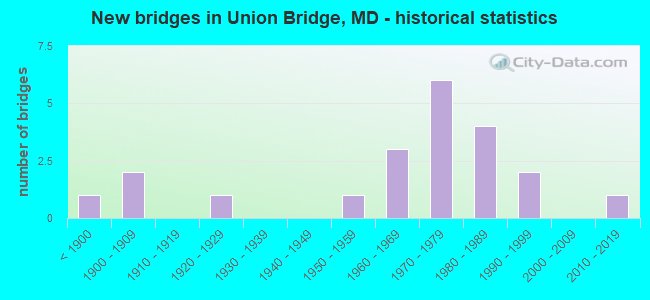
- New bridges - historical statistics
- 1Before 1900
- 21900-1909
- 11920-1929
- 11950-1959
- 31960-1969
- 61970-1979
- 41980-1989
- 21990-1999
- 12010-2019

- Reconstructed bridges - Historical Statistics
- 11930-1939
- 01940-1949
- 01950-1959
- 11960-1969
- 01970-1979
- 01980-1989
- 21990-1999
- 12000-2009
- 12010-2019


- Bridge Condition - Deck
- 7.7%Very good
- 30.8%Good
- 46.2%Satisfactory
- 15.4%Fair

- Bridge Condition - Superstructure
- 38.5%Good
- 30.8%Satisfactory
- 7.7%Fair
- 23.1%Poor

- Bridge Condition - Substructure
- 7.7%Very good
- 30.8%Good
- 38.5%Satisfactory
- 15.4%Fair
- 7.7%Poor

- Bridge Condition - Channel
- 9.5%Very good
- 19.0%Good
- 66.7%Satisfactory
- 4.8%Fair

- Bridge Condition - Culverts
- 37.5%Very good
- 50.0%Good
- 12.5%Satisfactory
Find on map >> Show street view
Structure Number: 10000006001201, Location: ON FREDERICK CO LINE (Lat: 39.559639, Lng: -77.181528), Route carried "on" structure: State highway 75, Year Built: 1972, Status: Open, Structure Length: 2.56m (8.40ft), Average Daily Traffic: 2,151 (year 2009), Truck Traffic: 8%, Average Future Daily Traffic: 2,261 (year 2026), Design Load: HS 20, Features Intersected: SAMS CREEK
Minimum Vertical Clearance: 30+ m (98+ ft), Kilometerpoint: 0.000, Lanes on structure: 2, Owner: State Highway Agency, Approaching Roadway Width: 13.4m (44.0ft), Skew: 3 degrees, Material/Design: Prestressed concrete, Design/Construction: Slab, Number Of Spans In Main Unit: 2, Length of Maximum Span: 12.2m (40.0ft), Curb-To-Curb Width: 13.9m (45.6ft), Out-to-Out Width: 14.8m (48.6ft)
Condition: Deck: Satisfactory, Superstructure: Satisfactory, Substructure: Good, Channel: Satisfactory, Operating Rating: 75.7 metric tons, Method Used To Determine Operating Rating: Load Factor (LF), Inventory Rating: 45.4 metric tons, Method Used To Determine Inventory Rating: Load Factor (LF), Structural Evaluation: Equal to present minimum criteria, Deck Geometry: Superior to present desirable criteria, Waterway Adequacy: Better than present minimum criteria, Approach Roadway Alignment: Equal to present minimum criteria, Designated Inspection Frequency: Every 24 months, Underwater Inspection Frequency: Every 48 months, Inspection Date: April 2021, Underwater Inspection Date: August 2021, Deck Structure Type: Concrete Cast-file-Place, Wearing Surface/Protective System: Wearing Surface: Integral Concrete
Find on map >> Show street view
Structure Number: 10000006001301, Location: 0.18 MI S OF UNION BRIDGE (Lat: 39.572528, Lng: -77.176167), Route carried "on" structure: State highway 75, Year Built: 1922, Year Reconstructed: 1939, Status: Open, Structure Length: 1.22m (4.00ft), Average Daily Traffic: 4,051 (year 2009), Truck Traffic: 8%, Average Future Daily Traffic: 4,994 (year 2026), Features Intersected: LITTLE PIPE CREEK
Minimum Vertical Clearance: 30+ m (98+ ft), Kilometerpoint: 1.464, Lanes on structure: 2, Owner: State Highway Agency, Approaching Roadway Width: 7.9m (25.9ft), Material/Design: Concrete, Design/Construction: Tee Beam, Number Of Spans In Main Unit: 1, Length of Maximum Span: 11.0m (36.1ft), Curb or Sidewalk Widths: Left: 2.1m (6.9ft), Right: 0.0m, Curb-To-Curb Width: 7.3m (24.0ft), Out-to-Out Width: 10.3m (33.8ft)
Condition: Deck: Fair, Superstructure: Fair, Substructure: Fair, Channel: Satisfactory, Operating Rating: 64.9 metric tons, Method Used To Determine Operating Rating: Load Factor (LF), Inventory Rating: 39.0 metric tons, Method Used To Determine Inventory Rating: Load Factor (LF), Structural Evaluation: Somewhat better than minimum adequacy, Deck Geometry: High priority of replacement, Waterway Adequacy: Better than present minimum criteria, Approach Roadway Alignment: Equal to present desirable criteria, Length Of Structure Improvement: 1.22m (4.00ft), Designated Inspection Frequency: Every 24 months, Underwater Inspection Frequency: Every 48 months, Inspection Date: May 2020, Underwater Inspection Date: August 2021, Bridge Improvement Cost: $81,000, Roadway Improvement Cost: $8,000, Total Project Cost: $89,000, Deck Structure Type: Concrete Cast-file-Place, Wearing Surface/Protective System: Wearing Surface: Bituminous
Find on map >> Show street view
Structure Number: 10000006006503, Location: 0.05 MI N OF FREDERICK CO (Lat: 39.560631, Lng: -77.181242), Route carried "on" structure: State highway 75, Year Built: 1982, Status: Open, Structure Length: 0.64m (2.10ft), Average Daily Traffic: 2,172 (year 2010), Truck Traffic: 8%, Average Future Daily Traffic: 2,261 (year 2026), Features Intersected: ABANDON MILL RUN
Minimum Vertical Clearance: 30+ m (98+ ft), Kilometerpoint: 0.080, Lanes on structure: 2, Owner: State Highway Agency, Approaching Roadway Width: 11.0m (36.1ft), Material/Design: Steel, Design/Construction: Culvert, Length of Maximum Span: 1.5m (4.9ft)
Condition: Channel: Satisfactory, Culverts: Satisfactory, Structural Evaluation: Equal to present minimum criteria, Waterway Adequacy: Superior to present desirable criteria, Approach Roadway Alignment: Equal to present desirable criteria, Designated Inspection Frequency: Every 24 months, Inspection Date: April 2021
Find on map >> Show street view
Structure Number: 10000010007201, Location: ON CARROLL CO LINE (Lat: 39.591000, Lng: -77.242756), Route carried "on" structure: State highway 194, Year Built: 1953, Year Reconstructed: 2017, Status: Open, Structure Length: 4.15m (13.62ft), Average Daily Traffic: 4,425 (year 2013), Truck Traffic: 8%, Average Future Daily Traffic: 5,175 (year 2033), Features Intersected: LITTLE PIPE CREEK
Minimum Vertical Clearance: 30+ m (98+ ft), Kilometerpoint: 19.968, Lanes on structure: 2, Base Highway Network: Yes, Owner: State Highway Agency, Approaching Roadway Width: 11.0m (36.1ft), Material/Design: Steel continuous, Design/Construction: Stringer/Multi-beam, Number Of Spans In Main Unit: 3, Length of Maximum Span: 15.2m (49.9ft), Curb or Sidewalk Widths: Left: 0.6m (2.0ft), Right: 0.6m (2.0ft), Curb-To-Curb Width: 11.0m (36.1ft), Out-to-Out Width: 12.2m (40.0ft)
Condition: Deck: Very good, Superstructure: Good, Substructure: Good, Channel: Satisfactory, Operating Rating: 62.9 metric tons, Method Used To Determine Operating Rating: Load and Resistance Factor Rating (LRFR) rating reported by rating factor(RF) method using HL-93 loadings, Inventory Rating: 48.3 metric tons, Method Used To Determine Inventory Rating: Load and Resistance Factor Rating (LRFR) rating reported by rating factor(RF) method using HL-93 loadings, Structural Evaluation: Better than present minimum criteria, Deck Geometry: Somewhat better than minimum adequacy, Waterway Adequacy: Better than present minimum criteria, Approach Roadway Alignment: Equal to present desirable criteria, Designated Inspection Frequency: Every 24 months, Inspection Date: July 2021, Deck Structure Type: Concrete Cast-file-Place, Wearing Surface/Protective System: Wearing Surface: Monolithic Concrete
Find on map >> Show street view
Structure Number: 10000010017201, Location: 0.56 MI S OF CARROLL CO (Lat: 39.552300, Lng: -77.182217), Route carried "on" structure: State highway 75, Year Built: 2015, Status: Open, Structure Length: 1.14m (3.74ft), Average Daily Traffic: 1,150 (year 2011), Truck Traffic: 8%, Average Future Daily Traffic: 2,100 (year 2031), Features Intersected: HAINES BRANCH
Minimum Vertical Clearance: 30+ m (98+ ft), Kilometerpoint: 36.273, Lanes on structure: 2, Owner: State Highway Agency, Approaching Roadway Width: 6.7m (22.0ft), Material/Design: Prestressed concrete, Design/Construction: Slab, Number Of Spans In Main Unit: 1, Length of Maximum Span: 10.1m (33.1ft), Curb-To-Curb Width: 10.9m (35.8ft), Out-to-Out Width: 12.2m (40.0ft)
Condition: Deck: Good, Superstructure: Good, Substructure: Very good, Channel: Very good, Operating Rating: 97.2 metric tons, Method Used To Determine Operating Rating: Load and Resistance Factor Rating (LRFR) rating reported by rating factor(RF) method using HL-93 loadings, Inventory Rating: 80.4 metric tons, Method Used To Determine Inventory Rating: Load and Resistance Factor Rating (LRFR) rating reported by rating factor(RF) method using HL-93 loadings, Structural Evaluation: Better than present minimum criteria, Deck Geometry: Equal to present minimum criteria, Waterway Adequacy: Better than present minimum criteria, Approach Roadway Alignment: Equal to present desirable criteria, Designated Inspection Frequency: Every 24 months, Inspection Date: November 2021, Deck Structure Type: Concrete Cast-file-Place, Wearing Surface/Protective System: Wearing Surface: Monolithic Concrete
Find on map >> Show street view
Structure Number: 200000CL023201, Location: .15 MI S OF SHARRETT ROAD (Lat: 39.608169, Lng: -77.210528), Route carried "on" structure: County highway 24, Year Built: 1976, Status: Open, Structure Length: 5.40m (17.72ft), Average Daily Traffic: 668 (year 2021), Truck Traffic: 5%, Average Future Daily Traffic: 1,100 (year 2041), Design Load: HS 20, Features Intersected: BIG PIPE CREEK, Facility Carried by Structure: CROUSE MILL ROAD
Minimum Vertical Clearance: 30+ m (98+ ft), Kilometerpoint: 5.792, Lanes on structure: 2, Owner: County Highway Agency, Approaching Roadway Width: 6.4m (21.0ft), Skew: 1 degrees, Material/Design: Steel, Design/Construction: Stringer/Multi-beam, Number Of Spans In Main Unit: 3, Length of Maximum Span: 27.4m (89.9ft), Curb-To-Curb Width: 9.8m (32.2ft), Out-to-Out Width: 10.7m (35.1ft)
Condition: Deck: Satisfactory, Superstructure: Good, Substructure: Satisfactory, Channel: Satisfactory, Operating Rating: 86.6 metric tons, Method Used To Determine Operating Rating: Load Factor (LF), Inventory Rating: 51.7 metric tons, Method Used To Determine Inventory Rating: Load Factor (LF), Structural Evaluation: Equal to present minimum criteria, Deck Geometry: Equal to present minimum criteria, Waterway Adequacy: Equal to present desirable criteria, Approach Roadway Alignment: Equal to present desirable criteria, Designated Inspection Frequency: Every 24 months, Inspection Date: September 2021, Deck Structure Type: Concrete Cast-file-Place, Wearing Surface/Protective System: Wearing Surface: Integral Concrete
Find on map >> Show street view
Structure Number: 200000CL023401, Location: 1 MI E CROUSE MILL RD (Lat: 39.613681, Lng: -77.187906), Route carried "on" structure: County highway 25, Year Built: 1974, Status: Open, Structure Length: 3.84m (12.60ft), Average Daily Traffic: 102 (year 2021), Truck Traffic: 5%, Average Future Daily Traffic: 170 (year 2041), Design Load: HS 20, Features Intersected: BIG PIPE CREEK, Facility Carried by Structure: HAPES MILL ROAD
Minimum Vertical Clearance: 30+ m (98+ ft), Kilometerpoint: 2.430, Lanes on structure: 2, Owner: County Highway Agency, Approaching Roadway Width: 6.7m (22.0ft), Material/Design: Steel continuous, Design/Construction: Stringer/Multi-beam, Number Of Spans In Main Unit: 2, Length of Maximum Span: 18.6m (61.0ft), Curb-To-Curb Width: 7.3m (24.0ft), Out-to-Out Width: 8.3m (27.2ft)
Condition: Deck: Satisfactory, Superstructure: Satisfactory, Substructure: Satisfactory, Channel: Fair, Operating Rating: 67.1 metric tons, Method Used To Determine Operating Rating: Load Factor (LF), Inventory Rating: 40.4 metric tons, Method Used To Determine Inventory Rating: Load Factor (LF), Structural Evaluation: Equal to present minimum criteria, Deck Geometry: Somewhat better than minimum adequacy, Waterway Adequacy: Equal to present minimum criteria, Approach Roadway Alignment: Equal to present desirable criteria, Designated Inspection Frequency: Every 24 months, Inspection Date: September 2021, Deck Structure Type: Concrete Cast-file-Place
Find on map >> Show street view
Structure Number: 200000CL023601, Location: 0.04 MI S OF MD 75 (Lat: 39.564506, Lng: -77.143525), Route carried "on" structure: County highway 235, Year Built: 1900, Year Reconstructed: 1972, Status: Open, Structure Length: 1.20m (3.94ft), Average Daily Traffic: 234 (year 2021), Truck Traffic: 10%, Average Future Daily Traffic: 383 (year 2041), Features Intersected: LITTLE PIPE CREEK, Facility Carried by Structure: MCKINSTRY MILL RD
Minimum Vertical Clearance: 30+ m (98+ ft), Kilometerpoint: 0.064, Lanes on structure: 2, Owner: County Highway Agency, Approaching Roadway Width: 6.1m (20.0ft), Skew: 1 degrees, Material/Design: Steel, Design/Construction: Stringer/Multi-beam, Number Of Spans In Main Unit: 1, Length of Maximum Span: 11.9m (39.0ft), Curb-To-Curb Width: 5.0m (16.4ft), Out-to-Out Width: 6.1m (20.0ft)
Condition: Deck: Satisfactory, Superstructure: Poor, Substructure: Satisfactory, Channel: Satisfactory, Operating Rating: 67.1 metric tons, Method Used To Determine Operating Rating: Load Factor (LF), Inventory Rating: 40.4 metric tons, Method Used To Determine Inventory Rating: Load Factor (LF), Structural Evaluation: Meets minimum limits, Waterway Adequacy: Better than present minimum criteria, Approach Roadway Alignment: Equal to present minimum criteria, Length Of Structure Improvement: 1.19m (3.90ft), Designated Inspection Frequency: Every 24 months, Inspection Date: September 2021, Bridge Improvement Cost: $60,000, Roadway Improvement Cost: $6,000, Total Project Cost: $66,000, Deck Structure Type: Concrete Cast-file-Place
Find on map >> Show street view
Structure Number: 200000CL023703, Location: UNION BRIDGE ROAD (Lat: 39.584364, Lng: -77.179003), Route carried "on" structure: County highway 218, Year Built: 1990, Status: Open, Structure Length: 0.88m (2.89ft), Average Daily Traffic: 1,034 (year 2021), Truck Traffic: 8%, Average Future Daily Traffic: 1,700 (year 2041), Features Intersected: CHERRY BRANCH, Facility Carried by Structure: UNION BRIDGE ROAD
Minimum Vertical Clearance: 30+ m (98+ ft), Kilometerpoint: 0.000, Lanes on structure: 2, Owner: County Highway Agency, Approaching Roadway Width: 6.1m (20.0ft), Skew: 4 degrees, Material/Design: Steel, Design/Construction: Culvert, Length of Maximum Span: 1.8m (5.9ft), Curb-To-Curb Width: 9.5m (31.2ft), Out-to-Out Width: 10.1m (33.1ft)
Condition: Channel: Satisfactory, Culverts: Good, Inventory Rating: 62.6 metric tons, Method Used To Determine Inventory Rating: Load Factor (LF), Structural Evaluation: Better than present minimum criteria, Deck Geometry: Somewhat better than minimum adequacy, Waterway Adequacy: Equal to present desirable criteria, Approach Roadway Alignment: Equal to present minimum criteria, Designated Inspection Frequency: Every 24 months, Inspection Date: September 2021
Find on map >> Show street view
Structure Number: 200000CL023801, Location: 0.02 MI W OF UNION BRIDGE (Lat: 39.568842, Lng: -77.184075), Route carried "on" structure: County highway 216, Year Built: 1960, Year Reconstructed: 2006, Status: Open, Structure Length: 1.25m (4.10ft), Average Daily Traffic: 1,159 (year 2021), Truck Traffic: 10%, Average Future Daily Traffic: 1,900 (year 2041), Features Intersected: LITTLE PIPE CREEK, Facility Carried by Structure: BUCHER JOHN ROAD
Minimum Vertical Clearance: 30+ m (98+ ft), Kilometerpoint: 0.032, Lanes on structure: 2, Owner: County Highway Agency, Approaching Roadway Width: 7.3m (24.0ft), Material/Design: Steel, Design/Construction: Stringer/Multi-beam, Number Of Spans In Main Unit: 1, Length of Maximum Span: 11.3m (37.1ft), Curb-To-Curb Width: 7.6m (24.9ft), Out-to-Out Width: 8.4m (27.6ft)
Condition: Deck: Good, Superstructure: Good, Substructure: Good, Channel: Satisfactory, Inventory Rating: 86.6 metric tons, Method Used To Determine Inventory Rating: Load Factor (LF), Structural Evaluation: Better than present minimum criteria, Deck Geometry: Meets minimum limits, Waterway Adequacy: Better than present minimum criteria, Approach Roadway Alignment: Equal to present minimum criteria, Designated Inspection Frequency: Every 24 months, Inspection Date: September 2021, Deck Structure Type: Concrete Cast-file-Place
Find on map >> Show street view
Structure Number: 200000CL023901, Location: ON FREDERICK CO LINE (Lat: 39.568544, Lng: -77.189689), Route carried "on" structure: County highway 215, Year Built: 1977, Status: Open, Structure Length: 5.61m (18.41ft), Average Daily Traffic: 748 (year 2021), Truck Traffic: 5%, Average Future Daily Traffic: 1,230 (year 2041), Design Load: HS 20, Features Intersected: LITTLE PIPE CREEK, Facility Carried by Structure: GOOD INTENT ROAD
Minimum Vertical Clearance: 30+ m (98+ ft), Kilometerpoint: 0.209, Lanes on structure: 2, Base Highway Network: Yes, Owner: County Highway Agency, Approaching Roadway Width: 6.7m (22.0ft), Skew: 2 degrees, Material/Design: Steel continuous, Design/Construction: Stringer/Multi-beam, Number Of Spans In Main Unit: 3, Length of Maximum Span: 22.6m (74.1ft), Curb-To-Curb Width: 9.8m (32.2ft), Out-to-Out Width: 10.7m (35.1ft)
Condition: Deck: Good, Superstructure: Good, Substructure: Good, Channel: Satisfactory, Operating Rating: 74.4 metric tons, Method Used To Determine Operating Rating: Load Factor (LF), Inventory Rating: 44.4 metric tons, Method Used To Determine Inventory Rating: Load Factor (LF), Structural Evaluation: Better than present minimum criteria, Deck Geometry: Equal to present minimum criteria, Waterway Adequacy: Equal to present desirable criteria, Approach Roadway Alignment: Equal to present desirable criteria, Designated Inspection Frequency: Every 24 months, Inspection Date: May 2021, Deck Structure Type: Concrete Cast-file-Place, Wearing Surface/Protective System: Wearing Surface: Monolithic Concrete
Find on map >> Show street view
Structure Number: 200000CL024101, Location: WEST OF NEW WINDSOR (Lat: 39.533039, Lng: -77.158814), Route carried "on" structure: County highway 234, Year Built: 1908, Year Reconstructed: 1997, Status: Posted for load, Structure Length: 2.06m (6.76ft), Average Daily Traffic: 23 (year 2021), Truck Traffic: 2%, Average Future Daily Traffic: 40 (year 2041), Features Intersected: SAMS CREEK, Facility Carried by Structure: PEARRE ROAD
Minimum Vertical Clearance: 30+ m (98+ ft), Kilometerpoint: 0.032, Lanes on structure: 1, Base Highway Network: Yes, Owner: County Highway Agency, Approaching Roadway Width: 4.6m (15.1ft), Skew: 2 degrees, Material/Design: Steel, Design/Construction: Truss - Thru, Number Of Spans In Main Unit: 1, Length of Maximum Span: 20.1m (65.9ft), Curb-To-Curb Width: 3.7m (12.1ft), Out-to-Out Width: 4.5m (14.8ft)
Condition: Deck: Satisfactory, Superstructure: Satisfactory, Substructure: Satisfactory, Channel: Good, Operating Rating: 14.5 metric tons, Method Used To Determine Operating Rating: Load Factor (LF), Inventory Rating: 8.6 metric tons, Method Used To Determine Inventory Rating: Load Factor (LF), Structural Evaluation: High priority of corrective action, Deck Geometry: Meets minimum limits, Waterway Adequacy: Better than present minimum criteria, Approach Roadway Alignment: Equal to present minimum criteria, Bridge Posting: Required (Relationship of Operating Rating to Maximum Legal Load: > 39.9% below), Length Of Structure Improvement: 5.18m (16.99ft), Designated Inspection Frequency: Every 12 months, Critical Feature Inspection Frequency: Every 12 months, Inspection Date: May 2021, Critical Feature Inspection Date: May 2021, Bridge Improvement Cost: $7,000, Roadway Improvement Cost: $1,000, Total Project Cost: $8,000, Deck Structure Type: Wood or Timber
Find on map >> Show street view
Structure Number: 200000CL024301, Location: ON FREDERICK CO LINE (Lat: 39.533078, Lng: -77.156939), Route carried "on" structure: County highway 235, Year Built: 1972, Status: Posted for load, Structure Length: 1.16m (3.81ft), Average Daily Traffic: 119 (year 2021), Truck Traffic: 5%, Average Future Daily Traffic: 195 (year 2041), Features Intersected: SAMS CREEK, Facility Carried by Structure: MCKINSTRYS MILL RD
Minimum Vertical Clearance: 30+ m (98+ ft), Kilometerpoint: 0.032, Lanes on structure: 2, Owner: County Highway Agency, Approaching Roadway Width: 7.3m (24.0ft), Material/Design: Steel, Design/Construction: Stringer/Multi-beam, Number Of Spans In Main Unit: 1, Length of Maximum Span: 10.7m (35.1ft), Curb-To-Curb Width: 7.3m (24.0ft), Out-to-Out Width: 7.7m (25.3ft)
Condition: Deck: Good, Superstructure: Poor, Substructure: Satisfactory, Channel: Satisfactory, Operating Rating: 29.0 metric tons, Method Used To Determine Operating Rating: Load Factor (LF), Inventory Rating: 17.2 metric tons, Method Used To Determine Inventory Rating: Load Factor (LF), Structural Evaluation: Meets minimum limits, Deck Geometry: Somewhat better than minimum adequacy, Waterway Adequacy: Equal to present minimum criteria, Approach Roadway Alignment: Equal to present minimum criteria, Bridge Posting: Required (Relationship of Operating Rating to Maximum Legal Load: 20.0 - 29.9% below), Length Of Structure Improvement: 1.22m (4.00ft), Designated Inspection Frequency: Every 12 months, Inspection Date: May 2021, Bridge Improvement Cost: $156,000, Roadway Improvement Cost: $16,000, Total Project Cost: $172,000, Deck Structure Type: Concrete Cast-file-Place
Find on map >> Show street view
Structure Number: 200000CL024501, Location: JUST E OF UNION BRIDGE (Lat: 39.567897, Lng: -77.154197), Route carried "on" structure: County highway 229, Year Built: 1965, Status: Open, Structure Length: 3.32m (10.89ft), Average Daily Traffic: 666 (year 2021), Truck Traffic: 36%, Average Future Daily Traffic: 1,091 (year 2041), Design Load: H 15, Features Intersected: LITTLE PIPE CREEK, Facility Carried by Structure: SHEPHERD'S MILL RD
Minimum Vertical Clearance: 30+ m (98+ ft), Kilometerpoint: 1.883, Lanes on structure: 2, Owner: County Highway Agency, Approaching Roadway Width: 6.1m (20.0ft), Skew: 1 degrees, Material/Design: Concrete, Design/Construction: Tee Beam, Number Of Spans In Main Unit: 3, Length of Maximum Span: 11.0m (36.1ft), Curb or Sidewalk Widths: Left: 0.5m (1.6ft), Right: 0.5m (1.6ft), Curb-To-Curb Width: 7.3m (24.0ft), Out-to-Out Width: 8.9m (29.2ft)
Condition: Deck: Fair, Superstructure: Poor, Substructure: Poor, Channel: Satisfactory, Operating Rating: 43.1 metric tons, Method Used To Determine Operating Rating: Load Factor (LF), Inventory Rating: 25.4 metric tons, Method Used To Determine Inventory Rating: Load Factor (LF), Structural Evaluation: Meets minimum limits, Deck Geometry: Meets minimum limits, Waterway Adequacy: Better than present minimum criteria, Approach Roadway Alignment: Equal to present minimum criteria, Length Of Structure Improvement: 3.32m (10.89ft), Designated Inspection Frequency: Every 12 months, Inspection Date: September 2021, Bridge Improvement Cost: $296,000, Roadway Improvement Cost: $29,000, Total Project Cost: $325,000, Deck Structure Type: Concrete Cast-file-Place, Wearing Surface/Protective System: Wearing Surface: Monolithic Concrete
Find on map >> Show street view
Structure Number: 200000F-170101, Location: 1.12 MI N OF GOOD INTENT (Lat: 39.583106, Lng: -77.225964), Route carried "on" structure: County highway 512, Year Built: 1890, Year Reconstructed: 1998, Status: Posted for load, Structure Length: 2.74m (8.99ft), Average Daily Traffic: 188 (year 2021), Truck Traffic: 3%, Average Future Daily Traffic: 280 (year 2041), Design Load: H 15, Features Intersected: LITTLE PIPE CREEK, Facility Carried by Structure: SIMPSONS MILL ROAD
Minimum Vertical Clearance: 30+ m (98+ ft), Kilometerpoint: 4.698, Lanes on structure: 1, Owner: County Highway Agency, Approaching Roadway Width: 3.4m (11.2ft), Material/Design: Steel, Design/Construction: Truss - Thru, Number Of Spans In Main Unit: 1, Length of Maximum Span: 27.4m (89.9ft), Curb-To-Curb Width: 4.0m (13.1ft), Out-to-Out Width: 4.8m (15.7ft)
Condition: Deck: Satisfactory, Superstructure: Satisfactory, Substructure: Fair, Channel: Good, Operating Rating: 30.8 metric tons, Method Used To Determine Operating Rating: Load Factor (LF), Inventory Rating: 18.6 metric tons, Method Used To Determine Inventory Rating: Load Factor (LF), Structural Evaluation: Somewhat better than minimum adequacy, Deck Geometry: High priority of replacement, Waterway Adequacy: Equal to present minimum criteria, Approach Roadway Alignment: High priority of corrective action, Bridge Posting: Required (Relationship of Operating Rating to Maximum Legal Load: 0.1 - 9.9% below), Length Of Structure Improvement: 2.74m (8.99ft), Designated Inspection Frequency: Every 12 months, Critical Feature Inspection Frequency: Every 12 months, Inspection Date: October 2021, Critical Feature Inspection Date: October 2021, Deck Structure Type: Wood or Timber
Find on map >> Show street view
Structure Number: 200000F-171003, Location: 0.8 MI NORTH OF MD 75 (Lat: 39.553100, Lng: -77.211892), Route carried "on" structure: County highway 507, Year Built: 1982, Status: Open, Structure Length: 0.79m (2.59ft), Average Daily Traffic: 93 (year 2007), Truck Traffic: 1%, Average Future Daily Traffic: 150 (year 2032), Features Intersected: BEAVER DAM CREEK, Facility Carried by Structure: BEAVER DAM ROAD
Minimum Vertical Clearance: 30+ m (98+ ft), Kilometerpoint: 2.526, Lanes on structure: 2, Owner: County Highway Agency, Approaching Roadway Width: 4.3m (14.1ft), Material/Design: Steel, Design/Construction: Culvert, Length of Maximum Span: 0.0m
Condition: Channel: Satisfactory, Culverts: Very good, Inventory Rating: 80.3 metric tons, Method Used To Determine Inventory Rating: Load Factor (LF), Structural Evaluation: Equal to present desirable criteria, Waterway Adequacy: Equal to present minimum criteria, Approach Roadway Alignment: Equal to present desirable criteria, Designated Inspection Frequency: Every 24 months, Inspection Date: April 2021
Find on map >> Show street view
Structure Number: 200000F-171103, Location: AT WACHTER RD INTERSECTN (Lat: 39.569150, Lng: -77.214342), Route carried "on" structure: County highway 511, Year Built: 1972, Status: Open, Structure Length: 0.94m (3.08ft), Average Daily Traffic: 621 (year 2008), Truck Traffic: 10%, Average Future Daily Traffic: 1,344 (year 2036), Features Intersected: BEAVER DAM CREEK, Facility Carried by Structure: GOOD INTENT ROAD
Minimum Vertical Clearance: 30+ m (98+ ft), Kilometerpoint: 4.602, Lanes on structure: 2, Owner: County Highway Agency, Approaching Roadway Width: 7.3m (24.0ft), Material/Design: Steel, Design/Construction: Culvert, Length of Maximum Span: 0.0m
Condition: Channel: Satisfactory, Culverts: Good, Structural Evaluation: Better than present minimum criteria, Waterway Adequacy: Better than present minimum criteria, Approach Roadway Alignment: Equal to present desirable criteria, Designated Inspection Frequency: Every 24 months, Inspection Date: April 2021
Find on map >> Show street view
Structure Number: 200000F-171203, Location: AT WACHTER RD INTERSECTN (Lat: 39.565114, Lng: -77.212703), Route carried "on" structure: County highway 504, Year Built: 1962, Status: Open, Structure Length: 0.79m (2.59ft), Average Daily Traffic: 225 (year 2007), Truck Traffic: 11%, Average Future Daily Traffic: 797 (year 2036), Features Intersected: BEAVER DAM CREEK, Facility Carried by Structure: BUNKER HILL ROAD
Minimum Vertical Clearance: 30+ m (98+ ft), Kilometerpoint: 1.963, Lanes on structure: 2, Owner: County Highway Agency, Approaching Roadway Width: 3.7m (12.1ft), Material/Design: Steel, Design/Construction: Culvert, Length of Maximum Span: 0.0m
Condition: Channel: Good, Culverts: Good, Structural Evaluation: Better than present minimum criteria, Waterway Adequacy: Equal to present minimum criteria, Approach Roadway Alignment: Equal to present desirable criteria, Designated Inspection Frequency: Every 24 months, Inspection Date: April 2021
Find on map >> Show street view
Structure Number: 200000F-171303, Location: 0.1 MI E OF CLEMSONVILLE (Lat: 39.537672, Lng: -77.170592), Route carried "on" structure: County highway 591, Year Built: 1998, Status: Open, Structure Length: 0.88m (2.89ft), Average Daily Traffic: 239 (year 2008), Truck Traffic: 16%, Average Future Daily Traffic: 501 (year 2036), Design Load: HS 25 or greater, Features Intersected: SAMS CREEK, Facility Carried by Structure: LEHIGH ROAD
Minimum Vertical Clearance: 30+ m (98+ ft), Kilometerpoint: 0.257, Lanes on structure: 2, Owner: County Highway Agency, Approaching Roadway Width: 9.1m (29.9ft), Material/Design: Concrete, Design/Construction: Culvert, Number Of Spans In Main Unit: 2, Length of Maximum Span: 4.3m (14.1ft)
Condition: Channel: Very good, Culverts: Very good, Structural Evaluation: Equal to present desirable criteria, Waterway Adequacy: Better than present minimum criteria, Approach Roadway Alignment: Equal to present desirable criteria, Designated Inspection Frequency: Every 24 months, Inspection Date: April 2021
Find on map >> Show street view
Structure Number: 200000F-191103, Location: 0.5 MI E OF CLEMSONVILLE (Lat: 39.524881, Lng: -77.168692), Route carried "on" structure: County highway 491, Year Built: 1982, Status: Open, Structure Length: 0.79m (2.59ft), Average Daily Traffic: 74 (year 2008), Truck Traffic: 8%, Average Future Daily Traffic: 255 (year 2036), Features Intersected: CLEMSON BRANCH, Facility Carried by Structure: PEARRE ROAD
Minimum Vertical Clearance: 30+ m (98+ ft), Kilometerpoint: 1.368, Lanes on structure: 2, Owner: County Highway Agency, Approaching Roadway Width: 3.4m (11.2ft), Material/Design: Steel, Design/Construction: Culvert, Length of Maximum Span: 0.0m
Condition: Channel: Satisfactory, Culverts: Very good, Inventory Rating: 71.7 metric tons, Method Used To Determine Inventory Rating: Load Factor (LF), Structural Evaluation: Equal to present desirable criteria, Waterway Adequacy: Equal to present minimum criteria, Approach Roadway Alignment: Equal to present desirable criteria, Designated Inspection Frequency: Every 24 months, Inspection Date: April 2021
Find on map >> Show street view
Structure Number: 200000F-191203, Location: AT DOTTERER RD INTERSECTN (Lat: 39.533817, Lng: -77.210969), Route carried "on" structure: County highway 494, Year Built: 1982, Status: Open, Structure Length: 0.67m (2.20ft), Average Daily Traffic: 64 (year 2007), Truck Traffic: 5%, Average Future Daily Traffic: 90 (year 2036), Features Intersected: BEAVER DAM CREEK, Facility Carried by Structure: MOLASSES ROAD
Minimum Vertical Clearance: 30+ m (98+ ft), Kilometerpoint: 1.834, Lanes on structure: 2, Owner: County Highway Agency, Approaching Roadway Width: 4.3m (14.1ft), Material/Design: Steel, Design/Construction: Culvert, Length of Maximum Span: 0.0m
Condition: Channel: Good, Culverts: Good, Operating Rating: 89.8 metric tons, Method Used To Determine Operating Rating: Load Factor (LF), Inventory Rating: 85.3 metric tons, Method Used To Determine Inventory Rating: Load Factor (LF), Structural Evaluation: Better than present minimum criteria, Waterway Adequacy: Equal to present minimum criteria, Approach Roadway Alignment: Equal to present desirable criteria, Designated Inspection Frequency: Every 24 months, Inspection Date: April 2021