Bridge Statistics for Underwood-Petersville, Alabama (AL)
Condition, Traffic, Stress, Structural Evaluation, Project Costs
- National Bridge Inventory (NBI) Statistics
- 26Number of bridges
- 364ft / 111mTotal length
- $29,342,000Total costs
- 57,341Total average daily traffic
- 4,646Total average daily truck traffic
- 73,898Total future (year 2028) average daily traffic
- National Bridge Inventory (NBI) Registered Bridges for Underwood-Petersville
- No street view available for this location
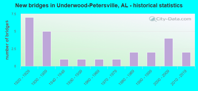
- New bridges - historical statistics
- 71920-1929
- 51930-1939
- 11940-1949
- 11950-1959
- 11960-1969
- 11970-1979
- 21980-1989
- 21990-1999
- 42000-2009
- 22010-2019

- Reconstructed bridges - Historical Statistics
- 41930-1939
- 01940-1949
- 01950-1959
- 11960-1969
- 11970-1979
- 01980-1989
- 11990-1999


- Bridge Condition - Deck
- 28.6%Very good
- 7.1%Good
- 21.4%Satisfactory
- 35.7%Fair
- 7.1%Serious

- Bridge Condition - Superstructure
- 21.4%Very good
- 14.3%Good
- 28.6%Satisfactory
- 28.6%Fair
- 7.1%Poor

- Bridge Condition - Substructure
- 14.3%Very good
- 14.3%Good
- 28.6%Satisfactory
- 35.7%Fair
- 7.1%Serious

- Bridge Condition - Channel
- 11.5%Very good
- 26.9%Good
- 50.0%Satisfactory
- 7.7%Fair
- 3.8%Poor

- Bridge Condition - Culverts
- 33.3%Very good
- 16.7%Good
- 41.7%Satisfactory
- 8.3%Fair
Find on map >> Show street view
Structure Number: 1434, Location: 2.7 MI N INT SR 157 (Lat: 34.858544, Lng: -87.735725), Route carried "on" structure: County highway 16, Year Built: 1936, Status: Closed, Structure Length: 5.18m (16.99ft), Average Daily Traffic: 982 (year 2001), Truck Traffic: 10%, Average Future Daily Traffic: 1,459 (year 2032), Features Intersected: CYPRESS CREEK
Minimum Vertical Clearance: 30+ m (98+ ft), Kilometerpoint: 0.010, Lanes on structure: 2, Owner: County Highway Agency, Approaching Roadway Width: 7.3m (24.0ft), Material/Design: Concrete, Design/Construction: Tee Beam, Number Of Spans In Main Unit: 7, Length of Maximum Span: 7.6m (24.9ft), Curb-To-Curb Width: 5.8m (19.0ft), Out-to-Out Width: 5.8m (19.0ft)
Condition: Deck: Serious, Superstructure: Poor, Substructure: Serious, Channel: Satisfactory, Waterway Adequacy: High priority of corrective action, Approach Roadway Alignment: Meets minimum limits, Bridge Posting: Required (Relationship of Operating Rating to Maximum Legal Load: > 39.9% below), Length Of Structure Improvement: 6.20m (20.34ft), Designated Inspection Frequency: Every 24 months, Other Special Inspection Frequency: Every 3 months, Inspection Date: October 2015, Other Special Inspection Date: April 2017, Bridge Improvement Cost: $808,000, Roadway Improvement Cost: $81,000, Total Project Cost: $889,000 ( Estimate for 2022), Deck Structure Type: Concrete Cast-file-Place, Wearing Surface/Protective System: Wearing Surface: Bituminous
Find on map >> Show street view
Structure Number: 1685, Location: 1.4 MI. N. SR 106 (Lat: 31.577617, Lng: -86.281567), Route carried "on" structure: US 29, Year Built: 1923, Year Reconstructed: 1938, Status: Open, Structure Length: 0.64m (2.10ft), Average Daily Traffic: 1,980 (year 2013), Truck Traffic: 15%, Average Future Daily Traffic: 2,698 (year 2033), Design Load: H 15, Features Intersected: POSSUM BRANCH
Minimum Vertical Clearance: 30+ m (98+ ft), Kilometerpoint: 114.255, Lanes on structure: 2, Owner: State Highway Agency, Approaching Roadway Width: 10.7m (35.1ft), Material/Design: Concrete, Design/Construction: Culvert, Number Of Spans In Main Unit: 2, Length of Maximum Span: 3.0m (9.8ft)
Condition: Channel: Fair, Culverts: Good, Operating Rating: 50.7 metric tons, Method Used To Determine Operating Rating: Load Factor (LF), Inventory Rating: 30.4 metric tons, Method Used To Determine Inventory Rating: Load Factor (LF), Structural Evaluation: Better than present minimum criteria, Waterway Adequacy: Equal to present desirable criteria, Approach Roadway Alignment: Equal to present desirable criteria, Length Of Structure Improvement: 1.26m (4.13ft), Designated Inspection Frequency: Every 24 months, Inspection Date: September 2021, Bridge Improvement Cost: $277,000, Roadway Improvement Cost: $28,000, Total Project Cost: $305,000 ( Estimate for 2022)
Find on map >> Show street view
Structure Number: 1691, Location: 3.5 MI N JCT SR 14 (Lat: 33.180083, Lng: -88.104950), Route carried "on" structure: State highway 17, Year Built: 1926, Year Reconstructed: 1995, Status: Open, Structure Length: 0.64m (2.10ft), Average Daily Traffic: 3,429 (year 2020), Truck Traffic: 7%, Average Future Daily Traffic: 3,224 (year 2040), Design Load: H 15, Features Intersected: Lubbub Creek Branch
Minimum Vertical Clearance: 30+ m (98+ ft), Kilometerpoint: 312.609, Lanes on structure: 2, Base Highway Network: Yes, Owner: State Highway Agency, Approaching Roadway Width: 8.8m (28.9ft), Material/Design: Concrete, Design/Construction: Culvert, Number Of Spans In Main Unit: 2, Length of Maximum Span: 3.0m (9.8ft)
Condition: Channel: Satisfactory, Culverts: Satisfactory, Operating Rating: 88.9 metric tons, Method Used To Determine Operating Rating: Load Factor (LF), Inventory Rating: 60.0 metric tons, Method Used To Determine Inventory Rating: Load Factor (LF), Structural Evaluation: Equal to present minimum criteria, Waterway Adequacy: Equal to present minimum criteria, Approach Roadway Alignment: Equal to present desirable criteria, Length Of Structure Improvement: 1.26m (4.13ft), Designated Inspection Frequency: Every 24 months, Inspection Date: Febuary 2022, Bridge Improvement Cost: $320,000, Roadway Improvement Cost: $32,000, Total Project Cost: $352,000 ( Estimate for 2022)
Find on map >> Show street view
Structure Number: 1692, Location: 5.1 MI N JCT SR 14 (Lat: 33.201850, Lng: -88.102317), Route carried "on" structure: State highway 17, Year Built: 1926, Year Reconstructed: 1938, Status: Open, Structure Length: 0.64m (2.10ft), Average Daily Traffic: 3,429 (year 2020), Truck Traffic: 7%, Average Future Daily Traffic: 3,908 (year 2038), Design Load: H 15, Features Intersected: Lubbub Creek Branch
Minimum Vertical Clearance: 30+ m (98+ ft), Kilometerpoint: 315.076, Lanes on structure: 2, Base Highway Network: Yes, Owner: State Highway Agency, Approaching Roadway Width: 9.1m (29.9ft), Material/Design: Concrete, Design/Construction: Culvert, Number Of Spans In Main Unit: 2, Length of Maximum Span: 3.0m (9.8ft)
Condition: Channel: Satisfactory, Culverts: Satisfactory, Operating Rating: 85.8 metric tons, Method Used To Determine Operating Rating: Load Factor (LF), Inventory Rating: 51.4 metric tons, Method Used To Determine Inventory Rating: Load Factor (LF), Structural Evaluation: Equal to present minimum criteria, Waterway Adequacy: Somewhat better than minimum adequacy, Approach Roadway Alignment: Better than present minimum criteria, Length Of Structure Improvement: 1.26m (4.13ft), Designated Inspection Frequency: Every 24 months, Inspection Date: Febuary 2022, Bridge Improvement Cost: $320,000, Roadway Improvement Cost: $32,000, Total Project Cost: $352,000 ( Estimate for 2022)
Find on map >> Show street view
Structure Number: 1693, Location: 3.0 MI S JCT SR 86 (Lat: 33.226633, Lng: -88.094783), Route carried "on" structure: State highway 17, Year Built: 1926, Year Reconstructed: 1982, Status: Open, Structure Length: 0.98m (3.22ft), Average Daily Traffic: 2,810 (year 2020), Truck Traffic: 8%, Average Future Daily Traffic: 3,908 (year 2038), Design Load: H 15, Features Intersected: Lubbub Creek Branch
Minimum Vertical Clearance: 30+ m (98+ ft), Kilometerpoint: 317.931, Lanes on structure: 2, Base Highway Network: Yes, Owner: State Highway Agency, Approaching Roadway Width: 9.4m (30.8ft), Material/Design: Concrete, Design/Construction: Culvert, Number Of Spans In Main Unit: 3, Length of Maximum Span: 3.0m (9.8ft)
Condition: Channel: Satisfactory, Culverts: Satisfactory, Operating Rating: 88.9 metric tons, Method Used To Determine Operating Rating: Load Factor (LF), Inventory Rating: 61.1 metric tons, Method Used To Determine Inventory Rating: Load Factor (LF), Structural Evaluation: Equal to present minimum criteria, Waterway Adequacy: Equal to present minimum criteria, Approach Roadway Alignment: Better than present minimum criteria, Length Of Structure Improvement: 1.64m (5.38ft), Designated Inspection Frequency: Every 24 months, Inspection Date: Febuary 2022, Bridge Improvement Cost: $418,000, Roadway Improvement Cost: $42,000, Total Project Cost: $460,000 ( Estimate for 2022)
Find on map >> Show street view
Structure Number: 1694, Location: 1.5 MI S JCT SR 86 (Lat: 33.248333, Lng: -88.093450), Route carried "on" structure: State highway 17, Year Built: 1926, Year Reconstructed: 1938, Status: Open, Structure Length: 0.64m (2.10ft), Average Daily Traffic: 2,810 (year 2020), Truck Traffic: 8%, Average Future Daily Traffic: 3,134 (year 2038), Design Load: H 15, Features Intersected: Lubbub Creek Branch
Minimum Vertical Clearance: 30+ m (98+ ft), Kilometerpoint: 320.345, Lanes on structure: 2, Base Highway Network: Yes, Owner: State Highway Agency, Approaching Roadway Width: 9.4m (30.8ft), Material/Design: Concrete, Design/Construction: Culvert, Number Of Spans In Main Unit: 2, Length of Maximum Span: 3.0m (9.8ft)
Condition: Channel: Satisfactory, Culverts: Fair, Operating Rating: 88.9 metric tons, Method Used To Determine Operating Rating: Load Factor (LF), Inventory Rating: 88.9 metric tons, Method Used To Determine Inventory Rating: Load Factor (LF), Structural Evaluation: Somewhat better than minimum adequacy, Waterway Adequacy: Equal to present minimum criteria, Approach Roadway Alignment: Better than present minimum criteria, Length Of Structure Improvement: 1.26m (4.13ft), Designated Inspection Frequency: Every 24 months, Inspection Date: Febuary 2022, Bridge Improvement Cost: $357,000, Roadway Improvement Cost: $36,000, Total Project Cost: $393,000 ( Estimate for 2022)
Find on map >> Show street view
Structure Number: 1695, Location: 0.2 MI.E.OF AL.245 JCT. (Lat: 31.832617, Lng: -86.602683), Route carried "on" structure: State highway 10, Year Built: 1927, Year Reconstructed: 1938, Status: Temporarily open, Structure Length: 5.39m (17.68ft), Average Daily Traffic: 7,550 (year 2013), Truck Traffic: 13%, Average Future Daily Traffic: 9,833 (year 2033), Design Load: H 15, Features Intersected: PERSIMMON CREEK
Minimum Vertical Clearance: 30+ m (98+ ft), Kilometerpoint: 200.684, Lanes on structure: 2, Owner: State Highway Agency, Approaching Roadway Width: 12.2m (40.0ft), Material/Design: Steel, Design/Construction: Stringer/Multi-beam, Number Of Spans In Main Unit: 8, Length of Maximum Span: 12.2m (40.0ft), Curb-To-Curb Width: 7.3m (24.0ft), Out-to-Out Width: 7.6m (24.9ft)
Condition: Deck: Fair, Superstructure: Satisfactory, Substructure: Fair, Channel: Poor, Operating Rating: 51.3 metric tons, Method Used To Determine Operating Rating: Load Factor (LF), Inventory Rating: 30.8 metric tons, Method Used To Determine Inventory Rating: Load Factor (LF), Structural Evaluation: Somewhat better than minimum adequacy, Deck Geometry: High priority of replacement, Waterway Adequacy: Superior to present desirable criteria, Approach Roadway Alignment: Better than present minimum criteria, Length Of Structure Improvement: 6.42m (21.06ft), Designated Inspection Frequency: Every 24 months, Inspection Date: August 2020, Bridge Improvement Cost: $1,056,000, Roadway Improvement Cost: $106,000, Total Project Cost: $1,162,000 ( Estimate for 2022), Deck Structure Type: Concrete Cast-file-Place, Wearing Surface/Protective System: Wearing Surface: Bituminous
Find on map >> Show street view
Structure Number: 1698, Location: CR 5 (Lat: 33.872517, Lng: -86.960969), Route carried "on" structure: County highway , Year Built: 1938, Status: Open, Structure Length: 1.22m (4.00ft), Average Daily Traffic: 50 (year 1991), Average Future Daily Traffic: 75 (year 2035), Features Intersected: CREEK, Facility Carried by Structure: County Road 5
Minimum Vertical Clearance: 30+ m (98+ ft), Kilometerpoint: 0.010, Lanes on structure: 2, Owner: County Highway Agency, Approaching Roadway Width: 5.5m (18.0ft), Skew: 1 degrees, Material/Design: Steel, Design/Construction: Stringer/Multi-beam, Number Of Spans In Main Unit: 2, Length of Maximum Span: 8.5m (27.9ft), Curb-To-Curb Width: 6.0m (19.7ft), Out-to-Out Width: 6.1m (20.0ft)
Condition: Deck: Fair, Superstructure: Fair, Substructure: Satisfactory, Channel: Satisfactory, Operating Rating: 43.5 metric tons, Method Used To Determine Operating Rating: Load Factor (LF), Inventory Rating: 26.1 metric tons, Method Used To Determine Inventory Rating: Load Factor (LF), Structural Evaluation: Somewhat better than minimum adequacy, Deck Geometry: Meets minimum limits, Waterway Adequacy: Meets minimum limits, Approach Roadway Alignment: Somewhat better than minimum adequacy, Length Of Structure Improvement: 1.89m (6.20ft), Designated Inspection Frequency: Every 24 months, Inspection Date: October 2020, Bridge Improvement Cost: $259,000, Roadway Improvement Cost: $26,000, Total Project Cost: $285,000 ( Estimate for 2022), Deck Structure Type: Concrete Cast-file-Place
Find on map >> Show street view
Structure Number: 1751, Location: .8 M. S. OF YORK (Lat: 32.476258, Lng: -88.292306), Route carried "on" structure: State highway 17, Year Built: 1938, Status: Open, Structure Length: 4.05m (13.29ft), Average Daily Traffic: 2,580 (year 2013), Truck Traffic: 13%, Average Future Daily Traffic: 3,327 (year 2039), Design Load: H 15, Features Intersected: ALAMUCHEE * TOOMSUBA CR
Minimum Vertical Clearance: 30+ m (98+ ft), Kilometerpoint: 224.429, Lanes on structure: 2, Owner: State Highway Agency, Approaching Roadway Width: 8.8m (28.9ft), Material/Design: Steel continuous, Design/Construction: Stringer/Multi-beam, Number Of Spans In Main Unit: 6, Length of Maximum Span: 6.7m (22.0ft), Curb-To-Curb Width: 7.3m (24.0ft), Out-to-Out Width: 7.6m (24.9ft)
Condition: Deck: Fair, Superstructure: Fair, Substructure: Satisfactory, Channel: Satisfactory, Operating Rating: 63.0 metric tons, Method Used To Determine Operating Rating: Load Factor (LF), Inventory Rating: 37.7 metric tons, Method Used To Determine Inventory Rating: Load Factor (LF), Structural Evaluation: Somewhat better than minimum adequacy, Deck Geometry: High priority of replacement, Waterway Adequacy: Equal to present minimum criteria, Approach Roadway Alignment: Equal to present desirable criteria, Length Of Structure Improvement: 5.01m (16.44ft), Designated Inspection Frequency: Every 24 months, Inspection Date: January 2021, Bridge Improvement Cost: $824,000, Roadway Improvement Cost: $82,000, Total Project Cost: $906,000 ( Estimate for 2022), Deck Structure Type: Concrete Cast-file-Place
Find on map >> Show street view
Structure Number: 1752, Location: YORK (Lat: 32.477814, Lng: -88.293639), Route carried "on" structure: State highway 17, Year Built: 1938, Status: Open, Structure Length: 34.92m (114.57ft), Average Daily Traffic: 2,580 (year 2013), Truck Traffic: 13%, Average Future Daily Traffic: 3,327 (year 2033), Design Load: H 15, Features Intersected: ALAMUCHEE/TOOMSUBA CREEK
Minimum Vertical Clearance: 30+ m (98+ ft), Kilometerpoint: 224.640, Lanes on structure: 2, Owner: State Highway Agency, Approaching Roadway Width: 9.8m (32.2ft), Skew: 9 degrees, Material/Design: Steel, Design/Construction: Stringer/Multi-beam, Number Of Spans In Main Unit: 2, Number Of Approach Spans: 49, Length of Maximum Span: 12.2m (40.0ft), Curb-To-Curb Width: 7.3m (24.0ft), Out-to-Out Width: 7.6m (24.9ft)
Condition: Deck: Fair, Superstructure: Fair, Substructure: Fair, Channel: Fair, Operating Rating: 49.7 metric tons, Method Used To Determine Operating Rating: Load Factor (LF), Inventory Rating: 29.8 metric tons, Method Used To Determine Inventory Rating: Load Factor (LF), Structural Evaluation: Somewhat better than minimum adequacy, Deck Geometry: High priority of replacement, Waterway Adequacy: Equal to present minimum criteria, Approach Roadway Alignment: High priority of corrective action, Length Of Structure Improvement: 34.92m (114.57ft), Designated Inspection Frequency: Every 24 months, Inspection Date: January 2021, Bridge Improvement Cost: $5,747,000, Roadway Improvement Cost: $575,000, Total Project Cost: $6,322,000 ( Estimate for 2022), Deck Structure Type: Concrete Cast-file-Place
Find on map >> Show street view
Structure Number: 1755, Location: 3.9 MI E MISS STATE LINE (Lat: 33.734650, Lng: -88.205183), Route carried "on" structure: State highway 18, Year Built: 1938, Status: Open, Structure Length: 0.67m (2.20ft), Average Daily Traffic: 2,421 (year 2020), Truck Traffic: 8%, Average Future Daily Traffic: 3,038 (year 2040), Design Load: H 15, Features Intersected: Lubbub Creek Branch
Minimum Vertical Clearance: 30+ m (98+ ft), Kilometerpoint: 6.354, Lanes on structure: 2, Base Highway Network: Yes, Owner: State Highway Agency, Approaching Roadway Width: 8.2m (26.9ft), Skew: 4 degrees, Material/Design: Concrete, Design/Construction: Culvert, Number Of Spans In Main Unit: 2, Length of Maximum Span: 3.4m (11.2ft)
Condition: Channel: Satisfactory, Culverts: Good, Operating Rating: 88.9 metric tons, Method Used To Determine Operating Rating: Load Factor (LF), Inventory Rating: 88.9 metric tons, Method Used To Determine Inventory Rating: Load Factor (LF), Structural Evaluation: Better than present minimum criteria, Waterway Adequacy: Equal to present minimum criteria, Approach Roadway Alignment: Better than present minimum criteria, Length Of Structure Improvement: 1.30m (4.27ft), Designated Inspection Frequency: Every 24 months, Inspection Date: June 2020, Bridge Improvement Cost: $398,000, Roadway Improvement Cost: $40,000, Total Project Cost: $438,000 ( Estimate for 2022)
Find on map >> Show street view
Structure Number: 3013, Location: 2.5 MI N SR 157 (Lat: 34.908847, Lng: -87.704289), Route carried "on" structure: County highway 7, Year Built: 1947, Status: Open, Structure Length: 5.58m (18.31ft), Average Daily Traffic: 250 (year 1989), Truck Traffic: 10%, Average Future Daily Traffic: 500 (year 2032), Features Intersected: LITTLE CYPRESS CREEK
Minimum Vertical Clearance: 30+ m (98+ ft), Kilometerpoint: 0.010, Lanes on structure: 2, Owner: County Highway Agency, Approaching Roadway Width: 7.6m (24.9ft), Material/Design: Concrete, Design/Construction: Tee Beam, Number Of Spans In Main Unit: 5, Length of Maximum Span: 9.4m (30.8ft), Curb or Sidewalk Widths: Left: 0.3m (1.0ft), Right: 0.3m (1.0ft), Curb-To-Curb Width: 6.0m (19.7ft), Out-to-Out Width: 6.1m (20.0ft)
Condition: Deck: Satisfactory, Superstructure: Satisfactory, Substructure: Fair, Channel: Good, Operating Rating: 43.5 metric tons, Method Used To Determine Operating Rating: Field evaluation and documented engineering judgment, Inventory Rating: 32.7 metric tons, Method Used To Determine Inventory Rating: Field evaluation and documented engineering judgment, Structural Evaluation: Somewhat better than minimum adequacy, Waterway Adequacy: Equal to present desirable criteria, Approach Roadway Alignment: Meets minimum limits, Length Of Structure Improvement: 6.62m (21.72ft), Designated Inspection Frequency: Every 24 months, Underwater Inspection Frequency: Every 48 months, Inspection Date: May 2020, Underwater Inspection Date: April 2018, Bridge Improvement Cost: $907,000, Roadway Improvement Cost: $91,000, Total Project Cost: $998,000 ( Estimate for 2022), Deck Structure Type: Concrete Cast-file-Place
Find on map >> Show street view
Structure Number: 384, Location: 0.2 MI W INT SR 17 (Lat: 34.905803, Lng: -87.673481), Route carried "on" structure: County highway 124, Year Built: 1950, Status: Posted for load, Structure Length: 0.82m (2.69ft), Average Daily Traffic: 664 (year 2001), Truck Traffic: 10%, Average Future Daily Traffic: 987 (year 2031), Features Intersected: CHISHOLM BRANCH
Minimum Vertical Clearance: 30+ m (98+ ft), Kilometerpoint: 0.010, Lanes on structure: 2, Owner: County Highway Agency, Approaching Roadway Width: 6.7m (22.0ft), Material/Design: Steel, Design/Construction: Stringer/Multi-beam, Number Of Spans In Main Unit: 1, Length of Maximum Span: 8.2m (26.9ft), Curb or Sidewalk Widths: Left: 0.2m (0.7ft), Right: 0.2m (0.7ft), Curb-To-Curb Width: 7.4m (24.3ft), Out-to-Out Width: 8.0m (26.2ft)
Condition: Deck: Fair, Superstructure: Fair, Substructure: Fair, Channel: Satisfactory, Operating Rating: 9.3 metric tons, Method Used To Determine Operating Rating: Allowable Stress (AS), Inventory Rating: 2.6 metric tons, Method Used To Determine Inventory Rating: Allowable Stress (AS), Structural Evaluation: High priority of replacement, Waterway Adequacy: Better than present minimum criteria, Approach Roadway Alignment: Better than present minimum criteria, Bridge Posting: Required (Relationship of Operating Rating to Maximum Legal Load: > 39.9% below), Length Of Structure Improvement: 1.48m (4.86ft), Designated Inspection Frequency: Every 24 months, Other Special Inspection Frequency: Every 12 months, Inspection Date: January 2021, Other Special Inspection Date: January 2022, Bridge Improvement Cost: $264,000, Roadway Improvement Cost: $26,000, Total Project Cost: $290,000 ( Estimate for 2022), Deck Structure Type: Concrete Cast-file-Place, Wearing Surface/Protective System: Wearing Surface: Bituminous
Find on map >> Show street view
Structure Number: 9829, Location: 6 MI S AL & TN ST LINE (Lat: 34.910633, Lng: -87.669806), Route carried "on" structure: State highway 17, Year Built: 1921, Year Reconstructed: 1969, Status: Open, Structure Length: 0.64m (2.10ft), Average Daily Traffic: 6,850 (year 2021), Truck Traffic: 5%, Average Future Daily Traffic: 8,834 (year 2033), Design Load: H 15, Features Intersected: BRANCH
Minimum Vertical Clearance: 7.56m (24.80ft), Kilometerpoint: 547.368, Lanes on structure: 2, Owner: State Highway Agency, Approaching Roadway Width: 7.6m (24.9ft), Material/Design: Concrete, Design/Construction: Slab, Number Of Spans In Main Unit: 1, Length of Maximum Span: 6.4m (21.0ft), Curb or Sidewalk Widths: Left: 0.3m (1.0ft), Right: 0.3m (1.0ft), Curb-To-Curb Width: 11.5m (37.7ft), Out-to-Out Width: 12.1m (39.7ft)
Condition: Deck: Satisfactory, Superstructure: Satisfactory, Substructure: Satisfactory, Channel: Very good, Operating Rating: 49.7 metric tons, Method Used To Determine Operating Rating: Load Factor (LF), Inventory Rating: 29.8 metric tons, Method Used To Determine Inventory Rating: Load Factor (LF), Structural Evaluation: Equal to present minimum criteria, Deck Geometry: Meets minimum limits, Waterway Adequacy: Equal to present desirable criteria, Approach Roadway Alignment: Equal to present desirable criteria, Length Of Structure Improvement: 1.26m (4.13ft), Designated Inspection Frequency: Every 24 months, Inspection Date: January 2021, Bridge Improvement Cost: $337,000, Roadway Improvement Cost: $34,000, Total Project Cost: $371,000 ( Estimate for 2022), Deck Structure Type: Concrete Cast-file-Place, Wearing Surface/Protective System: Wearing Surface: Bituminous
Find on map >> Show street view
Structure Number: 11696, Location: 4 M N JCT SR 157 & SR 133 (Lat: 34.882200, Lng: -87.720700), Route carried "on" structure: State highway 157, Year Built: 1976, Status: Open, Structure Length: 8.08m (26.51ft), Average Daily Traffic: 5,850 (year 2021), Truck Traffic: 2%, Average Future Daily Traffic: 7,012 (year 2033), Design Load: HS 20, Features Intersected: LITTLE CYPRESS CREEK
Minimum Vertical Clearance: 30+ m (98+ ft), Kilometerpoint: 129.702, Lanes on structure: 2, Owner: State Highway Agency, Approaching Roadway Width: 7.2m (23.6ft), Material/Design: Steel continuous, Design/Construction: Stringer/Multi-beam, Number Of Spans In Main Unit: 3, Number Of Approach Spans: 1, Length of Maximum Span: 24.4m (80.1ft), Curb or Sidewalk Widths: Left: 0.4m (1.3ft), Right: 0.4m (1.3ft), Curb-To-Curb Width: 13.4m (44.0ft), Out-to-Out Width: 14.2m (46.6ft)
Condition: Deck: Good, Superstructure: Satisfactory, Substructure: Good, Channel: Satisfactory, Operating Rating: 45.6 metric tons, Method Used To Determine Operating Rating: Load Factor (LF), Inventory Rating: 27.3 metric tons, Method Used To Determine Inventory Rating: Load Factor (LF), Structural Evaluation: Equal to present minimum criteria, Deck Geometry: Equal to present minimum criteria, Waterway Adequacy: Equal to present desirable criteria, Approach Roadway Alignment: Equal to present desirable criteria, Length Of Structure Improvement: 9.08m (29.79ft), Designated Inspection Frequency: Every 24 months, Inspection Date: October 2021, Bridge Improvement Cost: $2,866,000, Roadway Improvement Cost: $287,000, Total Project Cost: $3,153,000 ( Estimate for 2022), Deck Structure Type: Concrete Cast-file-Place
Find on map >> Show street view
Structure Number: 13, Location: 4.5 M N JCT SR 20 & SR133 (Lat: 34.876733, Lng: -87.777794), Route carried "on" structure: State highway 20, Year Built: 1983, Status: Open, Structure Length: 7.25m (23.79ft), Average Daily Traffic: 5,740 (year 2020), Truck Traffic: 10%, Average Future Daily Traffic: 7,731 (year 2033), Design Load: HS 20, Features Intersected: BURCHAM CREEK RELIEF
Minimum Vertical Clearance: 30+ m (98+ ft), Kilometerpoint: 20.395, Lanes on structure: 2, Base Highway Network: Yes, Owner: State Highway Agency, Approaching Roadway Width: 12.7m (41.7ft), Skew: 3 degrees, Material/Design: Prestressed concrete continuous, Design/Construction: Stringer/Multi-beam, Number Of Spans In Main Unit: 7, Length of Maximum Span: 10.4m (34.1ft), Curb or Sidewalk Widths: Left: 0.2m (0.7ft), Right: 0.2m (0.7ft), Curb-To-Curb Width: 13.4m (44.0ft), Out-to-Out Width: 14.2m (46.6ft)
Condition: Deck: Satisfactory, Superstructure: Good, Substructure: Good, Channel: Good, Operating Rating: 50.1 metric tons, Method Used To Determine Operating Rating: Load Factor (LF), Inventory Rating: 29.9 metric tons, Method Used To Determine Inventory Rating: Load Factor (LF), Structural Evaluation: Better than present minimum criteria, Deck Geometry: Equal to present minimum criteria, Waterway Adequacy: Equal to present desirable criteria, Approach Roadway Alignment: Equal to present desirable criteria, Length Of Structure Improvement: 8.28m (27.17ft), Designated Inspection Frequency: Every 24 months, Inspection Date: November 2020, Bridge Improvement Cost: $2,611,000, Roadway Improvement Cost: $261,000, Total Project Cost: $2,872,000 ( Estimate for 2022), Deck Structure Type: Concrete Cast-file-Place
Find on map >> Show street view
Structure Number: 13581, Location: 0.5 MI W CO 9 (Lat: 34.902650, Lng: -87.770044), Route carried "on" structure: County highway 6, Year Built: 1985, Status: Posted for load, Structure Length: 5.18m (16.99ft), Average Daily Traffic: 500 (year 1989), Truck Traffic: 10%, Average Future Daily Traffic: 1,000 (year 2031), Features Intersected: MIDDLE CYPRESS RELIEF
Minimum Vertical Clearance: 30+ m (98+ ft), Kilometerpoint: 0.010, Lanes on structure: 2, Owner: County Highway Agency, Approaching Roadway Width: 6.7m (22.0ft), Material/Design: Concrete, Design/Construction: Channel Beam, Number Of Spans In Main Unit: 6, Length of Maximum Span: 10.4m (34.1ft), Curb or Sidewalk Widths: Left: 0.2m (0.7ft), Right: 0.2m (0.7ft), Curb-To-Curb Width: 8.5m (27.9ft), Out-to-Out Width: 9.3m (30.5ft)
Condition: Deck: Very good, Superstructure: Good, Substructure: Fair, Channel: Good, Operating Rating: 28.8 metric tons, Method Used To Determine Operating Rating: Allowable Stress (AS), Inventory Rating: 13.1 metric tons, Method Used To Determine Inventory Rating: Allowable Stress (AS), Structural Evaluation: Meets minimum limits, Waterway Adequacy: Somewhat better than minimum adequacy, Approach Roadway Alignment: Equal to present desirable criteria, Bridge Posting: Required (Relationship of Operating Rating to Maximum Legal Load: 30.0 - 39.9% below), Length Of Structure Improvement: 6.20m (20.34ft), Designated Inspection Frequency: Every 24 months, Other Special Inspection Frequency: Every 12 months, Inspection Date: November 2020, Other Special Inspection Date: November 2021, Bridge Improvement Cost: $1,276,000, Roadway Improvement Cost: $128,000, Total Project Cost: $1,404,000 ( Estimate for 2022), Deck Structure Type: Concrete Precast Panels
Find on map >> Show street view
Structure Number: 16543, Location: 0.8 MI W INT CO RT 7 (Lat: 34.902350, Lng: -87.715569), Route carried "on" structure: County highway 6, Year Built: 1995, Status: Open, Structure Length: 0.79m (2.59ft), Average Daily Traffic: 255 (year 1989), Truck Traffic: 10%, Average Future Daily Traffic: 315 (year 2032), Design Load: HS 20, Features Intersected: IJAMS BRANCH
Minimum Vertical Clearance: 30+ m (98+ ft), Kilometerpoint: 0.010, Lanes on structure: 2, Owner: County Highway Agency, Approaching Roadway Width: 7.3m (24.0ft), Material/Design: Concrete, Design/Construction: Culvert, Number Of Spans In Main Unit: 2, Length of Maximum Span: 3.7m (12.1ft), Curb or Sidewalk Widths: Left: 0.2m (0.7ft), Right: 0.2m (0.7ft), Out-to-Out Width: 12.8m (42.0ft)
Condition: Channel: Satisfactory, Culverts: Very good, Operating Rating: 88.9 metric tons, Method Used To Determine Operating Rating: Load Factor (LF), Inventory Rating: 68.0 metric tons, Method Used To Determine Inventory Rating: Load Factor (LF), Structural Evaluation: Equal to present desirable criteria, Waterway Adequacy: Better than present minimum criteria, Approach Roadway Alignment: Somewhat better than minimum adequacy, Length Of Structure Improvement: 1.44m (4.72ft), Designated Inspection Frequency: Every 24 months, Inspection Date: January 2021, Bridge Improvement Cost: $350,000, Roadway Improvement Cost: $35,000, Total Project Cost: $385,000 ( Estimate for 2022), Wearing Surface/Protective System: Wearing Surface: Bituminous
Find on map >> Show street view
Structure Number: 17273, Location: 1.6 MI W INT AL 17 (Lat: 34.949100, Lng: -87.694792), Route carried "on" structure: County highway 8, Year Built: 2000, Status: Open, Structure Length: 5.40m (17.72ft), Average Daily Traffic: 822 (year 2001), Average Future Daily Traffic: 1,174 (year 2028), Design Load: HS 20, Features Intersected: LITTLE CYPRESS CREEK
Minimum Vertical Clearance: 30+ m (98+ ft), Kilometerpoint: 0.000, Lanes on structure: 2, Toll: Toll bridge is a segment, Owner: County Highway Agency, Approaching Roadway Width: 6.1m (20.0ft), Material/Design: Prestressed concrete, Design/Construction: Stringer/Multi-beam, Number Of Spans In Main Unit: 3, Length of Maximum Span: 18.0m (59.1ft), Curb or Sidewalk Widths: Left: 0.4m (1.3ft), Right: 0.4m (1.3ft), Curb-To-Curb Width: 9.0m (29.5ft), Out-to-Out Width: 9.8m (32.2ft)
Condition: Deck: Very good, Superstructure: Very good, Substructure: Very good, Channel: Very good, Operating Rating: 71.8 metric tons, Method Used To Determine Operating Rating: Load Factor (LF), Inventory Rating: 43.0 metric tons, Method Used To Determine Inventory Rating: Load Factor (LF), Structural Evaluation: Equal to present desirable criteria, Deck Geometry: Somewhat better than minimum adequacy, Waterway Adequacy: Equal to present desirable criteria, Approach Roadway Alignment: Equal to present minimum criteria, Length Of Structure Improvement: 6.43m (21.10ft), Designated Inspection Frequency: Every 24 months, Inspection Date: May 2020, Bridge Improvement Cost: $1,411,000, Roadway Improvement Cost: $141,000, Total Project Cost: $1,552,000 ( Estimate for 2022), Deck Structure Type: Concrete Cast-file-Place
Find on map >> Show street view
Structure Number: 1753, Location: 1.0 MI. W OF NICHBURG (Lat: 31.484911, Lng: -87.157114), Route carried "on" structure: County highway 20, Year Built: 1998, Status: Open, Structure Length: 1.78m (5.84ft), Average Daily Traffic: 720 (year 1997), Truck Traffic: 6%, Average Future Daily Traffic: 1,237 (year 2035), Design Load: HS 20, Features Intersected: TRIB. TO BURNT CORN CK
Minimum Vertical Clearance: 30+ m (98+ ft), Kilometerpoint: 0.000, Lanes on structure: 2, Owner: County Highway Agency, Approaching Roadway Width: 6.2m (20.3ft), Material/Design: Concrete, Design/Construction: Culvert, Number Of Spans In Main Unit: 4, Length of Maximum Span: 4.2m (13.8ft), Curb-To-Curb Width: 11.6m (38.1ft), Out-to-Out Width: 12.2m (40.0ft)
Condition: Channel: Good, Culverts: Satisfactory, Operating Rating: 68.9 metric tons, Method Used To Determine Operating Rating: Load Factor (LF), Inventory Rating: 41.4 metric tons, Method Used To Determine Inventory Rating: Load Factor (LF), Structural Evaluation: Equal to present minimum criteria, Deck Geometry: Better than present minimum criteria, Waterway Adequacy: Equal to present minimum criteria, Approach Roadway Alignment: Better than present minimum criteria, Length Of Structure Improvement: 2.49m (8.17ft), Designated Inspection Frequency: Every 24 months, Inspection Date: Febuary 2022, Bridge Improvement Cost: $574,000, Roadway Improvement Cost: $57,000, Total Project Cost: $631,000 ( Estimate for 2022), Deck Structure Type: Concrete Cast-file-Place, Wearing Surface/Protective System: Wearing Surface: Bituminous
Find on map >> Show street view
Structure Number: 1754, Location: 2 MI N. CULLMAN COUNTY (Lat: 34.340442, Lng: -86.945656), Route carried "on" structure: ServiceCounty highway B0047, Year Built: 1960, Status: Open, Structure Length: 0.91m (2.99ft), Average Daily Traffic: 290 (year 2007), Truck Traffic: 5%, Average Future Daily Traffic: 558 (year 2040), Design Load: HS 20, Features Intersected: JONES BRANCH, Facility Carried by Structure: WEST LACON ROAD
Minimum Vertical Clearance: 8.00m (26.25ft), Kilometerpoint: 0.000, Lanes on structure: 2, Owner: County Highway Agency, Approaching Roadway Width: 6.4m (21.0ft), Skew: 3 degrees, Material/Design: Concrete continuous, Design/Construction: Culvert, Number Of Spans In Main Unit: 3, Length of Maximum Span: 2.8m (9.2ft), Curb or Sidewalk Widths: Left: 0.2m (0.7ft), Right: 0.2m (0.7ft), Curb-To-Curb Width: 10.2m (33.5ft), Out-to-Out Width: 10.8m (35.4ft)
Condition: Channel: Satisfactory, Culverts: Satisfactory, Operating Rating: 45.7 metric tons, Method Used To Determine Operating Rating: Load Factor (LF), Inventory Rating: 27.5 metric tons, Method Used To Determine Inventory Rating: Load Factor (LF), Structural Evaluation: Equal to present minimum criteria, Deck Geometry: Better than present minimum criteria, Waterway Adequacy: Better than present minimum criteria, Approach Roadway Alignment: Equal to present desirable criteria, Length Of Structure Improvement: 1.58m (5.18ft), Designated Inspection Frequency: Every 24 months, Inspection Date: December 2020, Bridge Improvement Cost: $365,000, Roadway Improvement Cost: $37,000, Total Project Cost: $402,000 ( Estimate for 2022)
Find on map >> Show street view
Structure Number: 18553, Location: 1.5 MI N INT SR 157 (Lat: 34.892617, Lng: -87.704506), Route carried "on" structure: County highway 7, Year Built: 2003, Status: Open, Structure Length: 1.76m (5.77ft), Average Daily Traffic: 1,129 (year 2002), Average Future Daily Traffic: 1,678 (year 2032), Design Load: HS 20, Features Intersected: CHISHOLM BRANCH
Minimum Vertical Clearance: 30+ m (98+ ft), Kilometerpoint: 0.010, Lanes on structure: 2, Owner: County Highway Agency, Approaching Roadway Width: 6.7m (22.0ft), Material/Design: Concrete, Design/Construction: Culvert, Number Of Spans In Main Unit: 4, Length of Maximum Span: 4.3m (14.1ft), Curb or Sidewalk Widths: Left: 0.3m (1.0ft), Right: 0.3m (1.0ft), Curb-To-Curb Width: 13.5m (44.3ft), Out-to-Out Width: 14.0m (45.9ft)
Condition: Channel: Good, Culverts: Very good, Operating Rating: 80.4 metric tons, Method Used To Determine Operating Rating: Load Factor (LF), Inventory Rating: 48.2 metric tons, Method Used To Determine Inventory Rating: Load Factor (LF), Structural Evaluation: Equal to present desirable criteria, Deck Geometry: Superior to present desirable criteria, Waterway Adequacy: Better than present minimum criteria, Approach Roadway Alignment: Better than present minimum criteria, Length Of Structure Improvement: 2.47m (8.10ft), Designated Inspection Frequency: Every 24 months, Inspection Date: January 2021, Bridge Improvement Cost: $655,000, Roadway Improvement Cost: $66,000, Total Project Cost: $721,000 ( Estimate for 2022)
Find on map >> Show street view
Structure Number: 19313, Location: 1.8 MI West OF ST 157 (Lat: 34.902642, Lng: -87.772628), Route carried "on" structure: County highway 6, Year Built: 2004, Status: Open, Structure Length: 4.88m (16.01ft), Average Daily Traffic: 1,410 (year 2004), Average Future Daily Traffic: 1,500 (year 2031), Design Load: HS 20, Features Intersected: CYPRESS CREEK
Minimum Vertical Clearance: 30+ m (98+ ft), Kilometerpoint: 0.010, Lanes on structure: 2, Owner: County Highway Agency, Approaching Roadway Width: 7.3m (24.0ft), Material/Design: Concrete, Design/Construction: Channel Beam, Number Of Spans In Main Unit: 4, Length of Maximum Span: 12.2m (40.0ft), Curb or Sidewalk Widths: Left: 0.4m (1.3ft), Right: 0.4m (1.3ft), Curb-To-Curb Width: 8.5m (27.9ft), Out-to-Out Width: 9.3m (30.5ft)
Condition: Deck: Very good, Superstructure: Very good, Substructure: Satisfactory, Channel: Good, Operating Rating: 88.9 metric tons, Method Used To Determine Operating Rating: Load Factor (LF), Inventory Rating: 55.1 metric tons, Method Used To Determine Inventory Rating: Load Factor (LF), Structural Evaluation: Equal to present minimum criteria, Waterway Adequacy: Equal to present minimum criteria, Approach Roadway Alignment: Better than present minimum criteria, Length Of Structure Improvement: 5.89m (19.32ft), Designated Inspection Frequency: Every 24 months, Inspection Date: December 2020, Bridge Improvement Cost: $1,211,000, Roadway Improvement Cost: $121,000, Total Project Cost: $1,332,000 ( Estimate for 2022), Deck Structure Type: Concrete Precast Panels
Find on map >> Show street view
Structure Number: 20145, Location: 0.6 MI S INT CO RT 124 (Lat: 34.897186, Lng: -87.691944), Route carried "on" structure: County highway 7, Year Built: 2008, Status: Open, Structure Length: 1.61m (5.28ft), Average Daily Traffic: 220 (year 1988), Truck Traffic: 10%, Average Future Daily Traffic: 440 (year 2028), Design Load: HS 20, Features Intersected: CHISHOLM BRANCH, Facility Carried by Structure: CO RD RT 24
Minimum Vertical Clearance: 30+ m (98+ ft), Kilometerpoint: 0.010, Lanes on structure: 2, Owner: County Highway Agency, Approaching Roadway Width: 6.1m (20.0ft), Skew: 1 degrees, Material/Design: Concrete, Design/Construction: Culvert, Number Of Spans In Main Unit: 4, Length of Maximum Span: 3.7m (12.1ft), Curb or Sidewalk Widths: Left: 0.3m (1.0ft), Right: 0.3m (1.0ft), Curb-To-Curb Width: 9.5m (31.2ft), Out-to-Out Width: 10.0m (32.8ft)
Condition: Channel: Good, Culverts: Very good, Operating Rating: 67.6 metric tons, Method Used To Determine Operating Rating: Load Factor (LF), Inventory Rating: 40.6 metric tons, Method Used To Determine Inventory Rating: Load Factor (LF), Structural Evaluation: Equal to present desirable criteria, Deck Geometry: Equal to present minimum criteria, Waterway Adequacy: Better than present minimum criteria, Approach Roadway Alignment: High priority of corrective action, Length Of Structure Improvement: 2.29m (7.51ft), Designated Inspection Frequency: Every 24 months, Inspection Date: April 2021, Bridge Improvement Cost: $450,000, Roadway Improvement Cost: $45,000, Total Project Cost: $495,000 ( Estimate for 2022)
Find on map >> Show street view
Structure Number: 20203, Location: 1.3 MI W ST RD 157 (Lat: 34.858894, Lng: -87.715169), Route carried "on" structure: County highway 16, Year Built: 2010, Status: Open, Structure Length: 10.36m (33.99ft), Average Daily Traffic: 1,184 (year 2009), Truck Traffic: 10%, Average Future Daily Traffic: 1,759 (year 2031), Design Load: HS 20, Features Intersected: LITTLE CYPRESS CREEK
Minimum Vertical Clearance: 30+ m (98+ ft), Kilometerpoint: 0.010, Lanes on structure: 2, Owner: County Highway Agency, Approaching Roadway Width: 6.1m (20.0ft), Skew: 3 degrees, Material/Design: Prestressed concrete, Design/Construction: Stringer/Multi-beam, Number Of Spans In Main Unit: 4, Length of Maximum Span: 25.9m (85.0ft), Curb or Sidewalk Widths: Left: 0.4m (1.3ft), Right: 0.4m (1.3ft), Curb-To-Curb Width: 8.5m (27.9ft), Out-to-Out Width: 9.4m (30.8ft)
Condition: Deck: Very good, Superstructure: Very good, Substructure: Very good, Channel: Very good, Operating Rating: 80.6 metric tons, Method Used To Determine Operating Rating: Load Factor (LF), Inventory Rating: 46.3 metric tons, Method Used To Determine Inventory Rating: Load Factor (LF), Structural Evaluation: Equal to present desirable criteria, Deck Geometry: Somewhat better than minimum adequacy, Waterway Adequacy: Equal to present desirable criteria, Approach Roadway Alignment: Equal to present desirable criteria, Length Of Structure Improvement: 11.28m (37.01ft), Designated Inspection Frequency: Every 24 months, Inspection Date: May 2020, Bridge Improvement Cost: $2,320,000, Roadway Improvement Cost: $232,000, Total Project Cost: $2,552,000 ( Estimate for 2022), Deck Structure Type: Concrete Cast-file-Place
Find on map >> Show street view
Structure Number: 20659, Location: 1.1 MI N INT ST RT 157 (Lat: 34.924472, Lng: -87.746422), Route carried "on" structure: County highway 11, Year Built: 2012, Status: Open, Structure Length: 1.13m (3.71ft), Average Daily Traffic: 836 (year 2001), Truck Traffic: 10%, Average Future Daily Traffic: 1,242 (year 2033), Design Load: HS 20, Features Intersected: OAKLEY SPRINGS BRANCH
Minimum Vertical Clearance: 30+ m (98+ ft), Kilometerpoint: 0.010, Lanes on structure: 2, Owner: County Highway Agency, Approaching Roadway Width: 6.1m (20.0ft), Material/Design: Concrete, Design/Construction: Culvert, Number Of Spans In Main Unit: 3, Length of Maximum Span: 3.7m (12.1ft), Curb or Sidewalk Widths: Left: 0.3m (1.0ft), Right: 0.3m (1.0ft), Curb-To-Curb Width: 8.0m (26.2ft), Out-to-Out Width: 8.5m (27.9ft)
Condition: Channel: Satisfactory, Culverts: Very good, Operating Rating: 58.7 metric tons, Method Used To Determine Operating Rating: Load Factor (LF), Inventory Rating: 32.6 metric tons, Method Used To Determine Inventory Rating: Load Factor (LF), Structural Evaluation: Equal to present desirable criteria, Deck Geometry: Somewhat better than minimum adequacy, Waterway Adequacy: Better than present minimum criteria, Approach Roadway Alignment: Better than present minimum criteria, Length Of Structure Improvement: 1.80m (5.91ft), Designated Inspection Frequency: Every 24 months, Inspection Date: September 2020, Bridge Improvement Cost: $291,000, Roadway Improvement Cost: $29,000, Total Project Cost: $320,000 ( Estimate for 2022)