Bridge Statistics for Ubly, Michigan (MI)
Condition, Traffic, Stress, Structural Evaluation, Project Costs
- National Bridge Inventory (NBI) Statistics
- 13Number of bridges
- 43ft / 12.6mTotal length
- $24,000Total costs
- 8,917Total average daily traffic
- 694Total average daily truck traffic
- 10,251Total future (year 2016) average daily traffic
- National Bridge Inventory (NBI) Registered Bridges for Ubly
- No street view available for this location
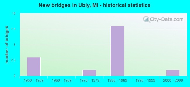
- New bridges - historical statistics
- 31950-1959
- 11970-1979
- 81980-1989
- 12000-2009


- Bridge Condition - Deck
- 40.0%Good
- 40.0%Satisfactory
- 20.0%Fair

- Bridge Condition - Superstructure
- 20.0%Good
- 40.0%Satisfactory
- 40.0%Fair

- Bridge Condition - Substructure
- 40.0%Good
- 20.0%Satisfactory
- 40.0%Fair

- Bridge Condition - Channel
- 23.1%Very good
- 23.1%Good
- 15.4%Satisfactory
- 23.1%Fair
- 7.7%Poor
- 7.7%Serious

- Bridge Condition - Culverts
- 75.0%Satisfactory
- 25.0%Fair
Find on map >> Show street view
Structure Number: 3478, Location: 1.4 MI N OF SANILAC COL (Lat: 43.701286, Lng: -82.938558), Route carried "on" structure: State highway 19, Year Built: 1957, Status: Open, Structure Length: 1.22m (4.00ft), Average Daily Traffic: 3,478 (year 2007), Truck Traffic: 10%, Average Future Daily Traffic: 2,052 (year 2018), Design Load: HS 20, Features Intersected: CASS RIVER
Minimum Vertical Clearance: 30.48m (100.00ft), Kilometerpoint: 2.256, Lanes on structure: 2, Base Highway Network: Yes (Inventory Route: 103, Subroute: 1), Owner: State Highway Agency, Approaching Roadway Width: 12.5m (41.0ft), Material/Design: Prestressed concrete, Design/Construction: Box Beam or Girders - Multiple, Number Of Spans In Main Unit: 1, Length of Maximum Span: 12.2m (40.0ft), Curb or Sidewalk Widths: Left: 0.4m (1.3ft), Right: 0.4m (1.3ft), Curb-To-Curb Width: 11.6m (38.1ft), Out-to-Out Width: 13.2m (43.3ft)
Condition: Deck: Satisfactory, Superstructure: Fair, Substructure: Fair, Channel: Good, Operating Rating: 69.3 metric tons, Method Used To Determine Operating Rating: Load Factor (LF) rating reported by rating factor (RF) method using MS18 loading, Inventory Rating: 41.5 metric tons, Method Used To Determine Inventory Rating: Load Factor (LF) rating reported by rating factor (RF) method using MS18 loading, Structural Evaluation: Somewhat better than minimum adequacy, Deck Geometry: Somewhat better than minimum adequacy, Waterway Adequacy: Equal to present desirable criteria, Approach Roadway Alignment: Equal to present desirable criteria, Length Of Structure Improvement: 1.22m (4.00ft), Designated Inspection Frequency: Every 24 months, Inspection Date: May 2020, Bridge Improvement Cost: $21,000, Roadway Improvement Cost: $2,000, Total Project Cost: $24,000, Deck Structure Type: Concrete Cast-file-Place, Wearing Surface/Protective System: Wearing Surface: Bituminous
Find on map >> Show street view
Structure Number: 3557, Location: SEC. 28-33 BINGHAM TWP. (Lat: 43.695097, Lng: -82.950392), Route carried "on" structure: ServiceCounty highway , Year Built: 1987, Status: Open, Structure Length: 0.78m (2.56ft), Average Daily Traffic: 40 (year 2009), Average Future Daily Traffic: 75 (year 2029), Design Load: HS 20, Features Intersected: SPARLING DRAIN EXTENSION, Facility Carried by Structure: MORRISON ROAD
Minimum Vertical Clearance: 30.48m (100.00ft), Kilometerpoint: 19.165, Lanes on structure: 2, Owner: County Highway Agency, Approaching Roadway Width: 9.1m (29.9ft), Material/Design: Concrete, Design/Construction: Culvert, Number Of Spans In Main Unit: 1, Length of Maximum Span: 7.3m (24.0ft), Curb-To-Curb Width: 9.8m (32.2ft), Out-to-Out Width: 11.0m (36.1ft)
Condition: Channel: Satisfactory, Culverts: Satisfactory, Operating Rating: 38.1 metric tons, Method Used To Determine Operating Rating: Field evaluation and documented engineering judgment, Inventory Rating: 32.7 metric tons, Method Used To Determine Inventory Rating: Field evaluation and documented engineering judgment, Structural Evaluation: Equal to present minimum criteria, Deck Geometry: Equal to present desirable criteria, Waterway Adequacy: Equal to present desirable criteria, Approach Roadway Alignment: Equal to present desirable criteria, Designated Inspection Frequency: Every 24 months, Inspection Date: September 2021
Find on map >> Show street view
Structure Number: 3558, Location: SEC 32-33 BINGHAM TWP (Lat: 43.687453, Lng: -82.958631), Route carried "on" structure: ServiceCounty highway , Year Built: 1987, Status: Open, Structure Length: 0.78m (2.56ft), Average Daily Traffic: 40 (year 2009), Average Future Daily Traffic: 75 (year 2029), Design Load: HS 20, Features Intersected: SPARLING DRAIN EXTENSION, Facility Carried by Structure: STAMBAUGH ROAD
Minimum Vertical Clearance: 30.48m (100.00ft), Kilometerpoint: 0.785, Lanes on structure: 2, Owner: County Highway Agency, Approaching Roadway Width: 7.3m (24.0ft), Skew: 4 degrees, Material/Design: Concrete, Design/Construction: Culvert, Number Of Spans In Main Unit: 1, Length of Maximum Span: 7.3m (24.0ft), Curb-To-Curb Width: 11.0m (36.1ft), Out-to-Out Width: 12.2m (40.0ft)
Condition: Channel: Very good, Culverts: Fair, Operating Rating: 38.1 metric tons, Method Used To Determine Operating Rating: Field evaluation and documented engineering judgment, Inventory Rating: 32.7 metric tons, Method Used To Determine Inventory Rating: Field evaluation and documented engineering judgment, Structural Evaluation: Somewhat better than minimum adequacy, Deck Geometry: Superior to present desirable criteria, Waterway Adequacy: Equal to present desirable criteria, Approach Roadway Alignment: Equal to present minimum criteria, Designated Inspection Frequency: Every 24 months, Inspection Date: September 2021, Wearing Surface/Protective System: Wearing Surface: Gravel
Find on map >> Show street view
Structure Number: 3683, Location: 0.1 MILE EAST OF M-19 (Lat: 43.708922, Lng: -82.936792), Route carried "on" structure: City street , Year Built: 2003, Status: Open, Structure Length: 1.04m (3.41ft), Average Daily Traffic: 345 (year 2010), Truck Traffic: 12%, Average Future Daily Traffic: 620 (year 2030), Design Load: HS 20, Features Intersected: NORTH BRANCH CASS RIVER, Facility Carried by Structure: UNION STREET
Minimum Vertical Clearance: 30.48m (100.00ft), Kilometerpoint: 0.573, Lanes on structure: 2, Owner: City or Municipal Highway Agency, Approaching Roadway Width: 14.6m (47.9ft), Material/Design: Prestressed concrete, Design/Construction: Box Beam or Girders - Multiple, Number Of Spans In Main Unit: 1, Length of Maximum Span: 9.8m (32.2ft), Curb or Sidewalk Widths: Left: 2.2m (7.2ft), Right: 1.5m (4.9ft), Curb-To-Curb Width: 11.6m (38.1ft), Out-to-Out Width: 16.3m (53.5ft)
Condition: Deck: Good, Superstructure: Good, Substructure: Good, Channel: Very good, Operating Rating: 86.5 metric tons, Method Used To Determine Operating Rating: Load Factor (LF) rating reported by rating factor (RF) method using MS18 loading, Inventory Rating: 51.8 metric tons, Method Used To Determine Inventory Rating: Load Factor (LF) rating reported by rating factor (RF) method using MS18 loading, Structural Evaluation: Better than present minimum criteria, Deck Geometry: Superior to present desirable criteria, Waterway Adequacy: Equal to present desirable criteria, Approach Roadway Alignment: Equal to present desirable criteria, Designated Inspection Frequency: Every 24 months, Inspection Date: July 2020, Deck Structure Type: Other, Wearing Surface/Protective System: Wearing Surface: Bituminous, Membrane: Preformed Fabric
Find on map >> Show street view
Structure Number: 3684, Location: 0.1 MILE EAST OF M-19 (Lat: 43.710008, Lng: -82.936772), Route carried "on" structure: City street , Year Built: 1980, Status: Open, Structure Length: 1.02m (3.35ft), Average Daily Traffic: 1,589 (year 2010), Average Future Daily Traffic: 2,870 (year 2030), Design Load: HS 20+Mod, Features Intersected: NORTH BRANCH CASS RIVER, Facility Carried by Structure: ATWATER ROAD
Minimum Vertical Clearance: 30.48m (100.00ft), Kilometerpoint: 43.164, Lanes on structure: 2, Owner: City or Municipal Highway Agency, Approaching Roadway Width: 13.1m (43.0ft), Material/Design: Concrete, Design/Construction: Culvert, Number Of Spans In Main Unit: 2, Length of Maximum Span: 4.9m (16.1ft), Curb or Sidewalk Widths: Left: 3.4m (11.2ft), Right: 3.7m (12.1ft), Curb-To-Curb Width: 13.1m (43.0ft), Out-to-Out Width: 21.9m (71.9ft)
Condition: Channel: Very good, Culverts: Fair, Operating Rating: 32.7 metric tons, Method Used To Determine Operating Rating: Field evaluation and documented engineering judgment, Inventory Rating: 32.7 metric tons, Method Used To Determine Inventory Rating: Field evaluation and documented engineering judgment, Structural Evaluation: Somewhat better than minimum adequacy, Deck Geometry: Better than present minimum criteria, Waterway Adequacy: Equal to present desirable criteria, Approach Roadway Alignment: Equal to present desirable criteria, Designated Inspection Frequency: Every 24 months, Inspection Date: July 2020, Deck Structure Type: Concrete Cast-file-Place, Wearing Surface/Protective System: Wearing Surface: Bituminous
Find on map >> Show street view
Structure Number: 5452, Location: SEC. 24-25 N. BRANCH TWP. (Lat: 43.180631, Lng: -83.121650), Route carried "on" structure: County highway , Year Built: 1982, Status: Open, Structure Length: 0.73m (2.40ft), Average Daily Traffic: 77 (year 2020), Average Future Daily Traffic: 94 (year 2040), Design Load: HS 20, Features Intersected: CEDAR CREEK, Facility Carried by Structure: HASSLICK ROAD
Minimum Vertical Clearance: 30.48m (100.00ft), Kilometerpoint: 4.279, Lanes on structure: 2, Owner: County Highway Agency, Approaching Roadway Width: 36.0m (118.1ft), Material/Design: Prestressed concrete, Design/Construction: Tee Beam, Number Of Spans In Main Unit: 1, Length of Maximum Span: 7.0m (23.0ft), Curb-To-Curb Width: 7.9m (25.9ft), Out-to-Out Width: 8.6m (28.2ft)
Condition: Deck: Satisfactory, Superstructure: Satisfactory, Substructure: Satisfactory, Channel: Fair, Operating Rating: 66.1 metric tons, Method Used To Determine Operating Rating: Load Factor (LF) rating reported by rating factor (RF) method using MS18 loading, Inventory Rating: 39.9 metric tons, Method Used To Determine Inventory Rating: Load Factor (LF) rating reported by rating factor (RF) method using MS18 loading, Structural Evaluation: Equal to present minimum criteria, Deck Geometry: Equal to present minimum criteria, Waterway Adequacy: Better than present minimum criteria, Approach Roadway Alignment: Equal to present minimum criteria, Designated Inspection Frequency: Every 24 months, Inspection Date: July 2021, Deck Structure Type: Concrete Precast Panels, Wearing Surface/Protective System: Wearing Surface: Monolithic Concrete, Deck Protection: Epoxy Coated Reinforcing
Find on map >> Show street view
Structure Number: 9473, Location: 2.2 MI S OF HURON CO LINE (Lat: 43.648700, Lng: -82.937806), Route carried "on" structure: State highway 19, Year Built: 1957, Year Reconstructed: 2016, Status: Open, Structure Length: 1.22m (4.00ft), Average Daily Traffic: 1,600 (year 2013), Truck Traffic: 9%, Average Future Daily Traffic: 1,840 (year 2033), Design Load: HS 20, Features Intersected: S FORK CASS RIVER
Minimum Vertical Clearance: 30.48m (100.00ft), Kilometerpoint: 25.546, Lanes on structure: 2, Base Highway Network: Yes (Inventory Route: 101, Subroute: 6), Owner: State Highway Agency, Approaching Roadway Width: 11.9m (39.0ft), Material/Design: Prestressed concrete, Design/Construction: Box Beam or Girders - Multiple, Number Of Spans In Main Unit: 1, Length of Maximum Span: 12.2m (40.0ft), Curb-To-Curb Width: 11.9m (39.0ft), Out-to-Out Width: 13.0m (42.7ft)
Condition: Deck: Good, Superstructure: Fair, Substructure: Good, Channel: Satisfactory, Operating Rating: 75.8 metric tons, Method Used To Determine Operating Rating: Load Factor (LF) rating reported by rating factor (RF) method using MS18 loading, Inventory Rating: 45.4 metric tons, Method Used To Determine Inventory Rating: Load Factor (LF) rating reported by rating factor (RF) method using MS18 loading, Structural Evaluation: Somewhat better than minimum adequacy, Deck Geometry: Equal to present minimum criteria, Waterway Adequacy: Equal to present desirable criteria, Approach Roadway Alignment: Equal to present minimum criteria, Designated Inspection Frequency: Every 24 months, Inspection Date: June 2020, Deck Structure Type: Concrete Cast-file-Place, Wearing Surface/Protective System: Wearing Surface: Monolithic Concrete, Deck Protection: Epoxy Coated Reinforcing
Find on map >> Show street view
Structure Number: 9542, Location: SEC 6-7 AUSTIN TWP (Lat: 43.664639, Lng: -82.993086), Route carried "on" structure: County highway 7498, Year Built: 1985, Status: Open, Structure Length: 1.10m (3.61ft), Average Daily Traffic: 948 (year 2002), Truck Traffic: 10%, Average Future Daily Traffic: 1,200 (year 2019), Design Load: H 20, Features Intersected: TYRE I/C DRAIN EXTN, Facility Carried by Structure: BAY CITY-FORESTVIL
Minimum Vertical Clearance: 30.48m (100.00ft), Kilometerpoint: 10.028, Lanes on structure: 2, Owner: County Highway Agency, Approaching Roadway Width: 9.8m (32.2ft), Material/Design: Steel, Design/Construction: Culvert, Number Of Spans In Main Unit: 3, Length of Maximum Span: 2.8m (9.2ft)
Condition: Channel: Fair, Culverts: Satisfactory, Operating Rating: 93.3 metric tons, Method Used To Determine Operating Rating: Load Factor (LF) rating reported by rating factor (RF) method using MS18 loading, Inventory Rating: 90.1 metric tons, Method Used To Determine Inventory Rating: Load Factor (LF) rating reported by rating factor (RF) method using MS18 loading, Structural Evaluation: Equal to present minimum criteria, Waterway Adequacy: Equal to present desirable criteria, Approach Roadway Alignment: Equal to present minimum criteria, Designated Inspection Frequency: Every 24 months, Inspection Date: June 2020, Wearing Surface/Protective System: Wearing Surface: Bituminous
Find on map >> Show street view
Structure Number: 9569, Location: SEC 7 AUSTIN TWP (Lat: 43.664106, Lng: -82.997728), Route carried "on" structure: County highway , Year Built: 1988, Status: Open, Structure Length: 1.13m (3.71ft), Average Daily Traffic: 150 (year 2010), Truck Traffic: 7%, Average Future Daily Traffic: 270 (year 2030), Design Load: H 20, Features Intersected: TYRE I/C DRAIN EXTN, Facility Carried by Structure: BAD AXE ROAD
Minimum Vertical Clearance: 30.48m (100.00ft), Kilometerpoint: 4.817, Lanes on structure: 2, Owner: County Highway Agency, Approaching Roadway Width: 7.9m (25.9ft), Material/Design: Steel, Design/Construction: Culvert, Number Of Spans In Main Unit: 3, Length of Maximum Span: 2.8m (9.2ft)
Condition: Channel: Good, Culverts: Satisfactory, Operating Rating: 18.8 metric tons, Method Used To Determine Operating Rating: Load Factor (LF) rating reported by rating factor (RF) method using MS18 loading, Inventory Rating: 11.3 metric tons, Method Used To Determine Inventory Rating: Load Factor (LF) rating reported by rating factor (RF) method using MS18 loading, Structural Evaluation: Meets minimum limits, Waterway Adequacy: Better than present minimum criteria, Approach Roadway Alignment: Equal to present minimum criteria, Designated Inspection Frequency: Every 24 months, Inspection Date: June 2020
Find on map >> Show street view
Structure Number: 957, Location: SEC 17-18 AUSTIN TWP (Lat: 43.648347, Lng: -82.977631), Route carried "on" structure: County highway , Year Built: 1950, Status: Posted for load, Structure Length: 1.01m (3.31ft), Average Daily Traffic: 300 (year 2010), Truck Traffic: 10%, Average Future Daily Traffic: 540 (year 2030), Design Load: H 15, Features Intersected: S FORK OF N BR CASS RIV, Facility Carried by Structure: WHEELER ROAD
Minimum Vertical Clearance: 30.48m (100.00ft), Kilometerpoint: 25.651, Lanes on structure: 2, Owner: County Highway Agency, Approaching Roadway Width: 7.9m (25.9ft), Material/Design: Steel, Design/Construction: Stringer/Multi-beam, Number Of Spans In Main Unit: 1, Length of Maximum Span: 9.1m (29.9ft), Curb-To-Curb Width: 5.8m (19.0ft), Out-to-Out Width: 6.7m (22.0ft)
Condition: Deck: Fair, Superstructure: Satisfactory, Substructure: Fair, Channel: Good, Operating Rating: 41.1 metric tons, Method Used To Determine Operating Rating: Load Factor (LF) rating reported by rating factor (RF) method using MS18 loading, Inventory Rating: 24.6 metric tons, Method Used To Determine Inventory Rating: Load Factor (LF) rating reported by rating factor (RF) method using MS18 loading, Structural Evaluation: Somewhat better than minimum adequacy, Deck Geometry: High priority of corrective action, Waterway Adequacy: Better than present minimum criteria, Approach Roadway Alignment: Equal to present minimum criteria, Bridge Posting: Required (Relationship of Operating Rating to Maximum Legal Load: 20.0 - 29.9% below), Designated Inspection Frequency: Every 24 months, Inspection Date: June 2020, Deck Structure Type: Concrete Cast-file-Place, Wearing Surface/Protective System: Wearing Surface: Monolithic Concrete
Find on map >> Show street view
Structure Number: 9571, Location: SEC 16-17 AUSTIN TWP (Lat: 43.647014, Lng: -82.957633), Route carried "on" structure: County highway , Year Built: 1985, Status: Open, Structure Length: 1.19m (3.90ft), Average Daily Traffic: 150 (year 2010), Truck Traffic: 7%, Average Future Daily Traffic: 270 (year 2030), Design Load: H 20, Features Intersected: S FORK OF N BR CASS RIV, Facility Carried by Structure: PATTERSON ROAD
Minimum Vertical Clearance: 30.48m (100.00ft), Kilometerpoint: 10.883, Lanes on structure: 2, Owner: County Highway Agency, Approaching Roadway Width: 7.9m (25.9ft), Material/Design: Steel, Design/Construction: Culvert, Number Of Spans In Main Unit: 3, Length of Maximum Span: 3.6m (11.8ft)
Condition: Channel: Poor, Culverts: Satisfactory, Operating Rating: 24.9 metric tons, Method Used To Determine Operating Rating: Load Factor (LF) rating reported by rating factor (RF) method using MS18 loading, Inventory Rating: 14.9 metric tons, Method Used To Determine Inventory Rating: Load Factor (LF) rating reported by rating factor (RF) method using MS18 loading, Structural Evaluation: Meets minimum limits, Waterway Adequacy: Equal to present desirable criteria, Approach Roadway Alignment: Equal to present desirable criteria, Designated Inspection Frequency: Every 24 months, Inspection Date: June 2020
Find on map >> Show street view
Structure Number: 9572, Location: SEC 10-11 AUSTIN TWP (Lat: 43.653053, Lng: -82.917831), Route carried "on" structure: County highway , Year Built: 1985, Status: Open, Structure Length: 0.69m (2.26ft), Average Daily Traffic: 160 (year 2010), Truck Traffic: 10%, Average Future Daily Traffic: 290 (year 2030), Design Load: H 20, Features Intersected: S FORK OF N BR CASS RIV, Facility Carried by Structure: FREIBERGER ROAD
Minimum Vertical Clearance: 30.48m (100.00ft), Kilometerpoint: 25.971, Lanes on structure: 2, Owner: County Highway Agency, Approaching Roadway Width: 6.7m (22.0ft), Material/Design: Steel, Design/Construction: Culvert, Number Of Spans In Main Unit: 2, Length of Maximum Span: 2.8m (9.2ft)
Condition: Channel: Serious, Culverts: Satisfactory, Operating Rating: 95.6 metric tons, Method Used To Determine Operating Rating: Load Factor (LF) rating reported by rating factor (RF) method using MS18 loading, Inventory Rating: 92.3 metric tons, Method Used To Determine Inventory Rating: Load Factor (LF) rating reported by rating factor (RF) method using MS18 loading, Structural Evaluation: Equal to present minimum criteria, Waterway Adequacy: Equal to present minimum criteria, Approach Roadway Alignment: Equal to present desirable criteria, Designated Inspection Frequency: Every 24 months, Inspection Date: June 2020
Find on map >> Show street view
Structure Number: 13256, Location: AUSTIN TWP SEC 5 & 6 (Lat: 43.679808, Lng: -82.978117), Route carried "on" structure: County highway , Year Built: 1974, Status: Open, Structure Length: 0.64m (2.10ft), Average Daily Traffic: 40 (year 1996), Truck Traffic: 5%, Average Future Daily Traffic: 55 (year 2016), Design Load: H 20, Features Intersected: TYRE I/C DRAIN EXT, Facility Carried by Structure: HURON LINE ROAD
Minimum Vertical Clearance: 30.48m (100.00ft), Kilometerpoint: 11.277, Lanes on structure: 2, Owner: County Highway Agency, Approaching Roadway Width: 6.1m (20.0ft), Skew: 3 degrees, Material/Design: Steel, Design/Construction: Culvert, Number Of Spans In Main Unit: 2, Length of Maximum Span: 3.0m (9.8ft)
Condition: Channel: Fair, Culverts: Satisfactory, Operating Rating: 46.7 metric tons, Method Used To Determine Operating Rating: Load Factor (LF) rating reported by rating factor (RF) method using MS18 loading, Inventory Rating: 39.9 metric tons, Method Used To Determine Inventory Rating: Load Factor (LF) rating reported by rating factor (RF) method using MS18 loading, Structural Evaluation: Equal to present minimum criteria, Waterway Adequacy: Better than present minimum criteria, Approach Roadway Alignment: Better than present minimum criteria, Designated Inspection Frequency: Every 24 months, Inspection Date: June 2020