Bridge Statistics for Tyler Run-Queens Gate, Pennsylvania (PA)
Condition, Traffic, Stress, Structural Evaluation, Project Costs
- National Bridge Inventory (NBI) Statistics
- 12Number of bridges
- 95ft / 28.5mTotal length
- $3,937,000Total costs
- 207,417Total average daily traffic
- 25,809Total average daily truck traffic
- National Bridge Inventory (NBI) Registered Bridges for Tyler Run-Queens Gate
- No street view available for this location
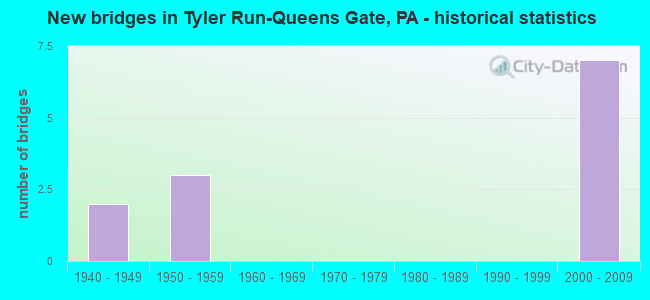
- New bridges - historical statistics
- 21940-1949
- 31950-1959
- 72000-2009


- Bridge Condition - Deck
- 33.3%Very good
- 33.3%Good
- 33.3%Satisfactory

- Bridge Condition - Superstructure
- 33.3%Very good
- 33.3%Good
- 33.3%Fair

- Bridge Condition - Substructure
- 66.7%Good
- 33.3%Fair

- Bridge Condition - Channel
- 50.0%Fair
- 50.0%Poor

- Bridge Condition - Culverts
- 50.0%Satisfactory
- 50.0%Fair
Find on map >> Show street view
Structure Number: 37388, Location: PA 74 OVER I-83 (Lat: 39.932739, Lng: -76.689525), Route carried "on" structure: State highway 74, Year Built: 1959, Status: Open, Structure Length: 5.27m (17.29ft), Average Daily Traffic: 12,458 (year 2021), Truck Traffic: 3%, Average Future Daily Traffic: 22,914 (year 2032), Design Load: HS 20, Features Intersected: SR 0083
Minimum Vertical Clearance: 30+ m (98+ ft), Kilometerpoint: 45.060, Lanes on structure: 4, Lanes under structure: 8, Base Highway Network: Yes, Owner: State Highway Agency, Approaching Roadway Width: 27.4m (89.9ft), Skew: 20 degrees, Material/Design: Steel continuous, Design/Construction: Stringer/Multi-beam, Number Of Spans In Main Unit: 3, Length of Maximum Span: 26.8m (87.9ft), Curb or Sidewalk Widths: Left: 1.5m (4.9ft), Right: 1.5m (4.9ft), Curb-To-Curb Width: 23.9m (78.4ft), Out-to-Out Width: 27.7m (90.9ft)
Condition: Deck: Satisfactory, Superstructure: Fair, Substructure: Fair, Operating Rating: 55.3 metric tons, Method Used To Determine Operating Rating: Load Factor (LF), Inventory Rating: 33.6 metric tons, Method Used To Determine Inventory Rating: Load Factor (LF), Structural Evaluation: Somewhat better than minimum adequacy, Deck Geometry: Superior to present desirable criteria, Underclear: High priority of corrective action, Approach Roadway Alignment: Equal to present desirable criteria, Length Of Structure Improvement: 6.30m (20.67ft), Designated Inspection Frequency: Every 24 months, Inspection Date: November 2019, Bridge Improvement Cost: $292,000, Roadway Improvement Cost: $859,000, Total Project Cost: $3,937,000, Deck Structure Type: Concrete Cast-file-Place, Wearing Surface/Protective System: Wearing Surface: Latex Concrete
Find on map >> Show street view
Structure Number: 38046, Location: 2 S YORK CITY/TYLER RUN (Lat: 39.924311, Lng: -76.700592), Route carried "on" structure: City street , Year Built: 1949, Status: Open, Structure Length: 0.79m (2.59ft), Average Daily Traffic: 4,610 (year 1995), Truck Traffic: 5%, Average Future Daily Traffic: 11,288 (year 2032), Features Intersected: TYLER RUN, Facility Carried by Structure: POWDER MILL ROAD
Minimum Vertical Clearance: 30+ m (98+ ft), Kilometerpoint: 0.000, Lanes on structure: 2, Owner: Town or Township Highway Agency, Approaching Roadway Width: 6.4m (21.0ft), Skew: 4 degrees, Material/Design: Concrete, Design/Construction: Culvert, Number Of Spans In Main Unit: 1, Length of Maximum Span: 7.9m (25.9ft), Curb-To-Curb Width: 8.0m (26.2ft), Out-to-Out Width: 9.0m (29.5ft)
Condition: Channel: Poor, Culverts: Fair, Operating Rating: 49.0 metric tons, Method Used To Determine Operating Rating: Field evaluation and documented engineering judgment, Inventory Rating: 32.7 metric tons, Method Used To Determine Inventory Rating: Field evaluation and documented engineering judgment, Structural Evaluation: Somewhat better than minimum adequacy, Deck Geometry: High priority of corrective action, Waterway Adequacy: Equal to present minimum criteria, Approach Roadway Alignment: Equal to present desirable criteria, Length Of Structure Improvement: 0.90m (2.95ft), Designated Inspection Frequency: Every 24 months, Inspection Date: May 2021, Deck Structure Type: Concrete Cast-file-Place, Wearing Surface/Protective System: Wearing Surface: Bituminous
Find on map >> Show street view
Structure Number: 38047, Location: 2 S YRK CITY/TYLER RUN (Lat: 39.928769, Lng: -76.704894), Route carried "on" structure: City street , Year Built: 1948, Status: Open, Structure Length: 0.79m (2.59ft), Average Daily Traffic: 4,610 (year 1995), Truck Traffic: 5%, Average Future Daily Traffic: 11,288 (year 2032), Features Intersected: TYLER RUN, Facility Carried by Structure: POWDER MILL ROAD
Minimum Vertical Clearance: 30+ m (98+ ft), Kilometerpoint: 0.000, Lanes on structure: 2, Owner: Town or Township Highway Agency, Approaching Roadway Width: 7.9m (25.9ft), Skew: 4 degrees, Material/Design: Concrete, Design/Construction: Culvert, Number Of Spans In Main Unit: 1, Length of Maximum Span: 7.9m (25.9ft), Curb-To-Curb Width: 8.0m (26.2ft), Out-to-Out Width: 9.0m (29.5ft)
Condition: Channel: Fair, Culverts: Satisfactory, Operating Rating: 49.0 metric tons, Method Used To Determine Operating Rating: Field evaluation and documented engineering judgment, Inventory Rating: 32.7 metric tons, Method Used To Determine Inventory Rating: Field evaluation and documented engineering judgment, Structural Evaluation: Equal to present minimum criteria, Deck Geometry: High priority of corrective action, Waterway Adequacy: Equal to present minimum criteria, Approach Roadway Alignment: Equal to present desirable criteria, Length Of Structure Improvement: 0.90m (2.95ft), Designated Inspection Frequency: Every 24 months, Inspection Date: May 2021, Deck Structure Type: Concrete Cast-file-Place, Wearing Surface/Protective System: Wearing Surface: Bituminous
Find on map >> Show street view
Structure Number: 43587, Location: SOUTH SIDE YORK CITY (Lat: 39.921667, Lng: -76.699181), Route carried "on" structure: State highway , Year Built: 2006, Status: Open, Structure Length: 4.27m (14.01ft), Average Daily Traffic: 4,414 (year 2022), Truck Traffic: 2%, Average Future Daily Traffic: 5,342 (year 2032), Design Load: HS 25 or greater, Features Intersected: I-83; SR 0083, Facility Carried by Structure: POWDER MILL RD
Minimum Vertical Clearance: 30+ m (98+ ft), Kilometerpoint: 0.000, Lanes on structure: 2, Lanes under structure: 6, Owner: State Highway Agency, Approaching Roadway Width: 14.0m (45.9ft), Skew: 1 degrees, Material/Design: Steel, Design/Construction: Stringer/Multi-beam, Number Of Spans In Main Unit: 1, Length of Maximum Span: 41.1m (134.8ft), Curb or Sidewalk Widths: Left: 0.2m (0.7ft), Right: 0.2m (0.7ft), Curb-To-Curb Width: 14.0m (45.9ft), Out-to-Out Width: 18.1m (59.4ft)
Condition: Deck: Very good, Superstructure: Very good, Substructure: Good, Operating Rating: 99.8 metric tons, Method Used To Determine Operating Rating: Load Factor (LF), Inventory Rating: 59.9 metric tons, Method Used To Determine Inventory Rating: Load Factor (LF), Structural Evaluation: Better than present minimum criteria, Deck Geometry: Superior to present desirable criteria, Underclear: Superior to present desirable criteria, Approach Roadway Alignment: Equal to present desirable criteria, Designated Inspection Frequency: Every 48 months, Inspection Date: June 2019, Deck Structure Type: Concrete Cast-file-Place, Wearing Surface/Protective System: Wearing Surface: Monolithic Concrete, Deck Protection: Epoxy Coated Reinforcing
Find on map >> Show street view
Structure Number: 43588, Location: 0.5 MI. N. OF SR 182 (Lat: 39.920389, Lng: -76.705289), Route carried "on" structure: Ramp State highway , Year Built: 2006, Status: Open, Structure Length: 17.40m (57.09ft), Average Daily Traffic: 2,703 (year 2021), Truck Traffic: 7%, Average Future Daily Traffic: 4,604 (year 2032), Design Load: HS 25 or greater, Features Intersected: I-83-RAMP F BUS. I83 SB, Facility Carried by Structure: RAMP F I-83;SR0083
Minimum Vertical Clearance: 30.45m (99.90ft), Kilometerpoint: 0.000, Lanes on structure: 1, Lanes under structure: 5, Base Highway Network: Yes, Owner: State Highway Agency, Approaching Roadway Width: 11.6m (38.1ft), Material/Design: Steel continuous, Design/Construction: Stringer/Multi-beam, Number Of Spans In Main Unit: 3, Length of Maximum Span: 68.9m (226.0ft), Curb or Sidewalk Widths: Left: 0.2m (0.7ft), Right: 0.2m (0.7ft), Curb-To-Curb Width: 11.6m (38.1ft), Out-to-Out Width: 12.6m (41.3ft)
Condition: Deck: Good, Superstructure: Good, Substructure: Good, Operating Rating: 69.9 metric tons, Method Used To Determine Operating Rating: Load Factor (LF), Inventory Rating: 41.7 metric tons, Method Used To Determine Inventory Rating: Load Factor (LF), Structural Evaluation: Better than present minimum criteria, Deck Geometry: Superior to present desirable criteria, Underclear: Superior to present desirable criteria, Approach Roadway Alignment: Equal to present minimum criteria, Designated Inspection Frequency: Every 48 months, Inspection Date: May 2021, Deck Structure Type: Concrete Cast-file-Place, Wearing Surface/Protective System: Wearing Surface: Monolithic Concrete, Deck Protection: Epoxy Coated Reinforcing
Find on map >> Show street view
Structure Number: 37388, Location: PA 74 OVER I-83 (Lat: 39.932739, Lng: -76.689525), Route carried "under" structure: Interstate 83, Year Built: 1959, Structure Length: 0. m, Average Daily Traffic: 33,995 (year 2022), Truck Traffic: 11%, Features Intersected: SR 0083, Facility Carried by Structure: PA 74; Queen St.
Minimum Vertical Clearance: 4.52m (14.83ft), Kilometerpoint: 24.975, Lanes on structure: 4, Lanes under structure: 4, Material/Design: Steel continuous, Design/Construction: Stringer/Multi-beam, Length of Maximum Span: 26.8m (87.9ft)
Find on map >> Show street view
Structure Number: 37388, Location: PA 74 OVER I-83 (Lat: 39.932739, Lng: -76.689525), Route carried "under" structure: Interstate 83, Year Built: 1959, Structure Length: 0. m, Average Daily Traffic: 34,592 (year 2022), Truck Traffic: 15%, Features Intersected: SR 0083, Facility Carried by Structure: PA 74; Queen St.
Minimum Vertical Clearance: 4.60m (15.09ft), Kilometerpoint: 24.940, Lanes on structure: 4, Lanes under structure: 4, Material/Design: Steel continuous, Design/Construction: Stringer/Multi-beam, Length of Maximum Span: 26.8m (87.9ft)
Find on map >> Show street view
Structure Number: 43587, Location: SOUTH SIDE YORK CITY (Lat: 39.921667, Lng: -76.699181), Route carried "under" structure: Interstate 83, Year Built: 2006, Structure Length: 0. m, Average Daily Traffic: 29,475 (year 2022), Truck Traffic: 14%, Features Intersected: I-83; SR 0083, Facility Carried by Structure: POWDER MILL RD
Minimum Vertical Clearance: 5.23m (17.16ft), Kilometerpoint: 23.326, Lanes on structure: 2, Lanes under structure: 6, Material/Design: Steel, Design/Construction: Stringer/Multi-beam, Length of Maximum Span: 41.1m (134.8ft)
Find on map >> Show street view
Structure Number: 43587, Location: SOUTH SIDE YORK CITY (Lat: 39.921667, Lng: -76.699181), Route carried "under" structure: Interstate 83, Year Built: 2006, Structure Length: 0. m, Average Daily Traffic: 24,654 (year 2022), Truck Traffic: 15%, Features Intersected: I-83; SR 0083, Facility Carried by Structure: POWDER MILL RD
Minimum Vertical Clearance: 5.23m (17.16ft), Kilometerpoint: 23.364, Lanes on structure: 2, Lanes under structure: 6, Material/Design: Steel, Design/Construction: Stringer/Multi-beam, Length of Maximum Span: 41.1m (134.8ft)
Find on map >> Show street view
Structure Number: 43588, Location: 0.5 MI. N. OF SR 182 (Lat: 39.920389, Lng: -76.705289), Route carried "under" structure: Interstate 83, Year Built: 2006, Structure Length: 0. m, Average Daily Traffic: 29,475 (year 2022), Truck Traffic: 14%, Features Intersected: I-83-RAMP F BUS. I83 SB
Minimum Vertical Clearance: 5.36m (17.59ft), Kilometerpoint: 22.523, Lanes on structure: 1, Lanes under structure: 2, Material/Design: Steel continuous, Design/Construction: Stringer/Multi-beam, Length of Maximum Span: 68.9m (226.0ft)
Find on map >> Show street view
Structure Number: 43588, Location: 0.5 MI. N. OF SR 182 (Lat: 39.920389, Lng: -76.705289), Route carried "under" structure: Interstate 83, Year Built: 2006, Structure Length: 0. m, Average Daily Traffic: 24,654 (year 2022), Truck Traffic: 15%, Features Intersected: I-83-RAMP F BUS. I83 SB
Minimum Vertical Clearance: 12.67m (41.57ft), Kilometerpoint: 22.528, Lanes on structure: 1, Lanes under structure: 2, Material/Design: Steel continuous, Design/Construction: Stringer/Multi-beam, Length of Maximum Span: 68.9m (226.0ft)
Find on map >> Show street view
Structure Number: 43588, Location: 0.5 MI. N. OF SR 182 (Lat: 39.920389, Lng: -76.705289), Route carried "under" structure: Ramp State highway , Year Built: 2006, Structure Length: 0. m, Average Daily Traffic: 1,777 (year 2021), Truck Traffic: 7%, Features Intersected: I-83-RAMP F BUS. I83 SB, Facility Carried by Structure: RAMP F I-83;SR0083
Minimum Vertical Clearance: 30+ m (98+ ft), Kilometerpoint: 0.000, Lanes on structure: 1, Lanes under structure: 1, Material/Design: Steel continuous, Design/Construction: Stringer/Multi-beam, Length of Maximum Span: 68.9m (226.0ft)