Bridge Statistics for Twisp, Washington (WA)
Condition, Traffic, Stress, Structural Evaluation, Project Costs
- National Bridge Inventory (NBI) Statistics
- 12Number of bridges
- 115ft / 35.5mTotal length
- $18,181,000Total costs
- 23,077Total average daily traffic
- 2,260Total average daily truck traffic
- 27,997Total future (year 2039) average daily traffic
- National Bridge Inventory (NBI) Registered Bridges for Twisp
- No street view available for this location
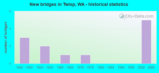
- New bridges - historical statistics
- 31940-1949
- 21950-1959
- 11960-1969
- 11970-1979
- 52000-2009


- Bridge Condition - Deck
- 10.0%Very good
- 50.0%Good
- 30.0%Satisfactory
- 10.0%Serious

- Bridge Condition - Superstructure
- 10.0%Very good
- 60.0%Good
- 10.0%Satisfactory
- 20.0%Fair

- Bridge Condition - Substructure
- 30.0%Very good
- 40.0%Good
- 20.0%Satisfactory
- 10.0%Fair

- Bridge Condition - Channel
- 75.0%Very good
- 8.3%Good
- 16.7%Satisfactory
Find on map >> Show street view
Structure Number: 3081B, Location: 37.7 E CHELAN CO (Lat: 48.382083, Lng: -120.131722), Route carried "on" structure: State highway 20, Year Built: 1945, Status: Open, Structure Length: 1.80m (5.91ft), Average Daily Traffic: 4,818 (year 2019), Truck Traffic: 9%, Average Future Daily Traffic: 5,820 (year 2039), Design Load: HS 15, Features Intersected: H W CHANNEL METHOW R
Minimum Vertical Clearance: 30+ m (98+ ft), Kilometerpoint: 322.303, Lanes on structure: 2, Base Highway Network: Yes, Owner: State Highway Agency, Approaching Roadway Width: 8.5m (27.9ft), Material/Design: Concrete continuous, Design/Construction: Slab, Number Of Spans In Main Unit: 3, Length of Maximum Span: 6.7m (22.0ft), Curb-To-Curb Width: 7.9m (25.9ft), Out-to-Out Width: 9.1m (29.9ft)
Condition: Deck: Good, Superstructure: Good, Substructure: Good, Channel: Satisfactory, Operating Rating: 24.3 metric tons, Method Used To Determine Operating Rating: Load and Resistance Factor Rating (LRFR) rating reported by rating factor(RF) method using HL-93 loadings, Inventory Rating: 18.8 metric tons, Method Used To Determine Inventory Rating: Load and Resistance Factor Rating (LRFR) rating reported by rating factor(RF) method using HL-93 loadings, Structural Evaluation: Somewhat better than minimum adequacy, Deck Geometry: High priority of corrective action, Waterway Adequacy: Equal to present minimum criteria, Approach Roadway Alignment: Equal to present desirable criteria, Length Of Structure Improvement: 1.80m (5.91ft), Designated Inspection Frequency: Every 24 months, Inspection Date: July 2021, Bridge Improvement Cost: $354,000, Roadway Improvement Cost: $71,000, Total Project Cost: $708,000 ( Estimate for 2014), Deck Structure Type: Concrete Cast-file-Place, Wearing Surface/Protective System: Wearing Surface: Bituminous
Find on map >> Show street view
Structure Number: 3081C, Location: 38.4 E CHELAN CO (Lat: 48.373083, Lng: -120.124611), Route carried "on" structure: State highway 20, Year Built: 1946, Status: Open, Structure Length: 1.80m (5.91ft), Average Daily Traffic: 4,818 (year 2019), Truck Traffic: 9%, Average Future Daily Traffic: 5,820 (year 2039), Design Load: HS 20, Features Intersected: H W CHANNEL METHOW R
Minimum Vertical Clearance: 30+ m (98+ ft), Kilometerpoint: 323.446, Lanes on structure: 2, Base Highway Network: Yes, Owner: State Highway Agency, Approaching Roadway Width: 8.2m (26.9ft), Material/Design: Concrete continuous, Design/Construction: Slab, Number Of Spans In Main Unit: 3, Length of Maximum Span: 6.7m (22.0ft), Curb-To-Curb Width: 7.9m (25.9ft), Out-to-Out Width: 9.1m (29.9ft)
Condition: Deck: Good, Superstructure: Good, Substructure: Good, Channel: Satisfactory, Operating Rating: 67.1 metric tons, Method Used To Determine Operating Rating: Load Factor (LF), Inventory Rating: 39.9 metric tons, Method Used To Determine Inventory Rating: Load Factor (LF), Structural Evaluation: Better than present minimum criteria, Deck Geometry: High priority of corrective action, Waterway Adequacy: Equal to present minimum criteria, Approach Roadway Alignment: Equal to present desirable criteria, Length Of Structure Improvement: 1.80m (5.91ft), Designated Inspection Frequency: Every 24 months, Inspection Date: July 2021, Bridge Improvement Cost: $342,000, Roadway Improvement Cost: $68,000, Total Project Cost: $684,000 ( Estimate for 2014), Deck Structure Type: Concrete Cast-file-Place, Wearing Surface/Protective System: Wearing Surface: Bituminous
Find on map >> Show street view
Structure Number: 15714A, Location: 38.8 E CHELAN CO (Lat: 48.367167, Lng: -120.122472), Route carried "on" structure: State highway 20, Year Built: 2000, Status: Open, Structure Length: 6.04m (19.82ft), Average Daily Traffic: 4,400 (year 2019), Truck Traffic: 9%, Average Future Daily Traffic: 5,315 (year 2039), Design Load: HL 93, Features Intersected: TWISP R
Minimum Vertical Clearance: 30+ m (98+ ft), Kilometerpoint: 324.138, Lanes on structure: 2, Base Highway Network: Yes, Owner: State Highway Agency, Approaching Roadway Width: 13.1m (43.0ft), Material/Design: Prestressed concrete, Design/Construction: Stringer/Multi-beam, Number Of Spans In Main Unit: 1, Length of Maximum Span: 58.2m (190.9ft), Curb or Sidewalk Widths: Left: 1.9m (6.2ft), Right: 0.0m, Curb-To-Curb Width: 10.8m (35.4ft), Out-to-Out Width: 13.8m (45.3ft)
Condition: Deck: Satisfactory, Superstructure: Good, Substructure: Very good, Channel: Very good, Operating Rating: 87.1 metric tons, Method Used To Determine Operating Rating: Load Factor (LF), Inventory Rating: 44.4 metric tons, Method Used To Determine Inventory Rating: Load Factor (LF), Structural Evaluation: Better than present minimum criteria, Deck Geometry: Somewhat better than minimum adequacy, Waterway Adequacy: Equal to present desirable criteria, Approach Roadway Alignment: Equal to present desirable criteria, Length Of Structure Improvement: 6.04m (19.82ft), Designated Inspection Frequency: Every 24 months, Inspection Date: July 2021, Bridge Improvement Cost: $1,782,000, Roadway Improvement Cost: $356,000, Total Project Cost: $3,564,000 ( Estimate for 2014), Deck Structure Type: Concrete Cast-file-Place, Wearing Surface/Protective System: Wearing Surface: Monolithic Concrete, Deck Protection: Epoxy Coated Reinforcing
Find on map >> Show street view
Structure Number: 15890A, Location: 29.3 N JCT US 97 (Lat: 48.328433, Lng: -120.061364), Route carried "on" structure: State highway 153, Year Built: 2001, Status: Open, Structure Length: 1.10m (3.61ft), Average Daily Traffic: 2,028 (year 2019), Truck Traffic: 14%, Average Future Daily Traffic: 2,449 (year 2039), Design Load: HS 25 or greater, Features Intersected: BEAVER CREEK
Minimum Vertical Clearance: 30+ m (98+ ft), Kilometerpoint: 47.089, Lanes on structure: 2, Base Highway Network: Yes, Owner: State Highway Agency, Approaching Roadway Width: 10.7m (35.1ft), Skew: 2 degrees, Material/Design: Steel, Design/Construction: Culvert, Number Of Spans In Main Unit: 1, Length of Maximum Span: 11.0m (36.1ft)
Condition: Channel: Very good, Culverts: Very good, Operating Rating: 70.3 metric tons, Method Used To Determine Operating Rating: Load and Resistance Factor Rating (LRFR) rating reported by rating factor(RF) method using HL-93 loadings, Inventory Rating: 54.1 metric tons, Method Used To Determine Inventory Rating: Load and Resistance Factor Rating (LRFR) rating reported by rating factor(RF) method using HL-93 loadings, Structural Evaluation: Equal to present desirable criteria, Waterway Adequacy: Equal to present desirable criteria, Approach Roadway Alignment: Equal to present desirable criteria, Length Of Structure Improvement: 1.10m (3.61ft), Designated Inspection Frequency: Every 48 months, Inspection Date: July 2021, Bridge Improvement Cost: $266,000, Roadway Improvement Cost: $53,000, Total Project Cost: $533,000 ( Estimate for 2014)
Find on map >> Show street view
Structure Number: 16134A, Location: 39.6 E CHELAN CO (Lat: 48.359639, Lng: -120.115583), Route carried "on" structure: State highway 20, Year Built: 2002, Status: Open, Structure Length: 11.06m (36.29ft), Average Daily Traffic: 4,589 (year 2019), Truck Traffic: 9%, Average Future Daily Traffic: 5,543 (year 2039), Design Load: HL 93, Features Intersected: METHOW RIVER
Minimum Vertical Clearance: 30+ m (98+ ft), Kilometerpoint: 325.265, Lanes on structure: 2, Base Highway Network: Yes, Owner: State Highway Agency, Approaching Roadway Width: 10.7m (35.1ft), Material/Design: Prestressed concrete continuous, Design/Construction: Stringer/Multi-beam, Number Of Spans In Main Unit: 2, Length of Maximum Span: 53.9m (176.8ft), Curb or Sidewalk Widths: Left: 0.0m, Right: 2.0m (6.6ft), Curb-To-Curb Width: 10.8m (35.4ft), Out-to-Out Width: 13.9m (45.6ft)
Condition: Deck: Good, Superstructure: Good, Substructure: Very good, Channel: Very good, Operating Rating: 89.8 metric tons, Method Used To Determine Operating Rating: Load Factor (LF), Inventory Rating: 61.7 metric tons, Method Used To Determine Inventory Rating: Load Factor (LF), Structural Evaluation: Better than present minimum criteria, Deck Geometry: Somewhat better than minimum adequacy, Waterway Adequacy: Equal to present desirable criteria, Approach Roadway Alignment: Equal to present desirable criteria, Length Of Structure Improvement: 11.06m (36.29ft), Designated Inspection Frequency: Every 24 months, Inspection Date: March 2021, Bridge Improvement Cost: $2,686,000, Roadway Improvement Cost: $537,000, Total Project Cost: $5,372,000 ( Estimate for 2014), Deck Structure Type: Concrete Cast-file-Place, Wearing Surface/Protective System: Wearing Surface: Monolithic Concrete, Deck Protection: Epoxy Coated Reinforcing
Find on map >> Show street view
Structure Number: 17131A, Location: 1.7 E JCT SR 153 (Lat: 48.347583, Lng: -120.043972), Route carried "on" structure: State highway 20, Year Built: 2006, Status: Open, Structure Length: 0.91m (2.99ft), Average Daily Traffic: 1,310 (year 2019), Truck Traffic: 15%, Average Future Daily Traffic: 1,582 (year 2039), Design Load: HS 25 or greater, Features Intersected: BEAVER CREEK
Minimum Vertical Clearance: 30+ m (98+ ft), Kilometerpoint: 331.283, Lanes on structure: 2, Base Highway Network: Yes, Owner: State Highway Agency, Approaching Roadway Width: 8.8m (28.9ft), Skew: 2 degrees, Material/Design: Concrete continuous, Design/Construction: Slab, Number Of Spans In Main Unit: 1, Length of Maximum Span: 8.5m (27.9ft), Curb-To-Curb Width: 11.0m (36.1ft), Out-to-Out Width: 18.0m (59.1ft)
Condition: Deck: Very good, Superstructure: Very good, Substructure: Very good, Channel: Good, Operating Rating: 78.0 metric tons, Method Used To Determine Operating Rating: Load Factor (LF), Inventory Rating: 47.2 metric tons, Method Used To Determine Inventory Rating: Load Factor (LF), Structural Evaluation: Equal to present desirable criteria, Deck Geometry: Equal to present minimum criteria, Waterway Adequacy: Equal to present desirable criteria, Approach Roadway Alignment: Equal to present desirable criteria, Length Of Structure Improvement: 0.91m (2.99ft), Designated Inspection Frequency: Every 48 months, Inspection Date: July 2019, Bridge Improvement Cost: $186,000, Roadway Improvement Cost: $37,000, Total Project Cost: $372,000 ( Estimate for 2014), Deck Structure Type: Concrete Precast Panels, Wearing Surface/Protective System: Wearing Surface: Bituminous
Find on map >> Show street view
Structure Number: 79893, Location: 2.8 MI.N.JCT.SR20 (Lat: 48.392361, Lng: -120.050861), Route carried "on" structure: Alternate County highway 16000, Year Built: 1957, Status: Open, Structure Length: 0.73m (2.40ft), Average Daily Traffic: 50 (year 2020), Truck Traffic: 14%, Average Future Daily Traffic: 100 (year 2041), Features Intersected: BEAVER CREEK, Facility Carried by Structure: COUNTY ROAD 1600
Minimum Vertical Clearance: 30+ m (98+ ft), Kilometerpoint: 0.001, Lanes on structure: 1, Owner: County Highway Agency, Approaching Roadway Width: 5.5m (18.0ft), Skew: 1 degrees, Material/Design: Concrete, Design/Construction: Channel Beam, Number Of Spans In Main Unit: 1, Length of Maximum Span: 7.0m (23.0ft), Curb-To-Curb Width: 4.5m (14.8ft), Out-to-Out Width: 4.9m (16.1ft)
Condition: Deck: Satisfactory, Superstructure: Fair, Substructure: Satisfactory, Channel: Very good, Operating Rating: 67.1 metric tons, Method Used To Determine Operating Rating: Load and Resistance Factor (LRFR), Inventory Rating: 39.9 metric tons, Method Used To Determine Inventory Rating: Load and Resistance Factor (LRFR), Structural Evaluation: Somewhat better than minimum adequacy, Deck Geometry: Equal to present minimum criteria, Waterway Adequacy: Equal to present desirable criteria, Approach Roadway Alignment: Equal to present minimum criteria, Length Of Structure Improvement: 1.04m (3.41ft), Designated Inspection Frequency: Every 12 months, Inspection Date: October 2021, Bridge Improvement Cost: $354,000, Roadway Improvement Cost: $71,000, Total Project Cost: $707,000 ( Estimate for 2014), Deck Structure Type: Concrete Precast Panels, Wearing Surface/Protective System: Wearing Surface: Monolithic Concrete
Find on map >> Show street view
Structure Number: 81087, Location: 4.1 W.SR20 @ TWISP (Lat: 48.373611, Lng: -120.202500), Route carried "on" structure: Alternate County highway 10750, Year Built: 1974, Status: Open, Structure Length: 2.38m (7.81ft), Average Daily Traffic: 31 (year 2018), Truck Traffic: 16%, Average Future Daily Traffic: 40 (year 2040), Design Load: HS 20, Features Intersected: TWISP RIVER, Facility Carried by Structure: COUNTY ROAD 1075
Minimum Vertical Clearance: 30+ m (98+ ft), Kilometerpoint: 0.001, Lanes on structure: 1, Owner: County Highway Agency, Approaching Roadway Width: 4.9m (16.1ft), Material/Design: Prestressed concrete, Design/Construction: Tee Beam, Number Of Spans In Main Unit: 1, Length of Maximum Span: 23.5m (77.1ft), Curb-To-Curb Width: 4.4m (14.4ft), Out-to-Out Width: 4.9m (16.1ft)
Condition: Deck: Good, Superstructure: Good, Substructure: Good, Channel: Very good, Operating Rating: 36.0 metric tons, Method Used To Determine Operating Rating: Load and Resistance Factor Rating (LRFR) rating reported by rating factor(RF) method using HL-93 loadings, Inventory Rating: 27.5 metric tons, Method Used To Determine Inventory Rating: Load and Resistance Factor Rating (LRFR) rating reported by rating factor(RF) method using HL-93 loadings, Structural Evaluation: Equal to present minimum criteria, Deck Geometry: Equal to present minimum criteria, Waterway Adequacy: Equal to present desirable criteria, Approach Roadway Alignment: Equal to present minimum criteria, Length Of Structure Improvement: 2.68m (8.79ft), Designated Inspection Frequency: Every 24 months, Inspection Date: October 2021, Bridge Improvement Cost: $915,000, Roadway Improvement Cost: $183,000, Total Project Cost: $1,830,000 ( Estimate for 2014), Deck Structure Type: Other, Wearing Surface/Protective System: Wearing Surface: Monolithic Concrete
Find on map >> Show street view
Structure Number: 81404, Location: .SESES12T33NR21E (Lat: 48.369722, Lng: -120.148056), Route carried "on" structure: County highway 91140, Year Built: 1949, Status: Open, Structure Length: 3.29m (10.79ft), Average Daily Traffic: 585 (year 2018), Truck Traffic: 8%, Average Future Daily Traffic: 800 (year 2040), Design Load: H 15, Features Intersected: TWISP RIVER, Facility Carried by Structure: FAS ROUTE A240
Minimum Vertical Clearance: 30+ m (98+ ft), Kilometerpoint: 0.001, Lanes on structure: 2, Owner: County Highway Agency, Approaching Roadway Width: 9.1m (29.9ft), Material/Design: Steel, Design/Construction: Stringer/Multi-beam, Number Of Spans In Main Unit: 1, Number Of Approach Spans: 2, Length of Maximum Span: 24.4m (80.1ft), Curb or Sidewalk Widths: Left: 0.8m (2.6ft), Right: 0.8m (2.6ft), Curb-To-Curb Width: 7.9m (25.9ft), Out-to-Out Width: 9.4m (30.8ft)
Condition: Deck: Serious, Superstructure: Fair, Substructure: Satisfactory, Channel: Very good, Operating Rating: 50.8 metric tons, Method Used To Determine Operating Rating: Load and Resistance Factor (LRFR), Inventory Rating: 30.8 metric tons, Method Used To Determine Inventory Rating: Load and Resistance Factor (LRFR), Structural Evaluation: Somewhat better than minimum adequacy, Deck Geometry: Somewhat better than minimum adequacy, Waterway Adequacy: Equal to present desirable criteria, Approach Roadway Alignment: Equal to present desirable criteria, Length Of Structure Improvement: 3.29m (10.79ft), Designated Inspection Frequency: Every 24 months, Inspection Date: October 2021, Bridge Improvement Cost: $691,000, Roadway Improvement Cost: $138,000, Total Project Cost: $1,382,000 ( Estimate for 2014), Deck Structure Type: Concrete Cast-file-Place, Wearing Surface/Protective System: Wearing Surface: Monolithic Concrete
Find on map >> Show street view
Structure Number: 81831, Location: 10.9 W.SR20 @ TWISP (Lat: 48.363889, Lng: -120.336944), Route carried "on" structure: Alternate County highway 10900, Year Built: 1959, Status: Open, Structure Length: 3.11m (10.20ft), Average Daily Traffic: 53 (year 2018), Truck Traffic: 17%, Average Future Daily Traffic: 88 (year 2040), Design Load: HS 15, Features Intersected: TWISP RIVER, Facility Carried by Structure: COUNTY ROAD 1090
Minimum Vertical Clearance: 30+ m (98+ ft), Kilometerpoint: 0.001, Lanes on structure: 1, Owner: County Highway Agency, Approaching Roadway Width: 6.1m (20.0ft), Material/Design: Concrete continuous, Design/Construction: Stringer/Multi-beam, Number Of Spans In Main Unit: 2, Length of Maximum Span: 18.0m (59.1ft), Curb or Sidewalk Widths: Left: 0.3m (1.0ft), Right: 0.3m (1.0ft), Curb-To-Curb Width: 4.3m (14.1ft), Out-to-Out Width: 4.9m (16.1ft)
Condition: Deck: Satisfactory, Superstructure: Satisfactory, Substructure: Fair, Channel: Very good, Operating Rating: 54.4 metric tons, Method Used To Determine Operating Rating: Allowable Stress (AS), Inventory Rating: 34.5 metric tons, Method Used To Determine Inventory Rating: Allowable Stress (AS), Structural Evaluation: Somewhat better than minimum adequacy, Deck Geometry: Equal to present minimum criteria, Waterway Adequacy: Equal to present desirable criteria, Approach Roadway Alignment: Equal to present desirable criteria, Length Of Structure Improvement: 3.11m (10.20ft), Designated Inspection Frequency: Every 12 months, Inspection Date: October 2021, Bridge Improvement Cost: $449,000, Roadway Improvement Cost: $90,000, Total Project Cost: $898,000 ( Estimate for 2014), Deck Structure Type: Concrete Cast-file-Place, Wearing Surface/Protective System: Wearing Surface: Monolithic Concrete
Find on map >> Show street view
Structure Number: 81847, Location: 11.1 W.SR20 @ TWISP (Lat: 48.361650, Lng: -120.337511), Route carried "on" structure: Alternate County highway 10900, Year Built: 1960, Year Reconstructed: 2007, Status: Open, Structure Length: 2.01m (6.59ft), Average Daily Traffic: 74 (year 2020), Truck Traffic: 8%, Average Future Daily Traffic: 90 (year 2040), Design Load: HS 15, Features Intersected: BUTTER MILK CREEK, Facility Carried by Structure: COUNTY ROAD 1090
Minimum Vertical Clearance: 30+ m (98+ ft), Kilometerpoint: 0.001, Lanes on structure: 1, Owner: County Highway Agency, Approaching Roadway Width: 6.1m (20.0ft), Skew: 1 degrees, Material/Design: Concrete continuous, Design/Construction: Stringer/Multi-beam, Number Of Spans In Main Unit: 3, Length of Maximum Span: 14.0m (45.9ft), Curb-To-Curb Width: 4.3m (14.1ft), Out-to-Out Width: 4.9m (16.1ft)
Condition: Deck: Good, Superstructure: Good, Substructure: Good, Channel: Very good, Operating Rating: 67.1 metric tons, Method Used To Determine Operating Rating: Allowable Stress (AS), Inventory Rating: 46.3 metric tons, Method Used To Determine Inventory Rating: Allowable Stress (AS), Structural Evaluation: Better than present minimum criteria, Deck Geometry: Equal to present minimum criteria, Waterway Adequacy: Equal to present desirable criteria, Approach Roadway Alignment: Equal to present minimum criteria, Length Of Structure Improvement: 2.01m (6.59ft), Designated Inspection Frequency: Every 24 months, Inspection Date: October 2020, Bridge Improvement Cost: $290,000, Roadway Improvement Cost: $58,000, Total Project Cost: $581,000 ( Estimate for 2014), Deck Structure Type: Concrete Cast-file-Place, Wearing Surface/Protective System: Wearing Surface: Monolithic Concrete
Find on map >> Show street view
Structure Number: 87782, Location: 8.07 Mi West of Twisp (Lat: 48.379250, Lng: -120.286083), Route carried "on" structure: County highway 91140, Year Built: 2008, Status: Open, Structure Length: 1.25m (4.10ft), Average Daily Traffic: 321 (year 2020), Truck Traffic: 11%, Average Future Daily Traffic: 350 (year 2041), Design Load: HS 25 or greater, Features Intersected: LITTLE BRIDGE CREEK, Facility Carried by Structure: TWISP RIVER ROAD
Minimum Vertical Clearance: 30+ m (98+ ft), Kilometerpoint: 0.001, Lanes on structure: 2, Owner: County Highway Agency, Approaching Roadway Width: 7.3m (24.0ft), Material/Design: Steel, Design/Construction: Culvert, Number Of Spans In Main Unit: 1, Length of Maximum Span: 12.2m (40.0ft), Curb-To-Curb Width: 8.5m (27.9ft), Out-to-Out Width: 8.5m (27.9ft)
Condition: Channel: Very good, Culverts: Very good, Operating Rating: 40.8 metric tons, Method Used To Determine Operating Rating: Field evaluation and documented engineering judgment, Inventory Rating: 32.7 metric tons, Method Used To Determine Inventory Rating: Field evaluation and documented engineering judgment, Structural Evaluation: Equal to present desirable criteria, Deck Geometry: Equal to present minimum criteria, Waterway Adequacy: Equal to present desirable criteria, Approach Roadway Alignment: Equal to present desirable criteria, Length Of Structure Improvement: 1.55m (5.09ft), Designated Inspection Frequency: Every 24 months, Inspection Date: October 2021, Bridge Improvement Cost: $775,000, Roadway Improvement Cost: $155,000, Total Project Cost: $1,550,000 ( Estimate for 2014)