Bridge Statistics for Tustin, Michigan (MI)
Condition, Traffic, Stress, Structural Evaluation, Project Costs
- National Bridge Inventory (NBI) Statistics
- 13Number of bridges
- 95ft / 29.3mTotal length
- 41,314Total average daily traffic
- 5,071Total average daily truck traffic
- National Bridge Inventory (NBI) Registered Bridges for Tustin
- No street view available for this location
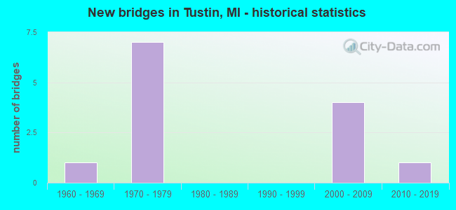
- New bridges - historical statistics
- 11960-1969
- 71970-1979
- 42000-2009
- 12010-2019


- Bridge Condition - Deck
- 25.0%Very good
- 75.0%Good

- Bridge Condition - Superstructure
- 80.0%Very good
- 20.0%Good

- Bridge Condition - Substructure
- 80.0%Very good
- 20.0%Satisfactory

- Bridge Condition - Channel
- 14.3%Very good
- 71.4%Good
- 14.3%Satisfactory

- Bridge Condition - Culverts
- 60.0%Very good
- 20.0%Good
- 20.0%Satisfactory
Find on map >> Show street view
Structure Number: 8543, Location: 0.8 MI N OF MARION RD (Lat: 44.116111, Lng: -85.470936), Route carried "on" structure: US 131, Year Built: 1965, Status: Open, Structure Length: 0.61m (2.00ft), Average Daily Traffic: 5,863 (year 2007), Truck Traffic: 13%, Average Future Daily Traffic: 8,615 (year 2018), Design Load: HS 20, Features Intersected: ROSE LAKE OUTLET
Minimum Vertical Clearance: 30.48m (100.00ft), Kilometerpoint: 34.229, Lanes on structure: 2, Base Highway Network: Yes (Inventory Route: 184, Subroute: 9), Owner: State Highway Agency, Approaching Roadway Width: 11.0m (36.1ft), Material/Design: Concrete, Design/Construction: Culvert, Number Of Spans In Main Unit: 2, Length of Maximum Span: 2.7m (8.9ft), Out-to-Out Width: 29.0m (95.1ft)
Condition: Channel: Good, Culverts: Satisfactory, Operating Rating: 97.2 metric tons, Method Used To Determine Operating Rating: Load Factor (LF) rating reported by rating factor (RF) method using MS18 loading, Inventory Rating: 97.2 metric tons, Method Used To Determine Inventory Rating: Load Factor (LF) rating reported by rating factor (RF) method using MS18 loading, Structural Evaluation: Equal to present minimum criteria, Waterway Adequacy: Equal to present minimum criteria, Approach Roadway Alignment: Equal to present minimum criteria, Designated Inspection Frequency: Every 24 months, Inspection Date: March 2022
Find on map >> Show street view
Structure Number: 8545, Location: 0.8 MI N OF MARION RD (Lat: 44.115839, Lng: -85.470133), Route carried "on" structure: US 131, Year Built: 1975, Status: Open, Structure Length: 0.61m (2.00ft), Average Daily Traffic: 5,863 (year 2007), Truck Traffic: 13%, Average Future Daily Traffic: 8,615 (year 2018), Design Load: HS 20, Features Intersected: ROSE LAKE OUTLET
Minimum Vertical Clearance: 30.48m (100.00ft), Kilometerpoint: 34.237, Lanes on structure: 2, Base Highway Network: Yes (Inventory Route: 184, Subroute: 8), Owner: State Highway Agency, Approaching Roadway Width: 11.0m (36.1ft), Material/Design: Concrete, Design/Construction: Culvert, Number Of Spans In Main Unit: 2, Length of Maximum Span: 2.7m (8.9ft)
Condition: Channel: Good, Culverts: Good, Operating Rating: 97.2 metric tons, Method Used To Determine Operating Rating: Load Factor (LF) rating reported by rating factor (RF) method using MS18 loading, Inventory Rating: 97.2 metric tons, Method Used To Determine Inventory Rating: Load Factor (LF) rating reported by rating factor (RF) method using MS18 loading, Structural Evaluation: Better than present minimum criteria, Waterway Adequacy: Equal to present minimum criteria, Approach Roadway Alignment: Equal to present minimum criteria, Designated Inspection Frequency: Every 24 months, Inspection Date: March 2022
Find on map >> Show street view
Structure Number: 8548, Location: 2.2 MI SW OF TUSTIN (Lat: 44.073758, Lng: -85.482739), Route carried "on" structure: County highway 6676, Year Built: 1975, Status: Posted for load, Structure Length: 12.31m (40.39ft), Average Daily Traffic: 350 (year 1977), Average Future Daily Traffic: 350 (year 1977), Design Load: H 20, Features Intersected: US-131, Facility Carried by Structure: 18 MILE RD(ROSE LK
Minimum Vertical Clearance: 30.48m (100.00ft), Kilometerpoint: 1.679, Lanes on structure: 2, Lanes under structure: 4, Owner: State Highway Agency, Approaching Roadway Width: 10.9m (35.8ft), Skew: 1 degrees, Material/Design: Steel, Design/Construction: Stringer/Multi-beam, Number Of Spans In Main Unit: 5, Length of Maximum Span: 33.5m (109.9ft), Curb-To-Curb Width: 10.9m (35.8ft), Out-to-Out Width: 11.7m (38.4ft)
Condition: Deck: Good, Superstructure: Very good, Substructure: Satisfactory, Operating Rating: 32.7 metric tons, Method Used To Determine Operating Rating: Load Factor (LF) rating reported by rating factor (RF) method using MS18 loading, Inventory Rating: 16.8 metric tons, Method Used To Determine Inventory Rating: Load Factor (LF) rating reported by rating factor (RF) method using MS18 loading, Structural Evaluation: Somewhat better than minimum adequacy, Deck Geometry: Better than present minimum criteria, Underclear: Somewhat better than minimum adequacy, Approach Roadway Alignment: Better than present minimum criteria, Bridge Posting: Required (Relationship of Operating Rating to Maximum Legal Load: > 39.9% below), Designated Inspection Frequency: Every 24 months, Inspection Date: September 2020, Deck Structure Type: Concrete Cast-file-Place, Wearing Surface/Protective System: Wearing Surface: Monolithic Concrete
Find on map >> Show street view
Structure Number: 8549, Location: 0.5 MI W OF TUSTIN (Lat: 44.102789, Lng: -85.473567), Route carried "on" structure: County highway 6782, Year Built: 1975, Status: Open, Structure Length: 4.63m (15.19ft), Average Daily Traffic: 1,400 (year 1996), Truck Traffic: 3%, Average Future Daily Traffic: 9,999 (year 1977), Design Load: H 20, Features Intersected: US-131 SB, Facility Carried by Structure: 20 MILE RD(MARION)
Minimum Vertical Clearance: 30.48m (100.00ft), Kilometerpoint: 7.247, Lanes on structure: 2, Lanes under structure: 2, Owner: State Highway Agency, Approaching Roadway Width: 13.4m (44.0ft), Material/Design: Steel, Design/Construction: Stringer/Multi-beam, Number Of Spans In Main Unit: 1, Length of Maximum Span: 46.3m (151.9ft), Curb-To-Curb Width: 12.8m (42.0ft), Out-to-Out Width: 13.5m (44.3ft)
Condition: Deck: Good, Superstructure: Good, Substructure: Very good, Operating Rating: 97.2 metric tons, Method Used To Determine Operating Rating: Load Factor (LF) rating reported by rating factor (RF) method using MS18 loading, Inventory Rating: 87.2 metric tons, Method Used To Determine Inventory Rating: Load Factor (LF) rating reported by rating factor (RF) method using MS18 loading, Structural Evaluation: Better than present minimum criteria, Deck Geometry: Better than present minimum criteria, Underclear: Better than present minimum criteria, Approach Roadway Alignment: Better than present minimum criteria, Designated Inspection Frequency: Every 24 months, Inspection Date: May 2020, Deck Structure Type: Concrete Cast-file-Place, Wearing Surface/Protective System: Wearing Surface: Epoxy Overlay
Find on map >> Show street view
Structure Number: 855, Location: 0.5 MI W OF TUSTIN (Lat: 44.102756, Lng: -85.472064), Route carried "on" structure: County highway 6782, Year Built: 1975, Status: Open, Structure Length: 4.63m (15.19ft), Average Daily Traffic: 1,400 (year 1996), Truck Traffic: 3%, Average Future Daily Traffic: 9,999 (year 1977), Design Load: H 20, Features Intersected: US-131 NB, Facility Carried by Structure: 20 MILE RD(MARION)
Minimum Vertical Clearance: 30.48m (100.00ft), Kilometerpoint: 7.368, Lanes on structure: 2, Lanes under structure: 2, Owner: State Highway Agency, Approaching Roadway Width: 13.4m (44.0ft), Skew: 1 degrees, Material/Design: Steel, Design/Construction: Stringer/Multi-beam, Number Of Spans In Main Unit: 1, Length of Maximum Span: 46.3m (151.9ft), Curb-To-Curb Width: 12.8m (42.0ft), Out-to-Out Width: 13.5m (44.3ft)
Condition: Deck: Good, Superstructure: Very good, Substructure: Very good, Operating Rating: 91.4 metric tons, Method Used To Determine Operating Rating: Load Factor (LF) rating reported by rating factor (RF) method using MS18 loading, Inventory Rating: 54.8 metric tons, Method Used To Determine Inventory Rating: Load Factor (LF) rating reported by rating factor (RF) method using MS18 loading, Structural Evaluation: Equal to present desirable criteria, Deck Geometry: Better than present minimum criteria, Underclear: Equal to present minimum criteria, Approach Roadway Alignment: Better than present minimum criteria, Designated Inspection Frequency: Every 24 months, Inspection Date: May 2020, Deck Structure Type: Concrete Cast-file-Place, Wearing Surface/Protective System: Wearing Surface: Monolithic Concrete
Find on map >> Show street view
Structure Number: 8611, Location: SECTION 21/28 T20N R10W (Lat: 44.103025, Lng: -85.516836), Route carried "on" structure: County highway 6782, Year Built: 2009, Status: Open, Structure Length: 1.44m (4.72ft), Average Daily Traffic: 1,521 (year 2017), Truck Traffic: 4%, Average Future Daily Traffic: 3,000 (year 2037), Design Load: HS 20+Mod, Features Intersected: E BR PINE RIVER, Facility Carried by Structure: 20 MILE ROAD
Minimum Vertical Clearance: 30+ m (98+ ft), Kilometerpoint: 3.782, Lanes on structure: 2, Owner: County Highway Agency, Approaching Roadway Width: 11.6m (38.1ft), Material/Design: Prestressed concrete, Design/Construction: Arch - Deck, Number Of Spans In Main Unit: 1, Length of Maximum Span: 12.8m (42.0ft), Curb-To-Curb Width: 11.6m (38.1ft), Out-to-Out Width: 12.6m (41.3ft)
Condition: Superstructure: Very good, Substructure: Very good, Channel: Good, Operating Rating: 36.0 metric tons, Method Used To Determine Operating Rating: Load Factor (LF), Inventory Rating: 32.4 metric tons, Method Used To Determine Inventory Rating: Load Factor (LF), Structural Evaluation: Equal to present desirable criteria, Deck Geometry: Equal to present minimum criteria, Waterway Adequacy: Equal to present desirable criteria, Approach Roadway Alignment: Equal to present desirable criteria, Designated Inspection Frequency: Every 24 months, Inspection Date: August 2020, Wearing Surface/Protective System: Wearing Surface: Bituminous
Find on map >> Show street view
Structure Number: 8614, Location: SEC 14/15 T20N R10W (Lat: 44.121067, Lng: -85.484258), Route carried "on" structure: County highway 6715, Year Built: 2013, Status: Open, Structure Length: 0.87m (2.85ft), Average Daily Traffic: 757 (year 2017), Truck Traffic: 4%, Average Future Daily Traffic: 1,500 (year 2037), Design Load: Greater than HL93, Features Intersected: ROSE LAKE OUTLET, Facility Carried by Structure: 200TH AVE
Minimum Vertical Clearance: 30+ m (98+ ft), Kilometerpoint: 5.419, Lanes on structure: 2, Owner: County Highway Agency, Approaching Roadway Width: 9.8m (32.2ft), Skew: 2 degrees, Material/Design: Concrete, Design/Construction: Culvert, Number Of Spans In Main Unit: 1, Length of Maximum Span: 8.1m (26.6ft), Curb-To-Curb Width: 9.8m (32.2ft), Out-to-Out Width: 29.3m (96.1ft)
Condition: Channel: Very good, Culverts: Very good, Operating Rating: 62.9 metric tons, Method Used To Determine Operating Rating: Load and Resistance Factor Rating (LRFR) rating reported by rating factor(RF) method using HL-93 loadings, Inventory Rating: 48.6 metric tons, Method Used To Determine Inventory Rating: Load and Resistance Factor Rating (LRFR) rating reported by rating factor(RF) method using HL-93 loadings, Structural Evaluation: Equal to present desirable criteria, Deck Geometry: Equal to present minimum criteria, Waterway Adequacy: Equal to present desirable criteria, Approach Roadway Alignment: Equal to present desirable criteria, Designated Inspection Frequency: Every 24 months, Inspection Date: July 2021, Wearing Surface/Protective System: Wearing Surface: Bituminous
Find on map >> Show street view
Structure Number: 8622, Location: SECTION 15/22 T20N R10W (Lat: 44.117694, Lng: -85.501375), Route carried "on" structure: County highway , Year Built: 2003, Status: Open, Structure Length: 0.65m (2.13ft), Average Daily Traffic: 53 (year 2017), Truck Traffic: 2%, Average Future Daily Traffic: 100 (year 2037), Design Load: HS 20+Mod, Features Intersected: EAST BRANCH PINE RIVER, Facility Carried by Structure: 21 MILE RD
Minimum Vertical Clearance: 30.48m (100.00ft), Kilometerpoint: 5.023, Lanes on structure: 2, Owner: County Highway Agency, Approaching Roadway Width: 6.7m (22.0ft), Material/Design: Aluminum, Iron, Design/Construction: Culvert, Number Of Spans In Main Unit: 1, Length of Maximum Span: 6.4m (21.0ft), Curb-To-Curb Width: 7.3m (24.0ft), Out-to-Out Width: 14.6m (47.9ft)
Condition: Channel: Good, Culverts: Very good, Operating Rating: 61.9 metric tons, Method Used To Determine Operating Rating: Load Factor (LF) rating reported by rating factor (RF) method using MS18 loading, Inventory Rating: 37.3 metric tons, Method Used To Determine Inventory Rating: Load Factor (LF) rating reported by rating factor (RF) method using MS18 loading, Structural Evaluation: Equal to present desirable criteria, Deck Geometry: Equal to present minimum criteria, Waterway Adequacy: Better than present minimum criteria, Approach Roadway Alignment: Better than present minimum criteria, Designated Inspection Frequency: Every 24 months, Inspection Date: August 2020, Wearing Surface/Protective System: Wearing Surface: Gravel
Find on map >> Show street view
Structure Number: 8623, Location: SECTION 28/29 T20N R10W (Lat: 44.100617, Lng: -85.523600), Route carried "on" structure: County highway , Year Built: 2008, Status: Open, Structure Length: 2.77m (9.09ft), Average Daily Traffic: 62 (year 2017), Truck Traffic: 4%, Average Future Daily Traffic: 120 (year 2037), Design Load: HS 20, Features Intersected: EAST BRANCH PINE RIVER, Facility Carried by Structure: 220 TH AVE
Minimum Vertical Clearance: 30.48m (100.00ft), Kilometerpoint: 1.355, Lanes on structure: 2, Owner: County Highway Agency, Approaching Roadway Width: 7.3m (24.0ft), Material/Design: Wood or Timber, Design/Construction: Stringer/Multi-beam, Number Of Spans In Main Unit: 3, Length of Maximum Span: 8.5m (27.9ft), Curb-To-Curb Width: 8.5m (27.9ft), Out-to-Out Width: 8.9m (29.2ft)
Condition: Deck: Very good, Superstructure: Very good, Substructure: Very good, Channel: Satisfactory, Operating Rating: 58.6 metric tons, Method Used To Determine Operating Rating: Allowable Stress (AS) rating reported by rating factor (RF) method using MS18 loading, Inventory Rating: 41.8 metric tons, Method Used To Determine Inventory Rating: Allowable Stress (AS) rating reported by rating factor (RF) method using MS18 loading, Structural Evaluation: Equal to present desirable criteria, Deck Geometry: Better than present minimum criteria, Waterway Adequacy: Superior to present desirable criteria, Approach Roadway Alignment: Better than present minimum criteria, Designated Inspection Frequency: Every 24 months, Inspection Date: August 2020, Deck Structure Type: Wood or Timber, Wearing Surface/Protective System: Wearing Surface: Bituminous
Find on map >> Show street view
Structure Number: 13251, Location: BURDELL TWP SEC 21/22 (Lat: 44.115919, Lng: -85.504511), Route carried "on" structure: County highway , Year Built: 2003, Status: Open, Structure Length: 0.76m (2.49ft), Average Daily Traffic: 133 (year 2017), Truck Traffic: 18%, Average Future Daily Traffic: 250 (year 2037), Design Load: HS 20, Features Intersected: PINE RIVER, Facility Carried by Structure: 210TH AVENUE
Minimum Vertical Clearance: 30.48m (100.00ft), Kilometerpoint: 5.496, Lanes on structure: 2, Owner: County Highway Agency, Approaching Roadway Width: 7.6m (24.9ft), Skew: 3 degrees, Material/Design: Aluminum, Iron, Design/Construction: Culvert, Number Of Spans In Main Unit: 1, Length of Maximum Span: 7.0m (23.0ft), Curb-To-Curb Width: 7.6m (24.9ft), Out-to-Out Width: 19.5m (64.0ft)
Condition: Channel: Good, Culverts: Very good, Operating Rating: 75.5 metric tons, Method Used To Determine Operating Rating: Load Factor (LF) rating reported by rating factor (RF) method using MS18 loading, Inventory Rating: 45.4 metric tons, Method Used To Determine Inventory Rating: Load Factor (LF) rating reported by rating factor (RF) method using MS18 loading, Structural Evaluation: Equal to present desirable criteria, Deck Geometry: Somewhat better than minimum adequacy, Waterway Adequacy: Superior to present desirable criteria, Approach Roadway Alignment: Equal to present desirable criteria, Designated Inspection Frequency: Every 24 months, Inspection Date: August 2020
Find on map >> Show street view
Structure Number: 8548, Location: 2.2 MI SW OF TUSTIN (Lat: 44.073758, Lng: -85.482739), Route carried "under" structure: US 131, Year Built: 1975, Structure Length: 0. m, Average Daily Traffic: 11,956 (year 2007), Truck Traffic: 15%, Features Intersected: US-131, Facility Carried by Structure: 18 MILE RD(ROSE LK
Minimum Vertical Clearance: 4.93m (16.17ft), Kilometerpoint: 29.442, Lanes on structure: 2, Lanes under structure: 4, Material/Design: Steel, Design/Construction: Stringer/Multi-beam, Length of Maximum Span: 33.5m (109.9ft)
Find on map >> Show street view
Structure Number: 8549, Location: 0.5 MI W OF TUSTIN (Lat: 44.102789, Lng: -85.473567), Route carried "under" structure: US 131, Year Built: 1975, Structure Length: 0. m, Average Daily Traffic: 5,978 (year 2007), Truck Traffic: 13%, Features Intersected: US-131 SB, Facility Carried by Structure: 20 MILE RD(MARION)
Minimum Vertical Clearance: 5.13m (16.83ft), Kilometerpoint: 32.732, Lanes on structure: 2, Lanes under structure: 2, Material/Design: Steel, Design/Construction: Stringer/Multi-beam, Length of Maximum Span: 46.3m (151.9ft)
Find on map >> Show street view
Structure Number: 855, Location: 0.5 MI W OF TUSTIN (Lat: 44.102756, Lng: -85.472064), Route carried "under" structure: US 131, Year Built: 1975, Structure Length: 0. m, Average Daily Traffic: 5,978 (year 2007), Truck Traffic: 13%, Features Intersected: US-131 NB, Facility Carried by Structure: 20 MILE RD(MARION)
Minimum Vertical Clearance: 5.05m (16.57ft), Kilometerpoint: 32.774, Lanes on structure: 2, Lanes under structure: 2, Material/Design: Steel, Design/Construction: Stringer/Multi-beam, Length of Maximum Span: 46.3m (151.9ft)