Bridge Statistics for Trevose, Pennsylvania (PA)
Condition, Traffic, Stress, Structural Evaluation, Project Costs
- National Bridge Inventory (NBI) Statistics
- 14Number of bridges
- 184ft / 55.8mTotal length
- $6,715,000Total costs
- 445,150Total average daily traffic
- 43,555Total average daily truck traffic
- National Bridge Inventory (NBI) Registered Bridges for Trevose
- No street view available for this location
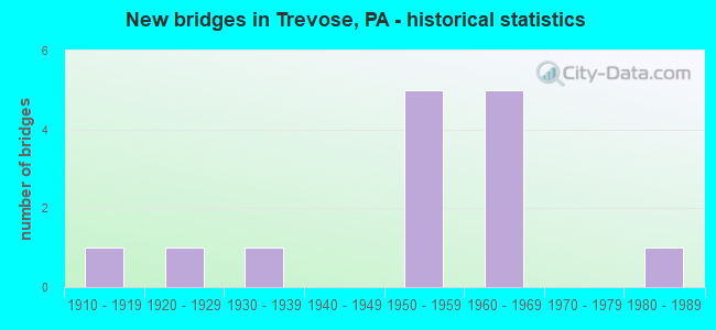
- New bridges - historical statistics
- 11910-1919
- 11920-1929
- 11930-1939
- 51950-1959
- 51960-1969
- 11980-1989

- Reconstructed bridges - Historical Statistics
- 11960-1969
- 01970-1979
- 21980-1989
- 21990-1999


- Bridge Condition - Deck
- 14.3%Good
- 28.6%Satisfactory
- 42.9%Fair
- 14.3%Serious

- Bridge Condition - Superstructure
- 22.2%Satisfactory
- 55.6%Fair
- 22.2%Poor

- Bridge Condition - Substructure
- 33.3%Satisfactory
- 55.6%Fair
- 11.1%Poor

- Bridge Condition - Channel
- 66.7%Fair
- 33.3%Poor
Find on map >> Show street view
Structure Number: 6717, Location: NESHAMINY MALL 41F04 (Lat: 40.139092, Lng: -74.960286), Route carried "on" structure: US 1, Year Built: 1965, Status: Open, Structure Length: 4.36m (14.30ft), Average Daily Traffic: 83,548 (year 2022), Truck Traffic: 7%, Average Future Daily Traffic: 94,759 (year 2032), Design Load: HS 20, Features Intersected: ROCKHILL DRIVE, Facility Carried by Structure: LINCOLN HIGHWAY
Minimum Vertical Clearance: 30+ m (98+ ft), Kilometerpoint: 2.242, Lanes on structure: 5, Lanes under structure: 6, Base Highway Network: Yes, Owner: State Highway Agency, Approaching Roadway Width: 25.3m (83.0ft), Skew: 30 degrees, Material/Design: Prestressed concrete, Design/Construction: Stringer/Multi-beam, Number Of Spans In Main Unit: 3, Length of Maximum Span: 24.4m (80.1ft), Curb or Sidewalk Widths: Left: 0.5m (1.6ft), Right: 0.5m (1.6ft), Curb-To-Curb Width: 25.3m (83.0ft), Out-to-Out Width: 26.9m (88.3ft)
Condition: Deck: Fair, Superstructure: Fair, Substructure: Fair, Operating Rating: 71.7 metric tons, Method Used To Determine Operating Rating: Load Factor (LF), Inventory Rating: 20.0 metric tons, Method Used To Determine Inventory Rating: Load Factor (LF), Structural Evaluation: Somewhat better than minimum adequacy, Deck Geometry: Better than present minimum criteria, Underclear: High priority of corrective action, Approach Roadway Alignment: Equal to present desirable criteria, Length Of Structure Improvement: 4.40m (14.44ft), Designated Inspection Frequency: Every 24 months, Inspection Date: June 2021, Bridge Improvement Cost: $160,000, Roadway Improvement Cost: $472,000, Total Project Cost: $2,162,000, Deck Structure Type: Concrete Cast-file-Place, Wearing Surface/Protective System: Wearing Surface: Bituminous
Find on map >> Show street view
Structure Number: 6719, Location: NESHAMINY FALLS 41G03 (Lat: 40.145578, Lng: -74.953925), Route carried "on" structure: US 1, Year Built: 1933, Year Reconstructed: 1965, Status: Open, Structure Length: 9.69m (31.79ft), Average Daily Traffic: 83,548 (year 2022), Truck Traffic: 7%, Average Future Daily Traffic: 94,759 (year 2032), Design Load: HS 20, Features Intersected: NESHAMINY CREEK, Facility Carried by Structure: LINCOLN HIGHWAY
Minimum Vertical Clearance: 30+ m (98+ ft), Kilometerpoint: 2.942, Lanes on structure: 2, Base Highway Network: Yes, Owner: State Highway Agency, Approaching Roadway Width: 22.6m (74.1ft), Skew: 33 degrees, Material/Design: Concrete, Design/Construction: Arch - Deck, Number Of Spans In Main Unit: 3, Length of Maximum Span: 30.5m (100.1ft), Curb or Sidewalk Widths: Left: 0.5m (1.6ft), Right: 0.5m (1.6ft), Curb-To-Curb Width: 21.3m (69.9ft), Out-to-Out Width: 25.2m (82.7ft)
Condition: Superstructure: Fair, Substructure: Fair, Channel: Fair, Operating Rating: 98.0 metric tons, Method Used To Determine Operating Rating: Load Factor (LF), Inventory Rating: 58.1 metric tons, Method Used To Determine Inventory Rating: Load Factor (LF), Structural Evaluation: Somewhat better than minimum adequacy, Deck Geometry: Superior to present desirable criteria, Waterway Adequacy: Superior to present desirable criteria, Approach Roadway Alignment: Equal to present desirable criteria, Length Of Structure Improvement: 10.70m (35.10ft), Designated Inspection Frequency: Every 24 months, Inspection Date: July 2021
Find on map >> Show street view
Structure Number: 6896, Location: .1MI.TO LR 182 41B04 (Lat: 40.138586, Lng: -74.986611), Route carried "on" structure: State highway 132, Year Built: 1967, Year Reconstructed: 1997, Status: Open, Structure Length: 4.30m (14.11ft), Average Daily Traffic: 46,915 (year 2020), Truck Traffic: 13%, Average Future Daily Traffic: 50,382 (year 2032), Design Load: HS 20+Mod, Features Intersected: SEPTA / 3261-C8, Facility Carried by Structure: STREET ROAD
Minimum Vertical Clearance: 30+ m (98+ ft), Kilometerpoint: 16.359, Lanes on structure: 5, Base Highway Network: Yes, Owner: State Highway Agency, Approaching Roadway Width: 21.3m (69.9ft), Skew: 3 degrees, Material/Design: Prestressed concrete, Design/Construction: Box Beam or Girders - Single/Spread, Number Of Spans In Main Unit: 3, Length of Maximum Span: 17.1m (56.1ft), Curb or Sidewalk Widths: Left: 0.2m (0.7ft), Right: 0.2m (0.7ft), Curb-To-Curb Width: 20.7m (67.9ft), Out-to-Out Width: 22.4m (73.5ft)
Condition: Deck: Satisfactory, Superstructure: Satisfactory, Substructure: Fair, Operating Rating: 63.5 metric tons, Method Used To Determine Operating Rating: Load Factor (LF), Inventory Rating: 24.5 metric tons, Method Used To Determine Inventory Rating: Load Factor (LF), Structural Evaluation: Somewhat better than minimum adequacy, Deck Geometry: Somewhat better than minimum adequacy, Underclear: High priority of corrective action, Approach Roadway Alignment: Equal to present desirable criteria, Length Of Structure Improvement: 5.20m (17.06ft), Designated Inspection Frequency: Every 24 months, Inspection Date: September 2021, Bridge Improvement Cost: $28,000, Roadway Improvement Cost: $81,000, Total Project Cost: $372,000, Deck Structure Type: Concrete Cast-file-Place, Wearing Surface/Protective System: Wearing Surface: Integral Concrete, Deck Protection: Epoxy Coated Reinforcing
Find on map >> Show street view
Structure Number: 7169, Location: NEAR ROUTE 213 36E11 (Lat: 40.175067, Lng: -74.965856), Route carried "on" structure: State highway , Year Built: 1987, Status: Open, Structure Length: 2.80m (9.19ft), Average Daily Traffic: 4,629 (year 2022), Truck Traffic: 4%, Average Future Daily Traffic: 5,605 (year 2032), Design Load: HS 25 or greater, Features Intersected: NORFOLK SOUTHERN/3261-F3, Facility Carried by Structure: BRIDGETOWN PIKE
Minimum Vertical Clearance: 30+ m (98+ ft), Kilometerpoint: 0.027, Lanes on structure: 2, Owner: State Highway Agency, Approaching Roadway Width: 10.4m (34.1ft), Skew: 6 degrees, Material/Design: Steel, Design/Construction: Stringer/Multi-beam, Number Of Spans In Main Unit: 1, Length of Maximum Span: 26.5m (86.9ft), Curb or Sidewalk Widths: Left: 0.2m (0.7ft), Right: 0.2m (0.7ft), Curb-To-Curb Width: 10.4m (34.1ft), Out-to-Out Width: 11.5m (37.7ft)
Condition: Deck: Good, Superstructure: Satisfactory, Substructure: Satisfactory, Operating Rating: 89.8 metric tons, Method Used To Determine Operating Rating: Load Factor (LF), Inventory Rating: 53.5 metric tons, Method Used To Determine Inventory Rating: Load Factor (LF), Structural Evaluation: Equal to present minimum criteria, Deck Geometry: Somewhat better than minimum adequacy, Underclear: High priority of corrective action, Approach Roadway Alignment: Better than present minimum criteria, Length Of Structure Improvement: 3.60m (11.81ft), Designated Inspection Frequency: Every 24 months, Inspection Date: September 2021, Deck Structure Type: Concrete Cast-file-Place, Wearing Surface/Protective System: Wearing Surface: Monolithic Concrete, Deck Protection: Epoxy Coated Reinforcing
Find on map >> Show street view
Structure Number: 7257, Location: .4MI. LR 09006 41G03 (Lat: 40.145528, Lng: -74.956656), Route carried "on" structure: State highway , Year Built: 1921, Status: Open, Structure Length: 10.61m (34.81ft), Average Daily Traffic: 8,191 (year 2022), Truck Traffic: 5%, Average Future Daily Traffic: 8,745 (year 2032), Design Load: H 15, Features Intersected: NESHAMINY CREEK/ 3261-G7, Facility Carried by Structure: OLD LINCOLN HIGHWY
Minimum Vertical Clearance: 30+ m (98+ ft), Kilometerpoint: 3.248, Lanes on structure: 1, Base Highway Network: Yes, Owner: State Highway Agency, Approaching Roadway Width: 8.2m (26.9ft), Material/Design: Concrete, Design/Construction: Arch - Deck, Number Of Spans In Main Unit: 5, Length of Maximum Span: 18.3m (60.0ft), Curb or Sidewalk Widths: Left: 0.2m (0.7ft), Right: 0.2m (0.7ft), Curb-To-Curb Width: 6.7m (22.0ft), Out-to-Out Width: 8.0m (26.2ft)
Condition: Superstructure: Poor, Substructure: Fair, Channel: Poor, Operating Rating: 87.1 metric tons, Method Used To Determine Operating Rating: Load Factor (LF), Inventory Rating: 51.7 metric tons, Method Used To Determine Inventory Rating: Load Factor (LF), Structural Evaluation: Meets minimum limits, Deck Geometry: High priority of replacement, Waterway Adequacy: Superior to present desirable criteria, Approach Roadway Alignment: Equal to present desirable criteria, Length Of Structure Improvement: 10.90m (35.76ft), Designated Inspection Frequency: Every 24 months, Inspection Date: August 2021, Bridge Improvement Cost: $93,000, Roadway Improvement Cost: $273,000, Total Project Cost: $1,253,000
Find on map >> Show street view
Structure Number: 7278, Location: 1.5MI.W.LANGHORNE 36H12 (Lat: 40.168342, Lng: -74.951017), Route carried "on" structure: State highway , Year Built: 1956, Year Reconstructed: 1990, Status: Open, Structure Length: 7.74m (25.39ft), Average Daily Traffic: 8,126 (year 2022), Truck Traffic: 5%, Average Future Daily Traffic: 7,688 (year 2032), Design Load: HS 20, Features Intersected: NESHAMINY CREEK, Facility Carried by Structure: BROWNSVILLE ROAD
Minimum Vertical Clearance: 30+ m (98+ ft), Kilometerpoint: 6.387, Lanes on structure: 2, Owner: State Highway Agency, Approaching Roadway Width: 8.5m (27.9ft), Material/Design: Prestressed concrete, Design/Construction: Box Beam or Girders - Multiple, Number Of Spans In Main Unit: 4, Length of Maximum Span: 20.1m (65.9ft), Curb or Sidewalk Widths: Left: 0.2m (0.7ft), Right: 0.2m (0.7ft), Curb-To-Curb Width: 8.5m (27.9ft), Out-to-Out Width: 9.6m (31.5ft)
Condition: Deck: Satisfactory, Superstructure: Fair, Substructure: Satisfactory, Channel: Fair, Operating Rating: 41.7 metric tons, Method Used To Determine Operating Rating: Load Factor (LF), Inventory Rating: 20.0 metric tons, Method Used To Determine Inventory Rating: Load Factor (LF), Structural Evaluation: Somewhat better than minimum adequacy, Deck Geometry: Meets minimum limits, Waterway Adequacy: Equal to present desirable criteria, Approach Roadway Alignment: Equal to present minimum criteria, Length Of Structure Improvement: 8.70m (28.54ft), Designated Inspection Frequency: Every 24 months, Inspection Date: October 2020, Bridge Improvement Cost: $63,000, Roadway Improvement Cost: $185,000, Total Project Cost: $848,000, Deck Structure Type: Concrete Cast-file-Place, Wearing Surface/Protective System: Wearing Surface: Monolithic Concrete, Deck Protection: Epoxy Coated Reinforcing
Find on map >> Show street view
Structure Number: 7591, Location: OLD STREET ROAD 41B04 (Lat: 40.138953, Lng: -74.985997), Route carried "on" structure: State highway , Year Built: 1916, Status: Posted for load, Structure Length: 2.59m (8.50ft), Average Daily Traffic: 7,258 (year 2022), Truck Traffic: 3%, Average Future Daily Traffic: 9,572 (year 2032), Design Load: H 15, Features Intersected: SEPTA WEST TRENTON BR., Facility Carried by Structure: OLD STREET ROAD
Minimum Vertical Clearance: 30+ m (98+ ft), Kilometerpoint: 1.844, Lanes on structure: 2, Owner: State Highway Agency, Approaching Roadway Width: 7.0m (23.0ft), Skew: 1 degrees, Material/Design: Steel, Design/Construction: Stringer/Multi-beam, Number Of Spans In Main Unit: 3, Length of Maximum Span: 11.0m (36.1ft), Curb or Sidewalk Widths: Left: 0.4m (1.3ft), Right: 0.0m, Curb-To-Curb Width: 7.3m (24.0ft), Out-to-Out Width: 8.9m (29.2ft)
Condition: Deck: Serious, Superstructure: Poor, Substructure: Poor, Operating Rating: 43.5 metric tons, Method Used To Determine Operating Rating: Load Factor (LF), Inventory Rating: 25.4 metric tons, Method Used To Determine Inventory Rating: Load Factor (LF), Structural Evaluation: Meets minimum limits, Deck Geometry: High priority of replacement, Underclear: High priority of replacement, Approach Roadway Alignment: Better than present minimum criteria, Bridge Posting: Required (Relationship of Operating Rating to Maximum Legal Load: 0.1 - 9.9% below), Length Of Structure Improvement: 3.40m (11.15ft), Designated Inspection Frequency: Every 24 months, Other Special Inspection Frequency: Every 12 months, Inspection Date: March 2021, Other Special Inspection Date: March 2021, Bridge Improvement Cost: $81,000, Roadway Improvement Cost: $238,000, Total Project Cost: $1,092,000, Wearing Surface/Protective System: Wearing Surface: Bituminous
Find on map >> Show street view
Structure Number: 7661, Location: NEAR TREVOSE (Lat: 40.133806, Lng: -74.980583), Route carried "on" structure: Interstate 276, Year Built: 1954, Year Reconstructed: 1987, Status: Open, Structure Length: 5.85m (19.19ft), Average Daily Traffic: 85,801 (year 2001), Truck Traffic: 14%, Average Future Daily Traffic: 109,988 (year 2030), Design Load: HS 20, Features Intersected: SEPTA RR
Minimum Vertical Clearance: 30+ m (98+ ft), Kilometerpoint: 0.000, Lanes on structure: 6, Base Highway Network: Yes, Toll: On toll road, Owner: State Toll Authority, Approaching Roadway Width: 32.3m (106.0ft), Skew: 33 degrees, Material/Design: Steel, Design/Construction: Stringer/Multi-beam, Number Of Spans In Main Unit: 1, Number Of Approach Spans: 2, Length of Maximum Span: 29.6m (97.1ft), Curb or Sidewalk Widths: Left: 0.2m (0.7ft), Right: 0.2m (0.7ft), Curb-To-Curb Width: 31.4m (103.0ft), Out-to-Out Width: 33.4m (109.6ft)
Condition: Deck: Fair, Superstructure: Fair, Substructure: Satisfactory, Operating Rating: 61.7 metric tons, Method Used To Determine Operating Rating: Load Factor (LF), Inventory Rating: 37.2 metric tons, Method Used To Determine Inventory Rating: Load Factor (LF), Structural Evaluation: Somewhat better than minimum adequacy, Deck Geometry: Superior to present desirable criteria, Underclear: High priority of corrective action, Approach Roadway Alignment: Equal to present desirable criteria, Length Of Structure Improvement: 6.90m (22.64ft), Designated Inspection Frequency: Every 24 months, Inspection Date: July 2019, Bridge Improvement Cost: $28,000, Roadway Improvement Cost: $82,000, Total Project Cost: $376,000, Deck Structure Type: Concrete Cast-file-Place, Wearing Surface/Protective System: Wearing Surface: Latex Concrete
Find on map >> Show street view
Structure Number: 7664, Location: SOUTH OF TREVOSE (Lat: 40.133333, Lng: -74.976667), Route carried "on" structure: Interstate 276, Year Built: 1954, Year Reconstructed: 1987, Status: Open, Structure Length: 7.86m (25.79ft), Average Daily Traffic: 44,130 (year 2008), Truck Traffic: 16%, Average Future Daily Traffic: 62,570 (year 2030), Design Load: H 20, Features Intersected: SR 0132, LR252
Minimum Vertical Clearance: 30+ m (98+ ft), Kilometerpoint: 0.000, Lanes on structure: 6, Lanes under structure: 8, Base Highway Network: Yes, Toll: On toll road, Owner: State Toll Authority, Approaching Roadway Width: 32.9m (107.9ft), Skew: 36 degrees, Material/Design: Steel, Design/Construction: Girder and Floorbeam System, Number Of Spans In Main Unit: 2, Length of Maximum Span: 35.4m (116.1ft), Curb or Sidewalk Widths: Left: 0.2m (0.7ft), Right: 0.5m (1.6ft), Curb-To-Curb Width: 31.9m (104.7ft), Out-to-Out Width: 33.6m (110.2ft)
Condition: Deck: Fair, Superstructure: Fair, Substructure: Fair, Operating Rating: 40.8 metric tons, Method Used To Determine Operating Rating: Load Factor (LF), Inventory Rating: 24.5 metric tons, Method Used To Determine Inventory Rating: Load Factor (LF), Structural Evaluation: Somewhat better than minimum adequacy, Deck Geometry: Superior to present desirable criteria, Underclear: Somewhat better than minimum adequacy, Approach Roadway Alignment: Equal to present desirable criteria, Length Of Structure Improvement: 8.80m (28.87ft), Designated Inspection Frequency: Every 24 months, Critical Feature Inspection Frequency: Every 24 months, Inspection Date: June 2021, Critical Feature Inspection Date: June 2021, Bridge Improvement Cost: $45,000, Roadway Improvement Cost: $134,000, Total Project Cost: $612,000, Deck Structure Type: Concrete Cast-file-Place, Wearing Surface/Protective System: Wearing Surface: Bituminous
Find on map >> Show street view
Structure Number: 6717, Location: NESHAMINY MALL 41F04 (Lat: 40.139092, Lng: -74.960286), Route carried "under" structure: State highway , Year Built: 1965, Structure Length: 0. m, Average Daily Traffic: 5,404 (year 2021), Truck Traffic: 8%, Features Intersected: ROCKHILL DRIVE, Facility Carried by Structure: LINCOLN HIGHWAY
Minimum Vertical Clearance: 4.55m (14.93ft), Kilometerpoint: 0.000, Lanes on structure: 5, Lanes under structure: 3, Material/Design: Prestressed concrete, Design/Construction: Stringer/Multi-beam, Length of Maximum Span: 24.4m (80.1ft)
Find on map >> Show street view
Structure Number: 6717, Location: NESHAMINY MALL 41F04 (Lat: 40.139092, Lng: -74.960286), Route carried "under" structure: State highway , Year Built: 1965, Structure Length: 0. m, Average Daily Traffic: 5,622 (year 2021), Truck Traffic: 6%, Features Intersected: ROCKHILL DRIVE, Facility Carried by Structure: LINCOLN HIGHWAY
Minimum Vertical Clearance: 4.22m (13.85ft), Kilometerpoint: 0.000, Lanes on structure: 5, Lanes under structure: 3, Material/Design: Prestressed concrete, Design/Construction: Stringer/Multi-beam, Length of Maximum Span: 24.4m (80.1ft)
Find on map >> Show street view
Structure Number: 6721, Location: .5MI.N.NESHAMINY 41H02 (Lat: 40.149806, Lng: -74.949728), Route carried "under" structure: State highway , Year Built: 1967, Structure Length: 0. m, Average Daily Traffic: 8,191 (year 2022), Truck Traffic: 5%, Features Intersected: CSX/SEPTA, SR2037 SPUR B, Facility Carried by Structure: NEW US-1 BY-PASS
Minimum Vertical Clearance: 8.13m (26.67ft), Kilometerpoint: 3.851, Lanes on structure: 2, Lanes under structure: 2, Material/Design: Steel, Design/Construction: Stringer/Multi-beam, Length of Maximum Span: 37.2m (122.0ft)
Find on map >> Show street view
Structure Number: 7664, Location: SOUTH OF TREVOSE (Lat: 40.133333, Lng: -74.976667), Route carried "under" structure: State highway 132, Year Built: 1954, Structure Length: 0. m, Average Daily Traffic: 26,487 (year 2022), Truck Traffic: 9%, Features Intersected: SR 0132, LR252, Facility Carried by Structure: PA TPK (I-276)
Minimum Vertical Clearance: 5.58m (18.31ft), Kilometerpoint: 16.621, Lanes on structure: 6, Lanes under structure: 4, Material/Design: Steel, Design/Construction: Girder and Floorbeam System, Length of Maximum Span: 35.4m (116.1ft)
Find on map >> Show street view
Structure Number: 7664, Location: SOUTH OF TREVOSE (Lat: 40.133333, Lng: -74.976667), Route carried "under" structure: State highway 132, Year Built: 1954, Structure Length: 0. m, Average Daily Traffic: 27,300 (year 2022), Truck Traffic: 7%, Features Intersected: SR 0132, LR252, Facility Carried by Structure: PA TPK (I-276)
Minimum Vertical Clearance: 5.03m (16.50ft), Kilometerpoint: 16.623, Lanes on structure: 6, Lanes under structure: 4, Material/Design: Steel, Design/Construction: Girder and Floorbeam System, Length of Maximum Span: 35.4m (116.1ft)