Bridge Statistics for Trenton, Georgia (GA)
Condition, Traffic, Stress, Structural Evaluation, Project Costs
- National Bridge Inventory (NBI) Statistics
- 39Number of bridges
- 341ft / 104mTotal length
- $21,398,000Total costs
- 301,760Total average daily traffic
- 16,344Total average daily truck traffic
- National Bridge Inventory (NBI) Registered Bridges for Trenton
- No street view available for this location
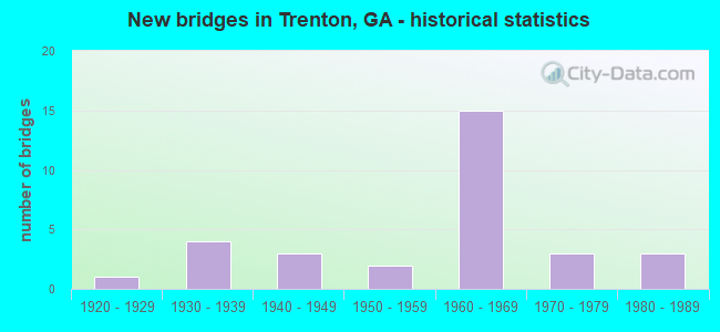
- New bridges - historical statistics
- 11920-1929
- 41930-1939
- 31940-1949
- 21950-1959
- 151960-1969
- 31970-1979
- 31980-1989

- Reconstructed bridges - Historical Statistics
- 11930-1939
- 01940-1949
- 01950-1959
- 11960-1969
- 01970-1979
- 21980-1989
- 11990-1999


- Bridge Condition - Deck
- 31.6%Good
- 47.4%Satisfactory
- 21.1%Fair

- Bridge Condition - Superstructure
- 10.5%Very good
- 42.1%Good
- 47.4%Satisfactory

- Bridge Condition - Substructure
- 68.4%Good
- 26.3%Satisfactory
- 5.3%Fair

- Bridge Condition - Channel
- 77.3%Very good
- 22.7%Good

- Bridge Condition - Culverts
- 75.0%Good
- 16.7%Satisfactory
- 8.3%Fair
Find on map >> Show street view
Structure Number: 830001, Location: 4 MI SW OF TRENTON (Lat: 34.814078, Lng: -85.545719), Route carried "on" structure: County highway 55, Year Built: 1969, Status: Open, Structure Length: 7.99m (26.21ft), Average Daily Traffic: 490 (year 2012), Truck Traffic: 1%, Average Future Daily Traffic: 735 (year 2032), Design Load: HS 15, Features Intersected: I-59 (SR 406), Facility Carried by Structure: BYRDS CHAPEL
Minimum Vertical Clearance: 30+ m (98+ ft), Kilometerpoint: 0.000, Lanes on structure: 2, Lanes under structure: 4, Base Highway Network: Yes, Owner: State Highway Agency, Approaching Roadway Width: 5.8m (19.0ft), Material/Design: Steel continuous, Design/Construction: Stringer/Multi-beam, Number Of Spans In Main Unit: 4, Length of Maximum Span: 26.8m (87.9ft), Curb-To-Curb Width: 9.8m (32.2ft), Out-to-Out Width: 10.5m (34.4ft)
Condition: Deck: Good, Superstructure: Good, Substructure: Good, Operating Rating: 45.3 metric tons, Method Used To Determine Operating Rating: Load Factor (LF), Inventory Rating: 27.2 metric tons, Method Used To Determine Inventory Rating: Load Factor (LF), Structural Evaluation: Equal to present minimum criteria, Deck Geometry: Equal to present minimum criteria, Underclear: Equal to present minimum criteria, Approach Roadway Alignment: Equal to present desirable criteria, Designated Inspection Frequency: Every 24 months, Inspection Date: July 2021, Bridge Improvement Cost: $1,024,000, Roadway Improvement Cost: $102,000, Total Project Cost: $1,536,000, Deck Structure Type: Concrete Cast-file-Place
Find on map >> Show street view
Structure Number: 830005, Location: 4.5 MI SW OF TRENTON (Lat: 34.808819, Lng: -85.542100), Route carried "on" structure: US 11, Year Built: 1921, Year Reconstructed: 1939, Status: Open, Structure Length: 2.93m (9.61ft), Average Daily Traffic: 1,320 (year 2012), Truck Traffic: 8%, Average Future Daily Traffic: 1,980 (year 2032), Design Load: H 15, Features Intersected: CRAWFISH CREEK
Minimum Vertical Clearance: 30+ m (98+ ft), Kilometerpoint: 12.875, Lanes on structure: 2, Base Highway Network: Yes, Owner: State Highway Agency, Approaching Roadway Width: 6.7m (22.0ft), Material/Design: Concrete, Design/Construction: Tee Beam, Number Of Spans In Main Unit: 4, Length of Maximum Span: 7.3m (24.0ft), Curb or Sidewalk Widths: Left: 0.2m (0.7ft), Right: 0.2m (0.7ft), Curb-To-Curb Width: 7.3m (24.0ft), Out-to-Out Width: 7.7m (25.3ft)
Condition: Deck: Fair, Superstructure: Satisfactory, Substructure: Satisfactory, Channel: Very good, Operating Rating: 38.1 metric tons, Method Used To Determine Operating Rating: Load Factor (LF), Inventory Rating: 22.6 metric tons, Method Used To Determine Inventory Rating: Load Factor (LF), Structural Evaluation: Equal to present minimum criteria, Deck Geometry: Meets minimum limits, Waterway Adequacy: Superior to present desirable criteria, Approach Roadway Alignment: Equal to present desirable criteria, Length Of Structure Improvement: 9.36m (30.71ft), Designated Inspection Frequency: Every 24 months, Inspection Date: July 2021, Bridge Improvement Cost: $375,000, Roadway Improvement Cost: $38,000, Total Project Cost: $563,000, Deck Structure Type: Concrete Cast-file-Place
Find on map >> Show street view
Structure Number: 830006, Location: IN TRENTON (Lat: 34.870378, Lng: -85.510339), Route carried "on" structure: US 11, Year Built: 1938, Status: Open, Structure Length: 1.71m (5.61ft), Average Daily Traffic: 11,340 (year 2012), Truck Traffic: 1%, Average Future Daily Traffic: 17,010 (year 2032), Design Load: H 15, Features Intersected: TOWN CREEK
Minimum Vertical Clearance: 30+ m (98+ ft), Kilometerpoint: 19.312, Lanes on structure: 3, Base Highway Network: Yes, Owner: State Highway Agency, Approaching Roadway Width: 13.4m (44.0ft), Material/Design: Concrete, Design/Construction: Culvert, Number Of Spans In Main Unit: 5, Length of Maximum Span: 3.0m (9.8ft), Curb or Sidewalk Widths: Left: 1.5m (4.9ft), Right: 1.5m (4.9ft)
Condition: Channel: Very good, Culverts: Good, Operating Rating: 41.7 metric tons, Method Used To Determine Operating Rating: Field evaluation and documented engineering judgment, Inventory Rating: 24.4 metric tons, Method Used To Determine Inventory Rating: Field evaluation and documented engineering judgment, Structural Evaluation: Equal to present minimum criteria, Waterway Adequacy: Superior to present desirable criteria, Approach Roadway Alignment: Equal to present desirable criteria, Designated Inspection Frequency: Every 24 months, Inspection Date: June 2021, Bridge Improvement Cost: $278,000, Roadway Improvement Cost: $28,000, Total Project Cost: $418,000
Find on map >> Show street view
Structure Number: 830007, Location: IN NEW ENGLAND (Lat: 34.917189, Lng: -85.475928), Route carried "on" structure: US 11, Year Built: 1936, Year Reconstructed: 1960, Status: Open, Structure Length: 3.66m (12.01ft), Average Daily Traffic: 4,400 (year 2012), Truck Traffic: 1%, Average Future Daily Traffic: 6,600 (year 2032), Design Load: H 15, Features Intersected: SQUIRREL TOWN CREEK
Minimum Vertical Clearance: 30+ m (98+ ft), Kilometerpoint: 25.750, Lanes on structure: 2, Base Highway Network: Yes, Owner: State Highway Agency, Approaching Roadway Width: 8.5m (27.9ft), Material/Design: Steel, Design/Construction: Stringer/Multi-beam, Number Of Spans In Main Unit: 3, Length of Maximum Span: 15.2m (49.9ft), Curb or Sidewalk Widths: Left: 0.7m (2.3ft), Right: 0.7m (2.3ft), Curb-To-Curb Width: 8.5m (27.9ft), Out-to-Out Width: 10.2m (33.5ft)
Condition: Deck: Fair, Superstructure: Satisfactory, Substructure: Satisfactory, Channel: Very good, Operating Rating: 44.4 metric tons, Method Used To Determine Operating Rating: Load Factor (LF), Inventory Rating: 26.3 metric tons, Method Used To Determine Inventory Rating: Load Factor (LF), Structural Evaluation: Equal to present minimum criteria, Deck Geometry: Meets minimum limits, Waterway Adequacy: Superior to present desirable criteria, Approach Roadway Alignment: Equal to present desirable criteria, Designated Inspection Frequency: Every 24 months, Inspection Date: July 2021, Bridge Improvement Cost: $469,000, Roadway Improvement Cost: $47,000, Total Project Cost: $703,000, Deck Structure Type: Concrete Cast-file-Place
Find on map >> Show street view
Structure Number: 830009, Location: 3 MI SW OF TRENTON (Lat: 34.831619, Lng: -85.535419), Route carried "on" structure: County highway 104, Year Built: 1969, Status: Posted for load, Structure Length: 8.11m (26.61ft), Average Daily Traffic: 490 (year 2012), Truck Traffic: 1%, Average Future Daily Traffic: 735 (year 2032), Design Load: HS 15, Features Intersected: I-59 (SR 406), Facility Carried by Structure: DANIELS ROAD
Minimum Vertical Clearance: 30+ m (98+ ft), Kilometerpoint: 0.000, Lanes on structure: 2, Lanes under structure: 4, Base Highway Network: Yes, Owner: State Highway Agency, Approaching Roadway Width: 6.1m (20.0ft), Skew: 1 degrees, Material/Design: Steel continuous, Design/Construction: Stringer/Multi-beam, Number Of Spans In Main Unit: 4, Length of Maximum Span: 27.1m (88.9ft), Curb-To-Curb Width: 9.8m (32.2ft), Out-to-Out Width: 10.5m (34.4ft)
Condition: Deck: Good, Superstructure: Good, Substructure: Good, Operating Rating: 43.5 metric tons, Method Used To Determine Operating Rating: Load Factor (LF), Inventory Rating: 25.4 metric tons, Method Used To Determine Inventory Rating: Load Factor (LF), Structural Evaluation: Equal to present minimum criteria, Deck Geometry: Equal to present minimum criteria, Underclear: Better than present minimum criteria, Approach Roadway Alignment: Equal to present desirable criteria, Designated Inspection Frequency: Every 24 months, Inspection Date: July 2021, Bridge Improvement Cost: $1,039,000, Roadway Improvement Cost: $104,000, Total Project Cost: $1,559,000, Deck Structure Type: Concrete Cast-file-Place
Find on map >> Show street view
Structure Number: 830011, Location: 3.5 MI W OF TRENTON (Lat: 34.865158, Lng: -85.574458), Route carried "on" structure: State highway 136, Year Built: 1940, Status: Open, Structure Length: 1.10m (3.61ft), Average Daily Traffic: 3,780 (year 2012), Truck Traffic: 6%, Average Future Daily Traffic: 5,670 (year 2032), Design Load: H 15, Features Intersected: BIG HIGDON CREEK
Minimum Vertical Clearance: 30+ m (98+ ft), Kilometerpoint: 1.609, Lanes on structure: 2, Base Highway Network: Yes, Owner: State Highway Agency, Approaching Roadway Width: 7.9m (25.9ft), Skew: 2 degrees, Material/Design: Concrete, Design/Construction: Culvert, Number Of Spans In Main Unit: 3, Length of Maximum Span: 3.4m (11.2ft)
Condition: Channel: Good, Culverts: Good, Operating Rating: 41.7 metric tons, Method Used To Determine Operating Rating: Field evaluation and documented engineering judgment, Inventory Rating: 24.4 metric tons, Method Used To Determine Inventory Rating: Field evaluation and documented engineering judgment, Structural Evaluation: Equal to present minimum criteria, Waterway Adequacy: Superior to present desirable criteria, Approach Roadway Alignment: Equal to present minimum criteria, Designated Inspection Frequency: Every 24 months, Inspection Date: July 2021, Bridge Improvement Cost: $141,000, Roadway Improvement Cost: $14,000, Total Project Cost: $211,000
Find on map >> Show street view
Structure Number: 830012, Location: IN TRENTON (Lat: 34.869589, Lng: -85.515978), Route carried "on" structure: State highway 136, Year Built: 1967, Year Reconstructed: 2001, Status: Open, Structure Length: 8.32m (27.30ft), Average Daily Traffic: 13,880 (year 2012), Truck Traffic: 1%, Average Future Daily Traffic: 20,820 (year 2032), Design Load: HS 20+Mod, Features Intersected: I-59 (SR 406)
Minimum Vertical Clearance: 30+ m (98+ ft), Kilometerpoint: 8.047, Lanes on structure: 5, Lanes under structure: 4, Base Highway Network: Yes, Owner: State Highway Agency, Approaching Roadway Width: 21.6m (70.9ft), Skew: 1 degrees, Material/Design: Steel, Design/Construction: Stringer/Multi-beam, Number Of Spans In Main Unit: 4, Length of Maximum Span: 22.3m (73.2ft), Curb or Sidewalk Widths: Left: 2.0m (6.6ft), Right: 2.0m (6.6ft), Curb-To-Curb Width: 22.1m (72.5ft), Out-to-Out Width: 26.5m (86.9ft)
Condition: Deck: Satisfactory, Superstructure: Good, Substructure: Fair, Operating Rating: 36.2 metric tons, Method Used To Determine Operating Rating: Load Factor (LF), Inventory Rating: 21.7 metric tons, Method Used To Determine Inventory Rating: Load Factor (LF), Structural Evaluation: Somewhat better than minimum adequacy, Deck Geometry: Somewhat better than minimum adequacy, Underclear: Meets minimum limits, Approach Roadway Alignment: Equal to present desirable criteria, Designated Inspection Frequency: Every 24 months, Inspection Date: June 2021, Bridge Improvement Cost: $1,939,000, Roadway Improvement Cost: $194,000, Total Project Cost: $2,909,000, Deck Structure Type: Concrete Cast-file-Place
Find on map >> Show street view
Structure Number: 830013, Location: IN E SIDE OF TRENTON (Lat: 34.865497, Lng: -85.509489), Route carried "on" structure: State highway 136, Year Built: 1942, Year Reconstructed: 1988, Status: Open, Structure Length: 6.86m (22.51ft), Average Daily Traffic: 7,210 (year 2012), Truck Traffic: 1%, Average Future Daily Traffic: 10,815 (year 2032), Design Load: H 15, Features Intersected: NORSOUTHERN RR (725782V)
Minimum Vertical Clearance: 30+ m (98+ ft), Kilometerpoint: 9.656, Lanes on structure: 2, Base Highway Network: Yes, Owner: State Highway Agency, Approaching Roadway Width: 7.3m (24.0ft), Material/Design: Steel, Design/Construction: Stringer/Multi-beam, Number Of Spans In Main Unit: 5, Length of Maximum Span: 13.7m (44.9ft), Curb-To-Curb Width: 13.4m (44.0ft), Out-to-Out Width: 14.4m (47.2ft)
Condition: Deck: Good, Superstructure: Satisfactory, Substructure: Satisfactory, Operating Rating: 34.4 metric tons, Method Used To Determine Operating Rating: Load Factor (LF), Inventory Rating: 20.8 metric tons, Method Used To Determine Inventory Rating: Load Factor (LF), Structural Evaluation: Somewhat better than minimum adequacy, Deck Geometry: Equal to present minimum criteria, Underclear: Somewhat better than minimum adequacy, Approach Roadway Alignment: Equal to present desirable criteria, Designated Inspection Frequency: Every 24 months, Inspection Date: June 2021, Bridge Improvement Cost: $879,000, Roadway Improvement Cost: $88,000, Total Project Cost: $1,319,000, Deck Structure Type: Concrete Cast-file-Place
Find on map >> Show street view
Structure Number: 830014, Location: @ E CITY LIMIT OF TRENTON (Lat: 34.862850, Lng: -85.500619), Route carried "on" structure: State highway 136, Year Built: 1940, Year Reconstructed: 1988, Status: Open, Structure Length: 4.27m (14.01ft), Average Daily Traffic: 7,210 (year 2012), Truck Traffic: 1%, Average Future Daily Traffic: 10,815 (year 2032), Design Load: H 15, Features Intersected: LOOKOUT CREEK
Minimum Vertical Clearance: 30+ m (98+ ft), Kilometerpoint: 9.656, Lanes on structure: 2, Base Highway Network: Yes, Owner: State Highway Agency, Approaching Roadway Width: 7.3m (24.0ft), Material/Design: Steel, Design/Construction: Stringer/Multi-beam, Number Of Spans In Main Unit: 4, Length of Maximum Span: 10.7m (35.1ft), Curb-To-Curb Width: 13.4m (44.0ft), Out-to-Out Width: 14.4m (47.2ft)
Condition: Deck: Fair, Superstructure: Satisfactory, Substructure: Satisfactory, Channel: Very good, Operating Rating: 45.3 metric tons, Method Used To Determine Operating Rating: Load Factor (LF), Inventory Rating: 27.2 metric tons, Method Used To Determine Inventory Rating: Load Factor (LF), Structural Evaluation: Equal to present minimum criteria, Deck Geometry: Equal to present minimum criteria, Waterway Adequacy: Superior to present desirable criteria, Approach Roadway Alignment: Equal to present desirable criteria, Designated Inspection Frequency: Every 24 months, Inspection Date: July 2021, Bridge Improvement Cost: $547,000, Roadway Improvement Cost: $55,000, Total Project Cost: $821,000, Deck Structure Type: Concrete Cast-file-Place
Find on map >> Show street view
Structure Number: 830015, Location: 4 MI SE OF TRENTON (Lat: 34.816239, Lng: -85.491119), Route carried "on" structure: State highway 136, Year Built: 1939, Status: Open, Structure Length: 0.91m (2.99ft), Average Daily Traffic: 2,550 (year 2012), Truck Traffic: 7%, Average Future Daily Traffic: 3,825 (year 2032), Design Load: H 15, Features Intersected: DANIEL CREEK
Minimum Vertical Clearance: 30+ m (98+ ft), Kilometerpoint: 17.703, Lanes on structure: 2, Base Highway Network: Yes, Owner: State Highway Agency, Approaching Roadway Width: 7.3m (24.0ft), Material/Design: Steel, Design/Construction: Culvert, Number Of Spans In Main Unit: 2, Length of Maximum Span: 3.7m (12.1ft)
Condition: Channel: Very good, Culverts: Satisfactory, Operating Rating: 41.7 metric tons, Method Used To Determine Operating Rating: Field evaluation and documented engineering judgment, Inventory Rating: 24.4 metric tons, Method Used To Determine Inventory Rating: Field evaluation and documented engineering judgment, Structural Evaluation: Equal to present minimum criteria, Waterway Adequacy: Superior to present desirable criteria, Approach Roadway Alignment: Equal to present desirable criteria, Designated Inspection Frequency: Every 24 months, Inspection Date: July 2021, Bridge Improvement Cost: $117,000, Roadway Improvement Cost: $12,000, Total Project Cost: $176,000
Find on map >> Show street view
Structure Number: 830018, Location: IN N SIDE OF NEW ENGLAND (Lat: 34.922439, Lng: -85.481869), Route carried "on" structure: County highway 186, Year Built: 1967, Status: Open, Structure Length: 10.73m (35.20ft), Average Daily Traffic: 490 (year 2012), Truck Traffic: 6%, Average Future Daily Traffic: 735 (year 2032), Design Load: HS 20+Mod, Features Intersected: I-59 (SR 406), Facility Carried by Structure: OLD HALE GAP RD
Minimum Vertical Clearance: 30+ m (98+ ft), Kilometerpoint: 3.219, Lanes on structure: 2, Lanes under structure: 4, Base Highway Network: Yes, Owner: State Highway Agency, Approaching Roadway Width: 5.8m (19.0ft), Skew: 4 degrees, Material/Design: Steel continuous, Design/Construction: Stringer/Multi-beam, Number Of Spans In Main Unit: 4, Length of Maximum Span: 32.6m (107.0ft), Curb or Sidewalk Widths: Left: 0.6m (2.0ft), Right: 0.6m (2.0ft), Curb-To-Curb Width: 8.5m (27.9ft), Out-to-Out Width: 10.4m (34.1ft)
Condition: Deck: Satisfactory, Superstructure: Very good, Substructure: Satisfactory, Operating Rating: 56.2 metric tons, Method Used To Determine Operating Rating: Load Factor (LF), Inventory Rating: 33.5 metric tons, Method Used To Determine Inventory Rating: Load Factor (LF), Structural Evaluation: Equal to present minimum criteria, Deck Geometry: Somewhat better than minimum adequacy, Underclear: Somewhat better than minimum adequacy, Approach Roadway Alignment: Equal to present desirable criteria, Designated Inspection Frequency: Every 24 months, Inspection Date: July 2021, Bridge Improvement Cost: $1,375,000, Roadway Improvement Cost: $138,000, Total Project Cost: $2,063,000, Deck Structure Type: Concrete Cast-file-Place
Find on map >> Show street view
Structure Number: 830019, Location: 4 MI SE OF TRENTON (Lat: 34.828239, Lng: -85.459350), Route carried "on" structure: State highway 189, Year Built: 1936, Status: Open, Structure Length: 1.13m (3.71ft), Average Daily Traffic: 660 (year 2012), Truck Traffic: 6%, Average Future Daily Traffic: 990 (year 2032), Design Load: H 15, Features Intersected: BEAR CREEK
Minimum Vertical Clearance: 30+ m (98+ ft), Kilometerpoint: 3.219, Lanes on structure: 2, Base Highway Network: Yes, Owner: State Highway Agency, Approaching Roadway Width: 6.7m (22.0ft), Skew: 3 degrees, Material/Design: Concrete, Design/Construction: Culvert, Number Of Spans In Main Unit: 3, Length of Maximum Span: 3.7m (12.1ft)
Condition: Channel: Good, Culverts: Fair, Operating Rating: 41.7 metric tons, Method Used To Determine Operating Rating: Field evaluation and documented engineering judgment, Inventory Rating: 24.4 metric tons, Method Used To Determine Inventory Rating: Field evaluation and documented engineering judgment, Structural Evaluation: Somewhat better than minimum adequacy, Waterway Adequacy: Superior to present desirable criteria, Approach Roadway Alignment: Equal to present desirable criteria, Designated Inspection Frequency: Every 24 months, Inspection Date: July 2021, Bridge Improvement Cost: $145,000, Roadway Improvement Cost: $14,000, Total Project Cost: $217,000
Find on map >> Show street view
Structure Number: 830023, Location: 3.8 MI SW OF TRENTON (Lat: 34.811689, Lng: -85.546939), Route carried "on" structure: Interstate 59, Year Built: 1969, Status: Open, Structure Length: 3.93m (12.89ft), Average Daily Traffic: 12,920 (year 2012), Truck Traffic: 32%, Average Future Daily Traffic: 19,380 (year 2032), Design Load: HS 20+Mod, Features Intersected: CRAWFISH CREEK
Minimum Vertical Clearance: 30+ m (98+ ft), Kilometerpoint: 11.265, Lanes on structure: 2, Base Highway Network: Yes, Owner: State Highway Agency, Approaching Roadway Width: 11.6m (38.1ft), Skew: 12 degrees, Material/Design: Steel, Design/Construction: Stringer/Multi-beam, Number Of Spans In Main Unit: 3, Length of Maximum Span: 13.1m (43.0ft), Curb-To-Curb Width: 12.8m (42.0ft), Out-to-Out Width: 13.5m (44.3ft)
Condition: Deck: Satisfactory, Superstructure: Satisfactory, Substructure: Good, Channel: Good, Operating Rating: 40.8 metric tons, Method Used To Determine Operating Rating: Load Factor (LF), Inventory Rating: 24.4 metric tons, Method Used To Determine Inventory Rating: Load Factor (LF), Structural Evaluation: Equal to present minimum criteria, Deck Geometry: Equal to present desirable criteria, Waterway Adequacy: Superior to present desirable criteria, Approach Roadway Alignment: Equal to present desirable criteria, Designated Inspection Frequency: Every 24 months, Inspection Date: July 2021, Bridge Improvement Cost: $504,000, Roadway Improvement Cost: $50,000, Total Project Cost: $756,000, Deck Structure Type: Concrete Cast-file-Place
Find on map >> Show street view
Structure Number: 830024, Location: 3.8 MI SW OF TRENTON (Lat: 34.811689, Lng: -85.547278), Route carried "on" structure: Interstate 59, Year Built: 1969, Status: Open, Structure Length: 4.02m (13.19ft), Average Daily Traffic: 12,920 (year 2012), Truck Traffic: 32%, Average Future Daily Traffic: 19,380 (year 2032), Design Load: HS 20+Mod, Features Intersected: CRAWFISH CREEK
Minimum Vertical Clearance: 30+ m (98+ ft), Kilometerpoint: 11.265, Lanes on structure: 2, Base Highway Network: Yes, Owner: State Highway Agency, Approaching Roadway Width: 11.6m (38.1ft), Skew: 12 degrees, Material/Design: Steel, Design/Construction: Stringer/Multi-beam, Number Of Spans In Main Unit: 3, Length of Maximum Span: 14.0m (45.9ft), Curb-To-Curb Width: 12.8m (42.0ft), Out-to-Out Width: 13.5m (44.3ft)
Condition: Deck: Satisfactory, Superstructure: Good, Substructure: Good, Channel: Good, Operating Rating: 34.4 metric tons, Method Used To Determine Operating Rating: Load Factor (LF), Inventory Rating: 20.8 metric tons, Method Used To Determine Inventory Rating: Load Factor (LF), Structural Evaluation: Somewhat better than minimum adequacy, Deck Geometry: Equal to present desirable criteria, Waterway Adequacy: Superior to present desirable criteria, Approach Roadway Alignment: Equal to present desirable criteria, Designated Inspection Frequency: Every 24 months, Inspection Date: July 2021, Bridge Improvement Cost: $516,000, Roadway Improvement Cost: $52,000, Total Project Cost: $774,000, Deck Structure Type: Concrete Cast-file-Place
Find on map >> Show street view
Structure Number: 830025, Location: IN NORTH TRENTON (Lat: 34.888758, Lng: -85.503569), Route carried "on" structure: Interstate 59, Year Built: 1967, Status: Open, Structure Length: 3.38m (11.09ft), Average Daily Traffic: 18,660 (year 2012), Truck Traffic: 1%, Average Future Daily Traffic: 27,990 (year 2032), Design Load: HS 20+Mod, Features Intersected: CR 141 LAKE HILLS DRIVE
Minimum Vertical Clearance: 30+ m (98+ ft), Kilometerpoint: 20.921, Lanes on structure: 2, Lanes under structure: 2, Base Highway Network: Yes, Owner: State Highway Agency, Approaching Roadway Width: 11.6m (38.1ft), Skew: 11 degrees, Material/Design: Concrete continuous, Design/Construction: Tee Beam, Number Of Spans In Main Unit: 3, Length of Maximum Span: 13.7m (44.9ft), Curb or Sidewalk Widths: Left: 0.6m (2.0ft), Right: 0.6m (2.0ft), Curb-To-Curb Width: 11.7m (38.4ft), Out-to-Out Width: 13.3m (43.6ft)
Condition: Deck: Fair, Superstructure: Satisfactory, Substructure: Good, Operating Rating: 46.2 metric tons, Method Used To Determine Operating Rating: Allowable Stress (AS), Inventory Rating: 32.6 metric tons, Method Used To Determine Inventory Rating: Allowable Stress (AS), Structural Evaluation: Equal to present minimum criteria, Deck Geometry: Equal to present minimum criteria, Underclear: High priority of corrective action, Approach Roadway Alignment: Equal to present desirable criteria, Designated Inspection Frequency: Every 24 months, Inspection Date: July 2021, Bridge Improvement Cost: $434,000, Roadway Improvement Cost: $43,000, Total Project Cost: $651,000, Deck Structure Type: Concrete Cast-file-Place
Find on map >> Show street view
Structure Number: 830026, Location: IN NORTH TRENTON (Lat: 34.888919, Lng: -85.503789), Route carried "on" structure: Interstate 59, Year Built: 1967, Status: Open, Structure Length: 3.38m (11.09ft), Average Daily Traffic: 18,660 (year 2012), Truck Traffic: 1%, Average Future Daily Traffic: 27,990 (year 2032), Design Load: HS 20+Mod, Features Intersected: CR 141 LAKE HILLS DRIVE
Minimum Vertical Clearance: 30+ m (98+ ft), Kilometerpoint: 20.921, Lanes on structure: 2, Lanes under structure: 2, Base Highway Network: Yes, Owner: State Highway Agency, Approaching Roadway Width: 11.6m (38.1ft), Skew: 11 degrees, Material/Design: Concrete continuous, Design/Construction: Tee Beam, Number Of Spans In Main Unit: 3, Length of Maximum Span: 13.7m (44.9ft), Curb or Sidewalk Widths: Left: 0.6m (2.0ft), Right: 0.6m (2.0ft), Curb-To-Curb Width: 11.7m (38.4ft), Out-to-Out Width: 13.3m (43.6ft)
Condition: Deck: Satisfactory, Superstructure: Satisfactory, Substructure: Good, Operating Rating: 46.2 metric tons, Method Used To Determine Operating Rating: Allowable Stress (AS), Inventory Rating: 32.6 metric tons, Method Used To Determine Inventory Rating: Allowable Stress (AS), Structural Evaluation: Equal to present minimum criteria, Deck Geometry: Equal to present minimum criteria, Underclear: High priority of corrective action, Approach Roadway Alignment: Equal to present desirable criteria, Designated Inspection Frequency: Every 24 months, Inspection Date: July 2021, Bridge Improvement Cost: $434,000, Roadway Improvement Cost: $43,000, Total Project Cost: $651,000, Deck Structure Type: Concrete Cast-file-Place
Find on map >> Show street view
Structure Number: 830027, Location: IN NEW ENGLAND (Lat: 34.906678, Lng: -85.489319), Route carried "on" structure: Interstate 59, Year Built: 1967, Status: Open, Structure Length: 2.93m (9.61ft), Average Daily Traffic: 18,660 (year 2012), Truck Traffic: 1%, Average Future Daily Traffic: 27,990 (year 2032), Design Load: HS 20+Mod, Features Intersected: CR 271 HICKS HOLLOW RD
Minimum Vertical Clearance: 30+ m (98+ ft), Kilometerpoint: 22.531, Lanes on structure: 2, Lanes under structure: 2, Base Highway Network: Yes, Owner: State Highway Agency, Approaching Roadway Width: 11.6m (38.1ft), Skew: 10 degrees, Material/Design: Concrete continuous, Design/Construction: Tee Beam, Number Of Spans In Main Unit: 3, Length of Maximum Span: 11.6m (38.1ft), Curb or Sidewalk Widths: Left: 0.6m (2.0ft), Right: 0.6m (2.0ft), Curb-To-Curb Width: 11.8m (38.7ft), Out-to-Out Width: 13.7m (44.9ft)
Condition: Deck: Satisfactory, Superstructure: Satisfactory, Substructure: Good, Operating Rating: 47.1 metric tons, Method Used To Determine Operating Rating: Load Factor (LF), Inventory Rating: 28.1 metric tons, Method Used To Determine Inventory Rating: Load Factor (LF), Structural Evaluation: Equal to present minimum criteria, Deck Geometry: Equal to present minimum criteria, Underclear: High priority of corrective action, Approach Roadway Alignment: Equal to present desirable criteria, Designated Inspection Frequency: Every 24 months, Inspection Date: July 2021, Bridge Improvement Cost: $375,000, Roadway Improvement Cost: $38,000, Total Project Cost: $563,000, Deck Structure Type: Concrete Cast-file-Place
Find on map >> Show street view
Structure Number: 830028, Location: IN NEW ENGLAND (Lat: 34.906839, Lng: -85.489539), Route carried "on" structure: Interstate 59, Year Built: 1967, Status: Open, Structure Length: 2.93m (9.61ft), Average Daily Traffic: 18,660 (year 2012), Truck Traffic: 1%, Average Future Daily Traffic: 27,990 (year 2032), Design Load: HS 20+Mod, Features Intersected: CR 271 HICKS HOLLOW RD
Minimum Vertical Clearance: 30+ m (98+ ft), Kilometerpoint: 22.531, Lanes on structure: 2, Lanes under structure: 2, Base Highway Network: Yes, Owner: State Highway Agency, Approaching Roadway Width: 11.6m (38.1ft), Skew: 10 degrees, Material/Design: Concrete continuous, Design/Construction: Tee Beam, Number Of Spans In Main Unit: 3, Length of Maximum Span: 11.6m (38.1ft), Curb or Sidewalk Widths: Left: 0.6m (2.0ft), Right: 0.6m (2.0ft), Curb-To-Curb Width: 11.7m (38.4ft), Out-to-Out Width: 13.7m (44.9ft)
Condition: Deck: Satisfactory, Superstructure: Satisfactory, Substructure: Good, Operating Rating: 47.1 metric tons, Method Used To Determine Operating Rating: Load Factor (LF), Inventory Rating: 28.1 metric tons, Method Used To Determine Inventory Rating: Load Factor (LF), Structural Evaluation: Equal to present minimum criteria, Deck Geometry: Equal to present minimum criteria, Underclear: Meets minimum limits, Approach Roadway Alignment: Equal to present desirable criteria, Designated Inspection Frequency: Every 24 months, Inspection Date: July 2021, Bridge Improvement Cost: $375,000, Roadway Improvement Cost: $38,000, Total Project Cost: $563,000, Deck Structure Type: Concrete Cast-file-Place
Find on map >> Show street view
Structure Number: 830029, Location: 1.5 MI N OF NEW ENGLAND (Lat: 34.929389, Lng: -85.483969), Route carried "on" structure: Interstate 59, Year Built: 1967, Status: Open, Structure Length: 3.66m (12.01ft), Average Daily Traffic: 18,660 (year 2012), Truck Traffic: 1%, Average Future Daily Traffic: 27,990 (year 2032), Design Load: HS 20+Mod, Features Intersected: SQUIRREL TOWN CREEK
Minimum Vertical Clearance: 30+ m (98+ ft), Kilometerpoint: 25.750, Lanes on structure: 2, Base Highway Network: Yes, Owner: State Highway Agency, Approaching Roadway Width: 11.6m (38.1ft), Skew: 13 degrees, Material/Design: Concrete continuous, Design/Construction: Tee Beam, Number Of Spans In Main Unit: 3, Length of Maximum Span: 14.0m (45.9ft), Curb or Sidewalk Widths: Left: 0.6m (2.0ft), Right: 0.6m (2.0ft), Curb-To-Curb Width: 11.8m (38.7ft), Out-to-Out Width: 13.6m (44.6ft)
Condition: Deck: Satisfactory, Superstructure: Good, Substructure: Good, Channel: Very good, Operating Rating: 55.3 metric tons, Method Used To Determine Operating Rating: Load Factor (LF), Inventory Rating: 32.6 metric tons, Method Used To Determine Inventory Rating: Load Factor (LF), Structural Evaluation: Better than present minimum criteria, Deck Geometry: Equal to present minimum criteria, Waterway Adequacy: Superior to present desirable criteria, Approach Roadway Alignment: Equal to present desirable criteria, Designated Inspection Frequency: Every 24 months, Inspection Date: July 2021, Bridge Improvement Cost: $469,000, Roadway Improvement Cost: $47,000, Total Project Cost: $703,000, Deck Structure Type: Concrete Cast-file-Place
Find on map >> Show street view
Structure Number: 83003, Location: 1.5 MI N OF NEW ENGLAND (Lat: 34.929269, Lng: -85.483647), Route carried "on" structure: Interstate 59, Year Built: 1967, Status: Open, Structure Length: 3.66m (12.01ft), Average Daily Traffic: 18,660 (year 2012), Truck Traffic: 1%, Average Future Daily Traffic: 27,990 (year 2032), Design Load: HS 20+Mod, Features Intersected: SQUIRREL TOWN CREEK
Minimum Vertical Clearance: 30+ m (98+ ft), Kilometerpoint: 25.750, Lanes on structure: 2, Base Highway Network: Yes, Owner: State Highway Agency, Approaching Roadway Width: 11.6m (38.1ft), Skew: 13 degrees, Material/Design: Concrete continuous, Design/Construction: Tee Beam, Number Of Spans In Main Unit: 3, Length of Maximum Span: 14.0m (45.9ft), Curb or Sidewalk Widths: Left: 0.6m (2.0ft), Right: 0.6m (2.0ft), Curb-To-Curb Width: 11.8m (38.7ft), Out-to-Out Width: 13.6m (44.6ft)
Condition: Deck: Satisfactory, Superstructure: Good, Substructure: Good, Channel: Very good, Operating Rating: 55.3 metric tons, Method Used To Determine Operating Rating: Load Factor (LF), Inventory Rating: 32.6 metric tons, Method Used To Determine Inventory Rating: Load Factor (LF), Structural Evaluation: Better than present minimum criteria, Deck Geometry: Equal to present minimum criteria, Waterway Adequacy: Superior to present desirable criteria, Approach Roadway Alignment: Equal to present desirable criteria, Designated Inspection Frequency: Every 24 months, Inspection Date: July 2021, Bridge Improvement Cost: $469,000, Roadway Improvement Cost: $47,000, Total Project Cost: $703,000, Deck Structure Type: Concrete Cast-file-Place
Find on map >> Show street view
Structure Number: 830031, Location: 2 MI N OF NEW ENGLAND (Lat: 34.935728, Lng: -85.482989), Route carried "on" structure: Interstate 59, Year Built: 1967, Status: Open, Structure Length: 0.82m (2.69ft), Average Daily Traffic: 18,660 (year 2012), Truck Traffic: 1%, Average Future Daily Traffic: 27,990 (year 2032), Design Load: HS 20+Mod, Features Intersected: DRY WASH BRANCH
Minimum Vertical Clearance: 30+ m (98+ ft), Kilometerpoint: 25.750, Lanes on structure: 2, Base Highway Network: Yes, Owner: State Highway Agency, Approaching Roadway Width: 11.6m (38.1ft), Skew: 14 degrees, Material/Design: Concrete, Design/Construction: Culvert, Number Of Spans In Main Unit: 2, Length of Maximum Span: 4.0m (13.1ft)
Condition: Channel: Very good, Culverts: Good, Operating Rating: 67.1 metric tons, Method Used To Determine Operating Rating: Load Factor (LF), Inventory Rating: 40.8 metric tons, Method Used To Determine Inventory Rating: Load Factor (LF), Structural Evaluation: Better than present minimum criteria, Waterway Adequacy: Superior to present desirable criteria, Approach Roadway Alignment: Equal to present desirable criteria, Designated Inspection Frequency: Every 24 months, Inspection Date: July 2021, Bridge Improvement Cost: $105,000, Roadway Improvement Cost: $11,000, Total Project Cost: $158,000
Find on map >> Show street view
Structure Number: 830032, Location: 2 MI N OF NEW ENGLAND (Lat: 34.936639, Lng: -85.483147), Route carried "on" structure: Interstate 59, Year Built: 1967, Status: Open, Structure Length: 0.67m (2.20ft), Average Daily Traffic: 18,660 (year 2012), Truck Traffic: 1%, Average Future Daily Traffic: 27,990 (year 2032), Design Load: HS 20+Mod, Features Intersected: DRY WASH BRANCH
Minimum Vertical Clearance: 30+ m (98+ ft), Kilometerpoint: 25.750, Lanes on structure: 2, Base Highway Network: Yes, Owner: State Highway Agency, Approaching Roadway Width: 11.6m (38.1ft), Skew: 13 degrees, Material/Design: Concrete, Design/Construction: Culvert, Number Of Spans In Main Unit: 2, Length of Maximum Span: 3.0m (9.8ft)
Condition: Channel: Very good, Culverts: Good, Operating Rating: 45.3 metric tons, Method Used To Determine Operating Rating: Load Factor (LF), Inventory Rating: 27.2 metric tons, Method Used To Determine Inventory Rating: Load Factor (LF), Structural Evaluation: Equal to present minimum criteria, Waterway Adequacy: Superior to present desirable criteria, Approach Roadway Alignment: Equal to present desirable criteria, Designated Inspection Frequency: Every 24 months, Inspection Date: July 2021, Bridge Improvement Cost: $86,000, Roadway Improvement Cost: $9,000, Total Project Cost: $129,000
Find on map >> Show street view
Structure Number: 830046, Location: 1.5 MI E OF TRENTON (Lat: 34.870358, Lng: -85.489997), Route carried "on" structure: County highway 201, Year Built: 1981, Status: Open, Structure Length: 1.22m (4.00ft), Average Daily Traffic: 1,100 (year 2012), Truck Traffic: 1%, Average Future Daily Traffic: 1,650 (year 2032), Features Intersected: SITTON GULCH (DRY WASH), Facility Carried by Structure: PINEY ROAD
Minimum Vertical Clearance: 30+ m (98+ ft), Kilometerpoint: 1.609, Lanes on structure: 2, Base Highway Network: Yes, Owner: County Highway Agency, Approaching Roadway Width: 6.1m (20.0ft), Material/Design: Steel, Design/Construction: Stringer/Multi-beam, Number Of Spans In Main Unit: 2, Length of Maximum Span: 6.1m (20.0ft), Curb-To-Curb Width: 7.1m (23.3ft), Out-to-Out Width: 7.3m (24.0ft)
Condition: Deck: Good, Superstructure: Good, Substructure: Good, Channel: Very good, Operating Rating: 56.2 metric tons, Method Used To Determine Operating Rating: Load Factor (LF), Inventory Rating: 33.5 metric tons, Method Used To Determine Inventory Rating: Load Factor (LF), Structural Evaluation: Better than present minimum criteria, Deck Geometry: High priority of corrective action, Waterway Adequacy: Equal to present desirable criteria, Approach Roadway Alignment: Equal to present desirable criteria, Length Of Structure Improvement: 7.65m (25.10ft), Designated Inspection Frequency: Every 24 months, Inspection Date: July 2021, Bridge Improvement Cost: $156,000, Roadway Improvement Cost: $16,000, Total Project Cost: $234,000, Deck Structure Type: Concrete Cast-file-Place, Wearing Surface/Protective System: Wearing Surface: Bituminous
Find on map >> Show street view
Structure Number: 830047, Location: 1.6 MI E OF TRENTON (Lat: 34.871458, Lng: -85.488419), Route carried "on" structure: County highway 201, Year Built: 1953, Status: Open, Structure Length: 0.64m (2.10ft), Average Daily Traffic: 1,100 (year 2012), Truck Traffic: 1%, Average Future Daily Traffic: 1,650 (year 2032), Design Load: H 15, Features Intersected: SITTON GULCH CREEK TRIB., Facility Carried by Structure: PINEY ROAD
Minimum Vertical Clearance: 30+ m (98+ ft), Kilometerpoint: 1.609, Lanes on structure: 2, Base Highway Network: Yes, Owner: County Highway Agency, Approaching Roadway Width: 6.1m (20.0ft), Material/Design: Concrete, Design/Construction: Culvert, Number Of Spans In Main Unit: 2, Length of Maximum Span: 3.0m (9.8ft)
Condition: Channel: Very good, Culverts: Good, Operating Rating: 41.7 metric tons, Method Used To Determine Operating Rating: Field evaluation and documented engineering judgment, Inventory Rating: 24.4 metric tons, Method Used To Determine Inventory Rating: Field evaluation and documented engineering judgment, Structural Evaluation: Equal to present minimum criteria, Waterway Adequacy: Equal to present minimum criteria, Approach Roadway Alignment: Equal to present desirable criteria, Designated Inspection Frequency: Every 24 months, Inspection Date: July 2021, Bridge Improvement Cost: $82,000, Roadway Improvement Cost: $8,000, Total Project Cost: $123,000
Find on map >> Show street view
Structure Number: 830048, Location: 1.8 MI E OF TRENTON (Lat: 34.873578, Lng: -85.484628), Route carried "on" structure: County highway 201, Year Built: 1953, Status: Open, Structure Length: 0.98m (3.22ft), Average Daily Traffic: 1,100 (year 2012), Truck Traffic: 1%, Average Future Daily Traffic: 1,650 (year 2032), Design Load: H 15, Features Intersected: JACK BRANCH, Facility Carried by Structure: PINEY ROAD
Minimum Vertical Clearance: 30+ m (98+ ft), Kilometerpoint: 1.609, Lanes on structure: 2, Base Highway Network: Yes, Owner: County Highway Agency, Approaching Roadway Width: 6.1m (20.0ft), Material/Design: Concrete, Design/Construction: Culvert, Number Of Spans In Main Unit: 3, Length of Maximum Span: 3.0m (9.8ft)
Condition: Channel: Very good, Culverts: Good, Operating Rating: 41.7 metric tons, Method Used To Determine Operating Rating: Field evaluation and documented engineering judgment, Inventory Rating: 24.4 metric tons, Method Used To Determine Inventory Rating: Field evaluation and documented engineering judgment, Structural Evaluation: Equal to present minimum criteria, Waterway Adequacy: Superior to present desirable criteria, Approach Roadway Alignment: Equal to present desirable criteria, Designated Inspection Frequency: Every 24 months, Inspection Date: July 2021, Bridge Improvement Cost: $125,000, Roadway Improvement Cost: $13,000, Total Project Cost: $188,000
Find on map >> Show street view
Structure Number: 830052, Location: IN CLOUDLAND CANYON S.PK. (Lat: 34.824500, Lng: -85.490669), Route carried "on" structure: County highway 229, Year Built: 1984, Status: Open, Structure Length: 0.85m (2.79ft), Average Daily Traffic: 490 (year 2012), Truck Traffic: 1%, Average Future Daily Traffic: 735 (year 2032), Design Load: HS 20+Mod, Features Intersected: DANIEL CREEK, Facility Carried by Structure: STATE PARK ROAD
Minimum Vertical Clearance: 30+ m (98+ ft), Kilometerpoint: 1.609, Lanes on structure: 2, Base Highway Network: Yes, Owner: State Park, Forest, or Reservation Agency, Approaching Roadway Width: 6.1m (20.0ft), Skew: 2 degrees, Material/Design: Concrete, Design/Construction: Culvert, Number Of Spans In Main Unit: 3, Length of Maximum Span: 2.7m (8.9ft)
Condition: Channel: Very good, Culverts: Satisfactory, Operating Rating: 61.6 metric tons, Method Used To Determine Operating Rating: Load Factor (LF), Inventory Rating: 37.1 metric tons, Method Used To Determine Inventory Rating: Load Factor (LF), Structural Evaluation: Equal to present minimum criteria, Waterway Adequacy: Superior to present desirable criteria, Approach Roadway Alignment: Equal to present minimum criteria, Designated Inspection Frequency: Every 24 months, Inspection Date: July 2021, Bridge Improvement Cost: $109,000, Roadway Improvement Cost: $11,000, Total Project Cost: $164,000
Find on map >> Show street view
Structure Number: 835019, Location: 4.6 MI SW OF TRENTON (Lat: 34.811678, Lng: -85.547819), Route carried "on" structure: County highway 183, Year Built: 1969, Status: Open, Structure Length: 3.47m (11.38ft), Average Daily Traffic: 490 (year 2012), Truck Traffic: 1%, Average Future Daily Traffic: 735 (year 2032), Design Load: HS 15, Features Intersected: CRAWFISH CREEK, Facility Carried by Structure: BYRDS CHAPEL DRIVE
Minimum Vertical Clearance: 30+ m (98+ ft), Kilometerpoint: 0.000, Lanes on structure: 2, Base Highway Network: Yes, Owner: County Highway Agency, Approaching Roadway Width: 5.8m (19.0ft), Skew: 2 degrees, Material/Design: Concrete, Design/Construction: Tee Beam, Number Of Spans In Main Unit: 3, Length of Maximum Span: 11.6m (38.1ft), Curb or Sidewalk Widths: Left: 0.2m (0.7ft), Right: 0.2m (0.7ft), Curb-To-Curb Width: 8.8m (28.9ft), Out-to-Out Width: 10.0m (32.8ft)
Condition: Deck: Good, Superstructure: Good, Substructure: Good, Channel: Very good, Operating Rating: 32.6 metric tons, Method Used To Determine Operating Rating: Load Factor (LF), Inventory Rating: 19.0 metric tons, Method Used To Determine Inventory Rating: Load Factor (LF), Structural Evaluation: Somewhat better than minimum adequacy, Deck Geometry: Somewhat better than minimum adequacy, Waterway Adequacy: Superior to present desirable criteria, Approach Roadway Alignment: Equal to present desirable criteria, Designated Inspection Frequency: Every 24 months, Inspection Date: July 2021, Bridge Improvement Cost: $445,000, Roadway Improvement Cost: $45,000, Total Project Cost: $668,000, Deck Structure Type: Concrete Cast-file-Place
Find on map >> Show street view
Structure Number: 835022, Location: 1.4 MI SE OF NEW ENGLAND (Lat: 34.896989, Lng: -85.463558), Route carried "on" structure: County highway 201, Year Built: 1988, Status: Open, Structure Length: 6.10m (20.01ft), Average Daily Traffic: 490 (year 2012), Truck Traffic: 1%, Average Future Daily Traffic: 735 (year 2032), Design Load: HS 20+Mod, Features Intersected: LOOKOUT CREEK, Facility Carried by Structure: CREEK ROAD
Minimum Vertical Clearance: 30+ m (98+ ft), Kilometerpoint: 6.437, Lanes on structure: 2, Base Highway Network: Yes, Owner: County Highway Agency, Approaching Roadway Width: 5.5m (18.0ft), Skew: 2 degrees, Material/Design: Prestressed concrete, Design/Construction: Stringer/Multi-beam, Number Of Spans In Main Unit: 5, Length of Maximum Span: 12.2m (40.0ft), Curb-To-Curb Width: 7.3m (24.0ft), Out-to-Out Width: 8.3m (27.2ft)
Condition: Deck: Good, Superstructure: Very good, Substructure: Good, Channel: Good, Operating Rating: 69.8 metric tons, Method Used To Determine Operating Rating: Load Factor (LF), Inventory Rating: 41.7 metric tons, Method Used To Determine Inventory Rating: Load Factor (LF), Structural Evaluation: Better than present minimum criteria, Deck Geometry: Meets minimum limits, Waterway Adequacy: Superior to present desirable criteria, Approach Roadway Alignment: Equal to present minimum criteria, Designated Inspection Frequency: Every 24 months, Underwater Inspection Frequency: Every 60 months, Inspection Date: July 2021, Underwater Inspection Date: July 2019, Bridge Improvement Cost: $781,000, Roadway Improvement Cost: $78,000, Total Project Cost: $1,172,000, Deck Structure Type: Concrete Cast-file-Place
Find on map >> Show street view
Structure Number: 835023, Location: IN NEW ENGLAND (Lat: 34.910628, Lng: -85.473650), Route carried "on" structure: County highway 201, Year Built: 1979, Status: Open, Structure Length: 1.46m (4.79ft), Average Daily Traffic: 490 (year 2012), Truck Traffic: 1%, Average Future Daily Traffic: 735 (year 2032), Design Load: HS 20+Mod, Features Intersected: SQUIRREL TOWN CREEK, Facility Carried by Structure: NEW ENGLAND RD
Minimum Vertical Clearance: 30+ m (98+ ft), Kilometerpoint: 8.047, Lanes on structure: 2, Base Highway Network: Yes, Owner: County Highway Agency, Approaching Roadway Width: 5.8m (19.0ft), Material/Design: Concrete, Design/Construction: Culvert, Number Of Spans In Main Unit: 6, Length of Maximum Span: 1.8m (5.9ft)
Condition: Channel: Very good, Culverts: Good, Operating Rating: 55.3 metric tons, Method Used To Determine Operating Rating: Field evaluation and documented engineering judgment, Inventory Rating: 32.6 metric tons, Method Used To Determine Inventory Rating: Field evaluation and documented engineering judgment, Structural Evaluation: Better than present minimum criteria, Waterway Adequacy: Superior to present desirable criteria, Approach Roadway Alignment: Equal to present desirable criteria, Designated Inspection Frequency: Every 24 months, Inspection Date: July 2021, Bridge Improvement Cost: $188,000, Roadway Improvement Cost: $19,000, Total Project Cost: $281,000
Find on map >> Show street view
Structure Number: 835024, Location: IN SE TRENTON (Lat: 34.867150, Lng: -85.508378), Route carried "on" structure: City street 564, Year Built: 1978, Status: Open, Structure Length: 0.98m (3.22ft), Average Daily Traffic: 490 (year 2012), Truck Traffic: 1%, Average Future Daily Traffic: 735 (year 2032), Design Load: HS 20+Mod, Features Intersected: TOWN CREEK, Facility Carried by Structure: SUNSET DRIVE
Minimum Vertical Clearance: 30+ m (98+ ft), Kilometerpoint: 0.000, Lanes on structure: 2, Base Highway Network: Yes, Owner: City or Municipal Highway Agency, Approaching Roadway Width: 5.5m (18.0ft), Material/Design: Concrete, Design/Construction: Culvert, Number Of Spans In Main Unit: 3, Length of Maximum Span: 3.0m (9.8ft)
Condition: Channel: Very good, Culverts: Good, Operating Rating: 55.3 metric tons, Method Used To Determine Operating Rating: Field evaluation and documented engineering judgment, Inventory Rating: 32.6 metric tons, Method Used To Determine Inventory Rating: Field evaluation and documented engineering judgment, Structural Evaluation: Better than present minimum criteria, Waterway Adequacy: Superior to present desirable criteria, Approach Roadway Alignment: Equal to present minimum criteria, Designated Inspection Frequency: Every 24 months, Inspection Date: June 2021, Bridge Improvement Cost: $125,000, Roadway Improvement Cost: $13,000, Total Project Cost: $188,000
Find on map >> Show street view
Structure Number: 835025, Location: IN S TRENTON (Lat: 34.869358, Lng: -85.510739), Route carried "on" structure: City street 568, Year Built: 1978, Status: Open, Structure Length: 1.22m (4.00ft), Average Daily Traffic: 490 (year 2012), Truck Traffic: 1%, Average Future Daily Traffic: 735 (year 2032), Design Load: HS 20+Mod, Features Intersected: TOWN CREEK, Facility Carried by Structure: PRICE STREET
Minimum Vertical Clearance: 30+ m (98+ ft), Kilometerpoint: 0.000, Lanes on structure: 2, Base Highway Network: Yes, Owner: City or Municipal Highway Agency, Approaching Roadway Width: 5.2m (17.1ft), Skew: 2 degrees, Material/Design: Concrete, Design/Construction: Culvert, Number Of Spans In Main Unit: 6, Length of Maximum Span: 1.8m (5.9ft)
Condition: Channel: Very good, Culverts: Good, Operating Rating: 55.3 metric tons, Method Used To Determine Operating Rating: Field evaluation and documented engineering judgment, Inventory Rating: 32.6 metric tons, Method Used To Determine Inventory Rating: Field evaluation and documented engineering judgment, Structural Evaluation: Better than present minimum criteria, Waterway Adequacy: Superior to present desirable criteria, Approach Roadway Alignment: Equal to present desirable criteria, Designated Inspection Frequency: Every 24 months, Inspection Date: June 2021, Bridge Improvement Cost: $156,000, Roadway Improvement Cost: $16,000, Total Project Cost: $234,000
Find on map >> Show street view
Structure Number: 830001, Location: 4 MI SW OF TRENTON (Lat: 34.814078, Lng: -85.545719), Route carried "under" structure: Interstate 59, Structure Length: 0. m, Average Daily Traffic: 13,400 (year 1998), Truck Traffic: 7%, Features Intersected: CR 55 BYRDS CHAPEL RD, Facility Carried by Structure: BYRDS CHAPEL
Minimum Vertical Clearance: 5.25m (17.22ft), Kilometerpoint: 11.265, Lanes on structure: 2, Length of Maximum Span: 0.0m
Find on map >> Show street view
Structure Number: 830009, Location: 3 MI SW OF TRENTON (Lat: 34.831619, Lng: -85.535419), Route carried "under" structure: Interstate 59, Structure Length: 0. m, Average Daily Traffic: 13,400 (year 1998), Truck Traffic: 7%, Features Intersected: CR 104 DANIELS ROAD, Facility Carried by Structure: DANIELS ROAD
Minimum Vertical Clearance: 5.61m (18.41ft), Kilometerpoint: 14.484, Lanes on structure: 2, Length of Maximum Span: 0.0m
Find on map >> Show street view
Structure Number: 830012, Location: IN TRENTON (Lat: 34.869589, Lng: -85.515978), Route carried "under" structure: Interstate 59, Structure Length: 0. m, Average Daily Traffic: 19,030 (year 1998), Truck Traffic: 7%, Features Intersected: SR 136, Facility Carried by Structure: SR 136
Minimum Vertical Clearance: 5.48m (17.98ft), Kilometerpoint: 17.703, Lanes on structure: 5, Length of Maximum Span: 0.0m
Find on map >> Show street view
Structure Number: 830018, Location: IN N SIDE OF NEW ENGLAND (Lat: 34.922439, Lng: -85.481869), Route carried "under" structure: Interstate 59, Structure Length: 0. m, Average Daily Traffic: 19,030 (year 1998), Truck Traffic: 12%, Features Intersected: CR 186 OLD HALE GAP RD, Facility Carried by Structure: OLD HALE GAP RD
Minimum Vertical Clearance: 7.26m (23.82ft), Kilometerpoint: 25.750, Lanes on structure: 2, Length of Maximum Span: 0.0m
Find on map >> Show street view
Structure Number: 830025, Location: IN NORTH TRENTON (Lat: 34.888758, Lng: -85.503569), Route carried "under" structure: County highway 141, Structure Length: 0. m, Average Daily Traffic: 430 (year 1998), Truck Traffic: 1%, Features Intersected: I-59 NBL (SR 406), Facility Carried by Structure: I-59 (NBL)
Minimum Vertical Clearance: 6.35m (20.83ft), Kilometerpoint: 0.000, Lanes on structure: 2, Length of Maximum Span: 0.0m
Find on map >> Show street view
Structure Number: 830026, Location: IN NORTH TRENTON (Lat: 34.888919, Lng: -85.503789), Route carried "under" structure: County highway 141, Structure Length: 0. m, Average Daily Traffic: 430 (year 1998), Truck Traffic: 1%, Features Intersected: I-59 SBL (SR 406), Facility Carried by Structure: I-59 (SBL)
Minimum Vertical Clearance: 5.48m (17.98ft), Kilometerpoint: 0.000, Lanes on structure: 2, Length of Maximum Span: 0.0m
Find on map >> Show street view
Structure Number: 830027, Location: IN NEW ENGLAND (Lat: 34.906678, Lng: -85.489319), Route carried "under" structure: County highway 271, Structure Length: 0. m, Average Daily Traffic: 430 (year 1998), Truck Traffic: 1%, Features Intersected: I-59 NBL (SR 406), Facility Carried by Structure: I-59 (NBL)
Minimum Vertical Clearance: 5.20m (17.06ft), Kilometerpoint: 0.000, Lanes on structure: 2, Length of Maximum Span: 0.0m
Find on map >> Show street view
Structure Number: 830028, Location: IN NEW ENGLAND (Lat: 34.906839, Lng: -85.489539), Route carried "under" structure: County highway 271, Structure Length: 0. m, Average Daily Traffic: 430 (year 1998), Truck Traffic: 1%, Features Intersected: I-59 SBL (SR 406), Facility Carried by Structure: I-59 (SBL)
Minimum Vertical Clearance: 5.41m (17.75ft), Kilometerpoint: 0.000, Lanes on structure: 2, Length of Maximum Span: 0.0m