Bridge Statistics for Traverse City, Michigan (MI)
Condition, Traffic, Stress, Structural Evaluation, Project Costs
- National Bridge Inventory (NBI) Statistics
- 17Number of bridges
- 85ft / 25.6mTotal length
- $946,071,000Total costs
- 257,021Total average daily traffic
- 22,725Total average daily truck traffic
- National Bridge Inventory (NBI) Registered Bridges for Traverse City
- No street view available for this location
- New bridges - historical statistics
- 11900-1909
- 11920-1929
- 21930-1939
- 31950-1959
- 31960-1969
- 21970-1979
- 52000-2009
- Bridge Condition - Deck
- 16.7%Excellent
- 33.3%Good
- 33.3%Fair
- 16.7%Poor
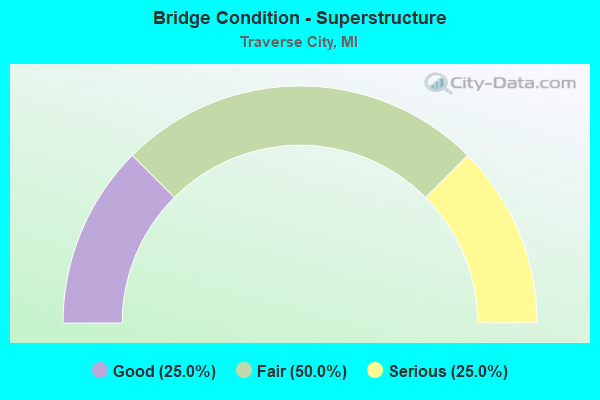
- Bridge Condition - Superstructure
- 25.0%Good
- 50.0%Fair
- 25.0%Serious

- Bridge Condition - Substructure
- 12.5%Very good
- 12.5%Good
- 37.5%Satisfactory
- 25.0%Fair
- 12.5%Poor
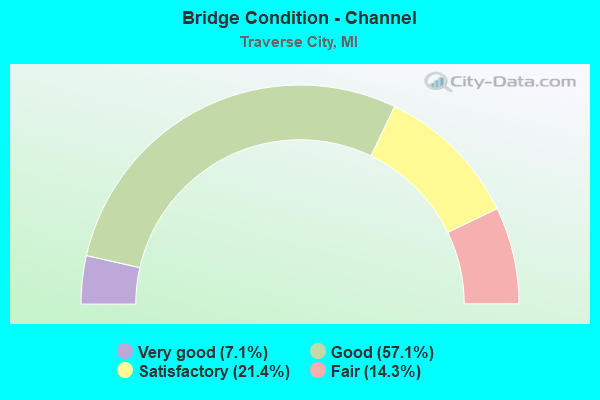
- Bridge Condition - Channel
- 7.1%Very good
- 57.1%Good
- 21.4%Satisfactory
- 14.3%Fair
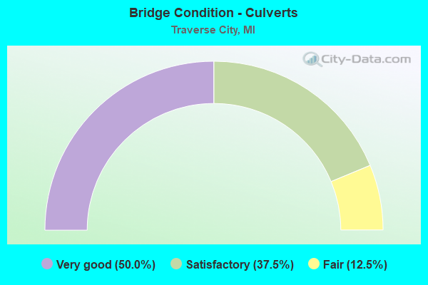
- Bridge Condition - Culverts
- 50.0%Very good
- 37.5%Satisfactory
- 12.5%Fair
Find on map >> Show street view
Structure Number: 3049, Location: IN TRAVERSE CITY (Lat: 44.764758, Lng: -85.612797), Route carried "on" structure: US 31, Year Built: 1951, Status: Open, Structure Length: 2.38m (7.81ft), Average Daily Traffic: 26,650 (year 2015), Truck Traffic: 2%, Average Future Daily Traffic: 29,750 (year 2037), Design Load: HS 20, Features Intersected: BOARDMAN RIVER
Minimum Vertical Clearance: 30.48m (100.00ft), Kilometerpoint: 2.713, Lanes on structure: 4, Base Highway Network: Yes (Inventory Route: 99, Subroute: 9), Owner: State Highway Agency, Approaching Roadway Width: 15.1m (49.5ft), Skew: 22 degrees, Material/Design: Steel, Design/Construction: Stringer/Multi-beam, Number Of Spans In Main Unit: 1, Length of Maximum Span: 23.2m (76.1ft), Curb or Sidewalk Widths: Left: 3.8m (12.5ft), Right: 1.7m (5.6ft), Curb-To-Curb Width: 15.2m (49.9ft), Out-to-Out Width: 25.1m (82.3ft)
Condition: Deck: Good, Superstructure: Good, Substructure: Very good, Channel: Very good, Operating Rating: 65.4 metric tons, Method Used To Determine Operating Rating: Load Factor (LF) rating reported by rating factor (RF) method using MS18 loading, Inventory Rating: 39.2 metric tons, Method Used To Determine Inventory Rating: Load Factor (LF) rating reported by rating factor (RF) method using MS18 loading, Structural Evaluation: Better than present minimum criteria, Deck Geometry: High priority of corrective action, Waterway Adequacy: Better than present minimum criteria, Approach Roadway Alignment: Equal to present desirable criteria, Designated Inspection Frequency: Every 24 months, Inspection Date: June 2020, Deck Structure Type: Concrete Cast-file-Place, Wearing Surface/Protective System: Wearing Surface: Latex Concrete, Deck Protection: Other
Find on map >> Show street view
Structure Number: 305, Location: IN ACME (Lat: 44.775472, Lng: -85.498797), Route carried "on" structure: US 31, Year Built: 1928, Year Reconstructed: 1986, Status: Open, Structure Length: 0.73m (2.40ft), Average Daily Traffic: 12,363 (year 2007), Truck Traffic: 3%, Average Future Daily Traffic: 13,271 (year 2018), Design Load: H 15, Features Intersected: ACME CREEK
Minimum Vertical Clearance: 30.48m (100.00ft), Kilometerpoint: 9.389, Lanes on structure: 5, Base Highway Network: Yes (Inventory Route: 99, Subroute: 2), Owner: State Highway Agency, Approaching Roadway Width: 16.8m (55.1ft), Skew: 4 degrees, Material/Design: Prestressed concrete, Design/Construction: Box Beam or Girders - Multiple, Number Of Spans In Main Unit: 1, Length of Maximum Span: 7.3m (24.0ft), Curb-To-Curb Width: 16.8m (55.1ft), Out-to-Out Width: 25.3m (83.0ft)
Condition: Deck: Good, Superstructure: Good, Substructure: Fair, Channel: Fair, Operating Rating: 71.9 metric tons, Method Used To Determine Operating Rating: Load Factor (LF) rating reported by rating factor (RF) method using MS18 loading, Inventory Rating: 43.1 metric tons, Method Used To Determine Inventory Rating: Load Factor (LF) rating reported by rating factor (RF) method using MS18 loading, Structural Evaluation: Somewhat better than minimum adequacy, Deck Geometry: High priority of replacement, Waterway Adequacy: Equal to present minimum criteria, Approach Roadway Alignment: Equal to present desirable criteria, Length Of Structure Improvement: 0.73m (2.40ft), Designated Inspection Frequency: Every 24 months, Inspection Date: June 2020, Bridge Improvement Cost: $7,000, Roadway Improvement Cost: $1,000, Total Project Cost: $8,000, Deck Structure Type: Concrete Cast-file-Place, Wearing Surface/Protective System: Deck Protection: Epoxy Coated Reinforcing
Find on map >> Show street view
Structure Number: 3051, Location: @ 3 MILE RD(E OF TR CITY) (Lat: 44.749497, Lng: -85.560183), Route carried "on" structure: US 31, Year Built: 1956, Status: Open, Structure Length: 0.61m (2.00ft), Average Daily Traffic: 29,516 (year 2007), Truck Traffic: 3%, Average Future Daily Traffic: 29,647 (year 2018), Design Load: HS 20+Mod, Features Intersected: MITCHELL CREEK
Minimum Vertical Clearance: 30.48m (100.00ft), Kilometerpoint: 2.747, Lanes on structure: 4, Base Highway Network: Yes (Inventory Route: 99, Subroute: 2), Owner: State Highway Agency, Approaching Roadway Width: 17.7m (58.1ft), Material/Design: Concrete, Design/Construction: Culvert, Number Of Spans In Main Unit: 2, Length of Maximum Span: 3.0m (9.8ft), Out-to-Out Width: 31.7m (104.0ft)
Condition: Channel: Fair, Culverts: Fair, Operating Rating: 56.4 metric tons, Method Used To Determine Operating Rating: Load Factor (LF) rating reported by rating factor (RF) method using MS18 loading, Inventory Rating: 33.7 metric tons, Method Used To Determine Inventory Rating: Load Factor (LF) rating reported by rating factor (RF) method using MS18 loading, Structural Evaluation: Somewhat better than minimum adequacy, Waterway Adequacy: Better than present minimum criteria, Approach Roadway Alignment: Equal to present minimum criteria, Designated Inspection Frequency: Every 24 months, Inspection Date: June 2021
Find on map >> Show street view
Structure Number: 3066, Location: 0.8 MI S OF TRAVERSE CITY (Lat: 44.733225, Lng: -85.616378), Route carried "on" structure: County highway 2020, Year Built: 1961, Status: Open, Structure Length: 1.18m (3.87ft), Average Daily Traffic: 18,938 (year 2019), Truck Traffic: 3%, Average Future Daily Traffic: 25,000 (year 2030), Design Load: HS 20+Mod, Features Intersected: BOARDMAN RIVER, Facility Carried by Structure: S AIRPORT ROAD
Minimum Vertical Clearance: 30.48m (100.00ft), Kilometerpoint: 1.468, Lanes on structure: 2, Owner: County Highway Agency, Approaching Roadway Width: 11.9m (39.0ft), Material/Design: Steel, Design/Construction: Culvert, Number Of Spans In Main Unit: 2, Length of Maximum Span: 4.7m (15.4ft), Curb-To-Curb Width: 9.8m (32.2ft), Out-to-Out Width: 10.0m (32.8ft)
Condition: Channel: Satisfactory, Culverts: Satisfactory, Operating Rating: 40.5 metric tons, Method Used To Determine Operating Rating: Load and Resistance Factor Rating (LRFR) rating reported by rating factor(RF) method using HL-93 loadings, Inventory Rating: 37.3 metric tons, Method Used To Determine Inventory Rating: Load and Resistance Factor Rating (LRFR) rating reported by rating factor(RF) method using HL-93 loadings, Structural Evaluation: Equal to present minimum criteria, Deck Geometry: Meets minimum limits, Waterway Adequacy: Equal to present minimum criteria, Approach Roadway Alignment: Equal to present desirable criteria, Designated Inspection Frequency: Every 24 months, Inspection Date: September 2020
Find on map >> Show street view
Structure Number: 3067, Location: 0.8 MI S OF TRAVERSE CITY (Lat: 44.733369, Lng: -85.612681), Route carried "on" structure: County highway 2020, Year Built: 1977, Status: Open, Structure Length: 1.25m (4.10ft), Average Daily Traffic: 21,860 (year 2019), Truck Traffic: 3%, Average Future Daily Traffic: 25,000 (year 2030), Design Load: HS 20+Mod, Features Intersected: BOARDMAN RIVER, Facility Carried by Structure: S AIRPORT ROAD
Minimum Vertical Clearance: 30.48m (100.00ft), Kilometerpoint: 1.704, Lanes on structure: 2, Owner: County Highway Agency, Approaching Roadway Width: 11.9m (39.0ft), Material/Design: Steel, Design/Construction: Culvert, Number Of Spans In Main Unit: 2, Length of Maximum Span: 4.7m (15.4ft), Curb-To-Curb Width: 9.8m (32.2ft), Out-to-Out Width: 10.0m (32.8ft)
Condition: Channel: Satisfactory, Culverts: Satisfactory, Operating Rating: 40.5 metric tons, Method Used To Determine Operating Rating: Load and Resistance Factor Rating (LRFR) rating reported by rating factor(RF) method using HL-93 loadings, Inventory Rating: 37.3 metric tons, Method Used To Determine Inventory Rating: Load and Resistance Factor Rating (LRFR) rating reported by rating factor(RF) method using HL-93 loadings, Structural Evaluation: Equal to present minimum criteria, Deck Geometry: Meets minimum limits, Waterway Adequacy: Equal to present minimum criteria, Approach Roadway Alignment: Equal to present desirable criteria, Designated Inspection Frequency: Every 24 months, Inspection Date: September 2020
Find on map >> Show street view
Structure Number: 3071, Location: IN TRAVERSE CITY (Lat: 44.759383, Lng: -85.616447), Route carried "on" structure: City street 2020, Year Built: 1974, Status: Open, Structure Length: 3.65m (11.98ft), Average Daily Traffic: 17,702 (year 2020), Truck Traffic: 6%, Average Future Daily Traffic: 21,600 (year 2040), Design Load: HS 20+Mod, Features Intersected: BOARDMAN RIVER, Facility Carried by Structure: EIGHTH STREET
Minimum Vertical Clearance: 30.48m (100.00ft), Kilometerpoint: 1.442, Lanes on structure: 4, Owner: City or Municipal Highway Agency, Approaching Roadway Width: 15.5m (50.9ft), Skew: 3 degrees, Material/Design: Prestressed concrete, Design/Construction: Box Beam or Girders - Multiple, Number Of Spans In Main Unit: 2, Length of Maximum Span: 18.2m (59.7ft), Curb or Sidewalk Widths: Left: 1.8m (5.9ft), Right: 1.8m (5.9ft), Curb-To-Curb Width: 15.5m (50.9ft), Out-to-Out Width: 20.6m (67.6ft)
Condition: Deck: Fair, Superstructure: Fair, Substructure: Satisfactory, Channel: Good, Operating Rating: 59.3 metric tons, Method Used To Determine Operating Rating: Load Factor (LF) rating reported by rating factor (RF) method using MS18 loading, Inventory Rating: 35.6 metric tons, Method Used To Determine Inventory Rating: Load Factor (LF) rating reported by rating factor (RF) method using MS18 loading, Structural Evaluation: Somewhat better than minimum adequacy, Deck Geometry: Meets minimum limits, Waterway Adequacy: Equal to present desirable criteria, Approach Roadway Alignment: Equal to present desirable criteria, Designated Inspection Frequency: Every 24 months, Inspection Date: May 2021, Deck Structure Type: Concrete Precast Panels, Wearing Surface/Protective System: Wearing Surface: Bituminous, Membrane: Other
Find on map >> Show street view
Structure Number: 3072, Location: IN TRAVERSE CITY (Lat: 44.764047, Lng: -85.627256), Route carried "on" structure: City street 2020, Year Built: 1904, Status: Open, Structure Length: 2.01m (6.59ft), Average Daily Traffic: 10,649 (year 2018), Truck Traffic: 19%, Average Future Daily Traffic: 19,233 (year 2038), Features Intersected: BOARDMAN RIVER, Facility Carried by Structure: FRONT STREET
Minimum Vertical Clearance: 30.48m (100.00ft), Kilometerpoint: 5.023, Lanes on structure: 2, Owner: City or Municipal Highway Agency, Approaching Roadway Width: 13.4m (44.0ft), Skew: 3 degrees, Material/Design: Concrete, Design/Construction: Arch - Deck, Number Of Spans In Main Unit: 1, Length of Maximum Span: 18.2m (59.7ft), Curb or Sidewalk Widths: Left: 2.9m (9.5ft), Right: 2.8m (9.2ft), Curb-To-Curb Width: 13.4m (44.0ft), Out-to-Out Width: 20.0m (65.6ft)
Condition: Superstructure: Serious, Substructure: Fair, Channel: Satisfactory, Operating Rating: 49.0 metric tons, Method Used To Determine Operating Rating: Load Testing, Inventory Rating: 32.7 metric tons, Method Used To Determine Inventory Rating: Load Testing, Structural Evaluation: High priority of corrective action, Deck Geometry: Equal to present minimum criteria, Waterway Adequacy: Better than present minimum criteria, Approach Roadway Alignment: Equal to present desirable criteria, Length Of Structure Improvement: 2.01m (6.59ft), Designated Inspection Frequency: Every 15 months, Inspection Date: May 2021, Bridge Improvement Cost: $451,000, Roadway Improvement Cost: $6,000, Total Project Cost: $469,000
Find on map >> Show street view
Structure Number: 3073, Location: IN TRAVERSE CITY (Lat: 44.764647, Lng: -85.618200), Route carried "on" structure: City street 2020, Year Built: 1956, Year Reconstructed: 2021, Status: Open, Structure Length: 1.83m (6.00ft), Average Daily Traffic: 3,824 (year 2020), Truck Traffic: 8%, Average Future Daily Traffic: 7,327 (year 2043), Design Load: Greater than HL93, Features Intersected: BOARDMAN RIVER, Facility Carried by Structure: PARK STREET
Minimum Vertical Clearance: 30.48m (100.00ft), Kilometerpoint: 0.195, Lanes on structure: 3, Owner: City or Municipal Highway Agency, Approaching Roadway Width: 10.4m (34.1ft), Material/Design: Steel, Design/Construction: Stringer/Multi-beam, Number Of Spans In Main Unit: 1, Length of Maximum Span: 17.5m (57.4ft), Curb or Sidewalk Widths: Left: 2.5m (8.2ft), Right: 2.5m (8.2ft), Curb-To-Curb Width: 10.4m (34.1ft), Out-to-Out Width: 16.1m (52.8ft)
Condition: Deck: Excellent, Superstructure: Fair, Substructure: Satisfactory, Channel: Good, Operating Rating: 48.9 metric tons, Method Used To Determine Operating Rating: Load and Resistance Factor Rating (LRFR) rating reported by rating factor(RF) method using HL-93 loadings, Inventory Rating: 37.6 metric tons, Method Used To Determine Inventory Rating: Load and Resistance Factor Rating (LRFR) rating reported by rating factor(RF) method using HL-93 loadings, Structural Evaluation: Somewhat better than minimum adequacy, Deck Geometry: High priority of replacement, Waterway Adequacy: Equal to present desirable criteria, Approach Roadway Alignment: Equal to present desirable criteria, Designated Inspection Frequency: Every 24 months, Inspection Date: November 2021, Deck Structure Type: Concrete Cast-file-Place, Wearing Surface/Protective System: Deck Protection: Epoxy Coated Reinforcing
Find on map >> Show street view
Structure Number: 3074, Location: IN TRAVERSE CITY (Lat: 44.762103, Lng: -85.623797), Route carried "on" structure: City street 2020, Year Built: 1931, Status: Open, Structure Length: 2.28m (7.48ft), Average Daily Traffic: 6,843 (year 2018), Truck Traffic: 8%, Average Future Daily Traffic: 12,359 (year 2038), Design Load: HS 20+Mod, Features Intersected: BOARDMAN RIVER, Facility Carried by Structure: UNION STREET-SOUTH
Minimum Vertical Clearance: 30.48m (100.00ft), Kilometerpoint: 1.777, Lanes on structure: 2, Owner: City or Municipal Highway Agency, Approaching Roadway Width: 12.2m (40.0ft), Skew: 1 degrees, Material/Design: Steel, Design/Construction: Stringer/Multi-beam, Number Of Spans In Main Unit: 1, Length of Maximum Span: 22.2m (72.8ft), Curb or Sidewalk Widths: Left: 2.4m (7.9ft), Right: 2.4m (7.9ft), Curb-To-Curb Width: 12.2m (40.0ft), Out-to-Out Width: 18.1m (59.4ft)
Condition: Deck: Poor, Superstructure: Fair, Substructure: Satisfactory, Channel: Good, Operating Rating: 62.5 metric tons, Method Used To Determine Operating Rating: Load Factor (LF) rating reported by rating factor (RF) method using MS18 loading, Inventory Rating: 37.6 metric tons, Method Used To Determine Inventory Rating: Load Factor (LF) rating reported by rating factor (RF) method using MS18 loading, Structural Evaluation: Somewhat better than minimum adequacy, Deck Geometry: Somewhat better than minimum adequacy, Waterway Adequacy: Equal to present desirable criteria, Approach Roadway Alignment: Equal to present desirable criteria, Length Of Structure Improvement: 2.29m (7.51ft), Designated Inspection Frequency: Every 24 months, Inspection Date: May 2021, Bridge Improvement Cost: $800,000,000, Roadway Improvement Cost: $145,000,000, Total Project Cost: $945,000,000 ( Estimate for 2020), Deck Structure Type: Concrete Cast-file-Place, Wearing Surface/Protective System: Wearing Surface: Bituminous, Membrane: Other
Find on map >> Show street view
Structure Number: 3076, Location: IN TRAVERSE CITY (Lat: 44.761083, Lng: -85.620989), Route carried "on" structure: City street 2020, Year Built: 1930, Status: Posted for load, Structure Length: 2.07m (6.79ft), Average Daily Traffic: 9,710 (year 2012), Truck Traffic: 11%, Average Future Daily Traffic: 11,000 (year 2023), Design Load: HS 20+Mod, Features Intersected: BOARDMAN RIVER, Facility Carried by Structure: SOUTH CASS STREET
Minimum Vertical Clearance: 30.48m (100.00ft), Kilometerpoint: 7.662, Lanes on structure: 2, Owner: City or Municipal Highway Agency, Approaching Roadway Width: 12.2m (40.0ft), Material/Design: Concrete, Design/Construction: Arch - Deck, Number Of Spans In Main Unit: 1, Length of Maximum Span: 20.7m (67.9ft), Curb or Sidewalk Widths: Left: 2.4m (7.9ft), Right: 2.3m (7.5ft), Curb-To-Curb Width: 12.2m (40.0ft), Out-to-Out Width: 17.8m (58.4ft)
Condition: Superstructure: Serious, Substructure: Poor, Channel: Good, Operating Rating: 30.8 metric tons, Method Used To Determine Operating Rating: Load Factor (LF), Inventory Rating: 17.6 metric tons, Method Used To Determine Inventory Rating: Load Factor (LF), Structural Evaluation: High priority of corrective action, Deck Geometry: Somewhat better than minimum adequacy, Waterway Adequacy: Equal to present desirable criteria, Approach Roadway Alignment: Equal to present desirable criteria, Bridge Posting: Required (Relationship of Operating Rating to Maximum Legal Load: 30.0 - 39.9% below), Length Of Structure Improvement: 3.66m (12.01ft), Designated Inspection Frequency: Every 12 months, Inspection Date: May 2021, Bridge Improvement Cost: $504,000, Roadway Improvement Cost: $50,000, Total Project Cost: $594,000
Find on map >> Show street view
Structure Number: 3077, Location: IN TRAVERSE CITY (Lat: 44.764803, Lng: -85.621003), Route carried "on" structure: City street 2020, Year Built: 1960, Status: Open, Structure Length: 1.82m (5.97ft), Average Daily Traffic: 4,474 (year 2016), Truck Traffic: 8%, Average Future Daily Traffic: 5,000 (year 2036), Design Load: HS 20+Mod, Features Intersected: BOARDMAN RIVER, Facility Carried by Structure: NORTH CASS STREET
Minimum Vertical Clearance: 30+ m (98+ ft), Kilometerpoint: 8.031, Lanes on structure: 2, Owner: City or Municipal Highway Agency, Approaching Roadway Width: 7.6m (24.9ft), Material/Design: Prestressed concrete, Design/Construction: Box Beam or Girders - Multiple, Number Of Spans In Main Unit: 1, Length of Maximum Span: 18.2m (59.7ft), Curb or Sidewalk Widths: Left: 1.5m (4.9ft), Right: 1.5m (4.9ft), Curb-To-Curb Width: 7.3m (24.0ft), Out-to-Out Width: 11.2m (36.7ft)
Condition: Deck: Fair, Superstructure: Fair, Substructure: Good, Channel: Good, Operating Rating: 54.4 metric tons, Method Used To Determine Operating Rating: Load Factor (LF) rating reported by rating factor (RF) method using MS18 loading, Inventory Rating: 32.7 metric tons, Method Used To Determine Inventory Rating: Load Factor (LF) rating reported by rating factor (RF) method using MS18 loading, Structural Evaluation: Somewhat better than minimum adequacy, Deck Geometry: High priority of replacement, Waterway Adequacy: Equal to present desirable criteria, Approach Roadway Alignment: Equal to present minimum criteria, Designated Inspection Frequency: Every 24 months, Inspection Date: May 2021, Deck Structure Type: Concrete Precast Panels, Wearing Surface/Protective System: Wearing Surface: Bituminous, Membrane: Preformed Fabric
Find on map >> Show street view
Structure Number: 13287, Location: 0.5 MI E OF TRAVERSE CITY (Lat: 44.741131, Lng: -85.551589), Route carried "on" structure: Business County highway , Year Built: 2001, Status: Open, Structure Length: 1.03m (3.38ft), Average Daily Traffic: 988 (year 2019), Truck Traffic: 21%, Average Future Daily Traffic: 1,100 (year 2030), Design Load: HS 20, Features Intersected: MITCHELL CREEK, Facility Carried by Structure: BUSINESS PARK DRV
Minimum Vertical Clearance: 30.48m (100.00ft), Kilometerpoint: 0.055, Lanes on structure: 2, Owner: County Highway Agency, Approaching Roadway Width: 10.1m (33.1ft), Material/Design: Concrete, Design/Construction: Culvert, Number Of Spans In Main Unit: 1, Length of Maximum Span: 10.3m (33.8ft), Curb-To-Curb Width: 10.1m (33.1ft), Out-to-Out Width: 11.4m (37.4ft)
Condition: Channel: Good, Culverts: Satisfactory, Operating Rating: 54.5 metric tons, Method Used To Determine Operating Rating: Field evaluation and documented engineering judgment, Inventory Rating: 32.7 metric tons, Method Used To Determine Inventory Rating: Field evaluation and documented engineering judgment, Structural Evaluation: Equal to present minimum criteria, Deck Geometry: Equal to present minimum criteria, Waterway Adequacy: Equal to present desirable criteria, Approach Roadway Alignment: Equal to present desirable criteria, Designated Inspection Frequency: Every 24 months, Inspection Date: September 2020, Wearing Surface/Protective System: Wearing Surface: Bituminous
Find on map >> Show street view
Structure Number: 13359, Location: 1.07 MI S OF US-31 (Lat: 44.734911, Lng: -85.556350), Route carried "on" structure: County highway , Year Built: 2005, Status: Open, Structure Length: 1.04m (3.41ft), Average Daily Traffic: 9,668 (year 2019), Truck Traffic: 25%, Average Future Daily Traffic: 12,000 (year 2030), Design Load: HS 20, Features Intersected: MITCHELL CREEK, Facility Carried by Structure: THREE MILE ROAD
Minimum Vertical Clearance: 30.48m (100.00ft), Kilometerpoint: 7.435, Lanes on structure: 5, Owner: County Highway Agency, Approaching Roadway Width: 22.2m (72.8ft), Skew: 1 degrees, Material/Design: Concrete, Design/Construction: Culvert, Number Of Spans In Main Unit: 1, Length of Maximum Span: 9.8m (32.2ft), Curb-To-Curb Width: 19.2m (63.0ft), Out-to-Out Width: 30.5m (100.1ft)
Condition: Channel: Good, Culverts: Very good, Operating Rating: 41.9 metric tons, Method Used To Determine Operating Rating: Field evaluation and documented engineering judgment, Inventory Rating: 32.7 metric tons, Method Used To Determine Inventory Rating: Field evaluation and documented engineering judgment, Structural Evaluation: Equal to present desirable criteria, Deck Geometry: Meets minimum limits, Waterway Adequacy: Equal to present desirable criteria, Approach Roadway Alignment: Equal to present desirable criteria, Designated Inspection Frequency: Every 24 months, Inspection Date: September 2020, Wearing Surface/Protective System: Wearing Surface: Bituminous
Find on map >> Show street view
Structure Number: 1336, Location: .07 MI S OF US-31 (Lat: 44.748183, Lng: -85.558572), Route carried "on" structure: County highway , Year Built: 2006, Status: Open, Structure Length: 0.69m (2.26ft), Average Daily Traffic: 24,586 (year 2019), Truck Traffic: 25%, Average Future Daily Traffic: 38,300 (year 2026), Design Load: HS 20, Features Intersected: MITCHELL CREEK, Facility Carried by Structure: THREE MILE ROAD
Minimum Vertical Clearance: 30.48m (100.00ft), Kilometerpoint: 9.035, Lanes on structure: 5, Owner: County Highway Agency, Approaching Roadway Width: 22.2m (72.8ft), Skew: 1 degrees, Material/Design: Concrete, Design/Construction: Culvert, Number Of Spans In Main Unit: 1, Length of Maximum Span: 6.3m (20.7ft), Curb or Sidewalk Widths: Left: 5.3m (17.4ft), Right: 0.0m, Curb-To-Curb Width: 19.2m (63.0ft), Out-to-Out Width: 26.5m (86.9ft)
Condition: Channel: Good, Culverts: Very good, Operating Rating: 41.9 metric tons, Method Used To Determine Operating Rating: Field evaluation and documented engineering judgment, Inventory Rating: 32.7 metric tons, Method Used To Determine Inventory Rating: Field evaluation and documented engineering judgment, Structural Evaluation: Equal to present desirable criteria, Deck Geometry: Meets minimum limits, Waterway Adequacy: Equal to present desirable criteria, Approach Roadway Alignment: Equal to present desirable criteria, Designated Inspection Frequency: Every 24 months, Inspection Date: September 2020, Wearing Surface/Protective System: Wearing Surface: Bituminous
Find on map >> Show street view
Structure Number: 13602, Location: 0.9 MI W OF GARFIELD RD (Lat: 44.715406, Lng: -85.614394), Route carried "on" structure: County highway 660, Year Built: 2009, Status: Open, Structure Length: 0.91m (2.99ft), Average Daily Traffic: 15,578 (year 2019), Truck Traffic: 24%, Average Future Daily Traffic: 28,750 (year 2031), Features Intersected: GLC RR, Facility Carried by Structure: HAMMOND ROAD
Minimum Vertical Clearance: 30.48m (100.00ft), Kilometerpoint: 0.021, Lanes on structure: 4, Owner: County Highway Agency, Approaching Roadway Width: 15.2m (49.9ft), Material/Design: Concrete, Design/Construction: Culvert, Number Of Spans In Main Unit: 1, Length of Maximum Span: 8.5m (27.9ft), Curb-To-Curb Width: 14.6m (47.9ft), Out-to-Out Width: 36.6m (120.1ft)
Condition: Culverts: Very good, Operating Rating: 32.7 metric tons, Method Used To Determine Operating Rating: Field evaluation and documented engineering judgment, Inventory Rating: 19.6 metric tons, Method Used To Determine Inventory Rating: Field evaluation and documented engineering judgment, Structural Evaluation: Meets minimum limits, Deck Geometry: High priority of replacement, Underclear: Equal to present minimum criteria, Approach Roadway Alignment: Equal to present desirable criteria, Designated Inspection Frequency: Every 24 months, Inspection Date: September 2020, Wearing Surface/Protective System: Wearing Surface: Bituminous
Find on map >> Show street view
Structure Number: 13603, Location: 0.1 MI N OF HAMMOND ROAD (Lat: 44.717744, Lng: -85.614044), Route carried "on" structure: County highway , Year Built: 2009, Status: Open, Structure Length: 2.10m (6.89ft), Average Daily Traffic: 5,348 (year 2019), Truck Traffic: 13%, Average Future Daily Traffic: 12,650 (year 2028), Features Intersected: GLC RR, Facility Carried by Structure: KEYSTONE ROAD N
Minimum Vertical Clearance: 30.48m (100.00ft), Kilometerpoint: 4.556, Lanes on structure: 2, Owner: County Highway Agency, Approaching Roadway Width: 11.0m (36.1ft), Skew: 6 degrees, Material/Design: Concrete, Design/Construction: Culvert, Number Of Spans In Main Unit: 1, Length of Maximum Span: 19.8m (65.0ft), Curb-To-Curb Width: 11.6m (38.1ft), Out-to-Out Width: 82.3m (270.0ft)
Condition: Culverts: Very good, Operating Rating: 32.7 metric tons, Method Used To Determine Operating Rating: Field evaluation and documented engineering judgment, Inventory Rating: 19.6 metric tons, Method Used To Determine Inventory Rating: Field evaluation and documented engineering judgment, Structural Evaluation: Meets minimum limits, Deck Geometry: Somewhat better than minimum adequacy, Underclear: Equal to present minimum criteria, Approach Roadway Alignment: Better than present minimum criteria, Designated Inspection Frequency: Every 24 months, Inspection Date: September 2020, Wearing Surface/Protective System: Wearing Surface: Bituminous
Find on map >> Show street view
Structure Number: 3052, Location: TRAVERSE CITY STATE PARK (Lat: 44.747686, Lng: -85.551636), Route carried "under" structure: US 31, Year Built: 1966, Structure Length: 0. m, Average Daily Traffic: 38,324 (year 2007), Truck Traffic: 3%, Features Intersected: US-31, Facility Carried by Structure: TC STATE PARK PED
Minimum Vertical Clearance: 4.72m (15.49ft), Kilometerpoint: 3.454, Lanes under structure: 5, Material/Design: Steel, Design/Construction: Stringer/Multi-beam, Length of Maximum Span: 22.5m (73.8ft)