Bridge Statistics for Trafford, Pennsylvania (PA)
Condition, Traffic, Stress, Structural Evaluation, Project Costs
- National Bridge Inventory (NBI) Statistics
- 12Number of bridges
- 154ft / 47.2mTotal length
- $3,110,000Total costs
- 70,682Total average daily traffic
- 7,935Total average daily truck traffic
- 98,496Total future (year 2025) average daily traffic
- National Bridge Inventory (NBI) Registered Bridges for Trafford
- No street view available for this location
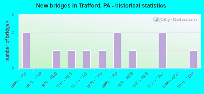
- New bridges - historical statistics
- 21900-1909
- 11920-1929
- 11930-1939
- 11940-1949
- 11950-1959
- 21960-1969
- 11970-1979
- 21990-1999
- 12010-2019

- Reconstructed bridges - Historical Statistics
- 21920-1929
- 01930-1939
- 01940-1949
- 01950-1959
- 01960-1969
- 01970-1979
- 01980-1989
- 31990-1999
- 02000-2009
- 12010-2019


- Bridge Condition - Deck
- 11.1%Very good
- 22.2%Good
- 33.3%Satisfactory
- 22.2%Fair
- 11.1%Poor

- Bridge Condition - Superstructure
- 11.1%Very good
- 11.1%Good
- 22.2%Satisfactory
- 33.3%Fair
- 22.2%Poor

- Bridge Condition - Substructure
- 22.2%Good
- 44.4%Satisfactory
- 33.3%Fair

- Bridge Condition - Channel
- 18.2%Good
- 18.2%Satisfactory
- 27.3%Fair
- 36.4%Poor

- Bridge Condition - Culverts
- 33.3%Good
- 66.7%Fair
Find on map >> Show street view
Structure Number: 2729, Location: 491001 TRAFFORD BOROUGH (Lat: 40.380328, Lng: -79.768542), Route carried "on" structure: City street , Year Built: 1994, Status: Open, Structure Length: 2.10m (6.89ft), Average Daily Traffic: 100 (year 2005), Truck Traffic: 5%, Average Future Daily Traffic: 110 (year 2025), Design Load: HS 25 or greater, Features Intersected: BRUSH CREEK, Facility Carried by Structure: WALLACE AV
Minimum Vertical Clearance: 30+ m (98+ ft), Kilometerpoint: 0.000, Lanes on structure: 2, Owner: City or Municipal Highway Agency, Approaching Roadway Width: 9.1m (29.9ft), Material/Design: Prestressed concrete, Design/Construction: Box Beam or Girders - Multiple, Number Of Spans In Main Unit: 1, Length of Maximum Span: 20.4m (66.9ft), Curb-To-Curb Width: 8.8m (28.9ft), Out-to-Out Width: 9.9m (32.5ft)
Condition: Deck: Fair, Superstructure: Poor, Substructure: Good, Channel: Poor, Operating Rating: 76.2 metric tons, Method Used To Determine Operating Rating: Load Factor (LF), Inventory Rating: 26.3 metric tons, Method Used To Determine Inventory Rating: Load Factor (LF), Structural Evaluation: Meets minimum limits, Deck Geometry: Better than present minimum criteria, Waterway Adequacy: Superior to present desirable criteria, Approach Roadway Alignment: Equal to present desirable criteria, Length Of Structure Improvement: 2.10m (6.89ft), Designated Inspection Frequency: Every 24 months, Inspection Date: November 2019, Deck Structure Type: Other, Wearing Surface/Protective System: Wearing Surface: Bituminous, Membrane: Preformed Fabric
Find on map >> Show street view
Structure Number: 9833, Location: .8 MI FROM SR 322 (Lat: 40.784269, Lng: -77.676536), Route carried "on" structure: ServiceCity street , Year Built: 1965, Year Reconstructed: 2004, Status: Open, Structure Length: 1.71m (5.61ft), Average Daily Traffic: 300 (year 2021), Average Future Daily Traffic: 375 (year 2043), Design Load: HS 20, Features Intersected: SINKING CREEK, Facility Carried by Structure: T-609 COLYER RD
Minimum Vertical Clearance: 30+ m (98+ ft), Kilometerpoint: 0.000, Lanes on structure: 2, Owner: Town or Township Highway Agency, Approaching Roadway Width: 5.5m (18.0ft), Material/Design: Steel, Design/Construction: Stringer/Multi-beam, Number Of Spans In Main Unit: 1, Length of Maximum Span: 16.8m (55.1ft), Curb-To-Curb Width: 6.5m (21.3ft), Out-to-Out Width: 6.6m (21.7ft)
Condition: Deck: Satisfactory, Superstructure: Fair, Substructure: Fair, Channel: Fair, Operating Rating: 82.6 metric tons, Method Used To Determine Operating Rating: Load Factor (LF), Inventory Rating: 49.0 metric tons, Method Used To Determine Inventory Rating: Load Factor (LF), Structural Evaluation: Somewhat better than minimum adequacy, Deck Geometry: Meets minimum limits, Waterway Adequacy: Better than present minimum criteria, Approach Roadway Alignment: Equal to present minimum criteria, Length Of Structure Improvement: 2.10m (6.89ft), Designated Inspection Frequency: Every 24 months, Inspection Date: April 2021, Bridge Improvement Cost: $62,000, Roadway Improvement Cost: $263,000, Total Project Cost: $835,000, Deck Structure Type: Concrete Cast-file-Place, Wearing Surface/Protective System: Wearing Surface: Monolithic Concrete, Deck Protection: Epoxy Coated Reinforcing
Find on map >> Show street view
Structure Number: 9834, Location: 1200 FT NE OF SR 144 (Lat: 40.805442, Lng: -77.624386), Route carried "on" structure: City street , Year Built: 1965, Year Reconstructed: 2003, Status: Posted for load, Structure Length: 1.31m (4.30ft), Average Daily Traffic: 350 (year 2021), Truck Traffic: 2%, Average Future Daily Traffic: 375 (year 2043), Design Load: HS 20, Features Intersected: POTTER RUN, Facility Carried by Structure: L GEORGES VLLY RD
Minimum Vertical Clearance: 30+ m (98+ ft), Kilometerpoint: 0.000, Lanes on structure: 1, Owner: Town or Township Highway Agency, Approaching Roadway Width: 5.5m (18.0ft), Skew: 3 degrees, Material/Design: Steel, Design/Construction: Stringer/Multi-beam, Number Of Spans In Main Unit: 1, Length of Maximum Span: 12.2m (40.0ft), Curb-To-Curb Width: 5.2m (17.1ft), Out-to-Out Width: 5.5m (18.0ft)
Condition: Deck: Good, Superstructure: Fair, Substructure: Satisfactory, Channel: Fair, Operating Rating: 41.7 metric tons, Method Used To Determine Operating Rating: Load Factor (LF), Inventory Rating: 24.5 metric tons, Method Used To Determine Inventory Rating: Load Factor (LF), Structural Evaluation: Somewhat better than minimum adequacy, Deck Geometry: High priority of replacement, Waterway Adequacy: Better than present minimum criteria, Approach Roadway Alignment: Equal to present desirable criteria, Bridge Posting: Required (Relationship of Operating Rating to Maximum Legal Load: 0.1 - 9.9% below), Length Of Structure Improvement: 1.60m (5.25ft), Designated Inspection Frequency: Every 24 months, Other Special Inspection Frequency: Every 12 months, Inspection Date: April 2021, Other Special Inspection Date: April 2021, Bridge Improvement Cost: $29,000, Roadway Improvement Cost: $264,000, Total Project Cost: $389,000, Deck Structure Type: Concrete Cast-file-Place, Wearing Surface/Protective System: Wearing Surface: Monolithic Concrete, Deck Protection: Epoxy Coated Reinforcing
Find on map >> Show street view
Structure Number: 28364, Location: 0.5 MI E WASHINGTONVILLE (Lat: 41.049944, Lng: -76.665142), Route carried "on" structure: State highway 254, Year Built: 1942, Status: Open, Structure Length: 0.64m (2.10ft), Average Daily Traffic: 2,657 (year 2021), Truck Traffic: 25%, Average Future Daily Traffic: 2,500 (year 2032), Features Intersected: OVER TRIB TO MUD CREEK
Minimum Vertical Clearance: 30+ m (98+ ft), Kilometerpoint: 8.723, Lanes on structure: 2, Owner: State Highway Agency, Approaching Roadway Width: 9.4m (30.8ft), Skew: 3 degrees, Material/Design: Concrete, Design/Construction: Slab, Number Of Spans In Main Unit: 1, Length of Maximum Span: 6.1m (20.0ft), Curb or Sidewalk Widths: Left: 0.2m (0.7ft), Right: 0.2m (0.7ft), Curb-To-Curb Width: 9.1m (29.9ft), Out-to-Out Width: 10.2m (33.5ft)
Condition: Deck: Satisfactory, Superstructure: Satisfactory, Substructure: Satisfactory, Channel: Poor, Operating Rating: 54.4 metric tons, Method Used To Determine Operating Rating: Field evaluation and documented engineering judgment, Inventory Rating: 32.7 metric tons, Method Used To Determine Inventory Rating: Field evaluation and documented engineering judgment, Structural Evaluation: Equal to present minimum criteria, Deck Geometry: Meets minimum limits, Waterway Adequacy: Equal to present minimum criteria, Approach Roadway Alignment: Equal to present desirable criteria, Length Of Structure Improvement: 3.70m (12.14ft), Designated Inspection Frequency: Every 24 months, Inspection Date: October 2020, Wearing Surface/Protective System: Wearing Surface: Bituminous, Membrane: Preformed Fabric
Find on map >> Show street view
Structure Number: 2852, Location: 1 MI.N.OF PA 512 (Lat: 40.848014, Lng: -75.302728), Route carried "on" structure: State highway 33, Year Built: 1958, Year Reconstructed: 1996, Status: Open, Structure Length: 1.46m (4.79ft), Average Daily Traffic: 37,369 (year 2021), Truck Traffic: 15%, Average Future Daily Traffic: 43,653 (year 2032), Design Load: H 20, Features Intersected: SR1026(CENTER ST/LR48088
Minimum Vertical Clearance: 30+ m (98+ ft), Kilometerpoint: 25.188, Lanes on structure: 4, Lanes under structure: 2, Base Highway Network: Yes, Owner: State Highway Agency, Approaching Roadway Width: 24.7m (81.0ft), Skew: 33 degrees, Material/Design: Concrete, Design/Construction: Tee Beam, Number Of Spans In Main Unit: 1, Length of Maximum Span: 13.7m (44.9ft), Curb-To-Curb Width: 24.7m (81.0ft), Out-to-Out Width: 26.7m (87.6ft)
Condition: Deck: Satisfactory, Superstructure: Satisfactory, Substructure: Satisfactory, Operating Rating: 71.7 metric tons, Method Used To Determine Operating Rating: Load Factor (LF), Inventory Rating: 42.6 metric tons, Method Used To Determine Inventory Rating: Load Factor (LF), Structural Evaluation: Equal to present minimum criteria, Deck Geometry: Superior to present desirable criteria, Underclear: Meets minimum limits, Approach Roadway Alignment: Equal to present desirable criteria, Length Of Structure Improvement: 2.10m (6.89ft), Designated Inspection Frequency: Every 24 months, Inspection Date: May 2020, Bridge Improvement Cost: $23,000, Roadway Improvement Cost: $67,000, Total Project Cost: $308,000, Deck Structure Type: Concrete Cast-file-Place, Wearing Surface/Protective System: Wearing Surface: Epoxy Overlay
Find on map >> Show street view
Structure Number: 33413, Location: 2.5 MI EAST OF VICKSBURG (Lat: 40.953000, Lng: -76.934614), Route carried "on" structure: State highway 45, Year Built: 1936, Status: Open, Structure Length: 0.64m (2.10ft), Average Daily Traffic: 11,006 (year 2021), Truck Traffic: 6%, Average Future Daily Traffic: 16,838 (year 2032), Features Intersected: OVER BR OF LIMESTONE RUN
Minimum Vertical Clearance: 30+ m (98+ ft), Kilometerpoint: 30.320, Lanes on structure: 2, Owner: State Highway Agency, Approaching Roadway Width: 10.1m (33.1ft), Skew: 1 degrees, Material/Design: Concrete, Design/Construction: Slab, Number Of Spans In Main Unit: 1, Length of Maximum Span: 6.1m (20.0ft), Curb or Sidewalk Widths: Left: 0.3m (1.0ft), Right: 0.3m (1.0ft), Curb-To-Curb Width: 12.0m (39.4ft), Out-to-Out Width: 13.1m (43.0ft)
Condition: Deck: Fair, Superstructure: Fair, Substructure: Fair, Channel: Poor, Operating Rating: 54.4 metric tons, Method Used To Determine Operating Rating: Field evaluation and documented engineering judgment, Inventory Rating: 32.7 metric tons, Method Used To Determine Inventory Rating: Field evaluation and documented engineering judgment, Structural Evaluation: Somewhat better than minimum adequacy, Deck Geometry: Somewhat better than minimum adequacy, Waterway Adequacy: Superior to present desirable criteria, Approach Roadway Alignment: Equal to present desirable criteria, Length Of Structure Improvement: 0.60m (1.97ft), Designated Inspection Frequency: Every 24 months, Inspection Date: Febuary 2021, Bridge Improvement Cost: $8,000, Roadway Improvement Cost: $50,000, Total Project Cost: $105,000, Wearing Surface/Protective System: Wearing Surface: Bituminous, Membrane: Preformed Fabric
Find on map >> Show street view
Structure Number: 36344, Location: NORTH HUNTINGDON TOWNSHIP (Lat: 40.372089, Lng: -79.757644), Route carried "on" structure: State highway 993, Year Built: 1901, Year Reconstructed: 1931, Status: Open, Structure Length: 2.07m (6.79ft), Average Daily Traffic: 2,759 (year 2020), Truck Traffic: 9%, Average Future Daily Traffic: 7,003 (year 2032), Design Load: HS 20+Mod, Features Intersected: BRUSH CREEK
Minimum Vertical Clearance: 30+ m (98+ ft), Kilometerpoint: 1.397, Lanes on structure: 2, Owner: State Highway Agency, Approaching Roadway Width: 11.6m (38.1ft), Material/Design: Masonry, Design/Construction: Culvert, Number Of Spans In Main Unit: 2, Length of Maximum Span: 9.8m (32.2ft)
Condition: Channel: Poor, Culverts: Fair, Inventory Rating: 99.8 metric tons, Method Used To Determine Inventory Rating: Load Factor (LF), Structural Evaluation: Somewhat better than minimum adequacy, Waterway Adequacy: Superior to present desirable criteria, Approach Roadway Alignment: Equal to present desirable criteria, Length Of Structure Improvement: 2.10m (6.89ft), Designated Inspection Frequency: Every 24 months, Inspection Date: April 2021, Bridge Improvement Cost: $42,000, Roadway Improvement Cost: $200,000, Total Project Cost: $568,000
Find on map >> Show street view
Structure Number: 36345, Location: NORTH HUNTINGDON TOWNSHIP (Lat: 40.369394, Lng: -79.748986), Route carried "on" structure: State highway 993, Year Built: 1901, Year Reconstructed: 1931, Status: Open, Structure Length: 1.95m (6.40ft), Average Daily Traffic: 2,759 (year 2020), Truck Traffic: 9%, Average Future Daily Traffic: 7,003 (year 2032), Design Load: H 20, Features Intersected: BRUSH CREEK
Minimum Vertical Clearance: 30+ m (98+ ft), Kilometerpoint: 2.168, Lanes on structure: 2, Owner: State Highway Agency, Approaching Roadway Width: 11.6m (38.1ft), Material/Design: Masonry, Design/Construction: Culvert, Number Of Spans In Main Unit: 2, Length of Maximum Span: 7.9m (25.9ft)
Condition: Channel: Fair, Culverts: Fair, Inventory Rating: 99.8 metric tons, Method Used To Determine Inventory Rating: Load Factor (LF), Structural Evaluation: Somewhat better than minimum adequacy, Waterway Adequacy: Superior to present desirable criteria, Approach Roadway Alignment: Equal to present desirable criteria, Length Of Structure Improvement: 1.70m (5.58ft), Designated Inspection Frequency: Every 24 months, Inspection Date: April 2021, Bridge Improvement Cost: $38,000, Roadway Improvement Cost: $200,000, Total Project Cost: $515,000
Find on map >> Show street view
Structure Number: 36695, Location: TRAFFORD BOROUGH (Lat: 40.389047, Lng: -79.750703), Route carried "on" structure: State highway , Year Built: 1925, Year Reconstructed: 2010, Status: Open, Structure Length: 2.23m (7.32ft), Average Daily Traffic: 5,658 (year 2022), Truck Traffic: 5%, Average Future Daily Traffic: 8,696 (year 2032), Design Load: HL 93, Features Intersected: TURTLE CREEK, Facility Carried by Structure: SR 4018
Minimum Vertical Clearance: 30+ m (98+ ft), Kilometerpoint: 0.000, Lanes on structure: 2, Owner: State Highway Agency, Approaching Roadway Width: 6.1m (20.0ft), Material/Design: Steel, Design/Construction: Stringer/Multi-beam, Number Of Spans In Main Unit: 1, Length of Maximum Span: 21.9m (71.9ft), Curb or Sidewalk Widths: Left: 0.1m (0.3ft), Right: 0.1m (0.3ft), Curb-To-Curb Width: 8.5m (27.9ft), Out-to-Out Width: 9.6m (31.5ft)
Condition: Deck: Very good, Superstructure: Very good, Substructure: Satisfactory, Channel: Good, Operating Rating: 71.7 metric tons, Method Used To Determine Operating Rating: Load and Resistance Factor (LRFR), Inventory Rating: 55.3 metric tons, Method Used To Determine Inventory Rating: Load and Resistance Factor (LRFR), Structural Evaluation: Equal to present minimum criteria, Deck Geometry: High priority of replacement, Waterway Adequacy: Superior to present desirable criteria, Approach Roadway Alignment: Equal to present desirable criteria, Length Of Structure Improvement: 3.00m (9.84ft), Designated Inspection Frequency: Every 24 months, Inspection Date: Febuary 2020, Bridge Improvement Cost: $29,000, Roadway Improvement Cost: $85,000, Total Project Cost: $390,000, Deck Structure Type: Concrete Cast-file-Place, Wearing Surface/Protective System: Wearing Surface: Monolithic Concrete, Deck Protection: Epoxy Coated Reinforcing
Find on map >> Show street view
Structure Number: 36869, Location: 1/2 MI SW OF SR 993 (Lat: 40.371506, Lng: -79.762597), Route carried "on" structure: City street , Year Built: 1978, Status: Posted for load, Structure Length: 3.08m (10.10ft), Average Daily Traffic: 500 (year 2012), Truck Traffic: 1%, Average Future Daily Traffic: 640 (year 2031), Design Load: HS 20, Features Intersected: BRUSH CREEK, Facility Carried by Structure: MAHAFFEY HILL ROAD
Minimum Vertical Clearance: 30+ m (98+ ft), Kilometerpoint: 0.000, Lanes on structure: 2, Base Highway Network: Yes, Owner: County Highway Agency, Approaching Roadway Width: 6.1m (20.0ft), Material/Design: Prestressed concrete, Design/Construction: Box Beam or Girders - Multiple, Number Of Spans In Main Unit: 2, Length of Maximum Span: 14.9m (48.9ft), Curb or Sidewalk Widths: Left: 0.2m (0.7ft), Right: 0.2m (0.7ft), Curb-To-Curb Width: 8.0m (26.2ft), Out-to-Out Width: 9.0m (29.5ft)
Condition: Deck: Poor, Superstructure: Poor, Substructure: Fair, Channel: Satisfactory, Operating Rating: 38.1 metric tons, Method Used To Determine Operating Rating: Load Factor (LF), Inventory Rating: 16.3 metric tons, Method Used To Determine Inventory Rating: Load Factor (LF), Structural Evaluation: Meets minimum limits, Deck Geometry: Somewhat better than minimum adequacy, Waterway Adequacy: Equal to present desirable criteria, Approach Roadway Alignment: Equal to present desirable criteria, Bridge Posting: Required (Relationship of Operating Rating to Maximum Legal Load: 0.1 - 9.9% below), Length Of Structure Improvement: 3.80m (12.47ft), Designated Inspection Frequency: Every 24 months, Other Special Inspection Frequency: Every 12 months, Inspection Date: June 2020, Other Special Inspection Date: June 2021, Deck Structure Type: Other, Wearing Surface/Protective System: Wearing Surface: Bituminous
Find on map >> Show street view
Structure Number: 48271, Location: 0.0 mi W from SR 0993 (Lat: 40.386286, Lng: -79.762661), Route carried "on" structure: State highway 130, Year Built: 2013, Status: Open, Structure Length: 29.29m (96.10ft), Average Daily Traffic: 6,974 (year 2022), Truck Traffic: 3%, Average Future Daily Traffic: 11,003 (year 2036), Design Load: HL 93, Features Intersected: Turtle Creek, NS R/R
Minimum Vertical Clearance: 30+ m (98+ ft), Kilometerpoint: 0.000, Lanes on structure: 2, Lanes under structure: 2, Owner: State Highway Agency, Approaching Roadway Width: 8.5m (27.9ft), Material/Design: Prestressed concrete continuous, Design/Construction: Stringer/Multi-beam, Number Of Spans In Main Unit: 8, Number Of Approach Spans: 1, Length of Maximum Span: 36.3m (119.1ft), Curb or Sidewalk Widths: Left: 1.7m (5.6ft), Right: 1.7m (5.6ft), Curb-To-Curb Width: 8.5m (27.9ft), Out-to-Out Width: 12.6m (41.3ft)
Condition: Deck: Good, Superstructure: Good, Substructure: Good, Channel: Satisfactory, Operating Rating: 60.3 metric tons, Method Used To Determine Operating Rating: Assigned ratings based on Load and Resistance Factor Design (LRFD) reported by rating factor (RF) using HL93 loadings, Inventory Rating: 38.6 metric tons, Method Used To Determine Inventory Rating: Assigned ratings based on Load and Resistance Factor Design (LRFD) reported by rating factor (RF) using HL93 loadings, Structural Evaluation: Better than present minimum criteria, Deck Geometry: Meets minimum limits, Underclear: Superior to present desirable criteria, Waterway Adequacy: Superior to present desirable criteria, Approach Roadway Alignment: Somewhat better than minimum adequacy, Designated Inspection Frequency: Every 48 months, Inspection Date: January 2020, Deck Structure Type: Concrete Cast-file-Place, Wearing Surface/Protective System: Wearing Surface: Monolithic Concrete, Deck Protection: Epoxy Coated Reinforcing
Find on map >> Show street view
Structure Number: 48492, Location: North Huntingdon Twp (Lat: 40.361931, Lng: -79.745800), Route carried "on" structure: City street , Year Built: 1995, Status: Open, Structure Length: 0.73m (2.40ft), Average Daily Traffic: 250 (year 2015), Truck Traffic: 1%, Average Future Daily Traffic: 300 (year 2036), Design Load: HS 25 or greater, Features Intersected: Branch of Brush Creek, Facility Carried by Structure: Ardara Road
Minimum Vertical Clearance: 30+ m (98+ ft), Kilometerpoint: 0.000, Lanes on structure: 2, Toll: Toll bridge, Owner: Town or Township Highway Agency, Approaching Roadway Width: 6.7m (22.0ft), Skew: 1 degrees, Material/Design: Steel, Design/Construction: Culvert, Number Of Spans In Main Unit: 1, Length of Maximum Span: 7.3m (24.0ft), Curb or Sidewalk Widths: Left: 0.6m (2.0ft), Right: 0.6m (2.0ft)
Condition: Channel: Good, Culverts: Good, Operating Rating: 49.0 metric tons, Method Used To Determine Operating Rating: Field evaluation and documented engineering judgment, Inventory Rating: 32.7 metric tons, Method Used To Determine Inventory Rating: Field evaluation and documented engineering judgment, Structural Evaluation: Better than present minimum criteria, Waterway Adequacy: Equal to present minimum criteria, Approach Roadway Alignment: Equal to present desirable criteria, Designated Inspection Frequency: Every 24 months, Inspection Date: June 2020