Bridge Statistics for Townsend, Delaware (DE)
Condition, Traffic, Stress, Structural Evaluation, Project Costs
- National Bridge Inventory (NBI) Statistics
- 19Number of bridges
- 318ft / 96.5mTotal length
- $252,000Total costs
- 209,792Total average daily traffic
- 17,722Total average daily truck traffic
- National Bridge Inventory (NBI) Registered Bridges for Townsend
- No street view available for this location
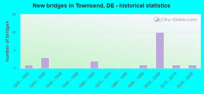
- New bridges - historical statistics
- 11920-1929
- 31930-1939
- 21960-1969
- 11990-1999
- 102000-2009
- 12010-2019
- 12020-2022
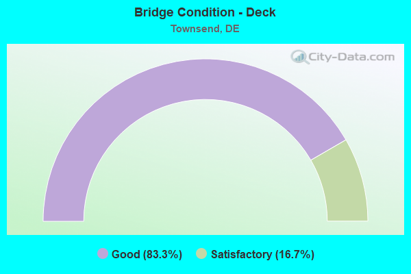
- Bridge Condition - Deck
- 83.3%Good
- 16.7%Satisfactory
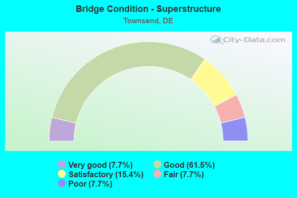
- Bridge Condition - Superstructure
- 7.7%Very good
- 61.5%Good
- 15.4%Satisfactory
- 7.7%Fair
- 7.7%Poor
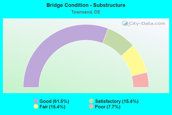
- Bridge Condition - Substructure
- 61.5%Good
- 15.4%Satisfactory
- 15.4%Fair
- 7.7%Poor
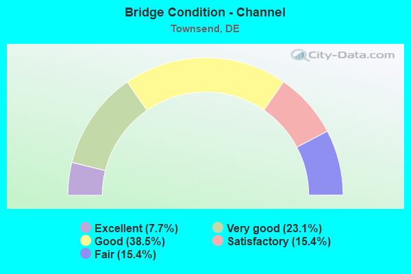
- Bridge Condition - Channel
- 7.7%Excellent
- 23.1%Very good
- 38.5%Good
- 15.4%Satisfactory
- 15.4%Fair
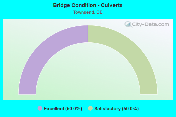
- Bridge Condition - Culverts
- 50.0%Excellent
- 50.0%Satisfactory
Find on map >> Show street view
Structure Number: 1420 461, Location: WEST OF TOWNSEND (Lat: 39.377547, Lng: -75.766550), Route carried "on" structure: County highway 461, Year Built: 2021, Status: Open, Structure Length: 0.87m (2.85ft), Average Daily Traffic: 223 (year 2020), Truck Traffic: 13%, Average Future Daily Traffic: 277 (year 2043), Design Load: HS 20, Features Intersected: TRIB OF SASSAFRAS RIVER, Facility Carried by Structure: MARYLAND LINE RD.
Minimum Vertical Clearance: 30.48m (100.00ft), Kilometerpoint: 1.931, Lanes on structure: 2, Owner: State Highway Agency, Approaching Roadway Width: 8.7m (28.5ft), Material/Design: Concrete, Design/Construction: Culvert, Number Of Spans In Main Unit: 3, Length of Maximum Span: 2.4m (7.9ft)
Condition: Channel: Excellent, Culverts: Excellent, Operating Rating: 54.4 metric tons, Method Used To Determine Operating Rating: Field evaluation and documented engineering judgment, Inventory Rating: 32.7 metric tons, Method Used To Determine Inventory Rating: Field evaluation and documented engineering judgment, Structural Evaluation: Superior to present desirable criteria, Waterway Adequacy: Better than present minimum criteria, Approach Roadway Alignment: Equal to present desirable criteria, Designated Inspection Frequency: Every 24 months, Inspection Date: May 2021
Find on map >> Show street view
Structure Number: 1424 446, Location: N. TOWNSEND LIMITS (Lat: 39.403439, Lng: -75.704228), Route carried "on" structure: County highway 446, Year Built: 1998, Status: Open, Structure Length: 1.50m (4.92ft), Average Daily Traffic: 1,151 (year 2019), Truck Traffic: 9%, Average Future Daily Traffic: 1,444 (year 2043), Design Load: HS 20, Features Intersected: CATTAIL BRANCH, Facility Carried by Structure: WIGGINS MILL RD.
Minimum Vertical Clearance: 30.48m (100.00ft), Kilometerpoint: 1.368, Lanes on structure: 2, Owner: State Highway Agency, Approaching Roadway Width: 6.2m (20.3ft), Skew: 1 degrees, Material/Design: Prestressed concrete, Design/Construction: Box Beam or Girders - Multiple, Number Of Spans In Main Unit: 1, Length of Maximum Span: 14.1m (46.3ft), Curb-To-Curb Width: 8.8m (28.9ft), Out-to-Out Width: 9.8m (32.2ft)
Condition: Deck: Good, Superstructure: Good, Substructure: Satisfactory, Channel: Very good, Operating Rating: 64.2 metric tons, Method Used To Determine Operating Rating: Load and Resistance Factor Rating (LRFR) rating reported by rating factor(RF) method using HL-93 loadings, Inventory Rating: 50.2 metric tons, Method Used To Determine Inventory Rating: Load and Resistance Factor Rating (LRFR) rating reported by rating factor(RF) method using HL-93 loadings, Structural Evaluation: Equal to present minimum criteria, Deck Geometry: Somewhat better than minimum adequacy, Waterway Adequacy: Better than present minimum criteria, Approach Roadway Alignment: Equal to present desirable criteria, Designated Inspection Frequency: Every 24 months, Inspection Date: April 2021, Deck Structure Type: Concrete Cast-file-Place, Wearing Surface/Protective System: Wearing Surface: Monolithic Concrete, Deck Protection: Epoxy Coated Reinforcing
Find on map >> Show street view
Structure Number: 1427 459, Location: WEST OF BLACKBIRD (Lat: 39.366133, Lng: -75.695061), Route carried "on" structure: County highway 459, Year Built: 1935, Status: Open, Structure Length: 0.61m (2.00ft), Average Daily Traffic: 1,312 (year 2020), Truck Traffic: 13%, Average Future Daily Traffic: 1,630 (year 2043), Features Intersected: BARLOW BRANCH, Facility Carried by Structure: GREARS CORNER RD.
Minimum Vertical Clearance: 30.48m (100.00ft), Kilometerpoint: 0.451, Lanes on structure: 2, Owner: State Highway Agency, Approaching Roadway Width: 5.5m (18.0ft), Material/Design: Concrete, Design/Construction: Culvert, Number Of Spans In Main Unit: 1, Length of Maximum Span: 6.1m (20.0ft), Curb-To-Curb Width: 7.4m (24.3ft), Out-to-Out Width: 8.1m (26.6ft)
Condition: Channel: Satisfactory, Culverts: Satisfactory, Operating Rating: 54.4 metric tons, Method Used To Determine Operating Rating: Field evaluation and documented engineering judgment, Inventory Rating: 32.7 metric tons, Method Used To Determine Inventory Rating: Field evaluation and documented engineering judgment, Structural Evaluation: Equal to present minimum criteria, Deck Geometry: Meets minimum limits, Waterway Adequacy: Better than present minimum criteria, Approach Roadway Alignment: Equal to present desirable criteria, Designated Inspection Frequency: Every 24 months, Inspection Date: May 2021, Deck Structure Type: Concrete Cast-file-Place, Wearing Surface/Protective System: Wearing Surface: Bituminous
Find on map >> Show street view
Structure Number: 1438 463, Location: S.W. OF BLACKBIRD (Lat: 39.366164, Lng: -75.669406), Route carried "on" structure: County highway 463, Year Built: 2017, Status: Open, Structure Length: 1.62m (5.31ft), Average Daily Traffic: 843 (year 2020), Truck Traffic: 13%, Average Future Daily Traffic: 1,047 (year 2043), Design Load: HL 93, Features Intersected: BLACKBIRD CREEK, Facility Carried by Structure: BLACKBIRD STA RD
Minimum Vertical Clearance: 30.48m (100.00ft), Kilometerpoint: 0.338, Lanes on structure: 2, Owner: State Highway Agency, Approaching Roadway Width: 6.7m (22.0ft), Skew: 1 degrees, Material/Design: Prestressed concrete, Design/Construction: Box Beam or Girders - Multiple, Number Of Spans In Main Unit: 1, Length of Maximum Span: 15.2m (49.9ft), Curb-To-Curb Width: 11.0m (36.1ft), Out-to-Out Width: 12.5m (41.0ft)
Condition: Deck: Good, Superstructure: Very good, Substructure: Good, Channel: Satisfactory, Operating Rating: 45.0 metric tons, Method Used To Determine Operating Rating: Load and Resistance Factor Rating (LRFR) rating reported by rating factor(RF) method using HL-93 loadings, Inventory Rating: 36.0 metric tons, Method Used To Determine Inventory Rating: Load and Resistance Factor Rating (LRFR) rating reported by rating factor(RF) method using HL-93 loadings, Structural Evaluation: Better than present minimum criteria, Deck Geometry: Better than present minimum criteria, Waterway Adequacy: Better than present minimum criteria, Approach Roadway Alignment: Better than present minimum criteria, Length Of Structure Improvement: 0.73m (2.40ft), Designated Inspection Frequency: Every 24 months, Inspection Date: October 2021, Total Project Cost: $250,000, Deck Structure Type: Concrete Precast Panels, Wearing Surface/Protective System: Wearing Surface: Other
Find on map >> Show street view
Structure Number: 1440 014, Location: N. TOWNSEND LIMITS (Lat: 39.408375, Lng: -75.699053), Route carried "on" structure: County highway 14, Year Built: 1936, Year Reconstructed: 1948, Status: Open, Structure Length: 1.16m (3.81ft), Average Daily Traffic: 8,058 (year 2019), Truck Traffic: 9%, Average Future Daily Traffic: 10,110 (year 2043), Features Intersected: CATTAIL BRANCH, Facility Carried by Structure: SUMMIT BRIDGE RD
Minimum Vertical Clearance: 30.48m (100.00ft), Kilometerpoint: 4.290, Lanes on structure: 2, Base Highway Network: Yes, Owner: State Highway Agency, Approaching Roadway Width: 13.9m (45.6ft), Material/Design: Steel, Design/Construction: Stringer/Multi-beam, Number Of Spans In Main Unit: 1, Length of Maximum Span: 11.0m (36.1ft), Curb-To-Curb Width: 13.2m (43.3ft), Out-to-Out Width: 18.1m (59.4ft)
Condition: Deck: Good, Superstructure: Satisfactory, Substructure: Good, Channel: Good, Operating Rating: 49.6 metric tons, Method Used To Determine Operating Rating: Load and Resistance Factor Rating (LRFR) rating reported by rating factor(RF) method using HL-93 loadings, Inventory Rating: 38.2 metric tons, Method Used To Determine Inventory Rating: Load and Resistance Factor Rating (LRFR) rating reported by rating factor(RF) method using HL-93 loadings, Structural Evaluation: Equal to present minimum criteria, Deck Geometry: Somewhat better than minimum adequacy, Waterway Adequacy: Equal to present minimum criteria, Approach Roadway Alignment: Equal to present desirable criteria, Designated Inspection Frequency: Every 24 months, Inspection Date: April 2021, Deck Structure Type: Concrete Cast-file-Place, Wearing Surface/Protective System: Wearing Surface: Bituminous
Find on map >> Show street view
Structure Number: 1448 456, Location: E. OF TOWNSEND (Lat: 39.402464, Lng: -75.628042), Route carried "on" structure: County highway 456, Year Built: 1968, Status: Open, Structure Length: 0.97m (3.18ft), Average Daily Traffic: 219 (year 2020), Truck Traffic: 13%, Average Future Daily Traffic: 272 (year 2043), Design Load: H 20, Features Intersected: BEAVER BRANCH, Facility Carried by Structure: UNION CHURCH RD.
Minimum Vertical Clearance: 30.48m (100.00ft), Kilometerpoint: 3.895, Lanes on structure: 2, Owner: State Highway Agency, Approaching Roadway Width: 5.2m (17.1ft), Material/Design: Wood or Timber, Design/Construction: Stringer/Multi-beam, Number Of Spans In Main Unit: 2, Length of Maximum Span: 4.6m (15.1ft), Curb-To-Curb Width: 8.5m (27.9ft), Out-to-Out Width: 9.5m (31.2ft)
Condition: Deck: Satisfactory, Superstructure: Good, Substructure: Fair, Channel: Very good, Operating Rating: 55.1 metric tons, Method Used To Determine Operating Rating: Load Factor (LF), Inventory Rating: 40.4 metric tons, Method Used To Determine Inventory Rating: Load Factor (LF), Structural Evaluation: Somewhat better than minimum adequacy, Deck Geometry: Equal to present minimum criteria, Waterway Adequacy: Better than present minimum criteria, Approach Roadway Alignment: Equal to present desirable criteria, Designated Inspection Frequency: Every 24 months, Underwater Inspection Frequency: Every 24 months, Inspection Date: June 2021, Underwater Inspection Date: April 2021, Deck Structure Type: Wood or Timber, Wearing Surface/Protective System: Wearing Surface: Wood or Timber
Find on map >> Show street view
Structure Number: 1451 455, Location: E. OF TOWNSEND (Lat: 39.388719, Lng: -75.635944), Route carried "on" structure: County highway 455, Year Built: 1969, Status: Open, Structure Length: 2.64m (8.66ft), Average Daily Traffic: 1,382 (year 2020), Truck Traffic: 13%, Average Future Daily Traffic: 1,717 (year 2043), Design Load: HS 20, Features Intersected: BLACKBIRD CREEK, Facility Carried by Structure: BLACKBIRD LANDING
Minimum Vertical Clearance: 30.48m (100.00ft), Kilometerpoint: 2.044, Lanes on structure: 2, Owner: State Highway Agency, Approaching Roadway Width: 5.5m (18.0ft), Material/Design: Prestressed concrete, Design/Construction: Box Beam or Girders - Multiple, Number Of Spans In Main Unit: 2, Length of Maximum Span: 12.7m (41.7ft), Curb or Sidewalk Widths: Left: 0.6m (2.0ft), Right: 0.6m (2.0ft), Curb-To-Curb Width: 8.5m (27.9ft), Out-to-Out Width: 10.4m (34.1ft)
Condition: Deck: Satisfactory, Superstructure: Fair, Substructure: Fair, Channel: Very good, Operating Rating: 97.2 metric tons, Method Used To Determine Operating Rating: Load and Resistance Factor Rating (LRFR) rating reported by rating factor(RF) method using HL-93 loadings, Inventory Rating: 97.2 metric tons, Method Used To Determine Inventory Rating: Load and Resistance Factor Rating (LRFR) rating reported by rating factor(RF) method using HL-93 loadings, Structural Evaluation: Somewhat better than minimum adequacy, Deck Geometry: Somewhat better than minimum adequacy, Waterway Adequacy: Better than present minimum criteria, Approach Roadway Alignment: Equal to present desirable criteria, Designated Inspection Frequency: Every 24 months, Underwater Inspection Frequency: Every 24 months, Inspection Date: May 2021, Underwater Inspection Date: March 2021, Deck Structure Type: Concrete Precast Panels, Wearing Surface/Protective System: Wearing Surface: Bituminous
Find on map >> Show street view
Structure Number: 1488N001, Location: NORTH OF BLACKBIRD (Lat: 39.372775, Lng: -75.661475), Route carried "on" structure: US 13, Year Built: 1933, Status: Open, Structure Length: 1.46m (4.79ft), Average Daily Traffic: 9,465 (year 2019), Truck Traffic: 10%, Average Future Daily Traffic: 11,764 (year 2042), Design Load: H 20, Features Intersected: BLACKBIRD CREEK
Minimum Vertical Clearance: 30.48m (100.00ft), Kilometerpoint: 8.513, Lanes on structure: 2, Base Highway Network: Yes, Owner: State Highway Agency, Approaching Roadway Width: 11.0m (36.1ft), Material/Design: Concrete, Design/Construction: Slab, Number Of Spans In Main Unit: 2, Length of Maximum Span: 6.1m (20.0ft), Curb-To-Curb Width: 11.3m (37.1ft), Out-to-Out Width: 12.5m (41.0ft)
Condition: Deck: Good, Superstructure: Good, Substructure: Satisfactory, Channel: Fair, Operating Rating: 34.7 metric tons, Method Used To Determine Operating Rating: Load and Resistance Factor Rating (LRFR) rating reported by rating factor(RF) method using HL-93 loadings, Inventory Rating: 26.6 metric tons, Method Used To Determine Inventory Rating: Load and Resistance Factor Rating (LRFR) rating reported by rating factor(RF) method using HL-93 loadings, Structural Evaluation: Equal to present minimum criteria, Deck Geometry: Equal to present minimum criteria, Waterway Adequacy: Equal to present minimum criteria, Approach Roadway Alignment: Equal to present desirable criteria, Designated Inspection Frequency: Every 24 months, Underwater Inspection Frequency: Every 48 months, Inspection Date: July 2020, Underwater Inspection Date: June 2018, Deck Structure Type: Concrete Cast-file-Place, Wearing Surface/Protective System: Wearing Surface: Bituminous
Find on map >> Show street view
Structure Number: 1488S001, Location: NORTH OF BLACKBIRD (Lat: 39.372669, Lng: -75.661661), Route carried "on" structure: US 13, Year Built: 1920, Status: Open, Structure Length: 1.28m (4.20ft), Average Daily Traffic: 7,525 (year 2020), Truck Traffic: 9%, Average Future Daily Traffic: 11,764 (year 2042), Design Load: H 20, Features Intersected: BLACKBIRD CREEK
Minimum Vertical Clearance: 30.48m (100.00ft), Kilometerpoint: 27.439, Lanes on structure: 2, Base Highway Network: Yes, Owner: State Highway Agency, Approaching Roadway Width: 10.1m (33.1ft), Material/Design: Concrete, Design/Construction: Arch - Deck, Number Of Spans In Main Unit: 1, Length of Maximum Span: 12.8m (42.0ft), Curb-To-Curb Width: 9.8m (32.2ft), Out-to-Out Width: 12.4m (40.7ft)
Condition: Superstructure: Poor, Substructure: Poor, Channel: Fair, Operating Rating: 55.7 metric tons, Method Used To Determine Operating Rating: Load and Resistance Factor Rating (LRFR) rating reported by rating factor(RF) method using HL-93 loadings, Inventory Rating: 42.8 metric tons, Method Used To Determine Inventory Rating: Load and Resistance Factor Rating (LRFR) rating reported by rating factor(RF) method using HL-93 loadings, Structural Evaluation: Meets minimum limits, Deck Geometry: Meets minimum limits, Waterway Adequacy: Equal to present minimum criteria, Approach Roadway Alignment: Equal to present desirable criteria, Length Of Structure Improvement: 3.05m (10.01ft), Designated Inspection Frequency: Every 12 months, Inspection Date: July 2021, Bridge Improvement Cost: $1,000, Roadway Improvement Cost: $1,000, Total Project Cost: $2,000
Find on map >> Show street view
Structure Number: 1908N08, Location: S. OF TOWNSEND (Lat: 39.386036, Lng: -75.664236), Route carried "on" structure: State highway 1, Year Built: 2003, Status: Open, Structure Length: 9.34m (30.64ft), Average Daily Traffic: 26,437 (year 2019), Truck Traffic: 9%, Average Future Daily Traffic: 33,171 (year 2043), Design Load: HS 20+Mod, Features Intersected: DUPONT HGWY/ US13, Facility Carried by Structure: KOREAN VET MEM HWY
Minimum Vertical Clearance: 30.48m (100.00ft), Kilometerpoint: 10.509, Lanes on structure: 2, Lanes under structure: 4, Base Highway Network: Yes, Toll: On toll road, Owner: State Highway Agency, Approaching Roadway Width: 11.6m (38.1ft), Skew: 6 degrees, Material/Design: Steel continuous, Design/Construction: Stringer/Multi-beam, Number Of Spans In Main Unit: 2, Length of Maximum Span: 43.7m (143.4ft), Curb-To-Curb Width: 12.8m (42.0ft), Out-to-Out Width: 13.6m (44.6ft)
Condition: Deck: Good, Superstructure: Satisfactory, Substructure: Good, Operating Rating: 85.5 metric tons, Method Used To Determine Operating Rating: Load and Resistance Factor Rating (LRFR) rating reported by rating factor(RF) method using HL-93 loadings, Inventory Rating: 66.1 metric tons, Method Used To Determine Inventory Rating: Load and Resistance Factor Rating (LRFR) rating reported by rating factor(RF) method using HL-93 loadings, Structural Evaluation: Equal to present minimum criteria, Deck Geometry: Equal to present desirable criteria, Underclear: Equal to present minimum criteria, Approach Roadway Alignment: Equal to present desirable criteria, Designated Inspection Frequency: Every 24 months, Inspection Date: April 2021, Deck Structure Type: Concrete Cast-file-Place, Wearing Surface/Protective System: Wearing Surface: Monolithic Concrete, Deck Protection: Epoxy Coated Reinforcing
Find on map >> Show street view
Structure Number: 1908S08, Location: S. OF TOWNSEND (Lat: 39.385514, Lng: -75.664333), Route carried "on" structure: State highway 1, Year Built: 2002, Status: Open, Structure Length: 9.24m (30.31ft), Average Daily Traffic: 26,437 (year 2019), Truck Traffic: 9%, Average Future Daily Traffic: 33,171 (year 2043), Design Load: HS 20+Mod, Features Intersected: DUPONT HGWY/US13, Facility Carried by Structure: KOREAN VET MEM HWY
Minimum Vertical Clearance: 30.48m (100.00ft), Kilometerpoint: 10.557, Lanes on structure: 2, Lanes under structure: 4, Base Highway Network: Yes, Toll: On toll road, Owner: State Highway Agency, Approaching Roadway Width: 12.8m (42.0ft), Skew: 6 degrees, Material/Design: Steel continuous, Design/Construction: Stringer/Multi-beam, Number Of Spans In Main Unit: 2, Length of Maximum Span: 43.7m (143.4ft), Curb-To-Curb Width: 12.8m (42.0ft), Out-to-Out Width: 13.6m (44.6ft)
Condition: Deck: Good, Superstructure: Good, Substructure: Good, Operating Rating: 85.5 metric tons, Method Used To Determine Operating Rating: Load and Resistance Factor Rating (LRFR) rating reported by rating factor(RF) method using HL-93 loadings, Inventory Rating: 66.1 metric tons, Method Used To Determine Inventory Rating: Load and Resistance Factor Rating (LRFR) rating reported by rating factor(RF) method using HL-93 loadings, Structural Evaluation: Better than present minimum criteria, Deck Geometry: Equal to present desirable criteria, Underclear: Equal to present minimum criteria, Approach Roadway Alignment: Equal to present desirable criteria, Designated Inspection Frequency: Every 24 months, Inspection Date: April 2021, Deck Structure Type: Concrete Cast-file-Place, Wearing Surface/Protective System: Wearing Surface: Monolithic Concrete, Deck Protection: Epoxy Coated Reinforcing
Find on map >> Show street view
Structure Number: 1909N08, Location: S.E. OF TOWNSEND (Lat: 39.374631, Lng: -75.658428), Route carried "on" structure: State highway 1, Year Built: 2003, Status: Open, Structure Length: 16.06m (52.69ft), Average Daily Traffic: 21,017 (year 2020), Truck Traffic: 1%, Average Future Daily Traffic: 26,122 (year 2043), Design Load: HS 25 or greater, Features Intersected: BLACKBIRD CREEK, Facility Carried by Structure: KOREAN VET MEM HWY
Minimum Vertical Clearance: 30.48m (100.00ft), Kilometerpoint: 9.125, Lanes on structure: 2, Base Highway Network: Yes, Toll: On toll road, Owner: State Highway Agency, Approaching Roadway Width: 12.2m (40.0ft), Material/Design: Prestressed concrete continuous, Design/Construction: Stringer/Multi-beam, Number Of Spans In Main Unit: 8, Length of Maximum Span: 19.8m (65.0ft), Curb-To-Curb Width: 12.8m (42.0ft), Out-to-Out Width: 13.6m (44.6ft)
Condition: Deck: Good, Superstructure: Good, Substructure: Good, Channel: Good, Operating Rating: 70.3 metric tons, Method Used To Determine Operating Rating: Load and Resistance Factor Rating (LRFR) rating reported by rating factor(RF) method using HL-93 loadings, Inventory Rating: 41.8 metric tons, Method Used To Determine Inventory Rating: Load and Resistance Factor Rating (LRFR) rating reported by rating factor(RF) method using HL-93 loadings, Structural Evaluation: Better than present minimum criteria, Deck Geometry: Equal to present desirable criteria, Waterway Adequacy: Superior to present desirable criteria, Approach Roadway Alignment: Equal to present desirable criteria, Designated Inspection Frequency: Every 24 months, Inspection Date: May 2021, Deck Structure Type: Concrete Cast-file-Place, Wearing Surface/Protective System: Wearing Surface: Monolithic Concrete, Deck Protection: Epoxy Coated Reinforcing
Find on map >> Show street view
Structure Number: 1909S08, Location: S/E OF TOWNSEND (Lat: 39.374544, Lng: -75.658747), Route carried "on" structure: State highway 1, Year Built: 2003, Status: Open, Structure Length: 16.06m (52.69ft), Average Daily Traffic: 21,017 (year 2020), Truck Traffic: 9%, Average Future Daily Traffic: 26,122 (year 2043), Design Load: HS 25 or greater, Features Intersected: BLACKBIRD CREEK, Facility Carried by Structure: KOREAN VET MEM HWY
Minimum Vertical Clearance: 30.48m (100.00ft), Kilometerpoint: 9.125, Lanes on structure: 2, Base Highway Network: Yes, Toll: On toll road, Owner: State Highway Agency, Approaching Roadway Width: 12.2m (40.0ft), Material/Design: Prestressed concrete continuous, Design/Construction: Stringer/Multi-beam, Number Of Spans In Main Unit: 8, Length of Maximum Span: 19.8m (65.0ft), Curb-To-Curb Width: 12.8m (42.0ft), Out-to-Out Width: 13.6m (44.6ft)
Condition: Deck: Good, Superstructure: Good, Substructure: Good, Channel: Good, Operating Rating: 70.3 metric tons, Method Used To Determine Operating Rating: Load and Resistance Factor Rating (LRFR) rating reported by rating factor(RF) method using HL-93 loadings, Inventory Rating: 41.8 metric tons, Method Used To Determine Inventory Rating: Load and Resistance Factor Rating (LRFR) rating reported by rating factor(RF) method using HL-93 loadings, Structural Evaluation: Better than present minimum criteria, Deck Geometry: Equal to present desirable criteria, Waterway Adequacy: Equal to present desirable criteria, Approach Roadway Alignment: Equal to present desirable criteria, Designated Inspection Frequency: Every 24 months, Inspection Date: May 2021, Deck Structure Type: Concrete Cast-file-Place, Wearing Surface/Protective System: Wearing Surface: Monolithic Concrete, Deck Protection: Epoxy Coated Reinforcing
Find on map >> Show street view
Structure Number: 1910N08, Location: BLACKBIRD AREA (Lat: 39.367814, Lng: -75.655469), Route carried "on" structure: State highway 80, Year Built: 2003, Status: Open, Structure Length: 13.57m (44.52ft), Average Daily Traffic: 21,017 (year 2020), Truck Traffic: 9%, Average Future Daily Traffic: 26,122 (year 2043), Design Load: HS 20+Mod, Features Intersected: DUPONT PKY&SANDOM BRNCH, Facility Carried by Structure: KOREAN VET MEM HWY
Minimum Vertical Clearance: 30.48m (100.00ft), Kilometerpoint: 8.369, Lanes on structure: 2, Lanes under structure: 5, Base Highway Network: Yes, Toll: On toll road, Owner: State Highway Agency, Approaching Roadway Width: 12.2m (40.0ft), Skew: 9 degrees, Material/Design: Steel continuous, Design/Construction: Stringer/Multi-beam, Number Of Spans In Main Unit: 3, Length of Maximum Span: 55.2m (181.1ft), Curb-To-Curb Width: 12.8m (42.0ft), Out-to-Out Width: 13.6m (44.6ft)
Condition: Deck: Good, Superstructure: Good, Substructure: Good, Channel: Good, Operating Rating: 60.6 metric tons, Method Used To Determine Operating Rating: Load and Resistance Factor Rating (LRFR) rating reported by rating factor(RF) method using HL-93 loadings, Inventory Rating: 46.7 metric tons, Method Used To Determine Inventory Rating: Load and Resistance Factor Rating (LRFR) rating reported by rating factor(RF) method using HL-93 loadings, Structural Evaluation: Better than present minimum criteria, Deck Geometry: Equal to present desirable criteria, Underclear: Better than present minimum criteria, Waterway Adequacy: Superior to present desirable criteria, Approach Roadway Alignment: Equal to present desirable criteria, Designated Inspection Frequency: Every 24 months, Inspection Date: April 2021, Deck Structure Type: Concrete Cast-file-Place, Wearing Surface/Protective System: Wearing Surface: Monolithic Concrete, Deck Protection: Epoxy Coated Reinforcing
Find on map >> Show street view
Structure Number: 1910S08, Location: BLACKBIRD AREA (Lat: 39.368114, Lng: -75.655906), Route carried "on" structure: State highway 1, Year Built: 2003, Status: Open, Structure Length: 20.14m (66.08ft), Average Daily Traffic: 21,017 (year 2020), Truck Traffic: 9%, Average Future Daily Traffic: 26,122 (year 2043), Design Load: HS 20+Mod, Features Intersected: DUPONT PKY&SANDOM BRNCH, Facility Carried by Structure: KOREAN VET MEM HWY
Minimum Vertical Clearance: 30.48m (100.00ft), Kilometerpoint: 24.720, Lanes on structure: 2, Lanes under structure: 5, Base Highway Network: Yes, Toll: On toll road, Owner: State Highway Agency, Approaching Roadway Width: 12.2m (40.0ft), Skew: 5 degrees, Material/Design: Steel continuous, Design/Construction: Stringer/Multi-beam, Number Of Spans In Main Unit: 4, Length of Maximum Span: 62.6m (205.4ft), Curb-To-Curb Width: 12.8m (42.0ft), Out-to-Out Width: 13.6m (44.6ft)
Condition: Deck: Good, Superstructure: Good, Substructure: Good, Channel: Good, Operating Rating: 55.1 metric tons, Method Used To Determine Operating Rating: Load and Resistance Factor Rating (LRFR) rating reported by rating factor(RF) method using HL-93 loadings, Inventory Rating: 42.4 metric tons, Method Used To Determine Inventory Rating: Load and Resistance Factor Rating (LRFR) rating reported by rating factor(RF) method using HL-93 loadings, Structural Evaluation: Better than present minimum criteria, Deck Geometry: Equal to present desirable criteria, Underclear: Equal to present minimum criteria, Waterway Adequacy: Superior to present desirable criteria, Approach Roadway Alignment: Equal to present desirable criteria, Designated Inspection Frequency: Every 24 months, Inspection Date: April 2021, Deck Structure Type: Concrete Cast-file-Place, Wearing Surface/Protective System: Wearing Surface: Monolithic Concrete, Deck Protection: Epoxy Coated Reinforcing
Find on map >> Show street view
Structure Number: 1908N08, Location: S. OF TOWNSEND (Lat: 39.386036, Lng: -75.664236), Route carried "under" structure: US 13, Year Built: 2003, Structure Length: 0. m, Average Daily Traffic: 13,811 (year 2019), Truck Traffic: 10%, Features Intersected: DUPONT HGWY/ US13, Facility Carried by Structure: KOREAN VET MEM HWY
Minimum Vertical Clearance: 5.89m (19.32ft), Kilometerpoint: 9.801, Lanes on structure: 2, Lanes under structure: 4, Material/Design: Steel continuous, Design/Construction: Stringer/Multi-beam, Length of Maximum Span: 43.7m (143.4ft)
Find on map >> Show street view
Structure Number: 1908S08, Location: S. OF TOWNSEND (Lat: 39.385514, Lng: -75.664333), Route carried "under" structure: US 13, Year Built: 2002, Structure Length: 0. m, Average Daily Traffic: 13,811 (year 2019), Truck Traffic: 10%, Features Intersected: DUPONT HGWY/US13, Facility Carried by Structure: KOREAN VET MEM HWY
Minimum Vertical Clearance: 5.39m (17.68ft), Kilometerpoint: 9.801, Lanes on structure: 2, Lanes under structure: 4, Material/Design: Steel continuous, Design/Construction: Stringer/Multi-beam, Length of Maximum Span: 43.7m (143.4ft)
Find on map >> Show street view
Structure Number: 1910N08, Location: BLACKBIRD AREA (Lat: 39.367814, Lng: -75.655469), Route carried "under" structure: US 13, Year Built: 2003, Structure Length: 0. m, Average Daily Traffic: 7,525 (year 2020), Truck Traffic: 9%, Features Intersected: DUPONT PKY&SANDOM BRNCH, Facility Carried by Structure: KOREAN VET MEM HWY
Minimum Vertical Clearance: 8.11m (26.61ft), Kilometerpoint: 6.130, Lanes on structure: 2, Lanes under structure: 5, Material/Design: Steel continuous, Design/Construction: Stringer/Multi-beam, Length of Maximum Span: 55.2m (181.1ft)
Find on map >> Show street view
Structure Number: 1910S08, Location: BLACKBIRD AREA (Lat: 39.368114, Lng: -75.655906), Route carried "under" structure: US 13, Year Built: 2003, Structure Length: 0. m, Average Daily Traffic: 7,525 (year 2020), Truck Traffic: 9%, Features Intersected: DUPONT PKY&SANDOM BRNCH, Facility Carried by Structure: KOREAN VET MEM HWY
Minimum Vertical Clearance: 6.02m (19.75ft), Kilometerpoint: 7.644, Lanes on structure: 2, Lanes under structure: 5, Material/Design: Steel continuous, Design/Construction: Stringer/Multi-beam, Length of Maximum Span: 62.6m (205.4ft)