Bridge Statistics for Town Line, New York (NY)
Condition, Traffic, Stress, Structural Evaluation, Project Costs
- National Bridge Inventory (NBI) Statistics
- 13Number of bridges
- 108ft / 32.9mTotal length
- $23,963,000Total costs
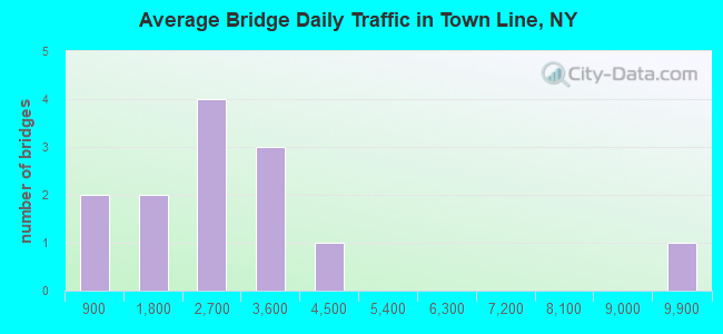
- 33,974Total average daily traffic
- 1,880Total average daily truck traffic
- 41,420Total future (year 2036) average daily traffic
- National Bridge Inventory (NBI) Registered Bridges for Town Line
- No street view available for this location
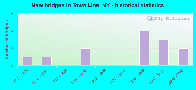
- New bridges - historical statistics
- 11920-1929
- 11930-1939
- 21950-1959
- 41980-1989
- 31990-1999
- 22000-2009
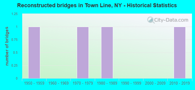
- Reconstructed bridges - Historical Statistics
- 11950-1959
- 01960-1969
- 11970-1979
- 11980-1989
- 01990-1999
- 02000-2009
- 12010-2019
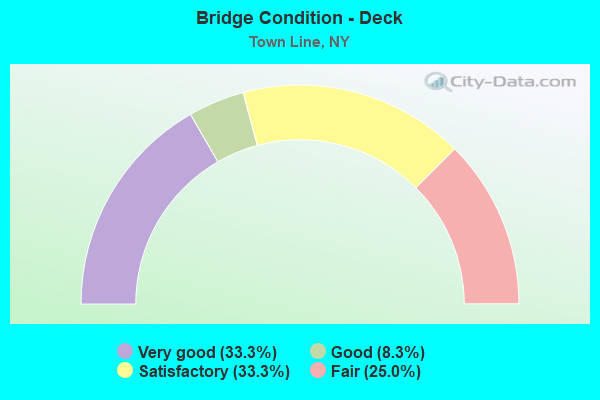
- Bridge Condition - Deck
- 33.3%Very good
- 8.3%Good
- 33.3%Satisfactory
- 25.0%Fair
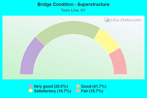
- Bridge Condition - Superstructure
- 25.0%Very good
- 41.7%Good
- 16.7%Satisfactory
- 16.7%Fair
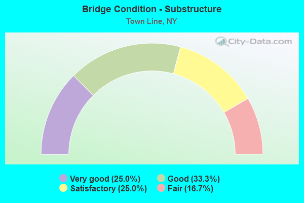
- Bridge Condition - Substructure
- 25.0%Very good
- 33.3%Good
- 25.0%Satisfactory
- 16.7%Fair
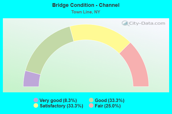
- Bridge Condition - Channel
- 8.3%Very good
- 33.3%Good
- 33.3%Satisfactory
- 25.0%Fair
Find on map >> Show street view
Structure Number: 101559, Location: 2.7 MI W JCT RTS 20 + 358 (Lat: 42.891617, Lng: -78.604197), Route carried "on" structure: US 20, Year Built: 1931, Year Reconstructed: 1956, Status: Open, Structure Length: 1.04m (3.41ft), Average Daily Traffic: 9,761 (year 2018), Truck Traffic: 6%, Average Future Daily Traffic: 9,806 (year 2040), Design Load: HS 20+Mod, Features Intersected: BR CAYUGA CREEK
Minimum Vertical Clearance: 30+ m (98+ ft), Kilometerpoint: 61.898, Lanes on structure: 4, Base Highway Network: Yes, Owner: State Highway Agency, Approaching Roadway Width: 20.4m (66.9ft), Skew: 24 degrees, Material/Design: Concrete, Design/Construction: Slab, Number Of Spans In Main Unit: 1, Length of Maximum Span: 9.1m (29.9ft), Curb-To-Curb Width: 20.4m (66.9ft), Out-to-Out Width: 21.6m (70.9ft)
Condition: Deck: Satisfactory, Superstructure: Fair, Substructure: Fair, Channel: Very good, Operating Rating: 47.0 metric tons, Method Used To Determine Operating Rating: Load and Resistance Factor Rating (LRFR) rating reported by rating factor(RF) method using HL-93 loadings, Inventory Rating: 36.3 metric tons, Method Used To Determine Inventory Rating: Load and Resistance Factor Rating (LRFR) rating reported by rating factor(RF) method using HL-93 loadings, Structural Evaluation: Somewhat better than minimum adequacy, Deck Geometry: Superior to present desirable criteria, Waterway Adequacy: Somewhat better than minimum adequacy, Approach Roadway Alignment: Equal to present desirable criteria, Length Of Structure Improvement: 1.03m (3.38ft), Designated Inspection Frequency: Every 24 months, Inspection Date: July 2020, Bridge Improvement Cost: $1,566,000, Roadway Improvement Cost: $917,000, Total Project Cost: $2,483,000 ( Estimate for 2021), Wearing Surface/Protective System: Wearing Surface: Bituminous
Find on map >> Show street view
Structure Number: 104659, Location: IN ALDEN (Lat: 42.883447, Lng: -78.552364), Route carried "on" structure: County highway , Year Built: 1998, Status: Open, Structure Length: 3.38m (11.09ft), Average Daily Traffic: 2,386 (year 2017), Truck Traffic: 7%, Average Future Daily Traffic: 2,952 (year 2040), Design Load: HS 25 or greater, Features Intersected: CAYUGA CREEK, Facility Carried by Structure: TWO ROD ROAD
Minimum Vertical Clearance: 30+ m (98+ ft), Kilometerpoint: 3.073, Lanes on structure: 2, Owner: County Highway Agency, Approaching Roadway Width: 8.5m (27.9ft), Material/Design: Prestressed concrete, Design/Construction: Box Beam or Girders - Multiple, Number Of Spans In Main Unit: 1, Length of Maximum Span: 32.9m (107.9ft), Curb-To-Curb Width: 8.4m (27.6ft), Out-to-Out Width: 9.0m (29.5ft)
Condition: Deck: Very good, Superstructure: Very good, Substructure: Good, Channel: Satisfactory, Operating Rating: 89.8 metric tons, Method Used To Determine Operating Rating: Load Factor (LF), Inventory Rating: 40.8 metric tons, Method Used To Determine Inventory Rating: Load Factor (LF), Structural Evaluation: Better than present minimum criteria, Deck Geometry: High priority of corrective action, Waterway Adequacy: Equal to present desirable criteria, Approach Roadway Alignment: Equal to present desirable criteria, Length Of Structure Improvement: 3.38m (11.09ft), Designated Inspection Frequency: Every 24 months, Inspection Date: September 2020, Bridge Improvement Cost: $1,084,000, Roadway Improvement Cost: $635,000, Total Project Cost: $1,718,000 ( Estimate for 2021), Deck Structure Type: Concrete Cast-file-Place, Wearing Surface/Protective System: Wearing Surface: Integral Concrete, Deck Protection: Epoxy Coated Reinforcing
Find on map >> Show street view
Structure Number: 332689, Location: .9 MILE NORTH OF TWN LINE (Lat: 42.902783, Lng: -78.578217), Route carried "on" structure: County highway , Year Built: 1987, Status: Open, Structure Length: 0.70m (2.30ft), Average Daily Traffic: 2,171 (year 2016), Truck Traffic: 5%, Average Future Daily Traffic: 3,039 (year 2036), Design Load: HS 20+Mod, Features Intersected: BRANCH CAYUGA CRK, Facility Carried by Structure: TOWN LINE ROAD
Minimum Vertical Clearance: 30+ m (98+ ft), Kilometerpoint: 7.031, Lanes on structure: 2, Owner: County Highway Agency, Approaching Roadway Width: 10.4m (34.1ft), Material/Design: Prestressed concrete, Design/Construction: Box Beam or Girders - Multiple, Number Of Spans In Main Unit: 1, Length of Maximum Span: 6.7m (22.0ft), Curb-To-Curb Width: 10.3m (33.8ft), Out-to-Out Width: 11.0m (36.1ft)
Condition: Deck: Fair, Superstructure: Satisfactory, Substructure: Good, Channel: Satisfactory, Inventory Rating: 68.0 metric tons, Method Used To Determine Inventory Rating: Load Factor (LF), Structural Evaluation: Equal to present minimum criteria, Deck Geometry: Meets minimum limits, Waterway Adequacy: Better than present minimum criteria, Approach Roadway Alignment: Equal to present desirable criteria, Length Of Structure Improvement: 0.70m (2.30ft), Designated Inspection Frequency: Every 24 months, Inspection Date: April 2020, Bridge Improvement Cost: $381,000, Roadway Improvement Cost: $223,000, Total Project Cost: $604,000 ( Estimate for 2021), Deck Structure Type: Concrete Cast-file-Place, Wearing Surface/Protective System: Wearing Surface: Integral Concrete, Deck Protection: Epoxy Coated Reinforcing
Find on map >> Show street view
Structure Number: 332698, Location: .7 MILE SOUTH OF TOWNLINE (Lat: 42.880003, Lng: -78.577803), Route carried "on" structure: County highway , Year Built: 1959, Year Reconstructed: 2019, Status: Open, Structure Length: 3.51m (11.52ft), Average Daily Traffic: 2,710 (year 2018), Truck Traffic: 6%, Average Future Daily Traffic: 3,794 (year 2038), Features Intersected: CAYUGA CREEK, Facility Carried by Structure: TOWN LINE ROAD
Minimum Vertical Clearance: 30+ m (98+ ft), Kilometerpoint: 4.505, Lanes on structure: 2, Owner: County Highway Agency, Approaching Roadway Width: 6.7m (22.0ft), Material/Design: Steel, Design/Construction: Stringer/Multi-beam, Number Of Spans In Main Unit: 2, Length of Maximum Span: 16.7m (54.8ft), Curb or Sidewalk Widths: Left: 0.9m (3.0ft), Right: 0.9m (3.0ft), Curb-To-Curb Width: 9.1m (29.9ft), Out-to-Out Width: 10.9m (35.8ft)
Condition: Deck: Fair, Superstructure: Fair, Substructure: Satisfactory, Channel: Fair, Operating Rating: 61.2 metric tons, Method Used To Determine Operating Rating: Load and Resistance Factor Rating (LRFR) rating reported by rating factor(RF) method using HL-93 loadings, Inventory Rating: 47.3 metric tons, Method Used To Determine Inventory Rating: Load and Resistance Factor Rating (LRFR) rating reported by rating factor(RF) method using HL-93 loadings, Structural Evaluation: Somewhat better than minimum adequacy, Deck Geometry: Meets minimum limits, Waterway Adequacy: Superior to present desirable criteria, Approach Roadway Alignment: Equal to present desirable criteria, Length Of Structure Improvement: 3.50m (11.48ft), Designated Inspection Frequency: Every 24 months, Inspection Date: September 2020, Bridge Improvement Cost: $1,926,000, Roadway Improvement Cost: $1,128,000, Total Project Cost: $3,054,000 ( Estimate for 2021), Deck Structure Type: Concrete Cast-file-Place, Wearing Surface/Protective System: Wearing Surface: Monolithic Concrete
Find on map >> Show street view
Structure Number: 332703, Location: 2.1 MI W JCT US20 & SH358 (Lat: 42.898547, Lng: -78.592828), Route carried "on" structure: County highway , Year Built: 2001, Status: Open, Structure Length: 0.88m (2.89ft), Average Daily Traffic: 1,834 (year 2016), Truck Traffic: 7%, Average Future Daily Traffic: 2,269 (year 2040), Design Load: HS 25 or greater, Features Intersected: BR CAYUGA CREEK, Facility Carried by Structure: RANSOM ROAD
Minimum Vertical Clearance: 30+ m (98+ ft), Kilometerpoint: 3.765, Lanes on structure: 2, Owner: County Highway Agency, Approaching Roadway Width: 9.1m (29.9ft), Material/Design: Concrete, Design/Construction: Culvert, Number Of Spans In Main Unit: 2, Length of Maximum Span: 4.2m (13.8ft)
Condition: Channel: Fair, Culverts: Fair, Operating Rating: 48.0 metric tons, Method Used To Determine Operating Rating: Load and Resistance Factor Rating (LRFR) rating reported by rating factor(RF) method using HL-93 loadings, Inventory Rating: 37.3 metric tons, Method Used To Determine Inventory Rating: Load and Resistance Factor Rating (LRFR) rating reported by rating factor(RF) method using HL-93 loadings, Structural Evaluation: Somewhat better than minimum adequacy, Waterway Adequacy: Equal to present minimum criteria, Approach Roadway Alignment: Equal to present desirable criteria, Length Of Structure Improvement: 0.88m (2.89ft), Designated Inspection Frequency: Every 24 months, Inspection Date: October 2021, Bridge Improvement Cost: $223,000, Roadway Improvement Cost: $131,000, Total Project Cost: $354,000 ( Estimate for 2021)
Find on map >> Show street view
Structure Number: 332705, Location: 1 MI SW JCT US20&TOWNLINE (Lat: 42.880933, Lng: -78.591900), Route carried "on" structure: County highway , Year Built: 2002, Status: Open, Structure Length: 4.82m (15.81ft), Average Daily Traffic: 526 (year 2017), Truck Traffic: 6%, Average Future Daily Traffic: 736 (year 2037), Features Intersected: CAYUGA CREEK, Facility Carried by Structure: RANSOM ROAD
Minimum Vertical Clearance: 30+ m (98+ ft), Kilometerpoint: 1.818, Lanes on structure: 2, Owner: County Highway Agency, Approaching Roadway Width: 9.1m (29.9ft), Material/Design: Steel continuous, Design/Construction: Stringer/Multi-beam, Number Of Spans In Main Unit: 2, Length of Maximum Span: 23.8m (78.1ft), Curb-To-Curb Width: 9.8m (32.2ft), Out-to-Out Width: 10.7m (35.1ft)
Condition: Deck: Very good, Superstructure: Very good, Substructure: Very good, Channel: Good, Operating Rating: 73.5 metric tons, Method Used To Determine Operating Rating: Load Factor (LF), Inventory Rating: 44.5 metric tons, Method Used To Determine Inventory Rating: Load Factor (LF), Structural Evaluation: Equal to present desirable criteria, Deck Geometry: Equal to present minimum criteria, Waterway Adequacy: Equal to present minimum criteria, Approach Roadway Alignment: Equal to present desirable criteria, Length Of Structure Improvement: 4.81m (15.78ft), Designated Inspection Frequency: Every 24 months, Inspection Date: November 2020, Bridge Improvement Cost: $2,790,000, Roadway Improvement Cost: $1,634,000, Total Project Cost: $4,424,000 ( Estimate for 2021), Deck Structure Type: Concrete Cast-file-Place, Wearing Surface/Protective System: Wearing Surface: Integral Concrete, Deck Protection: Galvanized Reinforcing
Find on map >> Show street view
Structure Number: 332732, Location: 2.9 MI SW JCT US20 &CR358 (Lat: 42.879383, Lng: -78.607208), Route carried "on" structure: County highway , Year Built: 1980, Status: Open, Structure Length: 1.52m (4.99ft), Average Daily Traffic: 3,449 (year 2020), Truck Traffic: 6%, Average Future Daily Traffic: 4,267 (year 2040), Design Load: HS 20+Mod, Features Intersected: LITTLE BUFFALO CR, Facility Carried by Structure: SCHWARTZ ROAD
Minimum Vertical Clearance: 30+ m (98+ ft), Kilometerpoint: 2.590, Lanes on structure: 2, Owner: County Highway Agency, Approaching Roadway Width: 7.3m (24.0ft), Material/Design: Prestressed concrete, Design/Construction: Box Beam or Girders - Multiple, Number Of Spans In Main Unit: 1, Length of Maximum Span: 14.6m (47.9ft), Curb-To-Curb Width: 11.8m (38.7ft), Out-to-Out Width: 12.5m (41.0ft)
Condition: Deck: Very good, Superstructure: Very good, Substructure: Satisfactory, Channel: Satisfactory, Operating Rating: 64.8 metric tons, Method Used To Determine Operating Rating: Load and Resistance Factor Rating (LRFR) rating reported by rating factor(RF) method using HL-93 loadings, Inventory Rating: 47.3 metric tons, Method Used To Determine Inventory Rating: Load and Resistance Factor Rating (LRFR) rating reported by rating factor(RF) method using HL-93 loadings, Structural Evaluation: Equal to present minimum criteria, Deck Geometry: Somewhat better than minimum adequacy, Waterway Adequacy: Meets minimum limits, Approach Roadway Alignment: Equal to present desirable criteria, Length Of Structure Improvement: 1.52m (4.99ft), Designated Inspection Frequency: Every 24 months, Inspection Date: May 2020, Bridge Improvement Cost: $694,000, Roadway Improvement Cost: $406,000, Total Project Cost: $1,100,000 ( Estimate for 2021), Deck Structure Type: Concrete Cast-file-Place, Wearing Surface/Protective System: Wearing Surface: Bituminous
Find on map >> Show street view
Structure Number: 332733, Location: 1.5 MI W JCT US20&TN L RD (Lat: 42.889306, Lng: -78.607939), Route carried "on" structure: County highway , Year Built: 1921, Year Reconstructed: 1984, Status: Open, Structure Length: 4.97m (16.31ft), Average Daily Traffic: 3,772 (year 2017), Truck Traffic: 5%, Average Future Daily Traffic: 4,667 (year 2040), Features Intersected: CAYUGA CREEK, Facility Carried by Structure: SCHWARTZ ROAD
Minimum Vertical Clearance: 30+ m (98+ ft), Kilometerpoint: 3.685, Lanes on structure: 2, Owner: County Highway Agency, Approaching Roadway Width: 12.2m (40.0ft), Skew: 2 degrees, Material/Design: Concrete, Design/Construction: Arch - Deck, Number Of Spans In Main Unit: 2, Length of Maximum Span: 24.0m (78.7ft), Curb-To-Curb Width: 9.7m (31.8ft), Out-to-Out Width: 10.4m (34.1ft)
Condition: Deck: Satisfactory, Superstructure: Satisfactory, Substructure: Satisfactory, Channel: Fair, Operating Rating: 48.7 metric tons, Method Used To Determine Operating Rating: Field evaluation and documented engineering judgment, Inventory Rating: 18.2 metric tons, Method Used To Determine Inventory Rating: Field evaluation and documented engineering judgment, Structural Evaluation: Somewhat better than minimum adequacy, Deck Geometry: Meets minimum limits, Waterway Adequacy: Meets minimum limits, Approach Roadway Alignment: Equal to present desirable criteria, Length Of Structure Improvement: 4.96m (16.27ft), Designated Inspection Frequency: Every 24 months, Inspection Date: October 2020, Bridge Improvement Cost: $2,292,000, Roadway Improvement Cost: $1,342,000, Total Project Cost: $3,634,000 ( Estimate for 2021), Deck Structure Type: Concrete Cast-file-Place, Wearing Surface/Protective System: Wearing Surface: Integral Concrete, Deck Protection: Epoxy Coated Reinforcing
Find on map >> Show street view
Structure Number: 332734, Location: 6.6 MI NW JCT SH78 &SH354 (Lat: 42.881406, Lng: -78.609878), Route carried "on" structure: County highway , Year Built: 1991, Status: Closed, Structure Length: 2.10m (6.89ft), Average Daily Traffic: 1,571 (year 2017), Truck Traffic: 3%, Average Future Daily Traffic: 1,943 (year 2040), Design Load: HS 20, Features Intersected: LITTLE BUFFALO CR, Facility Carried by Structure: WILLIAM STREET
Minimum Vertical Clearance: 30+ m (98+ ft), Kilometerpoint: 7.112, Lanes on structure: 2, Owner: County Highway Agency, Approaching Roadway Width: 8.5m (27.9ft), Material/Design: Prestressed concrete, Design/Construction: Box Beam or Girders - Multiple, Number Of Spans In Main Unit: 1, Length of Maximum Span: 19.8m (65.0ft), Curb-To-Curb Width: 8.5m (27.9ft), Out-to-Out Width: 9.1m (29.9ft)
Condition: Deck: Satisfactory, Superstructure: Good, Substructure: Good, Channel: Good, Deck Geometry: Somewhat better than minimum adequacy, Waterway Adequacy: Somewhat better than minimum adequacy, Approach Roadway Alignment: Equal to present desirable criteria, Bridge Posting: Required (Relationship of Operating Rating to Maximum Legal Load: > 39.9% below), Length Of Structure Improvement: 2.10m (6.89ft), Designated Inspection Frequency: Every 24 months, Inspection Date: October 2020, Bridge Improvement Cost: $537,000, Roadway Improvement Cost: $314,000, Total Project Cost: $851,000 ( Estimate for 2021), Wearing Surface/Protective System: Wearing Surface: Integral Concrete
Find on map >> Show street view
Structure Number: 332735, Location: 2.2 MI SW JCT US20&T L RD (Lat: 42.910817, Lng: -78.621069), Route carried "on" structure: County highway , Year Built: 1983, Status: Open, Structure Length: 1.55m (5.09ft), Average Daily Traffic: 1,826 (year 2019), Truck Traffic: 5%, Average Future Daily Traffic: 2,556 (year 2039), Design Load: HS 20, Features Intersected: N BR PLUM BTTM CK, Facility Carried by Structure: WESTWOOD ROAD
Minimum Vertical Clearance: 30+ m (98+ ft), Kilometerpoint: 0.145, Lanes on structure: 2, Owner: County Highway Agency, Approaching Roadway Width: 7.0m (23.0ft), Skew: 3 degrees, Material/Design: Prestressed concrete, Design/Construction: Box Beam or Girders - Multiple, Number Of Spans In Main Unit: 1, Length of Maximum Span: 14.6m (47.9ft), Curb-To-Curb Width: 12.1m (39.7ft), Out-to-Out Width: 12.9m (42.3ft)
Condition: Deck: Fair, Superstructure: Good, Substructure: Very good, Channel: Good, Operating Rating: 83.5 metric tons, Method Used To Determine Operating Rating: Load Factor (LF), Inventory Rating: 48.1 metric tons, Method Used To Determine Inventory Rating: Load Factor (LF), Structural Evaluation: Better than present minimum criteria, Deck Geometry: Equal to present minimum criteria, Waterway Adequacy: Equal to present desirable criteria, Approach Roadway Alignment: Equal to present desirable criteria, Length Of Structure Improvement: 1.55m (5.09ft), Designated Inspection Frequency: Every 24 months, Inspection Date: May 2020, Bridge Improvement Cost: $603,000, Roadway Improvement Cost: $353,000, Total Project Cost: $956,000 ( Estimate for 2021), Deck Structure Type: Concrete Cast-file-Place, Wearing Surface/Protective System: Wearing Surface: Integral Concrete
Find on map >> Show street view
Structure Number: 336217, Location: 1.1 MI SE JCT 20'358 (Lat: 42.882447, Lng: -78.536894), Route carried "on" structure: County highway , Year Built: 1954, Year Reconstructed: 1992, Status: Open, Structure Length: 3.32m (10.89ft), Average Daily Traffic: 1,009 (year 2020), Truck Traffic: 3%, Average Future Daily Traffic: 1,248 (year 2040), Design Load: HS 20, Features Intersected: CAYUGA CREEK, Facility Carried by Structure: FOUR ROD ROAD
Minimum Vertical Clearance: 30+ m (98+ ft), Kilometerpoint: 12.856, Lanes on structure: 2, Owner: County Highway Agency, Approaching Roadway Width: 7.3m (24.0ft), Material/Design: Steel, Design/Construction: Stringer/Multi-beam, Number Of Spans In Main Unit: 2, Length of Maximum Span: 15.8m (51.8ft), Curb-To-Curb Width: 9.1m (29.9ft), Out-to-Out Width: 9.8m (32.2ft)
Condition: Deck: Good, Superstructure: Good, Substructure: Fair, Channel: Satisfactory, Operating Rating: 97.2 metric tons, Method Used To Determine Operating Rating: Load and Resistance Factor Rating (LRFR) rating reported by rating factor(RF) method using HL-93 loadings, Inventory Rating: 75.2 metric tons, Method Used To Determine Inventory Rating: Load and Resistance Factor Rating (LRFR) rating reported by rating factor(RF) method using HL-93 loadings, Structural Evaluation: Somewhat better than minimum adequacy, Deck Geometry: Somewhat better than minimum adequacy, Waterway Adequacy: Meets minimum limits, Approach Roadway Alignment: Meets minimum limits, Length Of Structure Improvement: 3.32m (10.89ft), Designated Inspection Frequency: Every 24 months, Inspection Date: August 2020, Bridge Improvement Cost: $1,444,000, Roadway Improvement Cost: $846,000, Total Project Cost: $2,290,000 ( Estimate for 2021), Deck Structure Type: Concrete Cast-file-Place, Wearing Surface/Protective System: Wearing Surface: Integral Concrete, Deck Protection: Epoxy Coated Reinforcing
Find on map >> Show street view
Structure Number: 336248, Location: 2.2 MI NW OF N QUAD ALDEN (Lat: 42.933692, Lng: -78.540531), Route carried "on" structure: County highway , Year Built: 1983, Status: Open, Structure Length: 1.86m (6.10ft), Average Daily Traffic: 2,757 (year 2017), Truck Traffic: 5%, Average Future Daily Traffic: 3,860 (year 2037), Design Load: HS 20, Features Intersected: CSX TRANS/ AMTRAK, Facility Carried by Structure: WENDE ROAD
Minimum Vertical Clearance: 30+ m (98+ ft), Kilometerpoint: 5.278, Lanes on structure: 2, Owner: County Highway Agency, Approaching Roadway Width: 12.2m (40.0ft), Material/Design: Prestressed concrete, Design/Construction: Box Beam or Girders - Multiple, Number Of Spans In Main Unit: 1, Length of Maximum Span: 17.3m (56.8ft), Curb-To-Curb Width: 9.0m (29.5ft), Out-to-Out Width: 10.0m (32.8ft)
Condition: Deck: Satisfactory, Superstructure: Good, Substructure: Good, Operating Rating: 81.6 metric tons, Method Used To Determine Operating Rating: Load Factor (LF), Inventory Rating: 48.1 metric tons, Method Used To Determine Inventory Rating: Load Factor (LF), Structural Evaluation: Better than present minimum criteria, Deck Geometry: Meets minimum limits, Underclear: Somewhat better than minimum adequacy, Approach Roadway Alignment: Equal to present desirable criteria, Length Of Structure Improvement: 1.85m (6.07ft), Designated Inspection Frequency: Every 24 months, Inspection Date: July 2021, Bridge Improvement Cost: $385,000, Roadway Improvement Cost: $225,000, Total Project Cost: $610,000 ( Estimate for 2021), Deck Structure Type: Concrete Cast-file-Place, Wearing Surface/Protective System: Wearing Surface: Integral Concrete, Deck Protection: Epoxy Coated Reinforcing
Find on map >> Show street view
Structure Number: 552352, Location: .9 MI SE OF MILL GROVE (Lat: 42.930506, Lng: -78.548381), Route carried "on" structure: ServiceState lands road , Year Built: 1991, Status: Open, Structure Length: 3.20m (10.50ft), Average Daily Traffic: 202 (year 2018), Average Future Daily Traffic: 283 (year 2038), Design Load: HS 20, Features Intersected: ELLICOTT CREEK, Facility Carried by Structure: CREEKVIEW DRIVE
Minimum Vertical Clearance: 30+ m (98+ ft), Kilometerpoint: 0.113, Lanes on structure: 2, Owner: State Agenciy, Approaching Roadway Width: 7.3m (24.0ft), Material/Design: Steel, Design/Construction: Stringer/Multi-beam, Number Of Spans In Main Unit: 1, Length of Maximum Span: 31.0m (101.7ft), Curb-To-Curb Width: 7.3m (24.0ft), Out-to-Out Width: 7.9m (25.9ft)
Condition: Deck: Very good, Superstructure: Good, Substructure: Very good, Channel: Good, Operating Rating: 78.9 metric tons, Method Used To Determine Operating Rating: Load Factor (LF), Inventory Rating: 47.2 metric tons, Method Used To Determine Inventory Rating: Load Factor (LF), Structural Evaluation: Better than present minimum criteria, Deck Geometry: Somewhat better than minimum adequacy, Waterway Adequacy: Better than present minimum criteria, Approach Roadway Alignment: Equal to present desirable criteria, Length Of Structure Improvement: 3.20m (10.50ft), Designated Inspection Frequency: Every 24 months, Critical Feature Inspection Frequency: Every 24 months, Inspection Date: July 2021, Critical Feature Inspection Date: July 2021, Bridge Improvement Cost: $1,189,000, Roadway Improvement Cost: $696,000, Total Project Cost: $1,885,000 ( Estimate for 2021), Deck Structure Type: Concrete Cast-file-Place, Wearing Surface/Protective System: Wearing Surface: Integral Concrete, Deck Protection: Epoxy Coated Reinforcing