Bridge Statistics for Toulon, Illinois (IL)
Condition, Traffic, Stress, Structural Evaluation, Project Costs
- National Bridge Inventory (NBI) Statistics
- 11Number of bridges
- 105ft / 31.9mTotal length
- 4,050Total average daily traffic
- 543Total average daily truck traffic
- 5,175Total future (year 2032) average daily traffic
- National Bridge Inventory (NBI) Registered Bridges for Toulon
- No street view available for this location
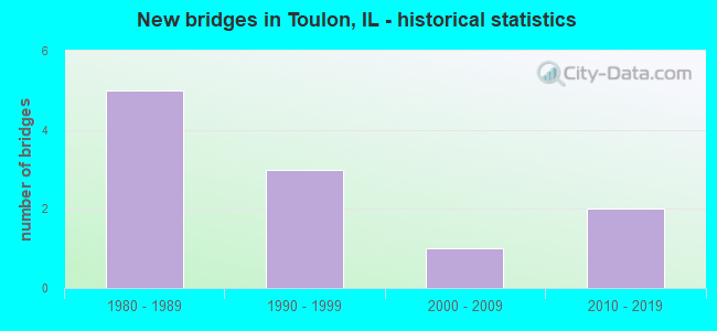
- New bridges - historical statistics
- 51980-1989
- 31990-1999
- 12000-2009
- 22010-2019


- Bridge Condition - Deck
- 33.3%Very good
- 55.6%Good
- 11.1%Satisfactory

- Bridge Condition - Superstructure
- 33.3%Very good
- 55.6%Good
- 11.1%Satisfactory

- Bridge Condition - Substructure
- 22.2%Very good
- 55.6%Good
- 22.2%Satisfactory

- Bridge Condition - Channel
- 9.1%Excellent
- 27.3%Very good
- 45.5%Good
- 9.1%Satisfactory
- 9.1%Fair

- Bridge Condition - Culverts
- 50.0%Very good
- 50.0%Satisfactory
Find on map >> Show street view
Structure Number: 880032, Location: 0.5 mi w of Toulon (Lat: 41.097989, Lng: -89.885058), Route carried "on" structure: State highway 17, Year Built: 2018, Status: Open, Structure Length: 3.61m (11.84ft), Average Daily Traffic: 1,100 (year 2021), Truck Traffic: 6%, Average Future Daily Traffic: 1,666 (year 2032), Design Load: HS 25 or greater, Features Intersected: Indian Creek
Minimum Vertical Clearance: 30+ m (98+ ft), Kilometerpoint: 107.421, Lanes on structure: 2, Base Highway Network: Yes, Owner: State Highway Agency, Approaching Roadway Width: 11.0m (36.1ft), Skew: 3 degrees, Material/Design: Prestressed concrete, Design/Construction: Stringer/Multi-beam, Number Of Spans In Main Unit: 1, Length of Maximum Span: 34.7m (113.8ft), Curb-To-Curb Width: 11.0m (36.1ft), Out-to-Out Width: 11.9m (39.0ft)
Condition: Deck: Very good, Superstructure: Very good, Substructure: Very good, Channel: Excellent, Operating Rating: 66.4 metric tons, Method Used To Determine Operating Rating: Load and Resistance Factor Rating (LRFR) rating reported by rating factor(RF) method using HL-93 loadings, Inventory Rating: 51.8 metric tons, Method Used To Determine Inventory Rating: Load and Resistance Factor Rating (LRFR) rating reported by rating factor(RF) method using HL-93 loadings, Structural Evaluation: Equal to present desirable criteria, Deck Geometry: Equal to present minimum criteria, Waterway Adequacy: Superior to present desirable criteria, Approach Roadway Alignment: Equal to present minimum criteria, Designated Inspection Frequency: Every 24 months, Inspection Date: March 2021, Deck Structure Type: Concrete Cast-file-Place, Wearing Surface/Protective System: Deck Protection: Epoxy Coated Reinforcing
Find on map >> Show street view
Structure Number: 882002, Location: 3 MI N OF W JERSEY (Lat: 41.058036, Lng: -89.926614), Route carried "on" structure: State highway 78, Year Built: 2002, Status: Open, Structure Length: 0.72m (2.36ft), Average Daily Traffic: 2,150 (year 2021), Truck Traffic: 17%, Average Future Daily Traffic: 2,446 (year 2032), Design Load: HS 20, Features Intersected: WALNUT CR TRIB
Minimum Vertical Clearance: 30+ m (98+ ft), Kilometerpoint: 169.459, Lanes on structure: 2, Base Highway Network: Yes, Owner: State Highway Agency, Approaching Roadway Width: 9.8m (32.2ft), Skew: 3 degrees, Material/Design: Concrete, Design/Construction: Culvert, Number Of Spans In Main Unit: 2, Length of Maximum Span: 3.0m (9.8ft)
Condition: Channel: Fair, Culverts: Satisfactory, Operating Rating: 44.1 metric tons, Method Used To Determine Operating Rating: Load Factor (LF) rating reported by rating factor (RF) method using MS18 loading, Inventory Rating: 32.4 metric tons, Method Used To Determine Inventory Rating: Load Factor (LF) rating reported by rating factor (RF) method using MS18 loading, Structural Evaluation: Equal to present minimum criteria, Waterway Adequacy: Equal to present minimum criteria, Approach Roadway Alignment: Equal to present desirable criteria, Designated Inspection Frequency: Every 24 months, Inspection Date: September 2021
Find on map >> Show street view
Structure Number: 883206, Location: NE-36-T13NR5E (Lat: 41.072150, Lng: -89.870775), Route carried "on" structure: County highway , Year Built: 1980, Status: Open, Structure Length: 3.60m (11.81ft), Average Daily Traffic: 250 (year 2018), Truck Traffic: 20%, Average Future Daily Traffic: 364 (year 2032), Design Load: HS 20, Features Intersected: INDIAN CREEK, Facility Carried by Structure: FAS 1376-CH 6
Minimum Vertical Clearance: 30+ m (98+ ft), Kilometerpoint: 2.591, Lanes on structure: 2, Owner: County Highway Agency, Approaching Roadway Width: 9.1m (29.9ft), Material/Design: Prestressed concrete, Design/Construction: Box Beam or Girders - Multiple, Number Of Spans In Main Unit: 3, Length of Maximum Span: 12.2m (40.0ft), Curb-To-Curb Width: 8.5m (27.9ft), Out-to-Out Width: 8.5m (27.9ft)
Condition: Deck: Good, Superstructure: Good, Substructure: Good, Channel: Very good, Operating Rating: 53.8 metric tons, Method Used To Determine Operating Rating: Assigned rating based on Load Factor Design (LFD) reported by rating factor (RF) using MS18 loading, Inventory Rating: 32.4 metric tons, Method Used To Determine Inventory Rating: Assigned rating based on Load Factor Design (LFD) reported by rating factor (RF) using MS18 loading, Structural Evaluation: Better than present minimum criteria, Deck Geometry: Equal to present minimum criteria, Waterway Adequacy: Equal to present desirable criteria, Approach Roadway Alignment: Equal to present minimum criteria, Designated Inspection Frequency: Every 24 months, Inspection Date: November 2019, Deck Structure Type: Concrete Precast Panels, Wearing Surface/Protective System: Wearing Surface: Bituminous
Find on map >> Show street view
Structure Number: 884421, Location: E.CTR-31-T14NR6E (Lat: 41.156533, Lng: -89.852175), Route carried "on" structure: County highway , Year Built: 1985, Status: Open, Structure Length: 1.58m (5.18ft), Average Daily Traffic: 50 (year 2018), Average Future Daily Traffic: 52 (year 2032), Design Load: HS 20, Features Intersected: JACK CREEK, Facility Carried by Structure: TR 49
Minimum Vertical Clearance: 30+ m (98+ ft), Kilometerpoint: 0.595, Lanes on structure: 2, Owner: Town or Township Highway Agency, Approaching Roadway Width: 7.3m (24.0ft), Skew: 1 degrees, Material/Design: Prestressed concrete, Design/Construction: Box Beam or Girders - Multiple, Number Of Spans In Main Unit: 1, Length of Maximum Span: 14.9m (48.9ft), Curb-To-Curb Width: 8.5m (27.9ft), Out-to-Out Width: 8.5m (27.9ft)
Condition: Deck: Very good, Superstructure: Very good, Substructure: Good, Channel: Satisfactory, Operating Rating: 53.8 metric tons, Method Used To Determine Operating Rating: Assigned rating based on Load Factor Design (LFD) reported by rating factor (RF) using MS18 loading, Inventory Rating: 32.4 metric tons, Method Used To Determine Inventory Rating: Assigned rating based on Load Factor Design (LFD) reported by rating factor (RF) using MS18 loading, Structural Evaluation: Better than present minimum criteria, Deck Geometry: Better than present minimum criteria, Waterway Adequacy: Equal to present desirable criteria, Approach Roadway Alignment: Equal to present desirable criteria, Designated Inspection Frequency: Every 48 months, Inspection Date: Febuary 2018, Deck Structure Type: Concrete Precast Panels
Find on map >> Show street view
Structure Number: 884603, Location: E.CTR-8-T12NR6E (Lat: 41.040561, Lng: -89.834628), Route carried "on" structure: County highway , Year Built: 1995, Status: Open, Structure Length: 3.65m (11.98ft), Average Daily Traffic: 50 (year 2018), Average Future Daily Traffic: 104 (year 2032), Design Load: HS 20, Features Intersected: INDIAN CREEK, Facility Carried by Structure: TR 141
Minimum Vertical Clearance: 30+ m (98+ ft), Kilometerpoint: 2.832, Lanes on structure: 2, Owner: Town or Township Highway Agency, Approaching Roadway Width: 5.5m (18.0ft), Skew: 2 degrees, Material/Design: Prestressed concrete, Design/Construction: Box Beam or Girders - Multiple, Number Of Spans In Main Unit: 3, Length of Maximum Span: 14.7m (48.2ft), Curb-To-Curb Width: 7.3m (24.0ft), Out-to-Out Width: 7.3m (24.0ft)
Condition: Deck: Very good, Superstructure: Very good, Substructure: Very good, Channel: Good, Operating Rating: 44.1 metric tons, Method Used To Determine Operating Rating: Assigned rating based on Load Factor Design (LFD) reported by rating factor (RF) using MS18 loading, Inventory Rating: 32.4 metric tons, Method Used To Determine Inventory Rating: Assigned rating based on Load Factor Design (LFD) reported by rating factor (RF) using MS18 loading, Structural Evaluation: Equal to present desirable criteria, Deck Geometry: Equal to present minimum criteria, Waterway Adequacy: Equal to present desirable criteria, Approach Roadway Alignment: Equal to present desirable criteria, Designated Inspection Frequency: Every 48 months, Inspection Date: April 2018, Deck Structure Type: Concrete Precast Panels
Find on map >> Show street view
Structure Number: 884803, Location: NE COR-11-T13NR5E (Lat: 41.135150, Lng: -89.892236), Route carried "on" structure: County highway , Year Built: 1984, Status: Open, Structure Length: 3.41m (11.19ft), Average Daily Traffic: 75 (year 2018), Truck Traffic: 13%, Average Future Daily Traffic: 104 (year 2032), Design Load: HS 20, Features Intersected: BR INDIAN CREEK, Facility Carried by Structure: TR 63
Minimum Vertical Clearance: 30+ m (98+ ft), Kilometerpoint: 7.660, Lanes on structure: 2, Owner: Town or Township Highway Agency, Approaching Roadway Width: 7.9m (25.9ft), Skew: 1 degrees, Material/Design: Prestressed concrete, Design/Construction: Box Beam or Girders - Multiple, Number Of Spans In Main Unit: 3, Length of Maximum Span: 18.3m (60.0ft), Curb-To-Curb Width: 8.5m (27.9ft), Out-to-Out Width: 8.5m (27.9ft)
Condition: Deck: Good, Superstructure: Good, Substructure: Good, Channel: Very good, Operating Rating: 53.8 metric tons, Method Used To Determine Operating Rating: Assigned rating based on Load Factor Design (LFD) reported by rating factor (RF) using MS18 loading, Inventory Rating: 32.4 metric tons, Method Used To Determine Inventory Rating: Assigned rating based on Load Factor Design (LFD) reported by rating factor (RF) using MS18 loading, Structural Evaluation: Better than present minimum criteria, Deck Geometry: Better than present minimum criteria, Waterway Adequacy: Equal to present desirable criteria, Approach Roadway Alignment: Equal to present desirable criteria, Designated Inspection Frequency: Every 48 months, Inspection Date: March 2018, Deck Structure Type: Concrete Precast Panels
Find on map >> Show street view
Structure Number: 884805, Location: NW-2-T13NR5E (Lat: 41.146858, Lng: -89.903483), Route carried "on" structure: County highway , Year Built: 1995, Status: Open, Structure Length: 3.71m (12.17ft), Average Daily Traffic: 50 (year 2018), Average Future Daily Traffic: 78 (year 2032), Design Load: HS 20, Features Intersected: INDIAN CREEK, Facility Carried by Structure: TR 57
Minimum Vertical Clearance: 30+ m (98+ ft), Kilometerpoint: 1.867, Lanes on structure: 2, Owner: Town or Township Highway Agency, Approaching Roadway Width: 5.5m (18.0ft), Skew: 1 degrees, Material/Design: Prestressed concrete, Design/Construction: Box Beam or Girders - Multiple, Number Of Spans In Main Unit: 1, Number Of Approach Spans: 2, Length of Maximum Span: 18.3m (60.0ft), Curb-To-Curb Width: 8.5m (27.9ft), Out-to-Out Width: 8.5m (27.9ft)
Condition: Deck: Good, Superstructure: Good, Substructure: Satisfactory, Channel: Good, Operating Rating: 53.8 metric tons, Method Used To Determine Operating Rating: Assigned rating based on Load Factor Design (LFD) reported by rating factor (RF) using MS18 loading, Inventory Rating: 32.4 metric tons, Method Used To Determine Inventory Rating: Assigned rating based on Load Factor Design (LFD) reported by rating factor (RF) using MS18 loading, Structural Evaluation: Equal to present minimum criteria, Deck Geometry: Better than present minimum criteria, Waterway Adequacy: Better than present minimum criteria, Approach Roadway Alignment: Equal to present desirable criteria, Designated Inspection Frequency: Every 24 months, Inspection Date: March 2020, Deck Structure Type: Concrete Precast Panels
Find on map >> Show street view
Structure Number: 884811, Location: NE COR-25-T13NR5E (Lat: 41.091344, Lng: -89.876336), Route carried "on" structure: County highway , Year Built: 1986, Status: Open, Structure Length: 3.26m (10.70ft), Average Daily Traffic: 75 (year 2018), Truck Traffic: 13%, Average Future Daily Traffic: 78 (year 2032), Design Load: HS 20, Features Intersected: INDIAN CREEK, Facility Carried by Structure: TR 99
Minimum Vertical Clearance: 30+ m (98+ ft), Kilometerpoint: 1.110, Lanes on structure: 2, Owner: Town or Township Highway Agency, Approaching Roadway Width: 8.5m (27.9ft), Skew: 2 degrees, Material/Design: Prestressed concrete, Design/Construction: Box Beam or Girders - Multiple, Number Of Spans In Main Unit: 3, Length of Maximum Span: 10.7m (35.1ft), Curb-To-Curb Width: 8.5m (27.9ft), Out-to-Out Width: 8.5m (27.9ft)
Condition: Deck: Good, Superstructure: Good, Substructure: Good, Channel: Good, Operating Rating: 53.8 metric tons, Method Used To Determine Operating Rating: Assigned rating based on Load Factor Design (LFD) reported by rating factor (RF) using MS18 loading, Inventory Rating: 32.4 metric tons, Method Used To Determine Inventory Rating: Assigned rating based on Load Factor Design (LFD) reported by rating factor (RF) using MS18 loading, Structural Evaluation: Better than present minimum criteria, Deck Geometry: Better than present minimum criteria, Waterway Adequacy: Equal to present minimum criteria, Approach Roadway Alignment: Equal to present desirable criteria, Designated Inspection Frequency: Every 24 months, Inspection Date: March 2020, Deck Structure Type: Concrete Precast Panels, Wearing Surface/Protective System: Wearing Surface: Gravel
Find on map >> Show street view
Structure Number: 884813, Location: 900N 580E (Lat: 41.105839, Lng: -89.872625), Route carried "on" structure: County highway , Year Built: 2017, Status: Open, Structure Length: 0.78m (2.56ft), Average Daily Traffic: 75 (year 2018), Truck Traffic: 17%, Average Future Daily Traffic: 75 (year 2042), Design Load: HS 25 or greater, Features Intersected: Trib to Indian Creek, Facility Carried by Structure: TR-85 (Vineyard Rd
Minimum Vertical Clearance: 30+ m (98+ ft), Kilometerpoint: 0.837, Lanes on structure: 2, Owner: Town or Township Highway Agency, Approaching Roadway Width: 8.5m (27.9ft), Skew: 1 degrees, Material/Design: Aluminum, Iron, Design/Construction: Culvert, Number Of Spans In Main Unit: 1, Length of Maximum Span: 7.8m (25.6ft)
Condition: Channel: Very good, Culverts: Very good, Operating Rating: 42.1 metric tons, Method Used To Determine Operating Rating: Assigned ratings based on Load and Resistance Factor Design (LRFD) reported by rating factor (RF) using HL93 loadings, Inventory Rating: 32.4 metric tons, Method Used To Determine Inventory Rating: Assigned ratings based on Load and Resistance Factor Design (LRFD) reported by rating factor (RF) using HL93 loadings, Structural Evaluation: Equal to present desirable criteria, Waterway Adequacy: Equal to present desirable criteria, Approach Roadway Alignment: Equal to present desirable criteria, Designated Inspection Frequency: Every 24 months, Inspection Date: May 2020, Wearing Surface/Protective System: Wearing Surface: Gravel
Find on map >> Show street view
Structure Number: 885403, Location: NW-4-T13NR6E (Lat: 41.147731, Lng: -89.823997), Route carried "on" structure: County highway , Year Built: 1994, Status: Open, Structure Length: 3.71m (12.17ft), Average Daily Traffic: 50 (year 2018), Average Future Daily Traffic: 52 (year 2032), Design Load: HS 20, Features Intersected: JACK CREEK, Facility Carried by Structure: TR 62
Minimum Vertical Clearance: 30+ m (98+ ft), Kilometerpoint: 5.230, Lanes on structure: 2, Owner: Town or Township Highway Agency, Approaching Roadway Width: 5.5m (18.0ft), Skew: 2 degrees, Material/Design: Prestressed concrete, Design/Construction: Box Beam or Girders - Multiple, Number Of Spans In Main Unit: 3, Length of Maximum Span: 18.3m (60.0ft), Curb-To-Curb Width: 8.5m (27.9ft), Out-to-Out Width: 8.5m (27.9ft)
Condition: Deck: Good, Superstructure: Good, Substructure: Good, Channel: Good, Operating Rating: 53.8 metric tons, Method Used To Determine Operating Rating: Assigned rating based on Load Factor Design (LFD) reported by rating factor (RF) using MS18 loading, Inventory Rating: 32.4 metric tons, Method Used To Determine Inventory Rating: Assigned rating based on Load Factor Design (LFD) reported by rating factor (RF) using MS18 loading, Structural Evaluation: Better than present minimum criteria, Deck Geometry: Better than present minimum criteria, Waterway Adequacy: Equal to present desirable criteria, Approach Roadway Alignment: Equal to present desirable criteria, Designated Inspection Frequency: Every 24 months, Inspection Date: May 2020, Deck Structure Type: Concrete Precast Panels, Wearing Surface/Protective System: Wearing Surface: Gravel
Find on map >> Show street view
Structure Number: 885407, Location: CTR-31-T13NR6E (Lat: 41.072650, Lng: -89.859608), Route carried "on" structure: County highway , Year Built: 1982, Status: Open, Structure Length: 3.92m (12.86ft), Average Daily Traffic: 125 (year 2018), Truck Traffic: 26%, Average Future Daily Traffic: 156 (year 2032), Design Load: HS 20, Features Intersected: INDIAN CREEK, Facility Carried by Structure: TR 46
Minimum Vertical Clearance: 30+ m (98+ ft), Kilometerpoint: 1.979, Lanes on structure: 2, Owner: Town or Township Highway Agency, Approaching Roadway Width: 7.3m (24.0ft), Skew: 3 degrees, Material/Design: Prestressed concrete, Design/Construction: Box Beam or Girders - Multiple, Number Of Spans In Main Unit: 3, Length of Maximum Span: 13.1m (43.0ft), Curb-To-Curb Width: 8.5m (27.9ft), Out-to-Out Width: 8.5m (27.9ft)
Condition: Deck: Satisfactory, Superstructure: Satisfactory, Substructure: Satisfactory, Channel: Good, Operating Rating: 62.5 metric tons, Method Used To Determine Operating Rating: Load Factor (LF) rating reported by rating factor (RF) method using MS18 loading, Inventory Rating: 37.3 metric tons, Method Used To Determine Inventory Rating: Load Factor (LF) rating reported by rating factor (RF) method using MS18 loading, Structural Evaluation: Equal to present minimum criteria, Deck Geometry: Equal to present minimum criteria, Waterway Adequacy: Better than present minimum criteria, Approach Roadway Alignment: Equal to present desirable criteria, Designated Inspection Frequency: Every 24 months, Inspection Date: May 2020, Deck Structure Type: Concrete Precast Panels, Wearing Surface/Protective System: Wearing Surface: Gravel