Bridge Statistics for Tok, Alaska (AK)
Condition, Traffic, Stress, Structural Evaluation, Project Costs
- National Bridge Inventory (NBI) Statistics
- 16Number of bridges
- 482ft / 147mTotal length
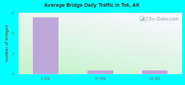
- 37,203Total average daily traffic
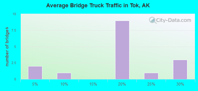
- 1,765Total average daily truck traffic
- 71,390Total future (year 2035) average daily traffic
- National Bridge Inventory (NBI) Registered Bridges for Tok
- No street view available for this location
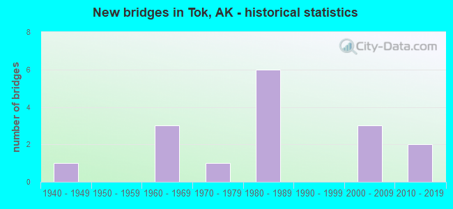
- New bridges - historical statistics
- 11940-1949
- 31960-1969
- 11970-1979
- 61980-1989
- 32000-2009
- 22010-2019
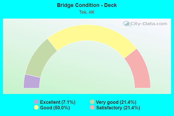
- Bridge Condition - Deck
- 7.1%Excellent
- 21.4%Very good
- 50.0%Good
- 21.4%Satisfactory
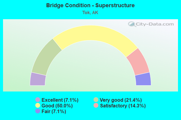
- Bridge Condition - Superstructure
- 7.1%Excellent
- 21.4%Very good
- 50.0%Good
- 14.3%Satisfactory
- 7.1%Fair
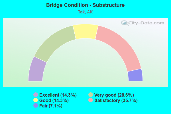
- Bridge Condition - Substructure
- 14.3%Excellent
- 28.6%Very good
- 14.3%Good
- 35.7%Satisfactory
- 7.1%Fair
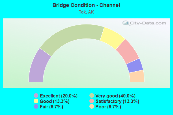
- Bridge Condition - Channel
- 20.0%Excellent
- 40.0%Very good
- 13.3%Good
- 13.3%Satisfactory
- 6.7%Fair
- 6.7%Poor
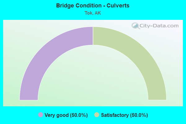
- Bridge Condition - Culverts
- 50.0%Very good
- 50.0%Satisfactory
Find on map >> Show street view
Structure Number: 19, Location: KETCHIKAN (Lat: 55.354047, Lng: -131.691897), Route carried "on" structure: State highway , Year Built: 2003, Status: Open, Structure Length: 4.36m (14.30ft), Average Daily Traffic: 50 (year 2018), Truck Traffic: 1%, Average Future Daily Traffic: 60 (year 2035), Design Load: HS 20+Mod, Features Intersected: KETCHIKAN TRANSFER FAC, Facility Carried by Structure: INTER ISLAND RTE
Minimum Vertical Clearance: 30+ m (98+ ft), Kilometerpoint: 0.161, Lanes on structure: 1, Toll: On toll road, Owner: State Highway Agency, Approaching Roadway Width: 3.7m (12.1ft), Material/Design: Steel, Design/Construction: Box Beam or Girders - Multiple, Number Of Spans In Main Unit: 1, Length of Maximum Span: 42.7m (140.1ft), Curb or Sidewalk Widths: Left: 0.0m, Right: 1.8m (5.9ft), Curb-To-Curb Width: 4.1m (13.5ft), Out-to-Out Width: 6.1m (20.0ft)
Condition: Deck: Satisfactory, Superstructure: Good, Substructure: Satisfactory, Channel: Excellent, Operating Rating: 59.8 metric tons, Method Used To Determine Operating Rating: Load Factor (LF), Inventory Rating: 32.7 metric tons, Method Used To Determine Inventory Rating: Load Factor (LF), Structural Evaluation: Equal to present minimum criteria, Deck Geometry: Somewhat better than minimum adequacy, Waterway Adequacy: Better than present minimum criteria, Approach Roadway Alignment: Equal to present minimum criteria, Designated Inspection Frequency: Every 24 months, Critical Feature Inspection Frequency: Every 24 months, Underwater Inspection Frequency: Every 60 months, Inspection Date: May 2021, Critical Feature Inspection Date: May 2021, Underwater Inspection Date: August 2021, Deck Structure Type: Open Grating, Wearing Surface/Protective System: Deck Protection: Other
Find on map >> Show street view
Structure Number: 348, Location: MILE POINT 7.5 (Lat: 60.520294, Lng: -145.595322), Route carried "on" structure: State highway 851, Year Built: 1966, Status: Open, Structure Length: 4.93m (16.17ft), Average Daily Traffic: 520 (year 2020), Truck Traffic: 17%, Average Future Daily Traffic: 630 (year 2039), Design Load: HS 20+Mod, Features Intersected: SCOTT GLACIER NO 1, Facility Carried by Structure: COPPER RIVER HWY
Minimum Vertical Clearance: 6.10m (20.01ft), Kilometerpoint: 12.131, Lanes on structure: 2, Owner: State Highway Agency, Approaching Roadway Width: 8.2m (26.9ft), Material/Design: Steel, Design/Construction: Stringer/Multi-beam, Number Of Spans In Main Unit: 3, Length of Maximum Span: 18.3m (60.0ft), Curb-To-Curb Width: 8.5m (27.9ft), Out-to-Out Width: 9.0m (29.5ft)
Condition: Deck: Good, Superstructure: Good, Substructure: Good, Channel: Very good, Operating Rating: 63.0 metric tons, Method Used To Determine Operating Rating: Load Factor (LF), Inventory Rating: 29.0 metric tons, Method Used To Determine Inventory Rating: Load Factor (LF), Structural Evaluation: Better than present minimum criteria, Deck Geometry: Somewhat better than minimum adequacy, Waterway Adequacy: Equal to present minimum criteria, Approach Roadway Alignment: Equal to present desirable criteria, Designated Inspection Frequency: Every 24 months, Inspection Date: August 2020, Deck Structure Type: Concrete Cast-file-Place, Wearing Surface/Protective System: Wearing Surface: Monolithic Concrete
Find on map >> Show street view
Structure Number: 505, Location: MILE POINT 79.1 (Lat: 63.317161, Lng: -142.646878), Route carried "on" structure: Interstate A11, Year Built: 2010, Status: Open, Structure Length: 27.51m (90.26ft), Average Daily Traffic: 250 (year 2020), Truck Traffic: 28%, Average Future Daily Traffic: 340 (year 2039), Design Load: HL 93, Features Intersected: TANANA RIVER, Facility Carried by Structure: ALASKA HIGHWAY
Minimum Vertical Clearance: 4.72m (15.49ft), Kilometerpoint: 127.362, Lanes on structure: 2, Base Highway Network: Yes, Owner: State Highway Agency, Approaching Roadway Width: 12.2m (40.0ft), Material/Design: Prestressed concrete, Design/Construction: Tee Beam, Number Of Spans In Main Unit: 6, Length of Maximum Span: 45.7m (149.9ft), Curb-To-Curb Width: 12.2m (40.0ft), Out-to-Out Width: 13.1m (43.0ft)
Condition: Deck: Excellent, Superstructure: Very good, Substructure: Very good, Channel: Excellent, Operating Rating: 87.7 metric tons, Method Used To Determine Operating Rating: Load Factor (LF), Inventory Rating: 40.4 metric tons, Method Used To Determine Inventory Rating: Load Factor (LF), Structural Evaluation: Equal to present desirable criteria, Deck Geometry: Superior to present desirable criteria, Waterway Adequacy: Equal to present desirable criteria, Approach Roadway Alignment: Equal to present minimum criteria, Designated Inspection Frequency: Every 24 months, Underwater Inspection Frequency: Every 60 months, Inspection Date: July 2020, Underwater Inspection Date: September 2020, Deck Structure Type: Other, Wearing Surface/Protective System: Wearing Surface: Bituminous, Membrane: Preformed Fabric, Deck Protection: Epoxy Coated Reinforcing
Find on map >> Show street view
Structure Number: 506, Location: MILE POINT 85.2 (Lat: 63.324994, Lng: -142.836092), Route carried "on" structure: State highway A11, Year Built: 2019, Status: Open, Structure Length: 10.97m (35.99ft), Average Daily Traffic: 400 (year 2020), Truck Traffic: 22%, Average Future Daily Traffic: 650 (year 2039), Design Load: HL 93, Features Intersected: TOK RIVER, Facility Carried by Structure: ALASKA HIGHWAY
Minimum Vertical Clearance: 30+ m (98+ ft), Kilometerpoint: 137.116, Lanes on structure: 2, Base Highway Network: Yes, Owner: State Highway Agency, Approaching Roadway Width: 12.2m (40.0ft), Skew: 3 degrees, Material/Design: Prestressed concrete, Design/Construction: Tee Beam, Number Of Spans In Main Unit: 3, Length of Maximum Span: 36.6m (120.1ft), Curb-To-Curb Width: 12.2m (40.0ft), Out-to-Out Width: 13.1m (43.0ft)
Condition: Deck: Very good, Superstructure: Very good, Substructure: Excellent, Channel: Very good, Operating Rating: 87.7 metric tons, Method Used To Determine Operating Rating: Load Factor (LF), Inventory Rating: 40.4 metric tons, Method Used To Determine Inventory Rating: Load Factor (LF), Structural Evaluation: Equal to present desirable criteria, Deck Geometry: Superior to present desirable criteria, Waterway Adequacy: Superior to present desirable criteria, Approach Roadway Alignment: Superior to present desirable criteria, Designated Inspection Frequency: Every 24 months, Inspection Date: July 2020, Deck Structure Type: Other, Wearing Surface/Protective System: Wearing Surface: Bituminous, Membrane: Preformed Fabric, Deck Protection: Epoxy Coated Reinforcing
Find on map >> Show street view
Structure Number: 507, Location: MILE POINT 109.5 (Lat: 63.382644, Lng: -143.596306), Route carried "on" structure: Interstate A21, Year Built: 1985, Status: Open, Structure Length: 6.16m (20.21ft), Average Daily Traffic: 230 (year 2020), Truck Traffic: 19%, Average Future Daily Traffic: 600 (year 2039), Design Load: HS 20, Features Intersected: YERRICK CREEK, Facility Carried by Structure: ALASKA HIGHWAY
Minimum Vertical Clearance: 4.72m (15.49ft), Kilometerpoint: 176.263, Lanes on structure: 2, Base Highway Network: Yes, Owner: State Highway Agency, Approaching Roadway Width: 11.3m (37.1ft), Material/Design: Prestressed concrete, Design/Construction: Tee Beam, Number Of Spans In Main Unit: 2, Length of Maximum Span: 30.5m (100.1ft), Curb-To-Curb Width: 11.0m (36.1ft), Out-to-Out Width: 11.3m (37.1ft)
Condition: Deck: Good, Superstructure: Satisfactory, Substructure: Satisfactory, Channel: Fair, Operating Rating: 81.6 metric tons, Method Used To Determine Operating Rating: Load Factor (LF), Inventory Rating: 39.8 metric tons, Method Used To Determine Inventory Rating: Load Factor (LF), Structural Evaluation: Equal to present minimum criteria, Deck Geometry: Equal to present desirable criteria, Waterway Adequacy: Better than present minimum criteria, Approach Roadway Alignment: Equal to present desirable criteria, Designated Inspection Frequency: Every 24 months, Inspection Date: July 2020, Deck Structure Type: Other, Wearing Surface/Protective System: Wearing Surface: Bituminous
Find on map >> Show street view
Structure Number: 508, Location: MILE POINT 114.1 (Lat: 63.385936, Lng: -143.736544), Route carried "on" structure: Interstate A21, Year Built: 1985, Status: Open, Structure Length: 2.07m (6.79ft), Average Daily Traffic: 230 (year 2020), Truck Traffic: 19%, Average Future Daily Traffic: 600 (year 2039), Design Load: HS 20, Features Intersected: CATHEDRAL RAPIDS NO 1, Facility Carried by Structure: ALASKA HIGHWAY
Minimum Vertical Clearance: 4.72m (15.49ft), Kilometerpoint: 183.557, Lanes on structure: 2, Base Highway Network: Yes, Owner: State Highway Agency, Approaching Roadway Width: 11.0m (36.1ft), Material/Design: Prestressed concrete, Design/Construction: Tee Beam, Number Of Spans In Main Unit: 1, Length of Maximum Span: 20.1m (65.9ft), Curb-To-Curb Width: 11.2m (36.7ft), Out-to-Out Width: 11.6m (38.1ft)
Condition: Deck: Good, Superstructure: Good, Substructure: Very good, Channel: Good, Operating Rating: 75.2 metric tons, Method Used To Determine Operating Rating: Load Factor (LF), Inventory Rating: 34.4 metric tons, Method Used To Determine Inventory Rating: Load Factor (LF), Structural Evaluation: Better than present minimum criteria, Deck Geometry: Superior to present desirable criteria, Waterway Adequacy: Equal to present minimum criteria, Approach Roadway Alignment: Equal to present desirable criteria, Designated Inspection Frequency: Every 24 months, Inspection Date: July 2020, Deck Structure Type: Other, Wearing Surface/Protective System: Wearing Surface: Bituminous
Find on map >> Show street view
Structure Number: 509, Location: MILE POINT 123.2 (Lat: 63.497186, Lng: -143.833864), Route carried "on" structure: Interstate A21, Year Built: 1944, Status: Open, Structure Length: 60.32m (197.90ft), Average Daily Traffic: 230 (year 2020), Truck Traffic: 19%, Average Future Daily Traffic: 600 (year 2039), Design Load: HS 15, Features Intersected: ROBERTSON RIVER, Facility Carried by Structure: ALASKA HIGHWAY
Minimum Vertical Clearance: 4.72m (15.49ft), Kilometerpoint: 198.252, Lanes on structure: 2, Base Highway Network: Yes, Owner: State Highway Agency, Approaching Roadway Width: 10.7m (35.1ft), Material/Design: Steel, Design/Construction: Truss - Deck, Number Of Spans In Main Unit: 9, Number Of Approach Spans: 3, Length of Maximum Span: 61.0m (200.1ft), Curb-To-Curb Width: 7.2m (23.6ft), Out-to-Out Width: 8.5m (27.9ft)
Condition: Deck: Satisfactory, Superstructure: Good, Substructure: Satisfactory, Channel: Good, Operating Rating: 51.1 metric tons, Method Used To Determine Operating Rating: Load Factor (LF), Inventory Rating: 27.8 metric tons, Method Used To Determine Inventory Rating: Load Factor (LF), Structural Evaluation: Equal to present minimum criteria, Deck Geometry: Meets minimum limits, Waterway Adequacy: Superior to present desirable criteria, Approach Roadway Alignment: Equal to present minimum criteria, Designated Inspection Frequency: Every 24 months, Critical Feature Inspection Frequency: Every 24 months, Inspection Date: July 2020, Critical Feature Inspection Date: July 2021, Deck Structure Type: Concrete Cast-file-Place, Wearing Surface/Protective System: Wearing Surface: Monolithic Concrete
Find on map >> Show street view
Structure Number: 511, Location: MILE POINT 114.9 (Lat: 63.388025, Lng: -143.763639), Route carried "on" structure: Interstate A21, Year Built: 1985, Status: Open, Structure Length: 2.07m (6.79ft), Average Daily Traffic: 230 (year 2020), Truck Traffic: 19%, Average Future Daily Traffic: 600 (year 2039), Design Load: HS 20, Features Intersected: CATHEDRAL RAPIDS NO 3, Facility Carried by Structure: ALASKA HIGHWAY
Minimum Vertical Clearance: 4.72m (15.49ft), Kilometerpoint: 184.935, Lanes on structure: 2, Base Highway Network: Yes, Owner: State Highway Agency, Approaching Roadway Width: 11.0m (36.1ft), Material/Design: Prestressed concrete, Design/Construction: Tee Beam, Number Of Spans In Main Unit: 1, Length of Maximum Span: 20.1m (65.9ft), Curb-To-Curb Width: 10.9m (35.8ft), Out-to-Out Width: 11.2m (36.7ft)
Condition: Deck: Very good, Superstructure: Very good, Substructure: Very good, Channel: Very good, Operating Rating: 75.2 metric tons, Method Used To Determine Operating Rating: Load Factor (LF), Inventory Rating: 34.4 metric tons, Method Used To Determine Inventory Rating: Load Factor (LF), Structural Evaluation: Equal to present desirable criteria, Deck Geometry: Better than present minimum criteria, Waterway Adequacy: Equal to present minimum criteria, Approach Roadway Alignment: Equal to present desirable criteria, Designated Inspection Frequency: Every 24 months, Inspection Date: July 2020, Deck Structure Type: Other, Wearing Surface/Protective System: Wearing Surface: Bituminous
Find on map >> Show street view
Structure Number: 513, Location: MILE POINT 133.2 (Lat: 63.615028, Lng: -143.986211), Route carried "on" structure: Interstate A21, Year Built: 1985, Status: Open, Structure Length: 1.68m (5.51ft), Average Daily Traffic: 230 (year 2020), Truck Traffic: 19%, Average Future Daily Traffic: 600 (year 2039), Design Load: HS 20, Features Intersected: BEAR CREEK, Facility Carried by Structure: ALASKA HIGHWAY
Minimum Vertical Clearance: 4.72m (15.49ft), Kilometerpoint: 214.363, Lanes on structure: 2, Base Highway Network: Yes, Owner: State Highway Agency, Approaching Roadway Width: 11.0m (36.1ft), Material/Design: Prestressed concrete, Design/Construction: Tee Beam, Number Of Spans In Main Unit: 1, Length of Maximum Span: 16.8m (55.1ft), Curb-To-Curb Width: 11.0m (36.1ft), Out-to-Out Width: 11.3m (37.1ft)
Condition: Deck: Good, Superstructure: Good, Substructure: Good, Channel: Satisfactory, Inventory Rating: 48.2 metric tons, Method Used To Determine Inventory Rating: Load Factor (LF), Structural Evaluation: Better than present minimum criteria, Deck Geometry: Equal to present desirable criteria, Waterway Adequacy: Equal to present minimum criteria, Approach Roadway Alignment: Equal to present desirable criteria, Designated Inspection Frequency: Every 24 months, Inspection Date: July 2020, Deck Structure Type: Other, Wearing Surface/Protective System: Wearing Surface: Bituminous, Membrane: Preformed Fabric
Find on map >> Show street view
Structure Number: 514, Location: MILE POINT 134.6 (Lat: 63.630700, Lng: -144.013697), Route carried "on" structure: Interstate A21, Year Built: 1985, Status: Open, Structure Length: 1.25m (4.10ft), Average Daily Traffic: 190 (year 2020), Truck Traffic: 26%, Average Future Daily Traffic: 260 (year 2039), Design Load: HS 20, Features Intersected: CHIEF CREEK, Facility Carried by Structure: ALASKA HIGHWAY
Minimum Vertical Clearance: 4.72m (15.49ft), Kilometerpoint: 216.579, Lanes on structure: 2, Base Highway Network: Yes, Owner: State Highway Agency, Approaching Roadway Width: 11.3m (37.1ft), Material/Design: Prestressed concrete, Design/Construction: Tee Beam, Number Of Spans In Main Unit: 1, Length of Maximum Span: 12.2m (40.0ft), Curb-To-Curb Width: 9.8m (32.2ft), Out-to-Out Width: 11.2m (36.7ft)
Condition: Deck: Good, Superstructure: Satisfactory, Substructure: Very good, Channel: Very good, Operating Rating: 89.9 metric tons, Method Used To Determine Operating Rating: Load Factor (LF), Inventory Rating: 41.5 metric tons, Method Used To Determine Inventory Rating: Load Factor (LF), Structural Evaluation: Equal to present minimum criteria, Deck Geometry: Better than present minimum criteria, Waterway Adequacy: Equal to present minimum criteria, Approach Roadway Alignment: Equal to present desirable criteria, Designated Inspection Frequency: Every 24 months, Inspection Date: July 2020, Deck Structure Type: Other, Wearing Surface/Protective System: Wearing Surface: Bituminous, Membrane: Preformed Fabric
Find on map >> Show street view
Structure Number: 7, Location: MILE POINT 1.9 (Lat: 61.173056, Lng: -149.910556), Route carried "on" structure: State highway 538, Year Built: 1973, Status: Open, Structure Length: 4.57m (14.99ft), Average Daily Traffic: 12,800 (year 2020), Truck Traffic: 5%, Average Future Daily Traffic: 28,900 (year 2039), Design Load: HS 25 or greater, Features Intersected: INTL AIRPORT RD OVERHEAD, Facility Carried by Structure: INTL AIRPORT RD
Minimum Vertical Clearance: 30+ m (98+ ft), Kilometerpoint: 3.042, Lanes on structure: 4, Owner: State Highway Agency, Approaching Roadway Width: 17.1m (56.1ft), Skew: 1 degrees, Material/Design: Prestressed concrete, Design/Construction: Box Beam or Girders - Multiple, Number Of Spans In Main Unit: 3, Length of Maximum Span: 15.2m (49.9ft), Curb-To-Curb Width: 23.8m (78.1ft), Out-to-Out Width: 28.4m (93.2ft)
Condition: Deck: Good, Superstructure: Good, Substructure: Satisfactory, Operating Rating: 57.3 metric tons, Method Used To Determine Operating Rating: Load Factor (LF), Inventory Rating: 26.5 metric tons, Method Used To Determine Inventory Rating: Load Factor (LF), Structural Evaluation: Equal to present minimum criteria, Deck Geometry: Superior to present desirable criteria, Underclear: Better than present minimum criteria, Approach Roadway Alignment: Better than present minimum criteria, Designated Inspection Frequency: Every 24 months, Inspection Date: August 2021, Deck Structure Type: Other, Wearing Surface/Protective System: Wearing Surface: Bituminous, Membrane: Preformed Fabric, Deck Protection: Epoxy Coated Reinforcing
Find on map >> Show street view
Structure Number: 1474, Location: AUKE BAY (Lat: 58.381611, Lng: -134.684992), Route carried "on" structure: State highway 93, Year Built: 1982, Status: Open, Structure Length: 5.12m (16.80ft), Average Daily Traffic: 53 (year 2018), Truck Traffic: 26%, Average Future Daily Traffic: 80 (year 2035), Design Load: HS 20, Features Intersected: AUKE BAY F.T. - EAST, Facility Carried by Structure: MARINE HWY ROUTE
Minimum Vertical Clearance: 30+ m (98+ ft), Kilometerpoint: 0.113, Lanes on structure: 1, Base Highway Network: Yes, Toll: On toll road, Owner: State Highway Agency, Approaching Roadway Width: 7.3m (24.0ft), Material/Design: Steel, Design/Construction: Box Beam or Girders - Multiple, Number Of Spans In Main Unit: 1, Length of Maximum Span: 42.7m (140.1ft), Curb-To-Curb Width: 4.9m (16.1ft), Out-to-Out Width: 4.9m (16.1ft)
Condition: Deck: Satisfactory, Superstructure: Fair, Substructure: Fair, Channel: Poor, Operating Rating: 64.0 metric tons, Method Used To Determine Operating Rating: Load Factor (LF), Inventory Rating: 29.8 metric tons, Method Used To Determine Inventory Rating: Load Factor (LF), Structural Evaluation: Somewhat better than minimum adequacy, Deck Geometry: High priority of corrective action, Waterway Adequacy: Superior to present desirable criteria, Approach Roadway Alignment: Better than present minimum criteria, Designated Inspection Frequency: Every 24 months, Critical Feature Inspection Frequency: Every 24 months, Underwater Inspection Frequency: Every 60 months, Inspection Date: May 2021, Critical Feature Inspection Date: May 2021, Underwater Inspection Date: August 2021, Deck Structure Type: Open Grating, Wearing Surface/Protective System: Deck Protection: Other
Find on map >> Show street view
Structure Number: 2102, Location: MILE POINT 110 (Lat: 63.160700, Lng: -143.193700), Route carried "on" structure: Interstate A12, Year Built: 2006, Status: Open, Structure Length: 3.20m (10.50ft), Average Daily Traffic: 330 (year 2020), Truck Traffic: 19%, Average Future Daily Traffic: 490 (year 2039), Design Load: HL 93, Features Intersected: CLEARWATER CREEK, Facility Carried by Structure: TOK CUTOFF
Minimum Vertical Clearance: 30+ m (98+ ft), Kilometerpoint: 177.027, Lanes on structure: 2, Base Highway Network: Yes, Owner: State Highway Agency, Approaching Roadway Width: 12.2m (40.0ft), Skew: 1 degrees, Material/Design: Prestressed concrete, Design/Construction: Tee Beam, Number Of Spans In Main Unit: 1, Length of Maximum Span: 31.1m (102.0ft), Curb-To-Curb Width: 12.2m (40.0ft), Out-to-Out Width: 13.1m (43.0ft)
Condition: Deck: Very good, Superstructure: Excellent, Substructure: Excellent, Channel: Satisfactory, Operating Rating: 88.5 metric tons, Method Used To Determine Operating Rating: Load Factor (LF), Inventory Rating: 40.8 metric tons, Method Used To Determine Inventory Rating: Load Factor (LF), Structural Evaluation: Superior to present desirable criteria, Deck Geometry: Superior to present desirable criteria, Waterway Adequacy: Superior to present desirable criteria, Approach Roadway Alignment: Equal to present desirable criteria, Designated Inspection Frequency: Every 24 months, Inspection Date: July 2021, Deck Structure Type: Other, Wearing Surface/Protective System: Wearing Surface: Bituminous, Membrane: Preformed Fabric, Deck Protection: Epoxy Coated Reinforcing
Find on map >> Show street view
Structure Number: 2152, Location: MILE POINT 3.0 (Lat: 61.175556, Lng: -149.808333), Route carried "on" structure: State highway , Year Built: 2007, Status: Open, Structure Length: 10.91m (35.79ft), Average Daily Traffic: 20,800 (year 2020), Truck Traffic: 2%, Average Future Daily Traffic: 36,000 (year 2039), Design Load: HS 25 or greater, Features Intersected: NORTH FORK CAMPBELL CR, Facility Carried by Structure: ELMORE ROAD
Minimum Vertical Clearance: 30+ m (98+ ft), Kilometerpoint: 4.844, Lanes on structure: 4, Base Highway Network: Yes, Owner: State Highway Agency, Approaching Roadway Width: 25.6m (84.0ft), Skew: 32 degrees, Material/Design: Prestressed concrete, Design/Construction: Tee Beam, Number Of Spans In Main Unit: 3, Length of Maximum Span: 36.6m (120.1ft), Curb or Sidewalk Widths: Left: 0.0m, Right: 3.0m (9.8ft), Curb-To-Curb Width: 20.1m (65.9ft), Out-to-Out Width: 25.4m (83.3ft)
Condition: Deck: Good, Superstructure: Good, Substructure: Satisfactory, Channel: Excellent, Operating Rating: 87.7 metric tons, Method Used To Determine Operating Rating: Load Factor (LF), Inventory Rating: 40.4 metric tons, Method Used To Determine Inventory Rating: Load Factor (LF), Structural Evaluation: Equal to present minimum criteria, Deck Geometry: Better than present minimum criteria, Waterway Adequacy: Superior to present desirable criteria, Approach Roadway Alignment: Equal to present desirable criteria, Designated Inspection Frequency: Every 24 months, Inspection Date: August 2021, Deck Structure Type: Other, Wearing Surface/Protective System: Wearing Surface: Bituminous, Membrane: Preformed Fabric, Deck Protection: Epoxy Coated Reinforcing
Find on map >> Show street view
Structure Number: 4106, Location: MILE POINT 102.2 (Lat: 63.118333, Lng: -143.307222), Route carried "on" structure: Interstate A12, Year Built: 1963, Status: Open, Structure Length: 0.84m (2.76ft), Average Daily Traffic: 330 (year 2020), Truck Traffic: 19%, Average Future Daily Traffic: 490 (year 2039), Design Load: H 20, Features Intersected: TOK RIVER OVERFLOW, Facility Carried by Structure: TOK CUTOFF
Minimum Vertical Clearance: 30+ m (98+ ft), Kilometerpoint: 164.475, Lanes on structure: 2, Base Highway Network: Yes, Owner: State Highway Agency, Approaching Roadway Width: 11.3m (37.1ft), Material/Design: Steel, Design/Construction: Culvert, Number Of Spans In Main Unit: 2, Length of Maximum Span: 3.5m (11.5ft)
Condition: Channel: Very good, Culverts: Very good, Operating Rating: 63.7 metric tons, Method Used To Determine Operating Rating: Load Factor (LF), Inventory Rating: 58.8 metric tons, Method Used To Determine Inventory Rating: Load Factor (LF), Structural Evaluation: Equal to present desirable criteria, Waterway Adequacy: Equal to present desirable criteria, Approach Roadway Alignment: Equal to present desirable criteria, Designated Inspection Frequency: Every 24 months, Inspection Date: July 2021
Find on map >> Show street view
Structure Number: 4107, Location: MILE POINT 102.4 (Lat: 63.118611, Lng: -143.307500), Route carried "on" structure: State highway A12, Year Built: 1963, Status: Open, Structure Length: 0.79m (2.59ft), Average Daily Traffic: 330 (year 2020), Truck Traffic: 19%, Average Future Daily Traffic: 490 (year 2039), Design Load: H 20, Features Intersected: TOK RIVER OVERFLOW NO. 2, Facility Carried by Structure: TOK CUTOFF
Minimum Vertical Clearance: 30+ m (98+ ft), Kilometerpoint: 164.794, Lanes on structure: 2, Base Highway Network: Yes, Owner: State Highway Agency, Approaching Roadway Width: 11.3m (37.1ft), Material/Design: Steel, Design/Construction: Culvert, Number Of Spans In Main Unit: 2, Length of Maximum Span: 3.0m (9.8ft)
Condition: Channel: Very good, Culverts: Satisfactory, Structural Evaluation: Equal to present minimum criteria, Waterway Adequacy: Equal to present desirable criteria, Approach Roadway Alignment: Equal to present desirable criteria, Designated Inspection Frequency: Every 24 months, Inspection Date: July 2021