Bridge Statistics for Timberville, Virginia (VA)
Condition, Traffic, Stress, Structural Evaluation, Project Costs
- National Bridge Inventory (NBI) Statistics
- 17Number of bridges
- 184ft / 56.4mTotal length
- $5,360,000Total costs
- 71,661Total average daily traffic
- 6,276Total average daily truck traffic
- National Bridge Inventory (NBI) Registered Bridges for Timberville
- No street view available for this location
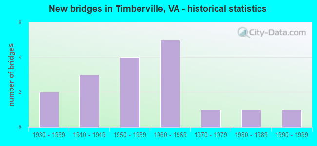
- New bridges - historical statistics
- 21930-1939
- 31940-1949
- 41950-1959
- 51960-1969
- 11970-1979
- 11980-1989
- 11990-1999

- Reconstructed bridges - Historical Statistics
- 11990-1999
- 02000-2009
- 12010-2019


- Bridge Condition - Deck
- 25.0%Very good
- 33.3%Good
- 8.3%Satisfactory
- 16.7%Fair
- 16.7%Poor

- Bridge Condition - Superstructure
- 33.3%Very good
- 8.3%Good
- 16.7%Satisfactory
- 41.7%Fair

- Bridge Condition - Substructure
- 25.0%Very good
- 33.3%Good
- 25.0%Satisfactory
- 16.7%Fair

- Bridge Condition - Channel
- 25.0%Very good
- 25.0%Good
- 33.3%Satisfactory
- 16.7%Fair

- Bridge Condition - Culverts
- 33.3%Good
- 33.3%Satisfactory
- 33.3%Fair
Find on map >> Show street view
Structure Number: 1403, Location: 0.70-Rt.633/2.80-Rockbrig (Lat: 37.773028, Lng: -79.246806), Route carried "on" structure: County highway 605, Year Built: 1937, Status: Posted for load, Structure Length: 1.13m (3.71ft), Average Daily Traffic: 103 (year 2019), Average Future Daily Traffic: 124 (year 2040), Features Intersected: Statons Creek, Facility Carried by Structure: Pedlar River Road
Minimum Vertical Clearance: 30+ m (98+ ft), Kilometerpoint: 4.253, Lanes on structure: 1, Owner: State Highway Agency, Approaching Roadway Width: 3.7m (12.1ft), Material/Design: Steel, Design/Construction: Stringer/Multi-beam, Number Of Spans In Main Unit: 1, Length of Maximum Span: 10.1m (33.1ft), Curb or Sidewalk Widths: Left: 0.2m (0.7ft), Right: 0.2m (0.7ft), Curb-To-Curb Width: 4.3m (14.1ft), Out-to-Out Width: 5.5m (18.0ft)
Condition: Deck: Good, Superstructure: Fair, Substructure: Good, Channel: Satisfactory, Operating Rating: 39.9 metric tons, Method Used To Determine Operating Rating: Load Factor (LF), Inventory Rating: 23.6 metric tons, Method Used To Determine Inventory Rating: Load Factor (LF), Structural Evaluation: Somewhat better than minimum adequacy, Deck Geometry: High priority of replacement, Waterway Adequacy: Somewhat better than minimum adequacy, Approach Roadway Alignment: Equal to present desirable criteria, Length Of Structure Improvement: 1.83m (6.00ft), Designated Inspection Frequency: Every 24 months, Inspection Date: January 2021, Bridge Improvement Cost: $319,000, Roadway Improvement Cost: $32,000, Total Project Cost: $479,000 ( Estimate for 2015), Deck Structure Type: Wood or Timber, Wearing Surface/Protective System: Wearing Surface: Bituminous
Find on map >> Show street view
Structure Number: 13602, Location: 0.29-Rt924/0.65-Rt633 (Lat: 37.099569, Lng: -79.281514), Route carried "on" structure: County highway 668, Year Built: 1952, Status: Open, Structure Length: 3.91m (12.83ft), Average Daily Traffic: 6,365 (year 2020), Truck Traffic: 1%, Average Future Daily Traffic: 7,002 (year 2040), Design Load: H 15, Features Intersected: Reed Creek, Facility Carried by Structure: Ricky Van Shelton
Minimum Vertical Clearance: 30+ m (98+ ft), Kilometerpoint: 23.990, Lanes on structure: 2, Owner: State Highway Agency, Approaching Roadway Width: 7.6m (24.9ft), Material/Design: Concrete, Design/Construction: Tee Beam, Number Of Spans In Main Unit: 3, Length of Maximum Span: 12.2m (40.0ft), Curb or Sidewalk Widths: Left: 0.5m (1.6ft), Right: 0.5m (1.6ft), Curb-To-Curb Width: 7.3m (24.0ft), Out-to-Out Width: 7.8m (25.6ft)
Condition: Deck: Poor, Superstructure: Fair, Substructure: Fair, Channel: Fair, Operating Rating: 36.3 metric tons, Method Used To Determine Operating Rating: Field evaluation and documented engineering judgment, Inventory Rating: 21.8 metric tons, Method Used To Determine Inventory Rating: Field evaluation and documented engineering judgment, Structural Evaluation: Somewhat better than minimum adequacy, Deck Geometry: High priority of replacement, Waterway Adequacy: Equal to present minimum criteria, Approach Roadway Alignment: Equal to present desirable criteria, Length Of Structure Improvement: 4.88m (16.01ft), Designated Inspection Frequency: Every 12 months, Inspection Date: August 2021, Bridge Improvement Cost: $852,000, Roadway Improvement Cost: $85,000, Total Project Cost: $1,277,000 ( Estimate for 2015), Deck Structure Type: Concrete Cast-file-Place, Wearing Surface/Protective System: Wearing Surface: Epoxy Overlay
Find on map >> Show street view
Structure Number: 13877, Location: 0.10-Rt.671 / 0.71-CharCo (Lat: 37.095908, Lng: -78.473522), Route carried "on" structure: US 15, Year Built: 1950, Status: Open, Structure Length: 10.83m (35.53ft), Average Daily Traffic: 3,580 (year 2020), Truck Traffic: 7%, Average Future Daily Traffic: 3,938 (year 2040), Design Load: HS 20, Features Intersected: NS Railroad, Facility Carried by Structure: Farmville Road
Minimum Vertical Clearance: 30+ m (98+ ft), Kilometerpoint: 72.539, Lanes on structure: 2, Base Highway Network: Yes, Owner: State Highway Agency, Approaching Roadway Width: 7.9m (25.9ft), Material/Design: Steel, Design/Construction: Stringer/Multi-beam, Number Of Spans In Main Unit: 6, Length of Maximum Span: 20.9m (68.6ft), Curb or Sidewalk Widths: Left: 0.5m (1.6ft), Right: 0.5m (1.6ft), Curb-To-Curb Width: 7.9m (25.9ft), Out-to-Out Width: 9.6m (31.5ft)
Condition: Deck: Poor, Superstructure: Fair, Substructure: Satisfactory, Operating Rating: 39.0 metric tons, Method Used To Determine Operating Rating: Load and Resistance Factor (LRFR), Inventory Rating: 29.9 metric tons, Method Used To Determine Inventory Rating: Load and Resistance Factor (LRFR), Structural Evaluation: Somewhat better than minimum adequacy, Deck Geometry: High priority of corrective action, Underclear: Better than present minimum criteria, Approach Roadway Alignment: Equal to present minimum criteria, Length Of Structure Improvement: 11.89m (39.01ft), Designated Inspection Frequency: Every 12 months, Inspection Date: April 2021, Bridge Improvement Cost: $1,973,000, Roadway Improvement Cost: $198,000, Total Project Cost: $2,960,000 ( Estimate for 2015), Deck Structure Type: Concrete Cast-file-Place, Wearing Surface/Protective System: Wearing Surface: Latex Concrete
Find on map >> Show street view
Structure Number: 14051, Location: 0.36 Fr 630 & 0.63 To 634 (Lat: 37.217456, Lng: -77.308539), Route carried "on" structure: State highway 106, Year Built: 1942, Status: Open, Structure Length: 0.67m (2.20ft), Average Daily Traffic: 8,685 (year 2020), Truck Traffic: 5%, Average Future Daily Traffic: 12,159 (year 2040), Design Load: HS 20, Features Intersected: BLACKWATER SWAMP, Facility Carried by Structure: COURTHOUSE ROAD
Minimum Vertical Clearance: 30+ m (98+ ft), Kilometerpoint: 2.993, Lanes on structure: 2, Owner: State Highway Agency, Approaching Roadway Width: 9.8m (32.2ft), Skew: 3 degrees, Material/Design: Concrete, Design/Construction: Culvert, Number Of Spans In Main Unit: 2, Length of Maximum Span: 3.0m (9.8ft)
Condition: Channel: Fair, Culverts: Fair, Operating Rating: 54.4 metric tons, Method Used To Determine Operating Rating: Field evaluation and documented engineering judgment, Inventory Rating: 32.7 metric tons, Method Used To Determine Inventory Rating: Field evaluation and documented engineering judgment, Structural Evaluation: Somewhat better than minimum adequacy, Waterway Adequacy: Equal to present minimum criteria, Approach Roadway Alignment: Equal to present desirable criteria, Designated Inspection Frequency: Every 24 months, Underwater Inspection Frequency: Every 24 months, Inspection Date: June 2020, Underwater Inspection Date: June 2020
Find on map >> Show street view
Structure Number: 15842, Location: 0.51 RT 799 - 0.89 RT 618 (Lat: 38.633942, Lng: -78.748519), Route carried "on" structure: State highway 211, Year Built: 1954, Status: Open, Structure Length: 3.35m (10.99ft), Average Daily Traffic: 4,922 (year 2020), Truck Traffic: 6%, Average Future Daily Traffic: 5,414 (year 2040), Design Load: HS 15, Features Intersected: LONG MEADOW CREEK
Minimum Vertical Clearance: 30+ m (98+ ft), Kilometerpoint: 2.494, Lanes on structure: 2, Base Highway Network: Yes, Owner: State Highway Agency, Approaching Roadway Width: 7.3m (24.0ft), Skew: 3 degrees, Material/Design: Concrete, Design/Construction: Slab, Number Of Spans In Main Unit: 5, Length of Maximum Span: 6.7m (22.0ft), Curb or Sidewalk Widths: Left: 0.5m (1.6ft), Right: 0.5m (1.6ft), Curb-To-Curb Width: 7.3m (24.0ft), Out-to-Out Width: 7.9m (25.9ft)
Condition: Deck: Fair, Superstructure: Fair, Substructure: Fair, Channel: Good, Operating Rating: 36.3 metric tons, Method Used To Determine Operating Rating: Load and Resistance Factor (LRFR), Inventory Rating: 28.1 metric tons, Method Used To Determine Inventory Rating: Load and Resistance Factor (LRFR), Structural Evaluation: Somewhat better than minimum adequacy, Deck Geometry: High priority of replacement, Waterway Adequacy: Equal to present minimum criteria, Approach Roadway Alignment: Equal to present minimum criteria, Length Of Structure Improvement: 3.35m (10.99ft), Designated Inspection Frequency: Every 24 months, Inspection Date: September 2020, Bridge Improvement Cost: $168,000, Roadway Improvement Cost: $26,000, Total Project Cost: $195,000, Deck Structure Type: Concrete Cast-file-Place, Wearing Surface/Protective System: Wearing Surface: Bituminous
Find on map >> Show street view
Structure Number: 15952, Location: 0.10 RT 791 - 0.30 RT 881 (Lat: 38.666764, Lng: -78.788875), Route carried "on" structure: County highway 614, Year Built: 1940, Year Reconstructed: 2017, Status: Open, Structure Length: 0.91m (2.99ft), Average Daily Traffic: 379 (year 2020), Truck Traffic: 5%, Average Future Daily Traffic: 451 (year 2040), Features Intersected: HONEY RUN, Facility Carried by Structure: MECHANICSVILLE RD
Minimum Vertical Clearance: 30+ m (98+ ft), Kilometerpoint: 0.507, Lanes on structure: 2, Owner: State Highway Agency, Approaching Roadway Width: 4.9m (16.1ft), Material/Design: Concrete, Design/Construction: Slab, Number Of Spans In Main Unit: 1, Length of Maximum Span: 9.1m (29.9ft), Curb-To-Curb Width: 7.2m (23.6ft), Out-to-Out Width: 7.3m (24.0ft)
Condition: Deck: Very good, Superstructure: Very good, Substructure: Good, Channel: Very good, Operating Rating: 56.2 metric tons, Method Used To Determine Operating Rating: Load and Resistance Factor (LRFR), Inventory Rating: 43.5 metric tons, Method Used To Determine Inventory Rating: Load and Resistance Factor (LRFR), Structural Evaluation: Better than present minimum criteria, Deck Geometry: Meets minimum limits, Waterway Adequacy: Better than present minimum criteria, Approach Roadway Alignment: Equal to present desirable criteria, Length Of Structure Improvement: 1.22m (4.00ft), Designated Inspection Frequency: Every 24 months, Inspection Date: January 2022, Bridge Improvement Cost: $225,000, Roadway Improvement Cost: $60,000, Total Project Cost: $285,000, Deck Structure Type: Other, Wearing Surface/Protective System: Wearing Surface: Bituminous, Membrane: Epoxy
Find on map >> Show street view
Structure Number: 15958, Location: 0.02 RT 1523- 0.42 RT 790 (Lat: 38.641214, Lng: -78.775253), Route carried "on" structure: County highway 617, Year Built: 1955, Status: Open, Structure Length: 1.83m (6.00ft), Average Daily Traffic: 1,402 (year 2020), Truck Traffic: 4%, Average Future Daily Traffic: 1,801 (year 2040), Design Load: HS 20, Features Intersected: TRIB N FORK SHEN RIVER, Facility Carried by Structure: SPAR MINE RD
Minimum Vertical Clearance: 30+ m (98+ ft), Kilometerpoint: 13.604, Lanes on structure: 2, Owner: State Highway Agency, Approaching Roadway Width: 7.3m (24.0ft), Skew: 4 degrees, Material/Design: Concrete, Design/Construction: Culvert, Number Of Spans In Main Unit: 4, Length of Maximum Span: 4.3m (14.1ft)
Condition: Channel: Satisfactory, Culverts: Satisfactory, Operating Rating: 54.4 metric tons, Method Used To Determine Operating Rating: Field evaluation and documented engineering judgment, Inventory Rating: 32.7 metric tons, Method Used To Determine Inventory Rating: Field evaluation and documented engineering judgment, Structural Evaluation: Equal to present minimum criteria, Waterway Adequacy: Equal to present minimum criteria, Approach Roadway Alignment: Equal to present minimum criteria, Designated Inspection Frequency: Every 24 months, Inspection Date: September 2020
Find on map >> Show street view
Structure Number: 15959, Location: 0.35 RT 790 - 0.45 RT 792 (Lat: 38.640011, Lng: -78.790428), Route carried "on" structure: County highway 617, Year Built: 1969, Status: Open, Structure Length: 0.82m (2.69ft), Average Daily Traffic: 1,347 (year 2020), Truck Traffic: 4%, Average Future Daily Traffic: 1,511 (year 2040), Design Load: HS 20, Features Intersected: FORT RUN, Facility Carried by Structure: SPAR MINE RD
Minimum Vertical Clearance: 30+ m (98+ ft), Kilometerpoint: 12.188, Lanes on structure: 2, Owner: State Highway Agency, Approaching Roadway Width: 6.7m (22.0ft), Skew: 4 degrees, Material/Design: Concrete, Design/Construction: Culvert, Number Of Spans In Main Unit: 3, Length of Maximum Span: 1.8m (5.9ft)
Condition: Channel: Satisfactory, Culverts: Good, Operating Rating: 82.6 metric tons, Method Used To Determine Operating Rating: Load Factor (LF), Inventory Rating: 49.0 metric tons, Method Used To Determine Inventory Rating: Load Factor (LF), Structural Evaluation: Better than present minimum criteria, Waterway Adequacy: Equal to present minimum criteria, Approach Roadway Alignment: Equal to present minimum criteria, Designated Inspection Frequency: Every 24 months, Inspection Date: September 2020
Find on map >> Show street view
Structure Number: 16147, Location: 0.10 RT 881 - 0.70 RT 790 (Lat: 38.660972, Lng: -78.797861), Route carried "on" structure: County highway 789, Year Built: 1975, Status: Posted for load, Structure Length: 1.25m (4.10ft), Average Daily Traffic: 210 (year 2018), Average Future Daily Traffic: 233 (year 2040), Design Load: HS 20, Features Intersected: FORT RUN, Facility Carried by Structure: ORCHARD DRIVE
Minimum Vertical Clearance: 30+ m (98+ ft), Kilometerpoint: 6.714, Lanes on structure: 2, Owner: State Highway Agency, Approaching Roadway Width: 6.1m (20.0ft), Skew: 1 degrees, Material/Design: Steel, Design/Construction: Stringer/Multi-beam, Number Of Spans In Main Unit: 1, Length of Maximum Span: 12.5m (41.0ft), Curb or Sidewalk Widths: Left: 0.2m (0.7ft), Right: 0.2m (0.7ft), Curb-To-Curb Width: 7.0m (23.0ft), Out-to-Out Width: 7.6m (24.9ft)
Condition: Deck: Very good, Superstructure: Fair, Substructure: Very good, Channel: Very good, Operating Rating: 34.5 metric tons, Method Used To Determine Operating Rating: Load Factor (LF), Inventory Rating: 20.0 metric tons, Method Used To Determine Inventory Rating: Load Factor (LF), Structural Evaluation: Somewhat better than minimum adequacy, Deck Geometry: Meets minimum limits, Waterway Adequacy: Better than present minimum criteria, Approach Roadway Alignment: Equal to present desirable criteria, Designated Inspection Frequency: Every 24 months, Inspection Date: March 2021, Deck Structure Type: Wood or Timber, Wearing Surface/Protective System: Wearing Surface: Bituminous
Find on map >> Show street view
Structure Number: 1615, Location: 0.70 RT 618 - 0.70 RT 619 (Lat: 38.621703, Lng: -78.754806), Route carried "on" structure: County highway 793, Year Built: 1987, Status: Open, Structure Length: 1.28m (4.20ft), Average Daily Traffic: 244 (year 2020), Truck Traffic: 3%, Average Future Daily Traffic: 268 (year 2040), Design Load: HS 20+Mod, Features Intersected: LONG MEADOW, Facility Carried by Structure: LONG MEADOW DR
Minimum Vertical Clearance: 30+ m (98+ ft), Kilometerpoint: 1.126, Lanes on structure: 2, Owner: State Highway Agency, Approaching Roadway Width: 6.7m (22.0ft), Material/Design: Concrete, Design/Construction: Slab, Number Of Spans In Main Unit: 1, Length of Maximum Span: 12.8m (42.0ft), Curb-To-Curb Width: 7.5m (24.6ft), Out-to-Out Width: 8.5m (27.9ft)
Condition: Deck: Good, Superstructure: Good, Substructure: Good, Channel: Good, Operating Rating: 75.3 metric tons, Method Used To Determine Operating Rating: Load and Resistance Factor (LRFR), Inventory Rating: 58.1 metric tons, Method Used To Determine Inventory Rating: Load and Resistance Factor (LRFR), Structural Evaluation: Better than present minimum criteria, Deck Geometry: Somewhat better than minimum adequacy, Waterway Adequacy: Equal to present minimum criteria, Approach Roadway Alignment: Equal to present minimum criteria, Designated Inspection Frequency: Every 24 months, Inspection Date: October 2021, Deck Structure Type: Concrete Cast-file-Place, Wearing Surface/Protective System: Deck Protection: Epoxy Coated Reinforcing
Find on map >> Show street view
Structure Number: 16158, Location: 0.13 RT 982 - 0.49 RT 11 (Lat: 38.594769, Lng: -78.725303), Route carried "on" structure: County highway 796, Year Built: 1965, Status: Open, Structure Length: 10.55m (34.61ft), Average Daily Traffic: 124 (year 2018), Average Future Daily Traffic: 131 (year 2040), Design Load: HS 20+Mod, Features Intersected: I-81, Facility Carried by Structure: NEWDALE SCHOOL RD
Minimum Vertical Clearance: 30+ m (98+ ft), Kilometerpoint: 2.196, Lanes on structure: 2, Lanes under structure: 4, Owner: State Highway Agency, Approaching Roadway Width: 7.3m (24.0ft), Skew: 1 degrees, Material/Design: Steel, Design/Construction: Stringer/Multi-beam, Number Of Spans In Main Unit: 6, Length of Maximum Span: 18.9m (62.0ft), Curb or Sidewalk Widths: Left: 0.5m (1.6ft), Right: 0.5m (1.6ft), Curb-To-Curb Width: 7.3m (24.0ft), Out-to-Out Width: 8.8m (28.9ft)
Condition: Deck: Fair, Superstructure: Satisfactory, Substructure: Satisfactory, Operating Rating: 53.5 metric tons, Method Used To Determine Operating Rating: Load and Resistance Factor (LRFR), Inventory Rating: 40.8 metric tons, Method Used To Determine Inventory Rating: Load and Resistance Factor (LRFR), Structural Evaluation: Equal to present minimum criteria, Deck Geometry: Somewhat better than minimum adequacy, Underclear: High priority of corrective action, Approach Roadway Alignment: Equal to present desirable criteria, Designated Inspection Frequency: Every 24 months, Inspection Date: June 2021, Bridge Improvement Cost: $48,000, Total Project Cost: $51,000, Deck Structure Type: Concrete Cast-file-Place, Wearing Surface/Protective System: Wearing Surface: Bituminous
Find on map >> Show street view
Structure Number: 16163, Location: 0.02 RT F239- 0.26 RT 11 (Lat: 38.580583, Lng: -78.735947), Route carried "on" structure: County highway 798, Year Built: 1965, Status: Open, Structure Length: 8.44m (27.69ft), Average Daily Traffic: 222 (year 2018), Average Future Daily Traffic: 246 (year 2040), Design Load: HS 20+Mod, Features Intersected: I-81, Facility Carried by Structure: TENTH LEGION RD
Minimum Vertical Clearance: 30+ m (98+ ft), Kilometerpoint: 5.503, Lanes on structure: 2, Lanes under structure: 4, Owner: State Highway Agency, Approaching Roadway Width: 7.3m (24.0ft), Skew: 1 degrees, Material/Design: Prestressed concrete, Design/Construction: Stringer/Multi-beam, Number Of Spans In Main Unit: 5, Length of Maximum Span: 18.9m (62.0ft), Curb or Sidewalk Widths: Left: 0.5m (1.6ft), Right: 0.5m (1.6ft), Curb-To-Curb Width: 7.3m (24.0ft), Out-to-Out Width: 8.8m (28.9ft)
Condition: Deck: Satisfactory, Superstructure: Satisfactory, Substructure: Satisfactory, Operating Rating: 59.0 metric tons, Method Used To Determine Operating Rating: Load and Resistance Factor (LRFR), Inventory Rating: 45.4 metric tons, Method Used To Determine Inventory Rating: Load and Resistance Factor (LRFR), Structural Evaluation: Equal to present minimum criteria, Deck Geometry: Somewhat better than minimum adequacy, Underclear: Meets minimum limits, Approach Roadway Alignment: Equal to present desirable criteria, Designated Inspection Frequency: Every 24 months, Inspection Date: January 2021, Bridge Improvement Cost: $39,000, Total Project Cost: $41,000, Deck Structure Type: Concrete Cast-file-Place, Wearing Surface/Protective System: Wearing Surface: Epoxy Overlay
Find on map >> Show street view
Structure Number: 16227, Location: 0.25NCLTMBRV-0.05 RT 615 (Lat: 38.647678, Lng: -78.780475), Route carried "on" structure: County highway 881, Year Built: 1948, Status: Open, Structure Length: 0.98m (3.22ft), Average Daily Traffic: 1,543 (year 2020), Truck Traffic: 5%, Average Future Daily Traffic: 1,765 (year 2040), Design Load: H 15, Features Intersected: HONEY RUN, Facility Carried by Structure: ORCHARD DR
Minimum Vertical Clearance: 30+ m (98+ ft), Kilometerpoint: 5.261, Lanes on structure: 2, Owner: State Highway Agency, Approaching Roadway Width: 6.1m (20.0ft), Material/Design: Concrete, Design/Construction: Tee Beam, Number Of Spans In Main Unit: 1, Length of Maximum Span: 9.8m (32.2ft), Curb or Sidewalk Widths: Left: 0.3m (1.0ft), Right: 0.3m (1.0ft), Curb-To-Curb Width: 6.7m (22.0ft), Out-to-Out Width: 7.0m (23.0ft)
Condition: Deck: Good, Superstructure: Very good, Substructure: Very good, Channel: Satisfactory, Operating Rating: 46.0 metric tons, Method Used To Determine Operating Rating: Load Factor (LF), Inventory Rating: 27.6 metric tons, Method Used To Determine Inventory Rating: Load Factor (LF), Structural Evaluation: Equal to present minimum criteria, Deck Geometry: High priority of corrective action, Waterway Adequacy: Equal to present minimum criteria, Approach Roadway Alignment: Better than present minimum criteria, Length Of Structure Improvement: 0.98m (3.22ft), Designated Inspection Frequency: Every 24 months, Inspection Date: October 2020, Bridge Improvement Cost: $28,000, Roadway Improvement Cost: $5,000, Total Project Cost: $42,000, Deck Structure Type: Concrete Cast-file-Place, Wearing Surface/Protective System: Wearing Surface: Bituminous
Find on map >> Show street view
Structure Number: 254, Location: 0.10 RT 1506 -0.09 RT 617 (Lat: 38.637186, Lng: -78.773644), Route carried "on" structure: State highway 42, Year Built: 1939, Year Reconstructed: 1998, Status: Open, Structure Length: 9.78m (32.09ft), Average Daily Traffic: 4,873 (year 2020), Truck Traffic: 11%, Average Future Daily Traffic: 6,822 (year 2040), Design Load: HS 20+Mod, Features Intersected: NF SHEN RV @ TIMBERVILLE
Minimum Vertical Clearance: 30+ m (98+ ft), Kilometerpoint: 391.502, Lanes on structure: 2, Owner: State Highway Agency, Approaching Roadway Width: 7.3m (24.0ft), Material/Design: Steel continuous, Design/Construction: Stringer/Multi-beam, Number Of Spans In Main Unit: 2, Length of Maximum Span: 48.9m (160.4ft), Curb or Sidewalk Widths: Left: 1.4m (4.6ft), Right: 1.4m (4.6ft), Curb-To-Curb Width: 7.9m (25.9ft), Out-to-Out Width: 11.5m (37.7ft)
Condition: Deck: Good, Superstructure: Very good, Substructure: Good, Channel: Good, Operating Rating: 61.7 metric tons, Method Used To Determine Operating Rating: Load and Resistance Factor (LRFR), Inventory Rating: 47.2 metric tons, Method Used To Determine Inventory Rating: Load and Resistance Factor (LRFR), Structural Evaluation: Better than present minimum criteria, Deck Geometry: High priority of corrective action, Waterway Adequacy: Equal to present minimum criteria, Approach Roadway Alignment: Equal to present desirable criteria, Length Of Structure Improvement: 0.30m (0.98ft), Designated Inspection Frequency: Every 24 months, Inspection Date: April 2020, Bridge Improvement Cost: $10,000, Roadway Improvement Cost: $10,000, Total Project Cost: $30,000, Deck Structure Type: Concrete Cast-file-Place, Wearing Surface/Protective System: Wearing Surface: Epoxy Overlay, Deck Protection: Epoxy Coated Reinforcing
Find on map >> Show street view
Structure Number: 26866, Location: 0.40 RT 617 & 0.90 RT 789 (Lat: 38.644714, Lng: -78.789269), Route carried "on" structure: County highway 790, Year Built: 1997, Status: Open, Structure Length: 0.62m (2.03ft), Average Daily Traffic: 129 (year 2018), Average Future Daily Traffic: 184 (year 2040), Design Load: HS 20+Mod, Features Intersected: FORT RUN, Facility Carried by Structure: GETZ DRIVE
Minimum Vertical Clearance: 30+ m (98+ ft), Kilometerpoint: 5.792, Lanes on structure: 2, Owner: State Highway Agency, Approaching Roadway Width: 5.5m (18.0ft), Skew: 1 degrees, Material/Design: Concrete, Design/Construction: Frame, Number Of Spans In Main Unit: 1, Length of Maximum Span: 6.1m (20.0ft), Curb-To-Curb Width: 9.8m (32.2ft), Out-to-Out Width: 11.0m (36.1ft)
Condition: Deck: Very good, Superstructure: Very good, Substructure: Very good, Channel: Very good, Operating Rating: 66.2 metric tons, Method Used To Determine Operating Rating: Load and Resistance Factor (LRFR), Inventory Rating: 50.8 metric tons, Method Used To Determine Inventory Rating: Load and Resistance Factor (LRFR), Structural Evaluation: Equal to present desirable criteria, Deck Geometry: Better than present minimum criteria, Waterway Adequacy: Better than present minimum criteria, Approach Roadway Alignment: Equal to present minimum criteria, Designated Inspection Frequency: Every 24 months, Inspection Date: September 2021, Deck Structure Type: Concrete Cast-file-Place, Wearing Surface/Protective System: Wearing Surface: Bituminous
Find on map >> Show street view
Structure Number: 16158, Location: 0.13 RT 982 - 0.49 RT 11 (Lat: 38.594769, Lng: -78.725303), Route carried "under" structure: Interstate 81, Year Built: 1965, Structure Length: 0. m, Average Daily Traffic: 137 (year 2006), Features Intersected: I-81, Facility Carried by Structure: NEWDALE SCHOOL RD
Minimum Vertical Clearance: 5.41m (17.75ft), Kilometerpoint: 2.188, Lanes on structure: 2, Lanes under structure: 4, Material/Design: Steel, Design/Construction: Stringer/Multi-beam, Length of Maximum Span: 18.9m (62.0ft)
Find on map >> Show street view
Structure Number: 16163, Location: 0.02 RT F239- 0.26 RT 11 (Lat: 38.580583, Lng: -78.735947), Route carried "under" structure: Interstate 81, Year Built: 1965, Structure Length: 0. m, Average Daily Traffic: 37,396 (year 2008), Truck Traffic: 12%, Features Intersected: I-81, Facility Carried by Structure: TENTH LEGION RD
Minimum Vertical Clearance: 5.13m (16.83ft), Kilometerpoint: 418.163, Lanes on structure: 2, Lanes under structure: 4, Material/Design: Prestressed concrete, Design/Construction: Stringer/Multi-beam, Length of Maximum Span: 18.9m (62.0ft)