Bridge Statistics for Tilton, Illinois (IL)
Condition, Traffic, Stress, Structural Evaluation, Project Costs
- National Bridge Inventory (NBI) Statistics
- 51Number of bridges
- 338ft / 103mTotal length
- $264,000Total costs
- 312,845Total average daily traffic
- 74,412Total average daily truck traffic
- National Bridge Inventory (NBI) Registered Bridges for Tilton
- No street view available for this location
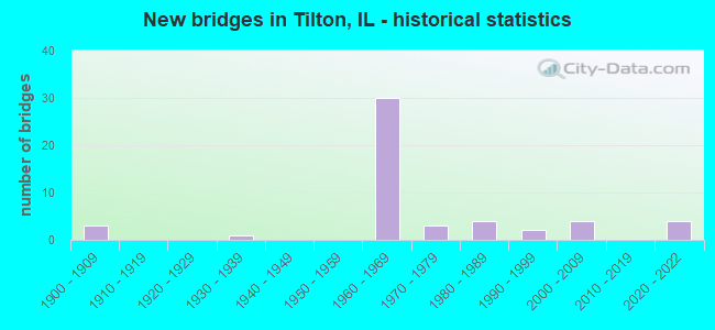
- New bridges - historical statistics
- 31900-1909
- 11930-1939
- 301960-1969
- 31970-1979
- 41980-1989
- 21990-1999
- 42000-2009
- 42020-2022

- Reconstructed bridges - Historical Statistics
- 41980-1989
- 21990-1999
- 22000-2009


- Bridge Condition - Deck
- 4.8%Excellent
- 4.8%Very good
- 14.3%Good
- 14.3%Satisfactory
- 47.6%Fair
- 9.5%Poor
- 4.8%Serious

- Bridge Condition - Superstructure
- 4.3%Excellent
- 17.4%Very good
- 8.7%Good
- 17.4%Satisfactory
- 26.1%Fair
- 17.4%Poor
- 8.7%Serious

- Bridge Condition - Substructure
- 4.3%Excellent
- 26.1%Very good
- 52.2%Good
- 13.0%Satisfactory
- 4.3%Poor

- Bridge Condition - Channel
- 25.0%Good
- 62.5%Satisfactory
- 12.5%Fair
Find on map >> Show street view
Structure Number: 920008, Location: IN TILTON (Lat: 40.104669, Lng: -87.655117), Route carried "on" structure: Interstate 74, Year Built: 1964, Year Reconstructed: 1991, Status: Open, Structure Length: 8.46m (27.76ft), Average Daily Traffic: 10,600 (year 2021), Truck Traffic: 38%, Average Future Daily Traffic: 9,140 (year 2032), Design Load: HS 20+Mod, Features Intersected: N&S & FAU 7026(L ST)
Minimum Vertical Clearance: 30+ m (98+ ft), Kilometerpoint: 346.257, Lanes on structure: 2, Lanes under structure: 2, Base Highway Network: Yes, Owner: State Highway Agency, Approaching Roadway Width: 11.9m (39.0ft), Material/Design: Steel continuous, Design/Construction: Stringer/Multi-beam, Number Of Spans In Main Unit: 4, Length of Maximum Span: 26.9m (88.3ft), Curb-To-Curb Width: 12.2m (40.0ft), Out-to-Out Width: 13.2m (43.3ft)
Condition: Deck: Fair, Superstructure: Fair, Substructure: Good, Operating Rating: 71.9 metric tons, Method Used To Determine Operating Rating: Load Factor (LF) rating reported by rating factor (RF) method using MS18 loading, Inventory Rating: 43.1 metric tons, Method Used To Determine Inventory Rating: Load Factor (LF) rating reported by rating factor (RF) method using MS18 loading, Structural Evaluation: Somewhat better than minimum adequacy, Deck Geometry: Better than present minimum criteria, Underclear: Meets minimum limits, Approach Roadway Alignment: Equal to present desirable criteria, Designated Inspection Frequency: Every 24 months, Inspection Date: April 2021, Deck Structure Type: Concrete Cast-file-Place, Wearing Surface/Protective System: Deck Protection: Epoxy Coated Reinforcing
Find on map >> Show street view
Structure Number: 920009, Location: IN TILTON (Lat: 40.104672, Lng: -87.654928), Route carried "on" structure: Interstate 74, Year Built: 1964, Year Reconstructed: 1991, Status: Open, Structure Length: 9.68m (31.76ft), Average Daily Traffic: 10,600 (year 2021), Truck Traffic: 38%, Average Future Daily Traffic: 9,140 (year 2032), Design Load: HS 20+Mod, Features Intersected: N&S & FAU 7026(L ST)
Minimum Vertical Clearance: 30+ m (98+ ft), Kilometerpoint: 346.273, Lanes on structure: 2, Lanes under structure: 2, Base Highway Network: Yes, Owner: State Highway Agency, Approaching Roadway Width: 14.9m (48.9ft), Material/Design: Steel continuous, Design/Construction: Stringer/Multi-beam, Number Of Spans In Main Unit: 5, Length of Maximum Span: 22.4m (73.5ft), Curb-To-Curb Width: 14.6m (47.9ft), Out-to-Out Width: 15.6m (51.2ft)
Condition: Deck: Fair, Superstructure: Fair, Substructure: Satisfactory, Operating Rating: 80.0 metric tons, Method Used To Determine Operating Rating: Load Factor (LF) rating reported by rating factor (RF) method using MS18 loading, Inventory Rating: 48.0 metric tons, Method Used To Determine Inventory Rating: Load Factor (LF) rating reported by rating factor (RF) method using MS18 loading, Structural Evaluation: Somewhat better than minimum adequacy, Deck Geometry: Superior to present desirable criteria, Underclear: Meets minimum limits, Approach Roadway Alignment: Equal to present desirable criteria, Designated Inspection Frequency: Every 24 months, Inspection Date: April 2021, Deck Structure Type: Concrete Cast-file-Place, Wearing Surface/Protective System: Deck Protection: Epoxy Coated Reinforcing
Find on map >> Show street view
Structure Number: 92001, Location: IN TILTON (Lat: 40.104747, Lng: -87.649519), Route carried "on" structure: Interstate 74, Year Built: 1964, Year Reconstructed: 2000, Status: Open, Structure Length: 3.58m (11.75ft), Average Daily Traffic: 11,950 (year 2021), Truck Traffic: 34%, Average Future Daily Traffic: 11,862 (year 2032), Design Load: HS 20+Mod, Features Intersected: "G" ST(FAU 7026)
Minimum Vertical Clearance: 30+ m (98+ ft), Kilometerpoint: 346.708, Lanes on structure: 2, Lanes under structure: 2, Base Highway Network: Yes, Owner: State Highway Agency, Approaching Roadway Width: 11.6m (38.1ft), Material/Design: Steel continuous, Design/Construction: Stringer/Multi-beam, Number Of Spans In Main Unit: 3, Length of Maximum Span: 11.9m (39.0ft), Curb-To-Curb Width: 12.4m (40.7ft), Out-to-Out Width: 13.4m (44.0ft)
Condition: Deck: Fair, Superstructure: Satisfactory, Substructure: Good, Operating Rating: 89.1 metric tons, Method Used To Determine Operating Rating: Load Factor (LF) rating reported by rating factor (RF) method using MS18 loading, Inventory Rating: 67.7 metric tons, Method Used To Determine Inventory Rating: Load Factor (LF) rating reported by rating factor (RF) method using MS18 loading, Structural Evaluation: Equal to present minimum criteria, Deck Geometry: Better than present minimum criteria, Underclear: Meets minimum limits, Approach Roadway Alignment: Equal to present desirable criteria, Designated Inspection Frequency: Every 24 months, Inspection Date: April 2021, Deck Structure Type: Concrete Cast-file-Place, Wearing Surface/Protective System: Deck Protection: Epoxy Coated Reinforcing
Find on map >> Show street view
Structure Number: 920011, Location: IN TILTON (Lat: 40.104750, Lng: -87.649350), Route carried "on" structure: Interstate 74, Year Built: 1964, Year Reconstructed: 2000, Status: Open, Structure Length: 3.58m (11.75ft), Average Daily Traffic: 11,950 (year 2021), Truck Traffic: 34%, Average Future Daily Traffic: 11,862 (year 2032), Design Load: HS 20+Mod, Features Intersected: "G" ST(FAU 7026)
Minimum Vertical Clearance: 30+ m (98+ ft), Kilometerpoint: 346.724, Lanes on structure: 2, Lanes under structure: 2, Base Highway Network: Yes, Owner: State Highway Agency, Approaching Roadway Width: 11.6m (38.1ft), Material/Design: Steel continuous, Design/Construction: Stringer/Multi-beam, Number Of Spans In Main Unit: 3, Length of Maximum Span: 11.9m (39.0ft), Curb-To-Curb Width: 12.4m (40.7ft), Out-to-Out Width: 13.4m (44.0ft)
Condition: Deck: Fair, Superstructure: Satisfactory, Substructure: Good, Operating Rating: 89.1 metric tons, Method Used To Determine Operating Rating: Load Factor (LF) rating reported by rating factor (RF) method using MS18 loading, Inventory Rating: 67.7 metric tons, Method Used To Determine Inventory Rating: Load Factor (LF) rating reported by rating factor (RF) method using MS18 loading, Structural Evaluation: Equal to present minimum criteria, Deck Geometry: Better than present minimum criteria, Underclear: Meets minimum limits, Approach Roadway Alignment: Equal to present desirable criteria, Designated Inspection Frequency: Every 24 months, Inspection Date: April 2021, Deck Structure Type: Concrete Cast-file-Place, Wearing Surface/Protective System: Deck Protection: Epoxy Coated Reinforcing
Find on map >> Show street view
Structure Number: 920012, Location: IN TILTON (Lat: 40.104781, Lng: -87.647117), Route carried "on" structure: Interstate 74, Year Built: 1964, Year Reconstructed: 1991, Status: Open, Structure Length: 7.25m (23.79ft), Average Daily Traffic: 11,950 (year 2021), Truck Traffic: 34%, Average Future Daily Traffic: 11,862 (year 2032), Design Load: HS 20+Mod, Features Intersected: CNRL & FR1563 & 1611
Minimum Vertical Clearance: 30+ m (98+ ft), Kilometerpoint: 346.965, Lanes on structure: 2, Lanes under structure: 8, Base Highway Network: Yes, Owner: State Highway Agency, Approaching Roadway Width: 12.8m (42.0ft), Skew: 1 degrees, Material/Design: Steel continuous, Design/Construction: Stringer/Multi-beam, Number Of Spans In Main Unit: 4, Length of Maximum Span: 20.4m (66.9ft), Curb-To-Curb Width: 12.7m (41.7ft), Out-to-Out Width: 13.6m (44.6ft)
Condition: Deck: Fair, Superstructure: Satisfactory, Substructure: Good, Operating Rating: 70.3 metric tons, Method Used To Determine Operating Rating: Load Factor (LF) rating reported by rating factor (RF) method using MS18 loading, Inventory Rating: 42.1 metric tons, Method Used To Determine Inventory Rating: Load Factor (LF) rating reported by rating factor (RF) method using MS18 loading, Structural Evaluation: Equal to present minimum criteria, Deck Geometry: Better than present minimum criteria, Underclear: Meets minimum limits, Approach Roadway Alignment: Equal to present desirable criteria, Designated Inspection Frequency: Every 24 months, Inspection Date: April 2021, Deck Structure Type: Concrete Cast-file-Place, Wearing Surface/Protective System: Deck Protection: Epoxy Coated Reinforcing
Find on map >> Show street view
Structure Number: 920013, Location: IN TILTON (Lat: 40.104781, Lng: -87.646950), Route carried "on" structure: Interstate 74, Year Built: 1964, Year Reconstructed: 1991, Status: Open, Structure Length: 7.25m (23.79ft), Average Daily Traffic: 11,950 (year 2021), Truck Traffic: 34%, Average Future Daily Traffic: 11,862 (year 2032), Design Load: HS 20+Mod, Features Intersected: CNRL & FR1563 & 1611
Minimum Vertical Clearance: 30+ m (98+ ft), Kilometerpoint: 346.981, Lanes on structure: 2, Lanes under structure: 8, Base Highway Network: Yes, Owner: State Highway Agency, Approaching Roadway Width: 15.8m (51.8ft), Skew: 1 degrees, Material/Design: Steel continuous, Design/Construction: Stringer/Multi-beam, Number Of Spans In Main Unit: 4, Length of Maximum Span: 20.4m (66.9ft), Curb-To-Curb Width: 15.8m (51.8ft), Out-to-Out Width: 16.8m (55.1ft)
Condition: Deck: Fair, Superstructure: Satisfactory, Substructure: Good, Operating Rating: 72.6 metric tons, Method Used To Determine Operating Rating: Load Factor (LF) rating reported by rating factor (RF) method using MS18 loading, Inventory Rating: 43.4 metric tons, Method Used To Determine Inventory Rating: Load Factor (LF) rating reported by rating factor (RF) method using MS18 loading, Structural Evaluation: Equal to present minimum criteria, Deck Geometry: Superior to present desirable criteria, Underclear: Meets minimum limits, Approach Roadway Alignment: Equal to present desirable criteria, Designated Inspection Frequency: Every 24 months, Inspection Date: April 2021, Deck Structure Type: Concrete Cast-file-Place, Wearing Surface/Protective System: Deck Protection: Epoxy Coated Reinforcing
Find on map >> Show street view
Structure Number: 920038, Location: S OF DANVILLE (Lat: 40.105333, Lng: -87.636000), Route carried "on" structure: US 150, Year Built: 1965, Year Reconstructed: 1996, Status: Open, Structure Length: 8.86m (29.07ft), Average Daily Traffic: 21,500 (year 2021), Truck Traffic: 5%, Average Future Daily Traffic: 23,518 (year 2032), Design Load: HS 20+Mod, Features Intersected: I-74 & CD16.23/16.33
Minimum Vertical Clearance: 30+ m (98+ ft), Kilometerpoint: 355.205, Lanes on structure: 6, Lanes under structure: 12, Base Highway Network: Yes, Owner: State Highway Agency, Approaching Roadway Width: 25.5m (83.7ft), Skew: 30 degrees, Material/Design: Steel continuous, Design/Construction: Stringer/Multi-beam, Number Of Spans In Main Unit: 6, Length of Maximum Span: 17.2m (56.4ft), Curb-To-Curb Width: 26.5m (86.9ft), Out-to-Out Width: 28.2m (92.5ft)
Condition: Deck: Satisfactory, Superstructure: Poor, Substructure: Good, Operating Rating: 82.0 metric tons, Method Used To Determine Operating Rating: Load Factor (LF) rating reported by rating factor (RF) method using MS18 loading, Inventory Rating: 46.0 metric tons, Method Used To Determine Inventory Rating: Load Factor (LF) rating reported by rating factor (RF) method using MS18 loading, Structural Evaluation: Meets minimum limits, Deck Geometry: Equal to present minimum criteria, Underclear: Somewhat better than minimum adequacy, Approach Roadway Alignment: Equal to present desirable criteria, Designated Inspection Frequency: Every 12 months, Inspection Date: April 2021, Deck Structure Type: Concrete Cast-file-Place, Wearing Surface/Protective System: Deck Protection: Epoxy Coated Reinforcing
Find on map >> Show street view
Structure Number: 920039, Location: AT S EDGE DANVILLE (Lat: 40.101764, Lng: -87.635850), Route carried "on" structure: US 150, Year Built: 1966, Year Reconstructed: 1996, Status: Open, Structure Length: 4.30m (14.11ft), Average Daily Traffic: 25,000 (year 2021), Truck Traffic: 7%, Average Future Daily Traffic: 24,340 (year 2032), Design Load: HS 20+Mod, Features Intersected: 14TH ST(FAU 7010)
Minimum Vertical Clearance: 30+ m (98+ ft), Kilometerpoint: 355.591, Lanes on structure: 4, Lanes under structure: 2, Base Highway Network: Yes, Owner: State Highway Agency, Approaching Roadway Width: 24.9m (81.7ft), Skew: 30 degrees, Material/Design: Steel continuous, Design/Construction: Stringer/Multi-beam, Number Of Spans In Main Unit: 4, Length of Maximum Span: 11.5m (37.7ft), Curb-To-Curb Width: 26.5m (86.9ft), Out-to-Out Width: 28.2m (92.5ft)
Condition: Deck: Good, Superstructure: Good, Substructure: Good, Operating Rating: 71.3 metric tons, Method Used To Determine Operating Rating: Load Factor (LF) rating reported by rating factor (RF) method using MS18 loading, Inventory Rating: 42.8 metric tons, Method Used To Determine Inventory Rating: Load Factor (LF) rating reported by rating factor (RF) method using MS18 loading, Structural Evaluation: Better than present minimum criteria, Deck Geometry: Superior to present desirable criteria, Underclear: Somewhat better than minimum adequacy, Approach Roadway Alignment: Equal to present desirable criteria, Designated Inspection Frequency: Every 48 months, Inspection Date: April 2021, Deck Structure Type: Concrete Cast-file-Place, Wearing Surface/Protective System: Deck Protection: Epoxy Coated Reinforcing
Find on map >> Show street view
Structure Number: 920128, Location: W OF TILTON (Lat: 40.105031, Lng: -87.672561), Route carried "on" structure: County highway , Year Built: 1962, Status: Open, Structure Length: 6.27m (20.57ft), Average Daily Traffic: 50 (year 2019), Truck Traffic: 4%, Average Future Daily Traffic: 61 (year 2032), Design Load: HS 15, Features Intersected: I-74, Facility Carried by Structure: TR 300
Minimum Vertical Clearance: 30+ m (98+ ft), Kilometerpoint: 3.025, Lanes on structure: 2, Lanes under structure: 4, Owner: State Highway Agency, Approaching Roadway Width: 5.5m (18.0ft), Skew: 1 degrees, Material/Design: Concrete continuous, Design/Construction: Tee Beam, Number Of Spans In Main Unit: 4, Length of Maximum Span: 17.4m (57.1ft), Curb-To-Curb Width: 7.3m (24.0ft), Out-to-Out Width: 9.1m (29.9ft)
Condition: Deck: Satisfactory, Superstructure: Good, Substructure: Good, Operating Rating: 42.1 metric tons, Method Used To Determine Operating Rating: Load Factor (LF) rating reported by rating factor (RF) method using MS18 loading, Inventory Rating: 25.3 metric tons, Method Used To Determine Inventory Rating: Load Factor (LF) rating reported by rating factor (RF) method using MS18 loading, Structural Evaluation: Equal to present minimum criteria, Deck Geometry: Equal to present minimum criteria, Underclear: Meets minimum limits, Approach Roadway Alignment: Equal to present desirable criteria, Designated Inspection Frequency: Every 24 months, Inspection Date: April 2021, Deck Structure Type: Concrete Cast-file-Place
Find on map >> Show street view
Structure Number: 920204, Location: IN TILTON (Lat: 40.105161, Lng: -87.639789), Route carried "on" structure: City street , Year Built: 2021, Status: Open, Structure Length: 10.49m (34.42ft), Average Daily Traffic: 1,850 (year 2019), Truck Traffic: 7%, Average Future Daily Traffic: 2,000 (year 2032), Design Load: HS 25 or greater, Features Intersected: I-74&CD16.23/16.33, Facility Carried by Structure: FAU 7009(CH 7)
Minimum Vertical Clearance: 30+ m (98+ ft), Kilometerpoint: 0.386, Lanes on structure: 2, Lanes under structure: 8, Owner: State Highway Agency, Approaching Roadway Width: 8.2m (26.9ft), Skew: 4 degrees, Material/Design: Steel, Design/Construction: Stringer/Multi-beam, Number Of Spans In Main Unit: 6, Length of Maximum Span: 23.2m (76.1ft), Curb or Sidewalk Widths: Left: 1.5m (4.9ft), Right: 0.0m, Curb-To-Curb Width: 9.1m (29.9ft), Out-to-Out Width: 11.9m (39.0ft)
Condition: Deck: Excellent, Superstructure: Excellent, Substructure: Excellent, Operating Rating: 50.2 metric tons, Method Used To Determine Operating Rating: Load and Resistance Factor Rating (LRFR) rating reported by rating factor(RF) method using HL-93 loadings, Inventory Rating: 38.6 metric tons, Method Used To Determine Inventory Rating: Load and Resistance Factor Rating (LRFR) rating reported by rating factor(RF) method using HL-93 loadings, Structural Evaluation: Superior to present desirable criteria, Deck Geometry: Somewhat better than minimum adequacy, Underclear: High priority of corrective action, Approach Roadway Alignment: Better than present minimum criteria, Designated Inspection Frequency: Every 24 months, Inspection Date: January 2022, Deck Structure Type: Concrete Cast-file-Place, Wearing Surface/Protective System: Deck Protection: Epoxy Coated Reinforcing
Find on map >> Show street view
Structure Number: 922031, Location: IN TILTON (Lat: 40.095025, Lng: -87.635431), Route carried "on" structure: US 150, Year Built: 1991, Status: Open, Structure Length: 1.25m (4.10ft), Average Daily Traffic: 19,700 (year 2021), Truck Traffic: 6%, Average Future Daily Traffic: 23,005 (year 2032), Design Load: HS 20+Mod, Features Intersected: GRAPE CREEK
Minimum Vertical Clearance: 30+ m (98+ ft), Kilometerpoint: 356.347, Lanes on structure: 5, Base Highway Network: Yes, Owner: State Highway Agency, Approaching Roadway Width: 21.9m (71.9ft), Skew: 1 degrees, Material/Design: Concrete, Design/Construction: Culvert, Number Of Spans In Main Unit: 3, Length of Maximum Span: 3.8m (12.5ft)
Condition: Channel: Fair, Culverts: Satisfactory, Operating Rating: 55.1 metric tons, Method Used To Determine Operating Rating: Load Factor (LF) rating reported by rating factor (RF) method using MS18 loading, Inventory Rating: 33.0 metric tons, Method Used To Determine Inventory Rating: Load Factor (LF) rating reported by rating factor (RF) method using MS18 loading, Structural Evaluation: Equal to present minimum criteria, Waterway Adequacy: Equal to present desirable criteria, Approach Roadway Alignment: Equal to present desirable criteria, Designated Inspection Frequency: Every 24 months, Inspection Date: April 2021
Find on map >> Show street view
Structure Number: 92318, Location: 1 MI SW TILTON (Lat: 40.087028, Lng: -87.663922), Route carried "on" structure: Other road , Year Built: 1900, Status: Closed, Structure Length: 0.98m (3.22ft), Average Daily Traffic: 75 (year 2019), Truck Traffic: 3%, Average Future Daily Traffic: 154 (year 2032), Features Intersected: GRAPE CREEK, Facility Carried by Structure: TR 313
Minimum Vertical Clearance: 30+ m (98+ ft), Kilometerpoint: 1.159, Lanes on structure: 1, Owner: Town or Township Highway Agency, Approaching Roadway Width: 6.7m (22.0ft), Material/Design: Steel, Design/Construction: Stringer/Multi-beam, Number Of Spans In Main Unit: 1, Length of Maximum Span: 9.4m (30.8ft), Curb-To-Curb Width: 4.6m (15.1ft), Out-to-Out Width: 5.5m (18.0ft)
Condition: Deck: Fair, Superstructure: Poor, Substructure: Poor, Channel: Satisfactory, Deck Geometry: Better than present minimum criteria, Waterway Adequacy: Equal to present minimum criteria, Approach Roadway Alignment: Somewhat better than minimum adequacy, Bridge Posting: Required (Relationship of Operating Rating to Maximum Legal Load: > 39.9% below), Length Of Structure Improvement: 1.65m (5.41ft), Designated Inspection Frequency: Every 24 months, Inspection Date: Febuary 2021, Bridge Improvement Cost: $51,000, Roadway Improvement Cost: $5,000, Total Project Cost: $77,000, Deck Structure Type: Concrete Cast-file-Place, Wearing Surface/Protective System: Wearing Surface: Gravel
Find on map >> Show street view
Structure Number: 923274, Location: CITY OF TILTON- SW (Lat: 40.090269, Lng: -87.649597), Route carried "on" structure: City street , Year Built: 1972, Status: Posted for load, Structure Length: 1.38m (4.53ft), Average Daily Traffic: 300 (year 2019), Truck Traffic: 2%, Average Future Daily Traffic: 308 (year 2032), Design Load: HS 15, Features Intersected: GRAPE CREEK, Facility Carried by Structure: TR 302
Minimum Vertical Clearance: 30+ m (98+ ft), Kilometerpoint: 0.756, Lanes on structure: 2, Owner: City or Municipal Highway Agency, Approaching Roadway Width: 6.7m (22.0ft), Material/Design: Prestressed concrete, Design/Construction: Box Beam or Girders - Multiple, Number Of Spans In Main Unit: 1, Length of Maximum Span: 13.0m (42.7ft), Curb-To-Curb Width: 8.1m (26.6ft), Out-to-Out Width: 8.2m (26.9ft)
Condition: Deck: Poor, Superstructure: Poor, Substructure: Good, Channel: Satisfactory, Operating Rating: 35.3 metric tons, Method Used To Determine Operating Rating: Load Factor (LF) rating reported by rating factor (RF) method using MS18 loading, Inventory Rating: 21.1 metric tons, Method Used To Determine Inventory Rating: Load Factor (LF) rating reported by rating factor (RF) method using MS18 loading, Structural Evaluation: Meets minimum limits, Deck Geometry: Somewhat better than minimum adequacy, Waterway Adequacy: Equal to present minimum criteria, Approach Roadway Alignment: Equal to present minimum criteria, Designated Inspection Frequency: Every 24 months, Inspection Date: Febuary 2022, Deck Structure Type: Concrete Precast Panels, Wearing Surface/Protective System: Wearing Surface: Gravel
Find on map >> Show street view
Structure Number: 923296, Location: CITY OF TILTON (Lat: 40.087186, Lng: -87.623111), Route carried "on" structure: Other road , Year Built: 1976, Status: Open, Structure Length: 3.47m (11.38ft), Average Daily Traffic: 2,150 (year 2019), Truck Traffic: 11%, Average Future Daily Traffic: 2,413 (year 2032), Design Load: HS 20, Features Intersected: GRAPE CREEK, Facility Carried by Structure: ROSS LN(FAU 7011)
Minimum Vertical Clearance: 30+ m (98+ ft), Kilometerpoint: 4.635, Lanes on structure: 2, Owner: City or Municipal Highway Agency, Approaching Roadway Width: 9.8m (32.2ft), Material/Design: Concrete, Design/Construction: Channel Beam, Number Of Spans In Main Unit: 3, Length of Maximum Span: 11.4m (37.4ft), Curb-To-Curb Width: 9.1m (29.9ft), Out-to-Out Width: 9.4m (30.8ft)
Condition: Deck: Poor, Superstructure: Poor, Substructure: Good, Channel: Good, Operating Rating: 43.1 metric tons, Method Used To Determine Operating Rating: Load Factor (LF) rating reported by rating factor (RF) method using MS18 loading, Inventory Rating: 25.9 metric tons, Method Used To Determine Inventory Rating: Load Factor (LF) rating reported by rating factor (RF) method using MS18 loading, Structural Evaluation: Meets minimum limits, Deck Geometry: Meets minimum limits, Waterway Adequacy: Equal to present minimum criteria, Approach Roadway Alignment: Somewhat better than minimum adequacy, Designated Inspection Frequency: Every 24 months, Other Special Inspection Frequency: Every 12 months, Inspection Date: Febuary 2022, Other Special Inspection Date: January 2022, Deck Structure Type: Concrete Precast Panels, Wearing Surface/Protective System: Wearing Surface: Other
Find on map >> Show street view
Structure Number: 923302, Location: 2 MI E BELGIUM (Lat: 40.064956, Lng: -87.596486), Route carried "on" structure: County highway , Year Built: 1977, Status: Open, Structure Length: 2.98m (9.78ft), Average Daily Traffic: 300 (year 2019), Truck Traffic: 6%, Average Future Daily Traffic: 411 (year 2032), Design Load: HS 20, Features Intersected: GRAPE CREEK, Facility Carried by Structure: FAS 504(TR 501)
Minimum Vertical Clearance: 30+ m (98+ ft), Kilometerpoint: 1.030, Lanes on structure: 2, Owner: Town or Township Highway Agency, Approaching Roadway Width: 6.7m (22.0ft), Skew: 1 degrees, Material/Design: Concrete, Design/Construction: Channel Beam, Number Of Spans In Main Unit: 3, Length of Maximum Span: 9.5m (31.2ft), Curb-To-Curb Width: 9.1m (29.9ft), Out-to-Out Width: 9.1m (29.9ft)
Condition: Deck: Serious, Superstructure: Serious, Substructure: Good, Channel: Satisfactory, Operating Rating: 50.2 metric tons, Method Used To Determine Operating Rating: Load Factor (LF) rating reported by rating factor (RF) method using MS18 loading, Inventory Rating: 29.8 metric tons, Method Used To Determine Inventory Rating: Load Factor (LF) rating reported by rating factor (RF) method using MS18 loading, Structural Evaluation: High priority of corrective action, Deck Geometry: Equal to present minimum criteria, Waterway Adequacy: Equal to present minimum criteria, Approach Roadway Alignment: Better than present minimum criteria, Designated Inspection Frequency: Every 24 months, Inspection Date: Febuary 2022, Deck Structure Type: Concrete Precast Panels, Wearing Surface/Protective System: Wearing Surface: Gravel
Find on map >> Show street view
Structure Number: 923337, Location: CITY OF TILTON (Lat: 40.093856, Lng: -87.637719), Route carried "on" structure: City street , Year Built: 1982, Status: Open, Structure Length: 2.56m (8.40ft), Average Daily Traffic: 625 (year 2019), Truck Traffic: 2%, Average Future Daily Traffic: 2,003 (year 2032), Design Load: HS 20, Features Intersected: GRAPE CREEK, Facility Carried by Structure: KING ST(MS 8190)
Minimum Vertical Clearance: 30+ m (98+ ft), Kilometerpoint: 1.094, Lanes on structure: 2, Owner: City or Municipal Highway Agency, Approaching Roadway Width: 10.4m (34.1ft), Skew: 1 degrees, Material/Design: Concrete, Design/Construction: Channel Beam, Number Of Spans In Main Unit: 3, Length of Maximum Span: 8.5m (27.9ft), Curb-To-Curb Width: 9.1m (29.9ft), Out-to-Out Width: 9.4m (30.8ft)
Condition: Deck: Fair, Superstructure: Fair, Substructure: Good, Channel: Satisfactory, Operating Rating: 53.8 metric tons, Method Used To Determine Operating Rating: Load Factor (LF) rating reported by rating factor (RF) method using MS18 loading, Inventory Rating: 32.4 metric tons, Method Used To Determine Inventory Rating: Load Factor (LF) rating reported by rating factor (RF) method using MS18 loading, Structural Evaluation: Somewhat better than minimum adequacy, Deck Geometry: Equal to present minimum criteria, Waterway Adequacy: Equal to present minimum criteria, Approach Roadway Alignment: Equal to present minimum criteria, Designated Inspection Frequency: Every 24 months, Inspection Date: Febuary 2022, Deck Structure Type: Concrete Precast Panels, Wearing Surface/Protective System: Wearing Surface: Gravel
Find on map >> Show street view
Structure Number: 926018, Location: S SIDE OF TILTON (Lat: 40.093203, Lng: -87.640319), Route carried "on" structure: City street , Year Built: 1939, Status: Posted for load, Structure Length: 1.07m (3.51ft), Average Daily Traffic: 1,000 (year 2019), Truck Traffic: 3%, Average Future Daily Traffic: 1,489 (year 2032), Features Intersected: GRAPE CR, Facility Carried by Structure: WASH. ST(MS 8160)
Minimum Vertical Clearance: 30+ m (98+ ft), Kilometerpoint: 0.933, Lanes on structure: 2, Owner: City or Municipal Highway Agency, Approaching Roadway Width: 6.1m (20.0ft), Skew: 1 degrees, Material/Design: Concrete, Design/Construction: Tee Beam, Number Of Spans In Main Unit: 1, Length of Maximum Span: 9.8m (32.2ft), Curb-To-Curb Width: 5.5m (18.0ft), Out-to-Out Width: 6.8m (22.3ft)
Condition: Deck: Fair, Superstructure: Serious, Substructure: Satisfactory, Channel: Good, Operating Rating: 29.2 metric tons, Method Used To Determine Operating Rating: Field evaluation and documented engineering judgment, Inventory Rating: 17.5 metric tons, Method Used To Determine Inventory Rating: Field evaluation and documented engineering judgment, Structural Evaluation: High priority of corrective action, Deck Geometry: High priority of replacement, Waterway Adequacy: Equal to present minimum criteria, Approach Roadway Alignment: Equal to present minimum criteria, Bridge Posting: Required (Relationship of Operating Rating to Maximum Legal Load: 0.1 - 9.9% below), Length Of Structure Improvement: 1.71m (5.61ft), Designated Inspection Frequency: Every 24 months, Inspection Date: Febuary 2021, Bridge Improvement Cost: $69,000, Roadway Improvement Cost: $7,000, Total Project Cost: $104,000, Deck Structure Type: Concrete Cast-file-Place, Wearing Surface/Protective System: Wearing Surface: Bituminous
Find on map >> Show street view
Structure Number: 926019, Location: SW SIDE OF TILTON (Lat: 40.099836, Lng: -87.647756), Route carried "on" structure: Other road , Year Built: 1980, Status: Open, Structure Length: 3.32m (10.89ft), Average Daily Traffic: 1,050 (year 2019), Truck Traffic: 12%, Average Future Daily Traffic: 2,362 (year 2032), Design Load: HS 20, Features Intersected: 8TH ST(MS 4070A), Facility Carried by Structure: "G" ST(FAU 7026)
Minimum Vertical Clearance: 30+ m (98+ ft), Kilometerpoint: 1.497, Lanes on structure: 2, Lanes under structure: 2, Owner: City or Municipal Highway Agency, Approaching Roadway Width: 13.4m (44.0ft), Material/Design: Steel, Design/Construction: Stringer/Multi-beam, Number Of Spans In Main Unit: 3, Length of Maximum Span: 13.4m (44.0ft), Curb or Sidewalk Widths: Left: 0.0m, Right: 1.5m (4.9ft), Curb-To-Curb Width: 8.5m (27.9ft), Out-to-Out Width: 10.7m (35.1ft)
Condition: Deck: Good, Superstructure: Fair, Substructure: Very good, Operating Rating: 44.4 metric tons, Method Used To Determine Operating Rating: Assigned rating based on Load Factor Design (LFD) reported by rating factor (RF) using MS18 loading, Inventory Rating: 32.4 metric tons, Method Used To Determine Inventory Rating: Assigned rating based on Load Factor Design (LFD) reported by rating factor (RF) using MS18 loading, Structural Evaluation: Somewhat better than minimum adequacy, Deck Geometry: Somewhat better than minimum adequacy, Underclear: High priority of corrective action, Approach Roadway Alignment: Somewhat better than minimum adequacy, Designated Inspection Frequency: Every 24 months, Inspection Date: Febuary 2021, Deck Structure Type: Concrete Cast-file-Place
Find on map >> Show street view
Structure Number: 92602, Location: SW SIDE OF TILTON (Lat: 40.099169, Lng: -87.647072), Route carried "on" structure: Other road , Year Built: 1980, Status: Open, Structure Length: 5.91m (19.39ft), Average Daily Traffic: 1,050 (year 2019), Truck Traffic: 12%, Average Future Daily Traffic: 2,362 (year 2032), Design Load: HS 20, Features Intersected: N&S RR, Facility Carried by Structure: "G" ST(FAU 7026)
Minimum Vertical Clearance: 30+ m (98+ ft), Kilometerpoint: 1.561, Lanes on structure: 2, Owner: City or Municipal Highway Agency, Approaching Roadway Width: 13.4m (44.0ft), Skew: 1 degrees, Material/Design: Steel, Design/Construction: Stringer/Multi-beam, Number Of Spans In Main Unit: 3, Length of Maximum Span: 24.7m (81.0ft), Curb or Sidewalk Widths: Left: 0.0m, Right: 1.5m (4.9ft), Curb-To-Curb Width: 8.5m (27.9ft), Out-to-Out Width: 10.7m (35.1ft)
Condition: Deck: Satisfactory, Superstructure: Fair, Substructure: Very good, Operating Rating: 44.4 metric tons, Method Used To Determine Operating Rating: Assigned rating based on Load Factor Design (LFD) reported by rating factor (RF) using MS18 loading, Inventory Rating: 32.4 metric tons, Method Used To Determine Inventory Rating: Assigned rating based on Load Factor Design (LFD) reported by rating factor (RF) using MS18 loading, Structural Evaluation: Somewhat better than minimum adequacy, Deck Geometry: Somewhat better than minimum adequacy, Underclear: High priority of corrective action, Approach Roadway Alignment: Somewhat better than minimum adequacy, Designated Inspection Frequency: Every 24 months, Inspection Date: Febuary 2021, Deck Structure Type: Concrete Cast-file-Place
Find on map >> Show street view
Structure Number: 926022, Location: S END OF TILTON (Lat: 40.092494, Lng: -87.642114), Route carried "on" structure: City street , Year Built: 1900, Status: Open, Structure Length: 0.91m (2.99ft), Average Daily Traffic: 100 (year 2019), Truck Traffic: 2%, Average Future Daily Traffic: 26 (year 2032), Features Intersected: GRAPE CREEK, Facility Carried by Structure: KEEGAN ST(MS 4160)
Minimum Vertical Clearance: 30+ m (98+ ft), Kilometerpoint: 0.225, Lanes on structure: 2, Owner: City or Municipal Highway Agency, Approaching Roadway Width: 7.3m (24.0ft), Material/Design: Concrete, Design/Construction: Slab, Number Of Spans In Main Unit: 1, Length of Maximum Span: 8.8m (28.9ft), Curb-To-Curb Width: 5.7m (18.7ft), Out-to-Out Width: 6.3m (20.7ft)
Condition: Deck: Fair, Superstructure: Fair, Substructure: Satisfactory, Channel: Satisfactory, Operating Rating: 40.5 metric tons, Method Used To Determine Operating Rating: Field evaluation and documented engineering judgment, Inventory Rating: 24.3 metric tons, Method Used To Determine Inventory Rating: Field evaluation and documented engineering judgment, Structural Evaluation: Somewhat better than minimum adequacy, Deck Geometry: Meets minimum limits, Waterway Adequacy: High priority of replacement, Approach Roadway Alignment: Equal to present minimum criteria, Length Of Structure Improvement: 1.55m (5.09ft), Designated Inspection Frequency: Every 24 months, Inspection Date: Febuary 2021, Bridge Improvement Cost: $55,000, Roadway Improvement Cost: $6,000, Total Project Cost: $83,000, Deck Structure Type: Concrete Cast-file-Place, Wearing Surface/Protective System: Wearing Surface: Gravel
Find on map >> Show street view
Structure Number: 926024, Location: TILTON-EMERSON ST. (Lat: 40.094311, Lng: -87.645022), Route carried "on" structure: Other road , Year Built: 1997, Status: Open, Structure Length: 4.24m (13.91ft), Average Daily Traffic: 900 (year 2019), Truck Traffic: 5%, Average Future Daily Traffic: 2,722 (year 2032), Design Load: HS 20, Features Intersected: CNRL RR, Facility Carried by Structure: FAU 7026(EMERSON S
Minimum Vertical Clearance: 30+ m (98+ ft), Kilometerpoint: 2.350, Lanes on structure: 2, Owner: City or Municipal Highway Agency, Approaching Roadway Width: 7.3m (24.0ft), Material/Design: Wood or Timber, Design/Construction: Slab, Number Of Spans In Main Unit: 1, Number Of Approach Spans: 2, Length of Maximum Span: 15.7m (51.5ft), Curb-To-Curb Width: 9.1m (29.9ft), Out-to-Out Width: 9.8m (32.2ft)
Condition: Deck: Good, Superstructure: Very good, Substructure: Very good, Operating Rating: 44.1 metric tons, Method Used To Determine Operating Rating: Assigned rating based on Load Factor Design (LFD) reported by rating factor (RF) using MS18 loading, Inventory Rating: 32.4 metric tons, Method Used To Determine Inventory Rating: Assigned rating based on Load Factor Design (LFD) reported by rating factor (RF) using MS18 loading, Structural Evaluation: Equal to present desirable criteria, Deck Geometry: Equal to present minimum criteria, Underclear: Equal to present minimum criteria, Approach Roadway Alignment: Equal to present minimum criteria, Designated Inspection Frequency: Every 48 months, Inspection Date: Febuary 2019, Deck Structure Type: Wood or Timber, Wearing Surface/Protective System: Wearing Surface: Bituminous
Find on map >> Show street view
Structure Number: 926035, Location: 14TH ST/N&S RR (Lat: 40.101714, Lng: -87.642956), Route carried "on" structure: Other road , Year Built: 2009, Status: Open, Structure Length: 2.97m (9.74ft), Average Daily Traffic: 2,400 (year 2019), Truck Traffic: 9%, Average Future Daily Traffic: 1,232 (year 2032), Design Load: HS 20, Features Intersected: N&S RR, Facility Carried by Structure: FAU 7010(14TH ST)
Minimum Vertical Clearance: 30+ m (98+ ft), Kilometerpoint: 0.145, Lanes on structure: 2, Owner: City or Municipal Highway Agency, Approaching Roadway Width: 9.1m (29.9ft), Skew: 5 degrees, Material/Design: Steel, Design/Construction: Stringer/Multi-beam, Number Of Spans In Main Unit: 1, Length of Maximum Span: 26.7m (87.6ft), Curb or Sidewalk Widths: Left: 3.0m (9.8ft), Right: 0.0m, Curb-To-Curb Width: 9.1m (29.9ft), Out-to-Out Width: 13.4m (44.0ft)
Condition: Deck: Very good, Superstructure: Very good, Substructure: Very good, Operating Rating: 44.1 metric tons, Method Used To Determine Operating Rating: Assigned rating based on Load Factor Design (LFD) reported by rating factor (RF) using MS18 loading, Inventory Rating: 32.4 metric tons, Method Used To Determine Inventory Rating: Assigned rating based on Load Factor Design (LFD) reported by rating factor (RF) using MS18 loading, Structural Evaluation: Equal to present desirable criteria, Deck Geometry: Meets minimum limits, Underclear: Equal to present desirable criteria, Approach Roadway Alignment: Equal to present minimum criteria, Designated Inspection Frequency: Every 48 months, Inspection Date: Febuary 2021, Deck Structure Type: Concrete Cast-file-Place, Wearing Surface/Protective System: Deck Protection: Epoxy Coated Reinforcing
Find on map >> Show street view
Structure Number: 926036, Location: 14TH OVER MAYFIELD (Lat: 40.101711, Lng: -87.644358), Route carried "on" structure: Other road , Year Built: 2007, Status: Open, Structure Length: 1.09m (3.58ft), Average Daily Traffic: 2,400 (year 2019), Truck Traffic: 9%, Average Future Daily Traffic: 1,232 (year 2032), Design Load: HS 20, Features Intersected: MS# 8122 (NO NAME), Facility Carried by Structure: FAU 7010(14TH ST)
Minimum Vertical Clearance: 30+ m (98+ ft), Kilometerpoint: 0.032, Lanes on structure: 2, Lanes under structure: 2, Owner: City or Municipal Highway Agency, Approaching Roadway Width: 7.3m (24.0ft), Skew: 1 degrees, Material/Design: Concrete, Design/Construction: Frame, Number Of Spans In Main Unit: 1, Length of Maximum Span: 10.4m (34.1ft)
Condition: Superstructure: Very good, Substructure: Very good, Operating Rating: 44.1 metric tons, Method Used To Determine Operating Rating: Assigned rating based on Load Factor Design (LFD) reported by rating factor (RF) using MS18 loading, Inventory Rating: 32.4 metric tons, Method Used To Determine Inventory Rating: Assigned rating based on Load Factor Design (LFD) reported by rating factor (RF) using MS18 loading, Structural Evaluation: Equal to present desirable criteria, Underclear: Meets minimum limits, Approach Roadway Alignment: Equal to present minimum criteria, Designated Inspection Frequency: Every 48 months, Inspection Date: Febuary 2021
Find on map >> Show street view
Structure Number: 926037, Location: 14TH ST @ TILTON (Lat: 40.101700, Lng: -87.645328), Route carried "on" structure: Other road , Year Built: 2002, Status: Open, Structure Length: 1.44m (4.72ft), Average Daily Traffic: 3,450 (year 2019), Truck Traffic: 7%, Average Future Daily Traffic: 565 (year 2032), Design Load: HS 20, Features Intersected: CSX RR, Facility Carried by Structure: FAU 7009(CH 7) 5TH
Minimum Vertical Clearance: 30+ m (98+ ft), Kilometerpoint: 8.256, Lanes on structure: 2, Owner: City or Municipal Highway Agency, Approaching Roadway Width: 12.5m (41.0ft), Material/Design: Concrete, Design/Construction: Frame, Number Of Spans In Main Unit: 1, Length of Maximum Span: 12.8m (42.0ft), Curb or Sidewalk Widths: Left: 3.0m (9.8ft), Right: 0.0m, Curb-To-Curb Width: 12.5m (41.0ft), Out-to-Out Width: 16.7m (54.8ft)
Condition: Superstructure: Very good, Substructure: Very good, Operating Rating: 44.1 metric tons, Method Used To Determine Operating Rating: Assigned rating based on Load Factor Design (LFD) reported by rating factor (RF) using MS18 loading, Inventory Rating: 32.4 metric tons, Method Used To Determine Inventory Rating: Assigned rating based on Load Factor Design (LFD) reported by rating factor (RF) using MS18 loading, Structural Evaluation: Equal to present desirable criteria, Deck Geometry: Equal to present minimum criteria, Underclear: Superior to present desirable criteria, Approach Roadway Alignment: Equal to present desirable criteria, Designated Inspection Frequency: Every 48 months, Inspection Date: Febuary 2021
Find on map >> Show street view
Structure Number: 920008, Location: IN TILTON (Lat: 40.104669, Lng: -87.654169), Route carried "under" structure: Other road , Year Built: 1964, Structure Length: 0. m, Average Daily Traffic: 1,710 (year 2019), Truck Traffic: 15%, Features Intersected: N&S & FAU 7026(L ST), Facility Carried by Structure: I-74 (EB)
Minimum Vertical Clearance: 7.34m (24.08ft), Kilometerpoint: 0.370, Lanes on structure: 2, Lanes under structure: 2, Material/Design: Steel continuous, Design/Construction: Stringer/Multi-beam, Length of Maximum Span: 26.9m (88.3ft)
Find on map >> Show street view
Structure Number: 920009, Location: IN TILTON (Lat: 40.104269, Lng: -87.654089), Route carried "under" structure: Other road , Year Built: 1964, Structure Length: 0. m, Average Daily Traffic: 1,710 (year 2019), Truck Traffic: 15%, Features Intersected: N&S & FAU 7026(L ST), Facility Carried by Structure: I-74 (WB)
Minimum Vertical Clearance: 6.83m (22.41ft), Kilometerpoint: 0.338, Lanes on structure: 2, Lanes under structure: 2, Material/Design: Steel continuous, Design/Construction: Stringer/Multi-beam, Length of Maximum Span: 22.4m (73.5ft)
Find on map >> Show street view
Structure Number: 92001, Location: IN TILTON (Lat: 40.104747, Lng: -87.649519), Route carried "under" structure: Other road , Year Built: 1964, Structure Length: 0. m, Average Daily Traffic: 1,050 (year 2019), Truck Traffic: 10%, Features Intersected: "G" ST(FAU 7026), Facility Carried by Structure: I-74 (EB)
Minimum Vertical Clearance: 4.34m (14.24ft), Kilometerpoint: 0.837, Lanes on structure: 2, Lanes under structure: 2, Material/Design: Steel continuous, Design/Construction: Stringer/Multi-beam, Length of Maximum Span: 11.9m (39.0ft)
Find on map >> Show street view
Structure Number: 920011, Location: IN TILTON (Lat: 40.104569, Lng: -87.649525), Route carried "under" structure: Other road , Year Built: 1964, Structure Length: 0. m, Average Daily Traffic: 1,050 (year 2019), Truck Traffic: 10%, Features Intersected: "G" ST(FAU 7026), Facility Carried by Structure: I-74 (WB)
Minimum Vertical Clearance: 4.32m (14.17ft), Kilometerpoint: 0.869, Lanes on structure: 2, Lanes under structure: 2, Material/Design: Steel continuous, Design/Construction: Stringer/Multi-beam, Length of Maximum Span: 11.9m (39.0ft)
Find on map >> Show street view
Structure Number: 920012, Location: IN TILTON (Lat: 40.104800, Lng: -87.645781), Route carried "under" structure: City street , Year Built: 1964, Structure Length: 0. m, Average Daily Traffic: 150 (year 2019), Truck Traffic: 3%, Features Intersected: CNRL & FR1563 & 1611, Facility Carried by Structure: I-74 (WB)
Minimum Vertical Clearance: 5.79m (19.00ft), Kilometerpoint: 0.595, Lanes on structure: 2, Lanes under structure: 4, Material/Design: Steel continuous, Design/Construction: Stringer/Multi-beam, Length of Maximum Span: 20.4m (66.9ft)
Find on map >> Show street view
Structure Number: 920012, Location: IN TILTON (Lat: 40.104792, Lng: -87.646283), Route carried "under" structure: Other road , Year Built: 1964, Structure Length: 0. m, Average Daily Traffic: 25 (year 2019), Truck Traffic: 44%, Features Intersected: CNRL & FR1563 & 1611, Facility Carried by Structure: I-74 (WB)
Minimum Vertical Clearance: 5.79m (19.00ft), Kilometerpoint: 0.692, Lanes on structure: 2, Lanes under structure: 4, Material/Design: Steel continuous, Design/Construction: Stringer/Multi-beam, Length of Maximum Span: 20.4m (66.9ft)
Find on map >> Show street view
Structure Number: 920013, Location: IN TILTON (Lat: 40.104981, Lng: -87.645825), Route carried "under" structure: City street , Year Built: 1964, Structure Length: 0. m, Average Daily Traffic: 150 (year 2019), Truck Traffic: 3%, Features Intersected: CNRL & FR1563 & 1611, Facility Carried by Structure: I-74 (EB)
Minimum Vertical Clearance: 5.69m (18.67ft), Kilometerpoint: 0.547, Lanes on structure: 2, Lanes under structure: 4, Material/Design: Steel continuous, Design/Construction: Stringer/Multi-beam, Length of Maximum Span: 20.4m (66.9ft)
Find on map >> Show street view
Structure Number: 920013, Location: IN TILTON (Lat: 40.104836, Lng: -87.646292), Route carried "under" structure: Other road , Year Built: 1964, Structure Length: 0. m, Average Daily Traffic: 25 (year 2019), Truck Traffic: 44%, Features Intersected: CNRL & FR1563 & 1611, Facility Carried by Structure: I-74 (EB)
Minimum Vertical Clearance: 5.69m (18.67ft), Kilometerpoint: 0.724, Lanes on structure: 2, Lanes under structure: 4, Material/Design: Steel continuous, Design/Construction: Stringer/Multi-beam, Length of Maximum Span: 20.4m (66.9ft)
Find on map >> Show street view
Structure Number: 920038, Location: S OF DANVILLE (Lat: 40.104942, Lng: -87.635983), Route carried "under" structure: Interstate 74, Year Built: 1965, Structure Length: 0. m, Average Daily Traffic: 27,200 (year 2021), Truck Traffic: 30%, Features Intersected: I-74 & CD16.23/16.33, Facility Carried by Structure: IL.1/US 150(FAP 33
Minimum Vertical Clearance: 5.03m (16.50ft), Kilometerpoint: 347.882, Lanes on structure: 6, Lanes under structure: 4, Material/Design: Steel continuous, Design/Construction: Stringer/Multi-beam, Length of Maximum Span: 17.2m (56.4ft)
Find on map >> Show street view
Structure Number: 920038, Location: S OF DANVILLE (Lat: 40.104825, Lng: -87.635981), Route carried "under" structure: Other road , Year Built: 1965, Structure Length: 0. m, Average Daily Traffic: 3,700 (year 2021), Truck Traffic: 11%, Features Intersected: I-74 & CD16.23/16.33, Facility Carried by Structure: IL.1/US 150(FAP 33
Minimum Vertical Clearance: 4.98m (16.34ft), Kilometerpoint: 0.579, Lanes on structure: 6, Lanes under structure: 4, Material/Design: Steel continuous, Design/Construction: Stringer/Multi-beam, Length of Maximum Span: 17.2m (56.4ft)
Find on map >> Show street view
Structure Number: 920038, Location: S OF DANVILLE (Lat: 40.105233, Lng: -87.635744), Route carried "under" structure: Other road , Year Built: 1965, Structure Length: 0. m, Average Daily Traffic: 3,700 (year 2021), Truck Traffic: 9%, Features Intersected: I-74 & CD16.23/16.33, Facility Carried by Structure: IL.1/US 150(FAP 33
Minimum Vertical Clearance: 4.98m (16.34ft), Kilometerpoint: 0.515, Lanes on structure: 6, Lanes under structure: 4, Material/Design: Steel continuous, Design/Construction: Stringer/Multi-beam, Length of Maximum Span: 17.2m (56.4ft)
Find on map >> Show street view
Structure Number: 920039, Location: AT S EDGE DANVILLE (Lat: 40.101764, Lng: -87.635850), Route carried "under" structure: Other road , Year Built: 1966, Structure Length: 0. m, Average Daily Traffic: 1,200 (year 2019), Truck Traffic: 18%, Features Intersected: 14TH ST(FAU 7010), Facility Carried by Structure: IL 1 US 150 (FAP 3
Minimum Vertical Clearance: 4.42m (14.50ft), Kilometerpoint: 0.772, Lanes on structure: 4, Lanes under structure: 2, Material/Design: Steel continuous, Design/Construction: Stringer/Multi-beam, Length of Maximum Span: 11.5m (37.7ft)
Find on map >> Show street view
Structure Number: 920128, Location: W OF TILTON (Lat: 40.104650, Lng: -87.672550), Route carried "under" structure: Interstate 74, Year Built: 1962, Structure Length: 0. m, Average Daily Traffic: 21,200 (year 2021), Truck Traffic: 38%, Features Intersected: I-74, Facility Carried by Structure: TR 300
Minimum Vertical Clearance: 5.26m (17.26ft), Kilometerpoint: 344.776, Lanes on structure: 2, Lanes under structure: 4, Material/Design: Concrete continuous, Design/Construction: Tee Beam, Length of Maximum Span: 17.4m (57.1ft)
Find on map >> Show street view
Structure Number: 920149, Location: IN TILTON (Lat: 40.105181, Lng: -87.639261), Route carried "under" structure: Other road , Year Built: 1964, Structure Length: 0. m, Average Daily Traffic: 2,500 (year 2021), Truck Traffic: 10%, Features Intersected: I-74&CD 16.23/16.33, Facility Carried by Structure: N&W RR
Minimum Vertical Clearance: 5.03m (16.50ft), Kilometerpoint: 0.789, Lanes under structure: 4, Material/Design: Steel, Design/Construction: Girder and Floorbeam System, Length of Maximum Span: 21.3m (69.9ft)
Find on map >> Show street view
Structure Number: 920149, Location: IN TILTON (Lat: 40.104783, Lng: -87.639431), Route carried "under" structure: Other road , Year Built: 1964, Structure Length: 0. m, Average Daily Traffic: 2,300 (year 2021), Truck Traffic: 13%, Features Intersected: I-74&CD 16.23/16.33, Facility Carried by Structure: N&W RR
Minimum Vertical Clearance: 5.03m (16.50ft), Kilometerpoint: 0.274, Lanes under structure: 4, Material/Design: Steel, Design/Construction: Girder and Floorbeam System, Length of Maximum Span: 21.3m (69.9ft)
Find on map >> Show street view
Structure Number: 920149, Location: IN TILTON (Lat: 40.104900, Lng: -87.639333), Route carried "under" structure: Interstate 74, Year Built: 1964, Structure Length: 0. m, Average Daily Traffic: 23,900 (year 2021), Truck Traffic: 34%, Features Intersected: I-74&CD 16.23/16.33, Facility Carried by Structure: N&W RR
Minimum Vertical Clearance: 5.03m (16.50ft), Kilometerpoint: 347.593, Lanes under structure: 4, Material/Design: Steel, Design/Construction: Girder and Floorbeam System, Length of Maximum Span: 21.3m (69.9ft)
Find on map >> Show street view
Structure Number: 92015, Location: S OF DANVILLE (Lat: 40.104864, Lng: -87.633650), Route carried "under" structure: Other road , Year Built: 1964, Structure Length: 0. m, Average Daily Traffic: 3,700 (year 2021), Truck Traffic: 11%, Features Intersected: 74,CD16.23/.33,2RAMP, Facility Carried by Structure: PEDESTRIAN BRIDGE
Minimum Vertical Clearance: 5.03m (16.50ft), Kilometerpoint: 0.772, Lanes under structure: 4, Material/Design: Steel continuous, Length of Maximum Span: 30.5m (100.1ft)
Find on map >> Show street view
Structure Number: 92015, Location: S OF DANVILLE (Lat: 40.104997, Lng: -87.632058), Route carried "under" structure: Interstate 74, Year Built: 1964, Structure Length: 0. m, Average Daily Traffic: 27,200 (year 2021), Truck Traffic: 30%, Features Intersected: 74,CD16.23/.33,2RAMP, Facility Carried by Structure: PEDESTRIAN BRIDGE
Minimum Vertical Clearance: 5.03m (16.50ft), Kilometerpoint: 348.092, Lanes under structure: 4, Material/Design: Steel continuous, Length of Maximum Span: 30.5m (100.1ft)
Find on map >> Show street view
Structure Number: 92015, Location: S OF DANVILLE (Lat: 40.104736, Lng: -87.633642), Route carried "under" structure: Other road , Year Built: 1964, Structure Length: 0. m, Average Daily Traffic: 2,950 (year 2021), Truck Traffic: 10%, Features Intersected: 74,CD16.23/.33,2RAMP, Facility Carried by Structure: PEDESTRIAN BRIDGE
Minimum Vertical Clearance: 5.03m (16.50ft), Kilometerpoint: 0.306, Lanes under structure: 4, Material/Design: Steel continuous, Length of Maximum Span: 30.5m (100.1ft)
Find on map >> Show street view
Structure Number: 92015, Location: S OF DANVILLE (Lat: 40.105358, Lng: -87.633417), Route carried "under" structure: Other road , Year Built: 1964, Structure Length: 0. m, Average Daily Traffic: 650 (year 2021), Truck Traffic: 14%, Features Intersected: 74,CD16.23/.33,2RAMP, Facility Carried by Structure: PEDESTRIAN BRIDGE
Minimum Vertical Clearance: 5.03m (16.50ft), Kilometerpoint: 0.064, Lanes under structure: 4, Material/Design: Steel continuous, Length of Maximum Span: 30.5m (100.1ft)
Find on map >> Show street view
Structure Number: 92015, Location: S OF DANVILLE (Lat: 40.105261, Lng: -87.633547), Route carried "under" structure: Other road , Year Built: 1964, Structure Length: 0. m, Average Daily Traffic: 3,700 (year 2021), Truck Traffic: 9%, Features Intersected: 74,CD16.23/.33,2RAMP, Facility Carried by Structure: PEDESTRIAN BRIDGE
Minimum Vertical Clearance: 5.03m (16.50ft), Kilometerpoint: 0.322, Lanes under structure: 4, Material/Design: Steel continuous, Length of Maximum Span: 30.5m (100.1ft)
Find on map >> Show street view
Structure Number: 920204, Location: IN TILTON (Lat: 40.104889, Lng: -87.640081), Route carried "under" structure: Interstate 74, Year Built: 2021, Structure Length: 0. m, Average Daily Traffic: 23,900 (year 2021), Truck Traffic: 34%, Features Intersected: I-74&CD16.23/16.33, Facility Carried by Structure: FAU 7009(CH 7)
Minimum Vertical Clearance: 30+ m (98+ ft), Kilometerpoint: 347.544, Lanes on structure: 2, Lanes under structure: 6, Material/Design: Steel, Design/Construction: Stringer/Multi-beam, Length of Maximum Span: 23.2m (76.1ft)
Find on map >> Show street view
Structure Number: 920204, Location: IN TILTON (Lat: 40.105161, Lng: -87.639789), Route carried "under" structure: Other road , Year Built: 2021, Structure Length: 0. m, Average Daily Traffic: 2,500 (year 2021), Truck Traffic: 10%, Features Intersected: I-74&CD16.23/16.33, Facility Carried by Structure: FAU 7009(CH 7)
Minimum Vertical Clearance: 30+ m (98+ ft), Kilometerpoint: 0.837, Lanes on structure: 2, Lanes under structure: 1, Material/Design: Steel, Design/Construction: Stringer/Multi-beam, Length of Maximum Span: 23.2m (76.1ft)
Find on map >> Show street view
Structure Number: 920204, Location: IN TILTON (Lat: 40.104769, Lng: -87.640219), Route carried "under" structure: Other road , Year Built: 2021, Structure Length: 0. m, Average Daily Traffic: 2,300 (year 2021), Truck Traffic: 13%, Features Intersected: I-74&CD16.23/16.33, Facility Carried by Structure: FAU 7009(CH 7)
Minimum Vertical Clearance: 30+ m (98+ ft), Kilometerpoint: 0.225, Lanes on structure: 2, Lanes under structure: 1, Material/Design: Steel, Design/Construction: Stringer/Multi-beam, Length of Maximum Span: 23.2m (76.1ft)
Find on map >> Show street view
Structure Number: 926019, Location: SW SIDE OF TILTON (Lat: 40.099669, Lng: -87.647519), Route carried "under" structure: City street , Year Built: 1980, Structure Length: 0. m, Average Daily Traffic: 50 (year 2019), Truck Traffic: 4%, Features Intersected: 8TH ST(MS 4070A), Facility Carried by Structure: "G" ST(FAU 7026)
Minimum Vertical Clearance: 4.88m (16.01ft), Kilometerpoint: 0.113, Lanes on structure: 2, Lanes under structure: 2, Material/Design: Steel, Design/Construction: Stringer/Multi-beam, Length of Maximum Span: 13.4m (44.0ft)
Find on map >> Show street view
Structure Number: 926036, Location: 14TH OVER MAYFIELD (Lat: 40.101739, Lng: -87.644353), Route carried "under" structure: City street , Year Built: 2007, Structure Length: 0. m, Average Daily Traffic: 25 (year 2019), Truck Traffic: 8%, Features Intersected: MS# 8122 (NO NAME), Facility Carried by Structure: FAU 7010(14TH ST)
Minimum Vertical Clearance: 4.95m (16.24ft), Kilometerpoint: 0.113, Lanes on structure: 2, Lanes under structure: 2, Material/Design: Concrete, Design/Construction: Frame, Length of Maximum Span: 10.4m (34.1ft)
Find on map >> Show street view
Structure Number: 929915, Location: .5 MI N WESTVILLE (Lat: 40.076014, Lng: -87.644628), Route carried "under" structure: Other road , Year Built: 1905, Structure Length: 0. m, Average Daily Traffic: 1,400 (year 2019), Truck Traffic: 9%, Features Intersected: FAU 7012(SPELTER AV), Facility Carried by Structure: CNRL RR
Minimum Vertical Clearance: 3.63m (11.91ft), Kilometerpoint: 0.113, Lanes under structure: 2, Material/Design: Concrete, Design/Construction: Slab, Length of Maximum Span: 6.7m (22.0ft)