Bridge Statistics for Three Oaks, Michigan (MI)
Condition, Traffic, Stress, Structural Evaluation, Project Costs
- National Bridge Inventory (NBI) Statistics
- 26Number of bridges
- 246ft / 75.3mTotal length
- $133,000Total costs
- 32,508Total average daily traffic
- 2,861Total average daily truck traffic
- 44,770Total future (year 2008) average daily traffic
- National Bridge Inventory (NBI) Registered Bridges for Three Oaks
- No street view available for this location
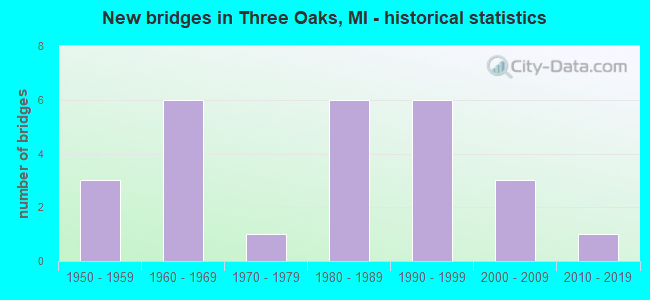
- New bridges - historical statistics
- 31950-1959
- 61960-1969
- 11970-1979
- 61980-1989
- 61990-1999
- 32000-2009
- 12010-2019


- Bridge Condition - Deck
- 20.0%Very good
- 40.0%Good
- 40.0%Satisfactory

- Bridge Condition - Superstructure
- 26.7%Very good
- 20.0%Good
- 40.0%Satisfactory
- 6.7%Fair
- 6.7%Serious

- Bridge Condition - Substructure
- 33.3%Very good
- 33.3%Good
- 20.0%Satisfactory
- 13.3%Fair

- Bridge Condition - Channel
- 40.0%Very good
- 30.0%Good
- 15.0%Satisfactory
- 10.0%Fair
- 5.0%Poor

- Bridge Condition - Culverts
- 18.2%Very good
- 54.5%Good
- 18.2%Satisfactory
- 9.1%Fair
Find on map >> Show street view
Structure Number: 101, Location: 0.5 MI W OF HOLLAND (Lat: 42.739033, Lng: -86.136372), Route carried "on" structure: County highway , Year Built: 1964, Status: Open, Structure Length: 9.14m (29.99ft), Average Daily Traffic: 1,877 (year 1997), Truck Traffic: 5%, Average Future Daily Traffic: 420 (year 2008), Design Load: H 15, Features Intersected: US-31, Facility Carried by Structure: 60 TH STREET
Minimum Vertical Clearance: 30.48m (100.00ft), Kilometerpoint: 10.281, Lanes on structure: 2, Lanes under structure: 4, Owner: State Highway Agency, Approaching Roadway Width: 9.4m (30.8ft), Skew: 4 degrees, Material/Design: Steel, Design/Construction: Stringer/Multi-beam, Number Of Spans In Main Unit: 4, Length of Maximum Span: 30.5m (100.1ft), Curb-To-Curb Width: 7.9m (25.9ft), Out-to-Out Width: 10.2m (33.5ft)
Condition: Deck: Satisfactory, Superstructure: Satisfactory, Substructure: Satisfactory, Operating Rating: 60.9 metric tons, Method Used To Determine Operating Rating: Load Factor (LF) rating reported by rating factor (RF) method using MS18 loading, Inventory Rating: 36.6 metric tons, Method Used To Determine Inventory Rating: Load Factor (LF) rating reported by rating factor (RF) method using MS18 loading, Structural Evaluation: Equal to present minimum criteria, Deck Geometry: Meets minimum limits, Underclear: Meets minimum limits, Approach Roadway Alignment: Better than present minimum criteria, Designated Inspection Frequency: Every 24 months, Inspection Date: May 2021, Deck Structure Type: Concrete Cast-file-Place, Wearing Surface/Protective System: Wearing Surface: Monolithic Concrete
Find on map >> Show street view
Structure Number: 106, Location: 0.5 MI N OF VAN BUREN COL (Lat: 42.426517, Lng: -86.252275), Route carried "on" structure: Business Interstate 196, Year Built: 1963, Year Reconstructed: 2014, Status: Open, Structure Length: 6.90m (22.64ft), Average Daily Traffic: 8,400 (year 2014), Truck Traffic: 26%, Average Future Daily Traffic: 9,325 (year 2034), Design Load: HS 20+Mod, Features Intersected: I-196 & US-31
Minimum Vertical Clearance: 30.48m (100.00ft), Kilometerpoint: 2.079, Lanes on structure: 2, Lanes under structure: 4, Base Highway Network: Yes (Inventory Route: 78, Subroute: 4), Owner: State Highway Agency, Approaching Roadway Width: 11.0m (36.1ft), Material/Design: Steel, Design/Construction: Stringer/Multi-beam, Number Of Spans In Main Unit: 4, Length of Maximum Span: 24.3m (79.7ft), Curb-To-Curb Width: 10.2m (33.5ft), Out-to-Out Width: 11.2m (36.7ft)
Condition: Deck: Satisfactory, Superstructure: Fair, Substructure: Satisfactory, Operating Rating: 64.5 metric tons, Method Used To Determine Operating Rating: Load Factor (LF) rating reported by rating factor (RF) method using MS18 loading, Inventory Rating: 38.6 metric tons, Method Used To Determine Inventory Rating: Load Factor (LF) rating reported by rating factor (RF) method using MS18 loading, Structural Evaluation: Somewhat better than minimum adequacy, Deck Geometry: Meets minimum limits, Underclear: Equal to present minimum criteria, Approach Roadway Alignment: Equal to present desirable criteria, Designated Inspection Frequency: Every 24 months, Inspection Date: May 2021, Bridge Improvement Cost: $141,000, Deck Structure Type: Concrete Cast-file-Place, Wearing Surface/Protective System: Wearing Surface: Latex Concrete
Find on map >> Show street view
Structure Number: 903, Location: 5.3 MI SW OF BERRIEN SPRG (Lat: 41.920672, Lng: -86.353008), Route carried "on" structure: County highway , Year Built: 1995, Status: Open, Structure Length: 9.84m (32.28ft), Average Daily Traffic: 500 (year 1995), Truck Traffic: 2%, Average Future Daily Traffic: 500 (year 2015), Design Load: HS 20, Features Intersected: US-31, Facility Carried by Structure: LAKE CHAPIN ROAD
Minimum Vertical Clearance: 30.48m (100.00ft), Kilometerpoint: 4.815, Lanes on structure: 2, Lanes under structure: 4, Owner: State Highway Agency, Approaching Roadway Width: 9.7m (31.8ft), Skew: 2 degrees, Material/Design: Steel continuous, Design/Construction: Stringer/Multi-beam, Number Of Spans In Main Unit: 2, Length of Maximum Span: 50.3m (165.0ft), Curb-To-Curb Width: 13.5m (44.3ft), Out-to-Out Width: 14.4m (47.2ft)
Condition: Deck: Good, Superstructure: Satisfactory, Substructure: Good, Operating Rating: 62.9 metric tons, Method Used To Determine Operating Rating: Load Factor (LF) rating reported by rating factor (RF) method using MS18 loading, Inventory Rating: 37.6 metric tons, Method Used To Determine Inventory Rating: Load Factor (LF) rating reported by rating factor (RF) method using MS18 loading, Structural Evaluation: Equal to present minimum criteria, Deck Geometry: Superior to present desirable criteria, Underclear: Somewhat better than minimum adequacy, Approach Roadway Alignment: Equal to present desirable criteria, Designated Inspection Frequency: Every 24 months, Inspection Date: May 2020, Deck Structure Type: Concrete Cast-file-Place, Wearing Surface/Protective System: Wearing Surface: Monolithic Concrete, Deck Protection: Epoxy Coated Reinforcing
Find on map >> Show street view
Structure Number: 904, Location: 4.6 MI SW OF BERRIEN SPRG (Lat: 41.930178, Lng: -86.361283), Route carried "on" structure: County highway , Year Built: 1995, Status: Open, Structure Length: 10.48m (34.38ft), Average Daily Traffic: 2,911 (year 1993), Truck Traffic: 3%, Average Future Daily Traffic: 6,000 (year 2010), Design Load: HS 20, Features Intersected: US-31, Facility Carried by Structure: SNOW ROAD
Minimum Vertical Clearance: 30.48m (100.00ft), Kilometerpoint: 20.670, Lanes on structure: 2, Lanes under structure: 6, Owner: State Highway Agency, Approaching Roadway Width: 8.5m (27.9ft), Skew: 1 degrees, Material/Design: Steel continuous, Design/Construction: Stringer/Multi-beam, Number Of Spans In Main Unit: 2, Length of Maximum Span: 52.4m (171.9ft), Curb-To-Curb Width: 13.5m (44.3ft), Out-to-Out Width: 14.4m (47.2ft)
Condition: Deck: Good, Superstructure: Satisfactory, Substructure: Good, Operating Rating: 65.8 metric tons, Method Used To Determine Operating Rating: Load Factor (LF) rating reported by rating factor (RF) method using MS18 loading, Inventory Rating: 39.2 metric tons, Method Used To Determine Inventory Rating: Load Factor (LF) rating reported by rating factor (RF) method using MS18 loading, Structural Evaluation: Equal to present minimum criteria, Deck Geometry: Superior to present desirable criteria, Underclear: Better than present minimum criteria, Approach Roadway Alignment: Equal to present desirable criteria, Designated Inspection Frequency: Every 24 months, Inspection Date: May 2020, Deck Structure Type: Concrete Cast-file-Place, Wearing Surface/Protective System: Wearing Surface: Monolithic Concrete, Deck Protection: Epoxy Coated Reinforcing
Find on map >> Show street view
Structure Number: 906, Location: 1.5 MI W BERRIEN SPRINGS (Lat: 41.943311, Lng: -86.372300), Route carried "on" structure: County highway 1136, Year Built: 1990, Status: Open, Structure Length: 8.90m (29.20ft), Average Daily Traffic: 3,332 (year 1993), Truck Traffic: 3%, Average Future Daily Traffic: 3,832 (year 2013), Design Load: HS 20, Features Intersected: US-31, Facility Carried by Structure: SHAWNEE ROAD
Minimum Vertical Clearance: 30.48m (100.00ft), Kilometerpoint: 15.851, Lanes on structure: 2, Lanes under structure: 4, Owner: State Highway Agency, Approaching Roadway Width: 8.8m (28.9ft), Skew: 2 degrees, Material/Design: Steel continuous, Design/Construction: Stringer/Multi-beam, Number Of Spans In Main Unit: 2, Length of Maximum Span: 44.5m (146.0ft), Curb-To-Curb Width: 13.4m (44.0ft), Out-to-Out Width: 13.4m (44.0ft)
Condition: Deck: Satisfactory, Superstructure: Satisfactory, Substructure: Good, Operating Rating: 72.9 metric tons, Method Used To Determine Operating Rating: Load Factor (LF) rating reported by rating factor (RF) method using MS18 loading, Inventory Rating: 43.7 metric tons, Method Used To Determine Inventory Rating: Load Factor (LF) rating reported by rating factor (RF) method using MS18 loading, Structural Evaluation: Equal to present minimum criteria, Deck Geometry: Better than present minimum criteria, Underclear: Equal to present minimum criteria, Approach Roadway Alignment: Equal to present desirable criteria, Designated Inspection Frequency: Every 24 months, Inspection Date: May 2020, Deck Structure Type: Concrete Cast-file-Place, Wearing Surface/Protective System: Wearing Surface: Monolithic Concrete, Deck Protection: Epoxy Coated Reinforcing
Find on map >> Show street view
Structure Number: 956, Location: 4.5 MI SE OF NEW BUFFALO (Lat: 41.776892, Lng: -86.663881), Route carried "on" structure: County highway , Year Built: 1991, Status: Open, Structure Length: 1.61m (5.28ft), Average Daily Traffic: 479 (year 2007), Truck Traffic: 8%, Average Future Daily Traffic: 720 (year 2027), Design Load: HS 20, Features Intersected: S BR GALIEN RIVER, Facility Carried by Structure: FOREST LAWN ROAD
Minimum Vertical Clearance: 30.48m (100.00ft), Kilometerpoint: 6.776, Lanes on structure: 2, Owner: County Highway Agency, Approaching Roadway Width: 10.4m (34.1ft), Material/Design: Prestressed concrete, Design/Construction: Box Beam or Girders - Multiple, Number Of Spans In Main Unit: 1, Length of Maximum Span: 15.8m (51.8ft), Curb-To-Curb Width: 10.7m (35.1ft), Out-to-Out Width: 11.5m (37.7ft)
Condition: Deck: Good, Superstructure: Good, Substructure: Very good, Channel: Satisfactory, Operating Rating: 61.6 metric tons, Method Used To Determine Operating Rating: Load Factor (LF) rating reported by rating factor (RF) method using MS18 loading, Inventory Rating: 36.9 metric tons, Method Used To Determine Inventory Rating: Load Factor (LF) rating reported by rating factor (RF) method using MS18 loading, Structural Evaluation: Better than present minimum criteria, Deck Geometry: Equal to present minimum criteria, Waterway Adequacy: Equal to present minimum criteria, Approach Roadway Alignment: Somewhat better than minimum adequacy, Designated Inspection Frequency: Every 24 months, Inspection Date: April 2020, Deck Structure Type: Concrete Cast-file-Place, Wearing Surface/Protective System: Wearing Surface: Monolithic Concrete, Deck Protection: Epoxy Coated Reinforcing
Find on map >> Show street view
Structure Number: 957, Location: 1.0 MI S OF THREE OAKS (Lat: 41.777172, Lng: -86.611608), Route carried "on" structure: County highway , Year Built: 2002, Status: Open, Structure Length: 1.22m (4.00ft), Average Daily Traffic: 387 (year 2007), Truck Traffic: 4%, Average Future Daily Traffic: 600 (year 2027), Design Load: HS 20+Mod, Features Intersected: SPRING CREEK, Facility Carried by Structure: FOREST LAWN ROAD
Minimum Vertical Clearance: 30.48m (100.00ft), Kilometerpoint: 11.171, Lanes on structure: 2, Owner: County Highway Agency, Approaching Roadway Width: 8.5m (27.9ft), Skew: 3 degrees, Material/Design: Prestressed concrete, Design/Construction: Box Beam or Girders - Multiple, Number Of Spans In Main Unit: 1, Length of Maximum Span: 11.7m (38.4ft), Curb-To-Curb Width: 7.9m (25.9ft), Out-to-Out Width: 10.5m (34.4ft)
Condition: Deck: Very good, Superstructure: Good, Substructure: Good, Channel: Very good, Operating Rating: 88.1 metric tons, Method Used To Determine Operating Rating: Load Factor (LF) rating reported by rating factor (RF) method using MS18 loading, Inventory Rating: 52.8 metric tons, Method Used To Determine Inventory Rating: Load Factor (LF) rating reported by rating factor (RF) method using MS18 loading, Structural Evaluation: Better than present minimum criteria, Deck Geometry: Somewhat better than minimum adequacy, Waterway Adequacy: Better than present minimum criteria, Approach Roadway Alignment: Equal to present desirable criteria, Designated Inspection Frequency: Every 24 months, Inspection Date: April 2020, Deck Structure Type: Concrete Cast-file-Place, Wearing Surface/Protective System: Wearing Surface: Monolithic Concrete, Deck Protection: Epoxy Coated Reinforcing
Find on map >> Show street view
Structure Number: 982, Location: 5.0 MI SW OF THREE OAKS (Lat: 41.761328, Lng: -86.654364), Route carried "on" structure: County highway 1115, Year Built: 1991, Status: Open, Structure Length: 1.22m (4.00ft), Average Daily Traffic: 379 (year 2007), Truck Traffic: 4%, Average Future Daily Traffic: 560 (year 2027), Design Load: HS 20, Features Intersected: SPRING CREEK, Facility Carried by Structure: BASSWOOD ROAD
Minimum Vertical Clearance: 30.48m (100.00ft), Kilometerpoint: 0.224, Lanes on structure: 2, Owner: County Highway Agency, Approaching Roadway Width: 10.4m (34.1ft), Skew: 1 degrees, Material/Design: Prestressed concrete, Design/Construction: Box Beam or Girders - Multiple, Number Of Spans In Main Unit: 1, Length of Maximum Span: 11.5m (37.7ft), Curb-To-Curb Width: 10.7m (35.1ft), Out-to-Out Width: 11.5m (37.7ft)
Condition: Deck: Good, Superstructure: Very good, Substructure: Good, Channel: Good, Operating Rating: 67.4 metric tons, Method Used To Determine Operating Rating: Load Factor (LF) rating reported by rating factor (RF) method using MS18 loading, Inventory Rating: 40.5 metric tons, Method Used To Determine Inventory Rating: Load Factor (LF) rating reported by rating factor (RF) method using MS18 loading, Structural Evaluation: Better than present minimum criteria, Deck Geometry: Better than present minimum criteria, Waterway Adequacy: Equal to present minimum criteria, Approach Roadway Alignment: Somewhat better than minimum adequacy, Designated Inspection Frequency: Every 24 months, Inspection Date: April 2020, Deck Structure Type: Concrete Cast-file-Place, Wearing Surface/Protective System: Wearing Surface: Monolithic Concrete, Deck Protection: Epoxy Coated Reinforcing
Find on map >> Show street view
Structure Number: 983, Location: 0.3 MILES S OF US-12 (Lat: 41.794408, Lng: -86.649047), Route carried "on" structure: County highway 1115, Year Built: 1989, Status: Open, Structure Length: 0.67m (2.20ft), Average Daily Traffic: 917 (year 2007), Truck Traffic: 8%, Average Future Daily Traffic: 1,280 (year 2027), Design Load: HS 20, Features Intersected: DEER CREEK, Facility Carried by Structure: BASSWOOD ROAD
Minimum Vertical Clearance: 30.48m (100.00ft), Kilometerpoint: 3.517, Lanes on structure: 2, Owner: County Highway Agency, Approaching Roadway Width: 12.2m (40.0ft), Material/Design: Concrete, Design/Construction: Culvert, Number Of Spans In Main Unit: 1, Length of Maximum Span: 6.1m (20.0ft), Curb-To-Curb Width: 12.5m (41.0ft), Out-to-Out Width: 12.8m (42.0ft)
Condition: Channel: Fair, Culverts: Good, Operating Rating: 54.5 metric tons, Method Used To Determine Operating Rating: Field evaluation and documented engineering judgment, Inventory Rating: 32.7 metric tons, Method Used To Determine Inventory Rating: Field evaluation and documented engineering judgment, Structural Evaluation: Better than present minimum criteria, Deck Geometry: Superior to present desirable criteria, Waterway Adequacy: Equal to present minimum criteria, Approach Roadway Alignment: Equal to present desirable criteria, Designated Inspection Frequency: Every 24 months, Inspection Date: April 2020
Find on map >> Show street view
Structure Number: 984, Location: 1.0 MI S OF THREE OAKS (Lat: 41.777811, Lng: -86.610642), Route carried "on" structure: County highway 1121, Year Built: 1988, Status: Open, Structure Length: 1.18m (3.87ft), Average Daily Traffic: 1,160 (year 2007), Truck Traffic: 5%, Average Future Daily Traffic: 1,740 (year 2027), Design Load: HS 20, Features Intersected: CHAMBERLAIN DRAIN, Facility Carried by Structure: THREE OAKS ROAD
Minimum Vertical Clearance: 30.48m (100.00ft), Kilometerpoint: 1.629, Lanes on structure: 2, Owner: County Highway Agency, Approaching Roadway Width: 10.4m (34.1ft), Skew: 3 degrees, Material/Design: Prestressed concrete, Design/Construction: Box Beam or Girders - Multiple, Number Of Spans In Main Unit: 1, Length of Maximum Span: 11.2m (36.7ft), Curb-To-Curb Width: 10.7m (35.1ft), Out-to-Out Width: 11.6m (38.1ft)
Condition: Deck: Satisfactory, Superstructure: Good, Substructure: Very good, Channel: Good, Operating Rating: 59.0 metric tons, Method Used To Determine Operating Rating: Load Factor (LF) rating reported by rating factor (RF) method using MS18 loading, Inventory Rating: 35.3 metric tons, Method Used To Determine Inventory Rating: Load Factor (LF) rating reported by rating factor (RF) method using MS18 loading, Structural Evaluation: Better than present minimum criteria, Deck Geometry: Equal to present minimum criteria, Waterway Adequacy: Equal to present desirable criteria, Approach Roadway Alignment: Equal to present desirable criteria, Designated Inspection Frequency: Every 24 months, Inspection Date: April 2020, Deck Structure Type: Concrete Precast Panels, Wearing Surface/Protective System: Wearing Surface: Bituminous, Membrane: Other
Find on map >> Show street view
Structure Number: 1006, Location: 5 MI E OF NEW TROY (Lat: 41.878681, Lng: -86.452158), Route carried "on" structure: County highway , Year Built: 2009, Status: Open, Structure Length: 0.80m (2.62ft), Average Daily Traffic: 165 (year 2004), Truck Traffic: 5%, Average Future Daily Traffic: 200 (year 2027), Design Load: HS 20, Features Intersected: WEAVER & HARROFF DRAIN, Facility Carried by Structure: BOYLE LAKE ROAD
Minimum Vertical Clearance: 30.48m (100.00ft), Kilometerpoint: 8.614, Lanes on structure: 2, Owner: County Highway Agency, Approaching Roadway Width: 7.9m (25.9ft), Material/Design: Concrete, Design/Construction: Culvert, Number Of Spans In Main Unit: 1, Length of Maximum Span: 7.3m (24.0ft), Curb-To-Curb Width: 7.9m (25.9ft), Out-to-Out Width: 12.2m (40.0ft)
Condition: Channel: Good, Culverts: Good, Operating Rating: 54.5 metric tons, Method Used To Determine Operating Rating: Field evaluation and documented engineering judgment, Inventory Rating: 32.7 metric tons, Method Used To Determine Inventory Rating: Field evaluation and documented engineering judgment, Structural Evaluation: Better than present minimum criteria, Waterway Adequacy: Better than present minimum criteria, Approach Roadway Alignment: Equal to present desirable criteria, Designated Inspection Frequency: Every 24 months, Inspection Date: July 2020
Find on map >> Show street view
Structure Number: 1009, Location: 2 MI W OF NEW TROY (Lat: 41.873647, Lng: -86.575439), Route carried "on" structure: County highway , Year Built: 1960, Status: Open, Structure Length: 1.79m (5.87ft), Average Daily Traffic: 307 (year 2007), Truck Traffic: 4%, Average Future Daily Traffic: 490 (year 2027), Design Load: HS 20, Features Intersected: GALIEN RIVER, Facility Carried by Structure: MINNICH ROAD
Minimum Vertical Clearance: 30.48m (100.00ft), Kilometerpoint: 2.116, Lanes on structure: 2, Owner: County Highway Agency, Approaching Roadway Width: 9.8m (32.2ft), Material/Design: Steel, Design/Construction: Stringer/Multi-beam, Number Of Spans In Main Unit: 2, Length of Maximum Span: 8.8m (28.9ft), Curb-To-Curb Width: 7.3m (24.0ft), Out-to-Out Width: 7.9m (25.9ft)
Condition: Deck: Good, Superstructure: Satisfactory, Substructure: Fair, Channel: Poor, Operating Rating: 58.6 metric tons, Method Used To Determine Operating Rating: Load Factor (LF) rating reported by rating factor (RF) method using MS18 loading, Inventory Rating: 35.3 metric tons, Method Used To Determine Inventory Rating: Load Factor (LF) rating reported by rating factor (RF) method using MS18 loading, Structural Evaluation: Somewhat better than minimum adequacy, Deck Geometry: Somewhat better than minimum adequacy, Waterway Adequacy: Somewhat better than minimum adequacy, Approach Roadway Alignment: Equal to present minimum criteria, Length Of Structure Improvement: 1.80m (5.91ft), Designated Inspection Frequency: Every 24 months, Underwater Inspection Frequency: Every 60 months, Inspection Date: July 2020, Underwater Inspection Date: June 2018, Bridge Improvement Cost: $28,000, Total Project Cost: $38,000, Deck Structure Type: Concrete Cast-file-Place, Wearing Surface/Protective System: Wearing Surface: Bituminous
Find on map >> Show street view
Structure Number: 103, Location: 4 MI SW OF THREE OAKS (Lat: 41.762733, Lng: -86.646894), Route carried "on" structure: County highway , Year Built: 1994, Status: Open, Structure Length: 1.34m (4.40ft), Average Daily Traffic: 196 (year 2007), Truck Traffic: 4%, Average Future Daily Traffic: 270 (year 2027), Design Load: HS 20, Features Intersected: SPRING CREEK, Facility Carried by Structure: MARTIN ROAD
Minimum Vertical Clearance: 30.48m (100.00ft), Kilometerpoint: 0.895, Lanes on structure: 2, Owner: County Highway Agency, Approaching Roadway Width: 10.4m (34.1ft), Skew: 1 degrees, Material/Design: Prestressed concrete, Design/Construction: Box Beam or Girders - Multiple, Number Of Spans In Main Unit: 1, Length of Maximum Span: 13.1m (43.0ft), Curb-To-Curb Width: 10.1m (33.1ft), Out-to-Out Width: 10.5m (34.4ft)
Condition: Deck: Good, Superstructure: Very good, Substructure: Very good, Channel: Satisfactory, Operating Rating: 62.2 metric tons, Method Used To Determine Operating Rating: Load Factor (LF) rating reported by rating factor (RF) method using MS18 loading, Inventory Rating: 37.3 metric tons, Method Used To Determine Inventory Rating: Load Factor (LF) rating reported by rating factor (RF) method using MS18 loading, Structural Evaluation: Equal to present desirable criteria, Deck Geometry: Better than present minimum criteria, Waterway Adequacy: Equal to present desirable criteria, Approach Roadway Alignment: Equal to present desirable criteria, Designated Inspection Frequency: Every 24 months, Inspection Date: July 2020, Deck Structure Type: Other, Wearing Surface/Protective System: Wearing Surface: Bituminous, Membrane: Built-up
Find on map >> Show street view
Structure Number: 106, Location: 700 FT N OF US-12 (Lat: 41.800897, Lng: -86.607039), Route carried "on" structure: Alternate City street , Year Built: 1980, Status: Posted for load, Structure Length: 3.29m (10.79ft), Average Daily Traffic: 600 (year 2022), Average Future Daily Traffic: 793 (year 2042), Design Load: HS 20+Mod, Features Intersected: AMTRAK RAILROAD, Facility Carried by Structure: HICKORY STREET
Minimum Vertical Clearance: 30.48m (100.00ft), Kilometerpoint: 0.232, Lanes on structure: 2, Owner: City or Municipal Highway Agency, Approaching Roadway Width: 8.5m (27.9ft), Material/Design: Prestressed concrete, Design/Construction: Box Beam or Girders - Multiple, Number Of Spans In Main Unit: 3, Length of Maximum Span: 10.9m (35.8ft), Curb or Sidewalk Widths: Left: 0.0m, Right: 1.6m (5.2ft), Curb-To-Curb Width: 8.5m (27.9ft), Out-to-Out Width: 11.2m (36.7ft)
Condition: Deck: Satisfactory, Superstructure: Serious, Substructure: Fair, Operating Rating: 29.2 metric tons, Method Used To Determine Operating Rating: Load Factor (LF) rating reported by rating factor (RF) method using MS18 loading, Inventory Rating: 17.5 metric tons, Method Used To Determine Inventory Rating: Load Factor (LF) rating reported by rating factor (RF) method using MS18 loading, Structural Evaluation: High priority of corrective action, Deck Geometry: Somewhat better than minimum adequacy, Approach Roadway Alignment: Equal to present desirable criteria, Bridge Posting: Required (Relationship of Operating Rating to Maximum Legal Load: 30.0 - 39.9% below), Designated Inspection Frequency: Every 12 months, Inspection Date: November 2021, Deck Structure Type: Other, Wearing Surface/Protective System: Wearing Surface: Bituminous, Membrane: Preformed Fabric
Find on map >> Show street view
Structure Number: 5157, Location: 0.20 MI E OF HANNA AVE (Lat: 43.233925, Lng: -85.637114), Route carried "on" structure: County highway , Year Built: 1982, Status: Open, Structure Length: 0.94m (3.08ft), Average Daily Traffic: 376 (year 2005), Average Future Daily Traffic: 640 (year 2025), Design Load: HS 20+Mod, Features Intersected: DUKE CREEK, Facility Carried by Structure: 18 MILE ROAD
Minimum Vertical Clearance: 30.48m (100.00ft), Kilometerpoint: 0.298, Lanes on structure: 2, Owner: County Highway Agency, Approaching Roadway Width: 10.4m (34.1ft), Material/Design: Aluminum, Iron, Design/Construction: Culvert, Number Of Spans In Main Unit: 2, Length of Maximum Span: 4.2m (13.8ft)
Condition: Channel: Very good, Culverts: Good, Operating Rating: 48.6 metric tons, Method Used To Determine Operating Rating: Assigned rating based on Load Factor Design (LFD) reported by rating factor (RF) using MS18 loading, Inventory Rating: 32.4 metric tons, Method Used To Determine Inventory Rating: Assigned rating based on Load Factor Design (LFD) reported by rating factor (RF) using MS18 loading, Structural Evaluation: Better than present minimum criteria, Waterway Adequacy: Equal to present desirable criteria, Approach Roadway Alignment: Equal to present desirable criteria, Designated Inspection Frequency: Every 24 months, Inspection Date: October 2020
Find on map >> Show street view
Structure Number: 5158, Location: 0.40 MI E OF HANNA AVE (Lat: 43.233933, Lng: -85.633208), Route carried "on" structure: County highway , Year Built: 1982, Status: Open, Structure Length: 0.76m (2.49ft), Average Daily Traffic: 376 (year 2005), Average Future Daily Traffic: 640 (year 2025), Design Load: HS 20+Mod, Features Intersected: DUKE CREEK, Facility Carried by Structure: 18 MILE ROAD
Minimum Vertical Clearance: 30.48m (100.00ft), Kilometerpoint: 0.615, Lanes on structure: 2, Owner: County Highway Agency, Approaching Roadway Width: 10.4m (34.1ft), Material/Design: Aluminum, Iron, Design/Construction: Culvert, Number Of Spans In Main Unit: 2, Length of Maximum Span: 3.6m (11.8ft)
Condition: Channel: Very good, Culverts: Satisfactory, Operating Rating: 48.6 metric tons, Method Used To Determine Operating Rating: Assigned rating based on Load Factor Design (LFD) reported by rating factor (RF) using MS18 loading, Inventory Rating: 32.4 metric tons, Method Used To Determine Inventory Rating: Assigned rating based on Load Factor Design (LFD) reported by rating factor (RF) using MS18 loading, Structural Evaluation: Equal to present minimum criteria, Waterway Adequacy: Equal to present desirable criteria, Approach Roadway Alignment: Equal to present desirable criteria, Designated Inspection Frequency: Every 24 months, Inspection Date: October 2020
Find on map >> Show street view
Structure Number: 5159, Location: 0.50 MI E OF HANNA AVE (Lat: 43.233936, Lng: -85.629344), Route carried "on" structure: County highway , Year Built: 1982, Status: Open, Structure Length: 0.76m (2.49ft), Average Daily Traffic: 376 (year 2005), Average Future Daily Traffic: 640 (year 2025), Design Load: HS 20+Mod, Features Intersected: DUKE CREEK, Facility Carried by Structure: 18 MILE ROAD
Minimum Vertical Clearance: 30.48m (100.00ft), Kilometerpoint: 0.929, Lanes on structure: 2, Owner: County Highway Agency, Approaching Roadway Width: 5.5m (18.0ft), Material/Design: Aluminum, Iron, Design/Construction: Culvert, Number Of Spans In Main Unit: 2, Length of Maximum Span: 3.6m (11.8ft)
Condition: Channel: Very good, Culverts: Satisfactory, Operating Rating: 48.6 metric tons, Method Used To Determine Operating Rating: Assigned rating based on Load Factor Design (LFD) reported by rating factor (RF) using MS18 loading, Inventory Rating: 32.4 metric tons, Method Used To Determine Inventory Rating: Assigned rating based on Load Factor Design (LFD) reported by rating factor (RF) using MS18 loading, Structural Evaluation: Equal to present minimum criteria, Waterway Adequacy: Equal to present desirable criteria, Approach Roadway Alignment: Equal to present desirable criteria, Designated Inspection Frequency: Every 24 months, Inspection Date: October 2020
Find on map >> Show street view
Structure Number: 5162, Location: .20 MI SW OF CEDAR SPRING (Lat: 43.257417, Lng: -85.553300), Route carried "on" structure: County highway , Year Built: 1971, Status: Open, Structure Length: 0.70m (2.30ft), Average Daily Traffic: 282 (year 2005), Average Future Daily Traffic: 480 (year 2025), Design Load: HS 20+Mod, Features Intersected: DUKE CREEK, Facility Carried by Structure: EGNER STREET
Minimum Vertical Clearance: 30.48m (100.00ft), Kilometerpoint: 3.484, Lanes on structure: 2, Owner: County Highway Agency, Approaching Roadway Width: 9.8m (32.2ft), Material/Design: Concrete, Design/Construction: Culvert, Number Of Spans In Main Unit: 3, Length of Maximum Span: 1.8m (5.9ft)
Condition: Channel: Very good, Culverts: Fair, Operating Rating: 97.2 metric tons, Method Used To Determine Operating Rating: Load Factor (LF) rating reported by rating factor (RF) method using MS18 loading, Inventory Rating: 97.2 metric tons, Method Used To Determine Inventory Rating: Load Factor (LF) rating reported by rating factor (RF) method using MS18 loading, Structural Evaluation: Somewhat better than minimum adequacy, Waterway Adequacy: Equal to present desirable criteria, Approach Roadway Alignment: Equal to present minimum criteria, Designated Inspection Frequency: Every 24 months, Inspection Date: October 2020
Find on map >> Show street view
Structure Number: 5163, Location: 200 FT N OF SOLON STREET (Lat: 43.227875, Lng: -85.671869), Route carried "on" structure: County highway , Year Built: 1966, Status: Open, Structure Length: 0.85m (2.79ft), Average Daily Traffic: 362 (year 2005), Average Future Daily Traffic: 620 (year 2025), Design Load: HS 20+Mod, Features Intersected: DUKE CREEK, Facility Carried by Structure: DIVISION AVE
Minimum Vertical Clearance: 30.48m (100.00ft), Kilometerpoint: 0.913, Lanes on structure: 2, Owner: County Highway Agency, Approaching Roadway Width: 9.8m (32.2ft), Material/Design: Steel, Design/Construction: Culvert, Number Of Spans In Main Unit: 2, Length of Maximum Span: 4.2m (13.8ft)
Condition: Channel: Very good, Culverts: Good, Operating Rating: 40.2 metric tons, Method Used To Determine Operating Rating: Load Factor (LF) rating reported by rating factor (RF) method using MS18 loading, Inventory Rating: 33.0 metric tons, Method Used To Determine Inventory Rating: Load Factor (LF) rating reported by rating factor (RF) method using MS18 loading, Structural Evaluation: Better than present minimum criteria, Waterway Adequacy: Equal to present desirable criteria, Approach Roadway Alignment: Equal to present desirable criteria, Designated Inspection Frequency: Every 24 months, Inspection Date: October 2020
Find on map >> Show street view
Structure Number: 5165, Location: 0.5 MI S OF 17 MILE RD (Lat: 43.212889, Lng: -85.571108), Route carried "on" structure: County highway , Year Built: 1967, Status: Open, Structure Length: 0.73m (2.40ft), Average Daily Traffic: 2,996 (year 2005), Average Future Daily Traffic: 5,100 (year 2025), Design Load: HS 20+Mod, Features Intersected: CEDAR CREEK, Facility Carried by Structure: WHITE CREEK ROAD
Minimum Vertical Clearance: 30.48m (100.00ft), Kilometerpoint: 4.136, Lanes on structure: 2, Owner: County Highway Agency, Approaching Roadway Width: 9.8m (32.2ft), Material/Design: Steel, Design/Construction: Culvert, Number Of Spans In Main Unit: 2, Length of Maximum Span: 3.6m (11.8ft)
Condition: Channel: Very good, Culverts: Very good, Operating Rating: 40.2 metric tons, Method Used To Determine Operating Rating: Load Factor (LF) rating reported by rating factor (RF) method using MS18 loading, Inventory Rating: 33.4 metric tons, Method Used To Determine Inventory Rating: Load Factor (LF) rating reported by rating factor (RF) method using MS18 loading, Structural Evaluation: Equal to present desirable criteria, Waterway Adequacy: Equal to present desirable criteria, Approach Roadway Alignment: Equal to present desirable criteria, Designated Inspection Frequency: Every 24 months, Inspection Date: October 2020
Find on map >> Show street view
Structure Number: 5166, Location: 0.40 MI N OF 18 MILE RD (Lat: 43.240617, Lng: -85.571264), Route carried "on" structure: County highway , Year Built: 1959, Status: Open, Structure Length: 0.79m (2.59ft), Average Daily Traffic: 2,948 (year 2005), Average Future Daily Traffic: 5,000 (year 2025), Design Load: HS 20+Mod, Features Intersected: DUKE CREEK, Facility Carried by Structure: WHITE CREEK AVE
Minimum Vertical Clearance: 30.48m (100.00ft), Kilometerpoint: 7.215, Lanes on structure: 2, Owner: County Highway Agency, Approaching Roadway Width: 7.9m (25.9ft), Skew: 2 degrees, Material/Design: Steel, Design/Construction: Culvert, Number Of Spans In Main Unit: 2, Length of Maximum Span: 3.9m (12.8ft)
Condition: Channel: Good, Culverts: Good, Operating Rating: 42.8 metric tons, Method Used To Determine Operating Rating: Load Factor (LF) rating reported by rating factor (RF) method using MS18 loading, Inventory Rating: 34.3 metric tons, Method Used To Determine Inventory Rating: Load Factor (LF) rating reported by rating factor (RF) method using MS18 loading, Structural Evaluation: Better than present minimum criteria, Waterway Adequacy: Equal to present desirable criteria, Approach Roadway Alignment: Equal to present desirable criteria, Designated Inspection Frequency: Every 24 months, Inspection Date: October 2020
Find on map >> Show street view
Structure Number: 5168, Location: 0.50 MI N OF 12 MI ROAD (Lat: 43.153883, Lng: -85.750025), Route carried "on" structure: County highway , Year Built: 1959, Status: Open, Structure Length: 1.00m (3.28ft), Average Daily Traffic: 639 (year 2004), Average Future Daily Traffic: 1,100 (year 2024), Design Load: HS 20+Mod, Features Intersected: NASH CREEK, Facility Carried by Structure: PEACH RIDGE AVE
Minimum Vertical Clearance: 30.48m (100.00ft), Kilometerpoint: 4.024, Lanes on structure: 2, Owner: County Highway Agency, Approaching Roadway Width: 6.7m (22.0ft), Material/Design: Steel, Design/Construction: Culvert, Number Of Spans In Main Unit: 3, Length of Maximum Span: 2.7m (8.9ft)
Condition: Channel: Good, Culverts: Very good, Operating Rating: 41.1 metric tons, Method Used To Determine Operating Rating: Load Factor (LF) rating reported by rating factor (RF) method using MS18 loading, Inventory Rating: 34.3 metric tons, Method Used To Determine Inventory Rating: Load Factor (LF) rating reported by rating factor (RF) method using MS18 loading, Structural Evaluation: Equal to present desirable criteria, Waterway Adequacy: Equal to present desirable criteria, Approach Roadway Alignment: Better than present minimum criteria, Designated Inspection Frequency: Every 24 months, Inspection Date: October 2021
Find on map >> Show street view
Structure Number: 5468, Location: SEC 33 RICH TWP (Lat: 43.236169, Lng: -83.306361), Route carried "on" structure: ServiceCounty highway , Year Built: 2001, Status: Open, Structure Length: 1.55m (5.09ft), Average Daily Traffic: 225 (year 2019), Average Future Daily Traffic: 275 (year 2039), Design Load: HS 20, Features Intersected: SQUAW CREEK DRAIN, Facility Carried by Structure: CASTLE ROAD
Minimum Vertical Clearance: 30.48m (100.00ft), Kilometerpoint: 10.028, Lanes on structure: 2, Owner: County Highway Agency, Approaching Roadway Width: 9.1m (29.9ft), Material/Design: Prestressed concrete, Design/Construction: Box Beam or Girders - Multiple, Number Of Spans In Main Unit: 1, Length of Maximum Span: 14.3m (46.9ft), Curb-To-Curb Width: 9.8m (32.2ft), Out-to-Out Width: 10.4m (34.1ft)
Condition: Deck: Satisfactory, Superstructure: Satisfactory, Substructure: Very good, Channel: Good, Operating Rating: 83.6 metric tons, Method Used To Determine Operating Rating: Load Factor (LF) rating reported by rating factor (RF) method using MS18 loading, Inventory Rating: 49.9 metric tons, Method Used To Determine Inventory Rating: Load Factor (LF) rating reported by rating factor (RF) method using MS18 loading, Structural Evaluation: Equal to present minimum criteria, Deck Geometry: Better than present minimum criteria, Waterway Adequacy: High priority of corrective action, Approach Roadway Alignment: Equal to present desirable criteria, Designated Inspection Frequency: Every 24 months, Inspection Date: July 2021, Deck Structure Type: Concrete Cast-file-Place, Wearing Surface/Protective System: Wearing Surface: Bituminous
Find on map >> Show street view
Structure Number: 5591, Location: DEERFIELD VILLAGE LIMITS (Lat: 41.888092, Lng: -83.777536), Route carried "on" structure: County highway 4697, Year Built: 1955, Year Reconstructed: 2008, Status: Open, Structure Length: 5.49m (18.01ft), Average Daily Traffic: 1,781 (year 2012), Truck Traffic: 6%, Average Future Daily Traffic: 2,750 (year 2031), Design Load: HS 20, Features Intersected: RAISIN RIVER, Facility Carried by Structure: BUCHOLTZ HWY
Minimum Vertical Clearance: 30.48m (100.00ft), Kilometerpoint: 1.209, Lanes on structure: 2, Owner: County Highway Agency, Approaching Roadway Width: 10.4m (34.1ft), Material/Design: Prestressed concrete, Design/Construction: Stringer/Multi-beam, Number Of Spans In Main Unit: 3, Length of Maximum Span: 18.0m (59.1ft), Curb-To-Curb Width: 10.4m (34.1ft), Out-to-Out Width: 11.0m (36.1ft)
Condition: Deck: Very good, Superstructure: Very good, Substructure: Satisfactory, Channel: Fair, Operating Rating: 70.0 metric tons, Method Used To Determine Operating Rating: Load Factor (LF), Inventory Rating: 42.0 metric tons, Method Used To Determine Inventory Rating: Load Factor (LF), Structural Evaluation: Equal to present minimum criteria, Deck Geometry: Equal to present minimum criteria, Waterway Adequacy: Better than present minimum criteria, Approach Roadway Alignment: Better than present minimum criteria, Designated Inspection Frequency: Every 24 months, Inspection Date: December 2020, Deck Structure Type: Concrete Cast-file-Place, Wearing Surface/Protective System: Wearing Surface: Monolithic Concrete, Deck Protection: Epoxy Coated Reinforcing
Find on map >> Show street view
Structure Number: 6286, Location: 0.5 MI EAST OF WOLCOTT RD (Lat: 42.820200, Lng: -82.933353), Route carried "on" structure: County highway , Year Built: 1965, Status: Open, Structure Length: 1.06m (3.48ft), Average Daily Traffic: 180 (year 2009), Truck Traffic: 2%, Average Future Daily Traffic: 295 (year 2029), Design Load: H 20, Features Intersected: COON CREEK, Facility Carried by Structure: 33 MILE ROAD
Minimum Vertical Clearance: 30.48m (100.00ft), Kilometerpoint: 6.309, Lanes on structure: 2, Owner: County Highway Agency, Approaching Roadway Width: 7.0m (23.0ft), Material/Design: Steel, Design/Construction: Culvert, Number Of Spans In Main Unit: 2, Length of Maximum Span: 4.5m (14.8ft)
Condition: Channel: Satisfactory, Culverts: Good, Operating Rating: 36.9 metric tons, Method Used To Determine Operating Rating: Load Factor (LF) rating reported by rating factor (RF) method using MS18 loading, Inventory Rating: 22.0 metric tons, Method Used To Determine Inventory Rating: Load Factor (LF) rating reported by rating factor (RF) method using MS18 loading, Structural Evaluation: Equal to present minimum criteria, Waterway Adequacy: Equal to present desirable criteria, Approach Roadway Alignment: Somewhat better than minimum adequacy, Designated Inspection Frequency: Every 24 months, Inspection Date: July 2021
Find on map >> Show street view
Structure Number: 6525, Location: 7 MILES NO OF MASHEK (Lat: 46.146653, Lng: -87.462539), Route carried "on" structure: County highway 5271, Year Built: 2018, Status: Open, Structure Length: 2.32m (7.61ft), Average Daily Traffic: 357 (year 2017), Truck Traffic: 15%, Average Future Daily Traffic: 500 (year 2037), Design Load: Greater than HL93, Features Intersected: BIG WEST RIVER, Facility Carried by Structure: COUNTY RD 557
Minimum Vertical Clearance: 30.48m (100.00ft), Kilometerpoint: 11.108, Lanes on structure: 2, Owner: County Highway Agency, Approaching Roadway Width: 12.2m (40.0ft), Material/Design: Prestressed concrete, Design/Construction: Stringer/Multi-beam, Number Of Spans In Main Unit: 1, Length of Maximum Span: 22.1m (72.5ft), Curb-To-Curb Width: 12.2m (40.0ft), Out-to-Out Width: 13.2m (43.3ft)
Condition: Deck: Very good, Superstructure: Very good, Substructure: Very good, Channel: Very good, Operating Rating: 58.6 metric tons, Method Used To Determine Operating Rating: Load and Resistance Factor Rating (LRFR) rating reported by rating factor(RF) method using HL-93 loadings, Inventory Rating: 33.0 metric tons, Method Used To Determine Inventory Rating: Load and Resistance Factor Rating (LRFR) rating reported by rating factor(RF) method using HL-93 loadings, Structural Evaluation: Equal to present desirable criteria, Deck Geometry: Superior to present desirable criteria, Waterway Adequacy: Equal to present desirable criteria, Approach Roadway Alignment: Equal to present desirable criteria, Length Of Structure Improvement: 2.29m (7.51ft), Designated Inspection Frequency: Every 24 months, Inspection Date: October 2020, Bridge Improvement Cost: $81,000, Roadway Improvement Cost: $8,000, Total Project Cost: $95,000, Deck Structure Type: Concrete Cast-file-Place, Wearing Surface/Protective System: Wearing Surface: Monolithic Concrete, Deck Protection: Epoxy Coated Reinforcing