Bridge Statistics for Thonotosassa, Florida (FL)
Condition, Traffic, Stress, Structural Evaluation, Project Costs
- National Bridge Inventory (NBI) Statistics
- 31Number of bridges
- 472ft / 144mTotal length
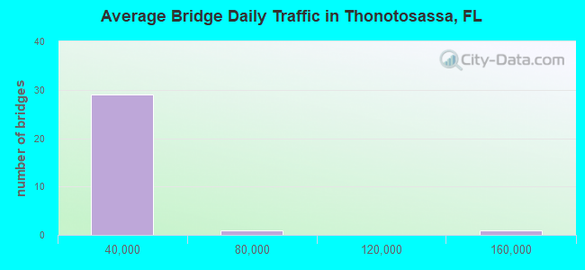
- 388,005Total average daily traffic
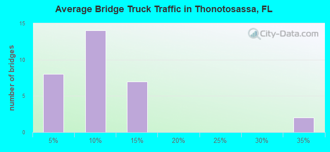
- 42,968Total average daily truck traffic
- National Bridge Inventory (NBI) Registered Bridges for Thonotosassa
- No street view available for this location
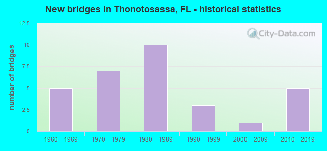
- New bridges - historical statistics
- 51960-1969
- 71970-1979
- 101980-1989
- 31990-1999
- 12000-2009
- 52010-2019
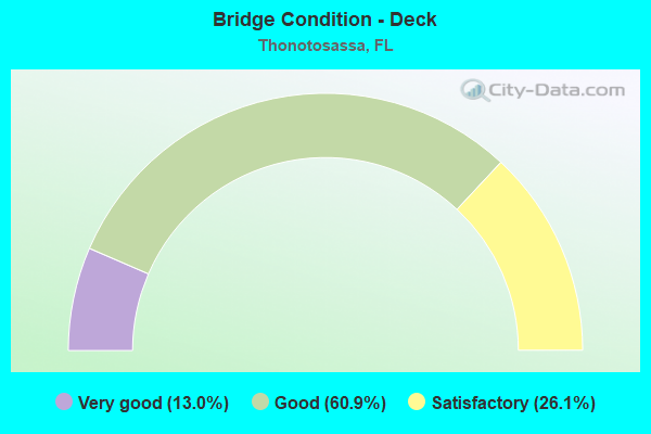
- Bridge Condition - Deck
- 13.0%Very good
- 60.9%Good
- 26.1%Satisfactory
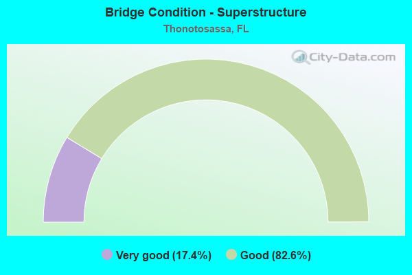
- Bridge Condition - Superstructure
- 17.4%Very good
- 82.6%Good
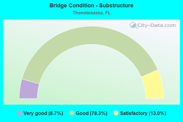
- Bridge Condition - Substructure
- 8.7%Very good
- 78.3%Good
- 13.0%Satisfactory
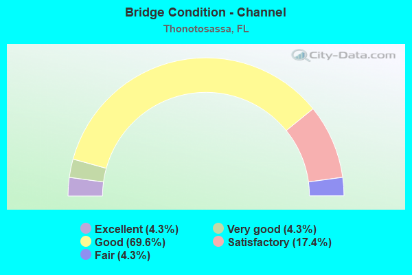
- Bridge Condition - Channel
- 4.3%Excellent
- 4.3%Very good
- 69.6%Good
- 17.4%Satisfactory
- 4.3%Fair
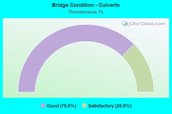
- Bridge Condition - Culverts
- 75.0%Good
- 25.0%Satisfactory
Find on map >> Show street view
Structure Number: 100026, Location: 3.7MI NE OF I-75 (Lat: 28.098611, Lng: -82.311317), Route carried "on" structure: County highway 579, Year Built: 1963, Status: Open, Structure Length: 7.62m (25.00ft), Average Daily Traffic: 3,747 (year 2022), Truck Traffic: 5%, Average Future Daily Traffic: 4,684 (year 2042), Design Load: H 20, Features Intersected: HILLSBOROUGH RIVER, Facility Carried by Structure: MORRIS BRIDGE RD.
Minimum Vertical Clearance: 30+ m (98+ ft), Kilometerpoint: 0.426, Lanes on structure: 2, Owner: County Highway Agency, Approaching Roadway Width: 9.6m (31.5ft), Skew: 3 degrees, Material/Design: Prestressed concrete, Design/Construction: Stringer/Multi-beam, Number Of Spans In Main Unit: 5, Length of Maximum Span: 15.2m (49.9ft), Curb or Sidewalk Widths: Left: 0.6m (2.0ft), Right: 0.6m (2.0ft), Curb-To-Curb Width: 8.6m (28.2ft), Out-to-Out Width: 10.4m (34.1ft)
Condition: Deck: Satisfactory, Superstructure: Good, Substructure: Good, Channel: Good, Operating Rating: 67.0 metric tons, Method Used To Determine Operating Rating: Load Factor (LF), Inventory Rating: 40.1 metric tons, Method Used To Determine Inventory Rating: Load Factor (LF), Structural Evaluation: Better than present minimum criteria, Deck Geometry: Meets minimum limits, Waterway Adequacy: Equal to present desirable criteria, Approach Roadway Alignment: Equal to present desirable criteria, Designated Inspection Frequency: Every 24 months, Underwater Inspection Frequency: Every 24 months, Inspection Date: January 2022, Underwater Inspection Date: December 2021, Deck Structure Type: Concrete Cast-file-Place
Find on map >> Show street view
Structure Number: 100052, Location: 3.0 MILES NORTH OF CR-579 (Lat: 28.091419, Lng: -82.263767), Route carried "on" structure: US 301, Year Built: 1972, Status: Open, Structure Length: 1.52m (4.99ft), Average Daily Traffic: 12,000 (year 2020), Truck Traffic: 12%, Average Future Daily Traffic: 20,820 (year 2042), Design Load: HS 20, Features Intersected: FLINT CREEK RELIEF
Minimum Vertical Clearance: 30+ m (98+ ft), Kilometerpoint: 5.998, Lanes on structure: 2, Base Highway Network: Yes, Owner: State Highway Agency, Approaching Roadway Width: 11.3m (37.1ft), Material/Design: Concrete, Design/Construction: Slab, Number Of Spans In Main Unit: 2, Length of Maximum Span: 7.7m (25.3ft), Curb-To-Curb Width: 12.3m (40.4ft), Out-to-Out Width: 12.9m (42.3ft)
Condition: Deck: Good, Superstructure: Good, Substructure: Good, Channel: Very good, Operating Rating: 75.3 metric tons, Method Used To Determine Operating Rating: Load Factor (LF), Inventory Rating: 45.4 metric tons, Method Used To Determine Inventory Rating: Load Factor (LF), Structural Evaluation: Better than present minimum criteria, Deck Geometry: Somewhat better than minimum adequacy, Waterway Adequacy: Equal to present desirable criteria, Approach Roadway Alignment: Equal to present desirable criteria, Designated Inspection Frequency: Every 24 months, Inspection Date: March 2021, Deck Structure Type: Concrete Cast-file-Place, Wearing Surface/Protective System: Wearing Surface: Bituminous
Find on map >> Show street view
Structure Number: 100053, Location: 3.6MI NORTH OF CR-579 (Lat: 28.097822, Lng: -82.255344), Route carried "on" structure: US 301, Year Built: 1972, Status: Open, Structure Length: 2.95m (9.68ft), Average Daily Traffic: 12,000 (year 2020), Truck Traffic: 12%, Average Future Daily Traffic: 20,820 (year 2042), Design Load: HS 20+Mod, Features Intersected: HOLLOMANS BRANCH
Minimum Vertical Clearance: 30+ m (98+ ft), Kilometerpoint: 7.086, Lanes on structure: 2, Base Highway Network: Yes, Owner: State Highway Agency, Approaching Roadway Width: 12.3m (40.4ft), Material/Design: Prestressed concrete, Design/Construction: Slab, Number Of Spans In Main Unit: 3, Length of Maximum Span: 9.8m (32.2ft), Curb-To-Curb Width: 12.3m (40.4ft), Out-to-Out Width: 12.8m (42.0ft)
Condition: Deck: Good, Superstructure: Good, Substructure: Good, Channel: Good, Operating Rating: 61.9 metric tons, Method Used To Determine Operating Rating: Load Factor (LF), Inventory Rating: 37.1 metric tons, Method Used To Determine Inventory Rating: Load Factor (LF), Structural Evaluation: Better than present minimum criteria, Deck Geometry: Somewhat better than minimum adequacy, Waterway Adequacy: Equal to present desirable criteria, Approach Roadway Alignment: Equal to present desirable criteria, Designated Inspection Frequency: Every 24 months, Inspection Date: March 2021, Deck Structure Type: Concrete Precast Panels, Wearing Surface/Protective System: Wearing Surface: Bituminous
Find on map >> Show street view
Structure Number: 10038, Location: 0.6MI EAST OF I-75 (Lat: 28.073444, Lng: -82.346181), Route carried "on" structure: County highway 579, Year Built: 1979, Status: Open, Structure Length: 14.20m (46.59ft), Average Daily Traffic: 4,260 (year 2022), Truck Traffic: 5%, Average Future Daily Traffic: 5,325 (year 2042), Features Intersected: TAMPA BYPASS CANAL 135, Facility Carried by Structure: MORRIS BRG. RD. SB
Minimum Vertical Clearance: 30+ m (98+ ft), Kilometerpoint: 0.000, Lanes on structure: 2, Owner: County Highway Agency, Approaching Roadway Width: 9.1m (29.9ft), Skew: 5 degrees, Material/Design: Prestressed concrete, Design/Construction: Stringer/Multi-beam, Number Of Spans In Main Unit: 10, Length of Maximum Span: 14.3m (46.9ft), Curb-To-Curb Width: 12.2m (40.0ft), Out-to-Out Width: 13.1m (43.0ft)
Condition: Deck: Satisfactory, Superstructure: Good, Substructure: Good, Channel: Good, Operating Rating: 41.7 metric tons, Method Used To Determine Operating Rating: Allowable Stress (AS), Inventory Rating: 37.5 metric tons, Method Used To Determine Inventory Rating: Allowable Stress (AS), Structural Evaluation: Better than present minimum criteria, Deck Geometry: Better than present minimum criteria, Waterway Adequacy: Equal to present minimum criteria, Approach Roadway Alignment: Equal to present desirable criteria, Designated Inspection Frequency: Every 24 months, Inspection Date: January 2022, Deck Structure Type: Concrete Cast-file-Place
Find on map >> Show street view
Structure Number: 100389, Location: 0.6MI EAST OF I-75 (Lat: 28.073253, Lng: -82.346186), Route carried "on" structure: County highway 579, Year Built: 1982, Status: Open, Structure Length: 14.36m (47.11ft), Average Daily Traffic: 4,480 (year 2022), Truck Traffic: 5%, Average Future Daily Traffic: 5,600 (year 2042), Design Load: HS 20, Features Intersected: TAMPA BYPASS CANAL 135, Facility Carried by Structure: MORRIS BRG. RD NB
Minimum Vertical Clearance: 30+ m (98+ ft), Kilometerpoint: 0.663, Lanes on structure: 2, Owner: County Highway Agency, Approaching Roadway Width: 9.1m (29.9ft), Skew: 5 degrees, Material/Design: Prestressed concrete, Design/Construction: Stringer/Multi-beam, Number Of Spans In Main Unit: 10, Length of Maximum Span: 14.3m (46.9ft), Curb-To-Curb Width: 12.1m (39.7ft), Out-to-Out Width: 12.9m (42.3ft)
Condition: Deck: Satisfactory, Superstructure: Good, Substructure: Good, Channel: Good, Operating Rating: 41.7 metric tons, Method Used To Determine Operating Rating: Allowable Stress (AS), Inventory Rating: 37.5 metric tons, Method Used To Determine Inventory Rating: Allowable Stress (AS), Structural Evaluation: Better than present minimum criteria, Deck Geometry: Better than present minimum criteria, Waterway Adequacy: Equal to present desirable criteria, Approach Roadway Alignment: Equal to present desirable criteria, Designated Inspection Frequency: Every 24 months, Inspection Date: January 2022, Deck Structure Type: Concrete Cast-file-Place
Find on map >> Show street view
Structure Number: 100398, Location: 0.2MI NORTH OF I-4 (Lat: 28.005850, Lng: -82.327308), Route carried "on" structure: Interstate 75, Year Built: 1984, Year Reconstructed: 2004, Status: Open, Structure Length: 10.78m (35.37ft), Average Daily Traffic: 128,500 (year 2021), Truck Traffic: 9%, Average Future Daily Traffic: 160,625 (year 2041), Design Load: HS 20+Mod, Features Intersected: SLIGH AVE & RAMP D-1
Minimum Vertical Clearance: 30+ m (98+ ft), Kilometerpoint: 43.991, Lanes on structure: 3, Lanes under structure: 3, Base Highway Network: Yes, Owner: State Highway Agency, Approaching Roadway Width: 22.5m (73.8ft), Skew: 9 degrees, Material/Design: Prestressed concrete, Design/Construction: Stringer/Multi-beam, Number Of Spans In Main Unit: 5, Length of Maximum Span: 32.2m (105.6ft), Curb-To-Curb Width: 22.5m (73.8ft), Out-to-Out Width: 23.1m (75.8ft)
Condition: Deck: Good, Superstructure: Very good, Substructure: Very good, Operating Rating: 79.7 metric tons, Method Used To Determine Operating Rating: Load Factor (LF), Inventory Rating: 47.8 metric tons, Method Used To Determine Inventory Rating: Load Factor (LF), Structural Evaluation: Equal to present desirable criteria, Deck Geometry: Superior to present desirable criteria, Underclear: Somewhat better than minimum adequacy, Approach Roadway Alignment: Equal to present desirable criteria, Designated Inspection Frequency: Every 24 months, Inspection Date: December 2021, Deck Structure Type: Concrete Cast-file-Place
Find on map >> Show street view
Structure Number: 100399, Location: 0.6 MILE EAST OF I-75 (Lat: 28.054297, Lng: -82.345261), Route carried "on" structure: State highway 582, Year Built: 1979, Status: Open, Structure Length: 11.07m (36.32ft), Average Daily Traffic: 8,450 (year 2021), Truck Traffic: 11%, Average Future Daily Traffic: 14,661 (year 2041), Design Load: HS 20, Features Intersected: TAMPA BYPASS CANAL
Minimum Vertical Clearance: 30+ m (98+ ft), Kilometerpoint: 11.179, Lanes on structure: 3, Base Highway Network: Yes, Owner: State Highway Agency, Approaching Roadway Width: 13.9m (45.6ft), Material/Design: Prestressed concrete, Design/Construction: Stringer/Multi-beam, Number Of Spans In Main Unit: 6, Length of Maximum Span: 18.4m (60.4ft), Curb-To-Curb Width: 17.1m (56.1ft), Out-to-Out Width: 18.1m (59.4ft)
Condition: Deck: Good, Superstructure: Good, Substructure: Good, Channel: Good, Operating Rating: 54.4 metric tons, Method Used To Determine Operating Rating: Allowable Stress (AS), Inventory Rating: 47.2 metric tons, Method Used To Determine Inventory Rating: Allowable Stress (AS), Structural Evaluation: Better than present minimum criteria, Deck Geometry: Superior to present desirable criteria, Waterway Adequacy: Equal to present desirable criteria, Approach Roadway Alignment: Equal to present desirable criteria, Designated Inspection Frequency: Every 24 months, Underwater Inspection Frequency: Every 24 months, Inspection Date: June 2021, Underwater Inspection Date: May 2021, Deck Structure Type: Concrete Precast Panels
Find on map >> Show street view
Structure Number: 100433, Location: 0.3 MI EAST OF US-301 (Lat: 28.036342, Lng: -82.344322), Route carried "on" structure: County highway , Year Built: 1980, Status: Open, Structure Length: 15.24m (50.00ft), Average Daily Traffic: 3,605 (year 2021), Truck Traffic: 2%, Average Future Daily Traffic: 4,506 (year 2041), Design Load: HS 20, Features Intersected: TAMPA BYPASS CANAL, Facility Carried by Structure: HARNEY RD.
Minimum Vertical Clearance: 30+ m (98+ ft), Kilometerpoint: 7.545, Lanes on structure: 2, Owner: County Highway Agency, Approaching Roadway Width: 9.8m (32.2ft), Material/Design: Prestressed concrete, Design/Construction: Stringer/Multi-beam, Number Of Spans In Main Unit: 10, Length of Maximum Span: 15.2m (49.9ft), Curb-To-Curb Width: 13.4m (44.0ft), Out-to-Out Width: 14.1m (46.3ft)
Condition: Deck: Good, Superstructure: Good, Substructure: Satisfactory, Channel: Good, Operating Rating: 73.0 metric tons, Method Used To Determine Operating Rating: Load Factor (LF), Inventory Rating: 43.8 metric tons, Method Used To Determine Inventory Rating: Load Factor (LF), Structural Evaluation: Equal to present minimum criteria, Deck Geometry: Better than present minimum criteria, Waterway Adequacy: Superior to present desirable criteria, Approach Roadway Alignment: Equal to present desirable criteria, Designated Inspection Frequency: Every 24 months, Underwater Inspection Frequency: Every 24 months, Inspection Date: December 2021, Underwater Inspection Date: November 2021, Deck Structure Type: Concrete Cast-file-Place
Find on map >> Show street view
Structure Number: 100472, Location: 0.6 MILE EAST OF I-75 (Lat: 28.054092, Lng: -82.345261), Route carried "on" structure: State highway 582, Year Built: 1985, Status: Open, Structure Length: 11.08m (36.35ft), Average Daily Traffic: 8,450 (year 2021), Truck Traffic: 11%, Average Future Daily Traffic: 14,661 (year 2041), Design Load: HS 20, Features Intersected: TAMPA BYPASS CANAL
Minimum Vertical Clearance: 30+ m (98+ ft), Kilometerpoint: 11.179, Lanes on structure: 3, Base Highway Network: Yes, Owner: State Highway Agency, Approaching Roadway Width: 14.2m (46.6ft), Material/Design: Prestressed concrete, Design/Construction: Stringer/Multi-beam, Number Of Spans In Main Unit: 6, Length of Maximum Span: 18.4m (60.4ft), Curb-To-Curb Width: 17.1m (56.1ft), Out-to-Out Width: 18.1m (59.4ft)
Condition: Deck: Good, Superstructure: Good, Substructure: Good, Channel: Good, Operating Rating: 55.3 metric tons, Method Used To Determine Operating Rating: Allowable Stress (AS), Inventory Rating: 49.0 metric tons, Method Used To Determine Inventory Rating: Allowable Stress (AS), Structural Evaluation: Better than present minimum criteria, Deck Geometry: Superior to present desirable criteria, Waterway Adequacy: Equal to present desirable criteria, Approach Roadway Alignment: Equal to present desirable criteria, Designated Inspection Frequency: Every 24 months, Underwater Inspection Frequency: Every 24 months, Inspection Date: June 2021, Underwater Inspection Date: May 2021, Deck Structure Type: Concrete Cast-file-Place
Find on map >> Show street view
Structure Number: 100593, Location: 3.4MI N/O JCT US301 & I-4 (Lat: 28.044975, Lng: -82.345200), Route carried "on" structure: US 301, Year Built: 2016, Status: Open, Structure Length: 15.71m (51.54ft), Average Daily Traffic: 17,900 (year 2020), Truck Traffic: 12%, Average Future Daily Traffic: 31,056 (year 2042), Design Load: HL 93, Features Intersected: TAMPA BYPASS CANAL
Minimum Vertical Clearance: 30.45m (99.90ft), Kilometerpoint: 5.650, Lanes on structure: 4, Base Highway Network: Yes, Owner: State Highway Agency, Approaching Roadway Width: 32.0m (105.0ft), Skew: 23 degrees, Material/Design: Prestressed concrete, Design/Construction: Stringer/Multi-beam, Number Of Spans In Main Unit: 5, Length of Maximum Span: 31.5m (103.3ft), Curb or Sidewalk Widths: Left: 1.5m (4.9ft), Right: 3.7m (12.1ft), Curb-To-Curb Width: 32.0m (105.0ft), Out-to-Out Width: 38.6m (126.6ft)
Condition: Deck: Very good, Superstructure: Good, Substructure: Good, Channel: Excellent, Operating Rating: 45.7 metric tons, Method Used To Determine Operating Rating: Load and Resistance Factor (LRFR), Inventory Rating: 35.3 metric tons, Method Used To Determine Inventory Rating: Load and Resistance Factor (LRFR), Structural Evaluation: Better than present minimum criteria, Deck Geometry: Superior to present desirable criteria, Waterway Adequacy: Equal to present desirable criteria, Approach Roadway Alignment: Better than present minimum criteria, Designated Inspection Frequency: Every 24 months, Underwater Inspection Frequency: Every 24 months, Inspection Date: May 2021, Underwater Inspection Date: April 2021, Deck Structure Type: Concrete Cast-file-Place
Find on map >> Show street view
Structure Number: 100615, Location: 5.0 MILES E OF I-75 (Lat: 28.022806, Lng: -82.244667), Route carried "on" structure: Interstate 4, Year Built: 1998, Status: Open, Structure Length: 7.60m (24.93ft), Average Daily Traffic: 66,250 (year 2021), Truck Traffic: 14%, Average Future Daily Traffic: 114,944 (year 2041), Design Load: HS 20+Mod, Features Intersected: MCINTOSH ROAD
Minimum Vertical Clearance: 30+ m (98+ ft), Kilometerpoint: 34.038, Lanes on structure: 3, Lanes under structure: 2, Base Highway Network: Yes, Owner: State Highway Agency, Approaching Roadway Width: 17.2m (56.4ft), Skew: 1 degrees, Material/Design: Prestressed concrete, Design/Construction: Stringer/Multi-beam, Number Of Spans In Main Unit: 4, Length of Maximum Span: 27.9m (91.5ft), Curb-To-Curb Width: 17.2m (56.4ft), Out-to-Out Width: 18.3m (60.0ft)
Condition: Deck: Good, Superstructure: Good, Substructure: Good, Operating Rating: 68.3 metric tons, Method Used To Determine Operating Rating: Load Factor (LF), Inventory Rating: 41.0 metric tons, Method Used To Determine Inventory Rating: Load Factor (LF), Structural Evaluation: Better than present minimum criteria, Deck Geometry: Better than present minimum criteria, Underclear: Superior to present desirable criteria, Approach Roadway Alignment: Equal to present desirable criteria, Designated Inspection Frequency: Every 24 months, Inspection Date: March 2021, Deck Structure Type: Concrete Cast-file-Place, Wearing Surface/Protective System: Wearing Surface: Monolithic Concrete
Find on map >> Show street view
Structure Number: 100848, Location: 0.2 MI NORTH OF I-4 (Lat: 28.005528, Lng: -82.327000), Route carried "on" structure: Ramp Interstate 75, Year Built: 2017, Status: Open, Structure Length: 2.47m (8.10ft), Average Daily Traffic: 14,500 (year 2021), Truck Traffic: 9%, Average Future Daily Traffic: 25,158 (year 2041), Design Load: HL 93, Features Intersected: RAMP D-1 TO I-75 NB
Minimum Vertical Clearance: 30.45m (99.90ft), Kilometerpoint: 0.961, Lanes on structure: 1, Lanes under structure: 1, Owner: State Highway Agency, Approaching Roadway Width: 8.2m (26.9ft), Skew: 1 degrees, Material/Design: Prestressed concrete, Design/Construction: Stringer/Multi-beam, Number Of Spans In Main Unit: 1, Length of Maximum Span: 24.7m (81.0ft), Curb-To-Curb Width: 8.2m (26.9ft), Out-to-Out Width: 9.2m (30.2ft)
Condition: Deck: Very good, Superstructure: Very good, Substructure: Good, Operating Rating: 51.0 metric tons, Method Used To Determine Operating Rating: Load and Resistance Factor (LRFR), Inventory Rating: 39.2 metric tons, Method Used To Determine Inventory Rating: Load and Resistance Factor (LRFR), Structural Evaluation: Better than present minimum criteria, Deck Geometry: Superior to present desirable criteria, Underclear: Superior to present desirable criteria, Approach Roadway Alignment: Equal to present desirable criteria, Designated Inspection Frequency: Every 24 months, Inspection Date: November 2021, Deck Structure Type: Concrete Cast-file-Place, Wearing Surface/Protective System: Wearing Surface: Monolithic Concrete
Find on map >> Show street view
Structure Number: 100849, Location: 0.3 MI NORTH OF I-4 (Lat: 28.006361, Lng: -82.327056), Route carried "on" structure: Ramp Interstate 75, Year Built: 2017, Status: Open, Structure Length: 2.17m (7.12ft), Average Daily Traffic: 14,800 (year 2021), Truck Traffic: 9%, Average Future Daily Traffic: 19,800 (year 2041), Design Load: HL 93, Features Intersected: RAMP B-1 OVER SLIGH AVE
Minimum Vertical Clearance: 30.45m (99.90ft), Kilometerpoint: 0.000, Lanes on structure: 1, Lanes under structure: 2, Base Highway Network: Yes, Owner: State Highway Agency, Approaching Roadway Width: 8.2m (26.9ft), Skew: 1 degrees, Material/Design: Prestressed concrete, Design/Construction: Stringer/Multi-beam, Number Of Spans In Main Unit: 1, Length of Maximum Span: 21.7m (71.2ft), Curb-To-Curb Width: 8.2m (26.9ft), Out-to-Out Width: 9.2m (30.2ft)
Condition: Deck: Very good, Superstructure: Very good, Substructure: Very good, Operating Rating: 49.4 metric tons, Method Used To Determine Operating Rating: Load and Resistance Factor (LRFR), Inventory Rating: 38.2 metric tons, Method Used To Determine Inventory Rating: Load and Resistance Factor (LRFR), Structural Evaluation: Equal to present desirable criteria, Deck Geometry: Superior to present desirable criteria, Underclear: Equal to present minimum criteria, Approach Roadway Alignment: Equal to present desirable criteria, Designated Inspection Frequency: Every 24 months, Inspection Date: November 2021, Deck Structure Type: Concrete Cast-file-Place, Wearing Surface/Protective System: Wearing Surface: Monolithic Concrete
Find on map >> Show street view
Structure Number: 100951, Location: 2.4 MILES NORTH OF CR-579 (Lat: 28.086278, Lng: -82.271028), Route carried "on" structure: US 301, Year Built: 1972, Status: Open, Structure Length: 2.92m (9.58ft), Average Daily Traffic: 12,000 (year 2020), Truck Traffic: 12%, Average Future Daily Traffic: 20,820 (year 2042), Design Load: HS 20, Features Intersected: FLINT CREEK
Minimum Vertical Clearance: 30+ m (98+ ft), Kilometerpoint: 5.084, Lanes on structure: 2, Base Highway Network: Yes, Owner: State Highway Agency, Approaching Roadway Width: 10.0m (32.8ft), Material/Design: Prestressed concrete, Design/Construction: Slab, Number Of Spans In Main Unit: 3, Length of Maximum Span: 9.7m (31.8ft), Curb-To-Curb Width: 12.2m (40.0ft), Out-to-Out Width: 13.1m (43.0ft)
Condition: Deck: Good, Superstructure: Good, Substructure: Good, Channel: Good, Operating Rating: 61.9 metric tons, Method Used To Determine Operating Rating: Load Factor (LF), Inventory Rating: 37.1 metric tons, Method Used To Determine Inventory Rating: Load Factor (LF), Structural Evaluation: Better than present minimum criteria, Deck Geometry: Somewhat better than minimum adequacy, Waterway Adequacy: Equal to present desirable criteria, Approach Roadway Alignment: Equal to present desirable criteria, Designated Inspection Frequency: Every 24 months, Underwater Inspection Frequency: Every 24 months, Inspection Date: March 2021, Underwater Inspection Date: Febuary 2021, Deck Structure Type: Concrete Precast Panels, Wearing Surface/Protective System: Wearing Surface: Bituminous
Find on map >> Show street view
Structure Number: 104294, Location: 0.7MI N/O CR-582 (Lat: 28.087278, Lng: -82.226389), Route carried "on" structure: County highway , Year Built: 1984, Status: Open, Structure Length: 1.13m (3.71ft), Average Daily Traffic: 500 (year 2020), Truck Traffic: 1%, Average Future Daily Traffic: 722 (year 2040), Design Load: HS 20, Features Intersected: BRAHMA CREEK, Facility Carried by Structure: FIVE ACRE ROAD
Minimum Vertical Clearance: 30+ m (98+ ft), Kilometerpoint: 0.000, Lanes on structure: 2, Owner: County Highway Agency, Approaching Roadway Width: 6.7m (22.0ft), Skew: 3 degrees, Material/Design: Concrete, Design/Construction: Culvert, Number Of Spans In Main Unit: 3, Length of Maximum Span: 3.8m (12.5ft)
Condition: Channel: Good, Culverts: Good, Operating Rating: 54.6 metric tons, Method Used To Determine Operating Rating: Load Factor (LF), Inventory Rating: 32.7 metric tons, Method Used To Determine Inventory Rating: Load Factor (LF), Structural Evaluation: Better than present minimum criteria, Waterway Adequacy: Better than present minimum criteria, Approach Roadway Alignment: Equal to present desirable criteria, Designated Inspection Frequency: Every 24 months, Inspection Date: August 2020
Find on map >> Show street view
Structure Number: 104406, Location: 0.9MI S OF US-301 (Lat: 28.093794, Lng: -82.249158), Route carried "on" structure: County highway , Year Built: 1967, Status: Open, Structure Length: 2.76m (9.06ft), Average Daily Traffic: 1,100 (year 2022), Truck Traffic: 2%, Average Future Daily Traffic: 1,375 (year 2042), Features Intersected: HOLLOMANS CREEK, Facility Carried by Structure: MCINTOSH RD.
Minimum Vertical Clearance: 30+ m (98+ ft), Kilometerpoint: 0.000, Lanes on structure: 2, Owner: County Highway Agency, Approaching Roadway Width: 8.4m (27.6ft), Material/Design: Prestressed concrete, Design/Construction: Channel Beam, Number Of Spans In Main Unit: 3, Length of Maximum Span: 9.2m (30.2ft), Curb-To-Curb Width: 8.4m (27.6ft), Out-to-Out Width: 9.0m (29.5ft)
Condition: Deck: Satisfactory, Superstructure: Good, Substructure: Good, Channel: Satisfactory, Operating Rating: 55.2 metric tons, Method Used To Determine Operating Rating: Load Factor (LF), Inventory Rating: 33.1 metric tons, Method Used To Determine Inventory Rating: Load Factor (LF), Structural Evaluation: Better than present minimum criteria, Deck Geometry: Meets minimum limits, Waterway Adequacy: Superior to present desirable criteria, Approach Roadway Alignment: Equal to present desirable criteria, Designated Inspection Frequency: Every 24 months, Inspection Date: January 2022, Deck Structure Type: Concrete Cast-file-Place
Find on map >> Show street view
Structure Number: 104407, Location: 0.8MI N OF FRANKLIN RD (Lat: 28.093250, Lng: -82.240944), Route carried "on" structure: County highway , Year Built: 1965, Status: Open, Structure Length: 1.62m (5.31ft), Average Daily Traffic: 300 (year 2022), Truck Traffic: 1%, Average Future Daily Traffic: 375 (year 2042), Design Load: H 15, Features Intersected: HOLLOMANS BRANCH, Facility Carried by Structure: IKE SMITH ROAD
Minimum Vertical Clearance: 30+ m (98+ ft), Kilometerpoint: 0.000, Lanes on structure: 2, Owner: County Highway Agency, Approaching Roadway Width: 6.2m (20.3ft), Skew: 5 degrees, Material/Design: Prestressed concrete, Design/Construction: Channel Beam, Number Of Spans In Main Unit: 2, Length of Maximum Span: 8.2m (26.9ft), Curb-To-Curb Width: 8.6m (28.2ft), Out-to-Out Width: 9.2m (30.2ft)
Condition: Deck: Satisfactory, Superstructure: Good, Substructure: Satisfactory, Channel: Satisfactory, Operating Rating: 54.1 metric tons, Method Used To Determine Operating Rating: Load Factor (LF), Inventory Rating: 32.5 metric tons, Method Used To Determine Inventory Rating: Load Factor (LF), Structural Evaluation: Equal to present minimum criteria, Deck Geometry: Equal to present minimum criteria, Waterway Adequacy: Better than present minimum criteria, Approach Roadway Alignment: Equal to present minimum criteria, Designated Inspection Frequency: Every 24 months, Inspection Date: January 2022, Deck Structure Type: Concrete Cast-file-Place
Find on map >> Show street view
Structure Number: 104409, Location: 3.8MI S OF US-301 (Lat: 28.052794, Lng: -82.249158), Route carried "on" structure: County highway , Year Built: 1965, Status: Open, Structure Length: 1.60m (5.25ft), Average Daily Traffic: 2,630 (year 2022), Truck Traffic: 3%, Average Future Daily Traffic: 3,287 (year 2042), Design Load: H 15, Features Intersected: CAMPBELL CREEK, Facility Carried by Structure: MCINTOSH ROAD
Minimum Vertical Clearance: 30+ m (98+ ft), Kilometerpoint: 0.000, Lanes on structure: 2, Owner: County Highway Agency, Approaching Roadway Width: 8.6m (28.2ft), Material/Design: Prestressed concrete, Design/Construction: Channel Beam, Number Of Spans In Main Unit: 2, Length of Maximum Span: 8.0m (26.2ft), Curb-To-Curb Width: 8.6m (28.2ft), Out-to-Out Width: 9.3m (30.5ft)
Condition: Deck: Satisfactory, Superstructure: Good, Substructure: Good, Channel: Good, Operating Rating: 64.0 metric tons, Method Used To Determine Operating Rating: Load Factor (LF), Inventory Rating: 38.4 metric tons, Method Used To Determine Inventory Rating: Load Factor (LF), Structural Evaluation: Better than present minimum criteria, Deck Geometry: Meets minimum limits, Waterway Adequacy: Equal to present minimum criteria, Approach Roadway Alignment: Equal to present desirable criteria, Designated Inspection Frequency: Every 24 months, Inspection Date: January 2022, Deck Structure Type: Concrete Cast-file-Place
Find on map >> Show street view
Structure Number: 10441, Location: 0.1MI NORTH OF GORE RD. (Lat: 28.026300, Lng: -82.236519), Route carried "on" structure: County highway , Year Built: 1965, Status: Open, Structure Length: 1.62m (5.31ft), Average Daily Traffic: 1,300 (year 2021), Truck Traffic: 5%, Average Future Daily Traffic: 2,256 (year 2042), Design Load: H 15, Features Intersected: PEMBERTON CREEK, Facility Carried by Structure: GALLAGHER ROAD
Minimum Vertical Clearance: 30+ m (98+ ft), Kilometerpoint: 0.000, Lanes on structure: 2, Owner: County Highway Agency, Approaching Roadway Width: 6.2m (20.3ft), Material/Design: Prestressed concrete, Design/Construction: Channel Beam, Number Of Spans In Main Unit: 2, Length of Maximum Span: 8.1m (26.6ft), Curb-To-Curb Width: 8.6m (28.2ft), Out-to-Out Width: 9.2m (30.2ft)
Condition: Deck: Good, Superstructure: Good, Substructure: Good, Channel: Good, Operating Rating: 59.0 metric tons, Method Used To Determine Operating Rating: Load Factor (LF), Inventory Rating: 35.4 metric tons, Method Used To Determine Inventory Rating: Load Factor (LF), Structural Evaluation: Better than present minimum criteria, Deck Geometry: Somewhat better than minimum adequacy, Waterway Adequacy: Better than present minimum criteria, Approach Roadway Alignment: Better than present minimum criteria, Designated Inspection Frequency: Every 24 months, Inspection Date: November 2021, Deck Structure Type: Concrete Cast-file-Place, Wearing Surface/Protective System: Wearing Surface: Bituminous
Find on map >> Show street view
Structure Number: 104439, Location: 1MI N OF KNIGHTS-GRIFFIN (Lat: 28.090222, Lng: -82.220342), Route carried "on" structure: County highway , Year Built: 1983, Status: Open, Structure Length: 0.70m (2.30ft), Average Daily Traffic: 50 (year 2022), Truck Traffic: 2%, Average Future Daily Traffic: 63 (year 2042), Design Load: HS 20, Features Intersected: HOLLOMANS BRANCH, Facility Carried by Structure: PLESS ROAD
Minimum Vertical Clearance: 30+ m (98+ ft), Kilometerpoint: 0.000, Lanes on structure: 2, Owner: County Highway Agency, Approaching Roadway Width: 6.6m (21.7ft), Skew: 9 degrees, Material/Design: Concrete, Design/Construction: Culvert, Number Of Spans In Main Unit: 3, Length of Maximum Span: 2.3m (7.5ft)
Condition: Channel: Satisfactory, Culverts: Satisfactory, Inventory Rating: 79.0 metric tons, Method Used To Determine Inventory Rating: Load Factor (LF), Structural Evaluation: Equal to present minimum criteria, Waterway Adequacy: Equal to present minimum criteria, Approach Roadway Alignment: Equal to present desirable criteria, Designated Inspection Frequency: Every 24 months, Underwater Inspection Frequency: Every 24 months, Inspection Date: January 2022, Underwater Inspection Date: December 2021
Find on map >> Show street view
Structure Number: 10444, Location: 0.5MI NORTH OF I-4 (Lat: 28.028269, Lng: -82.244700), Route carried "on" structure: County highway , Year Built: 1972, Status: Open, Structure Length: 1.86m (6.10ft), Average Daily Traffic: 2,500 (year 2021), Truck Traffic: 5%, Average Future Daily Traffic: 3,125 (year 2041), Design Load: H 20, Features Intersected: PEMBERTON CREEK, Facility Carried by Structure: MCINTOSH ROAD
Minimum Vertical Clearance: 30+ m (98+ ft), Kilometerpoint: 1.360, Lanes on structure: 2, Owner: County Highway Agency, Approaching Roadway Width: 6.7m (22.0ft), Material/Design: Prestressed concrete, Design/Construction: Channel Beam, Number Of Spans In Main Unit: 2, Length of Maximum Span: 9.4m (30.8ft), Curb or Sidewalk Widths: Left: 0.6m (2.0ft), Right: 0.6m (2.0ft), Curb-To-Curb Width: 8.2m (26.9ft), Out-to-Out Width: 9.8m (32.2ft)
Condition: Deck: Good, Superstructure: Good, Substructure: Satisfactory, Channel: Good, Operating Rating: 49.3 metric tons, Method Used To Determine Operating Rating: Load Factor (LF), Inventory Rating: 29.6 metric tons, Method Used To Determine Inventory Rating: Load Factor (LF), Structural Evaluation: Equal to present minimum criteria, Deck Geometry: High priority of corrective action, Waterway Adequacy: Better than present minimum criteria, Approach Roadway Alignment: Equal to present desirable criteria, Designated Inspection Frequency: Every 24 months, Underwater Inspection Frequency: Every 23 months, Inspection Date: December 2021, Underwater Inspection Date: December 2021, Deck Structure Type: Concrete Cast-file-Place, Wearing Surface/Protective System: Wearing Surface: Epoxy Overlay
Find on map >> Show street view
Structure Number: 104442, Location: 1.1MI W OF McINTOSH RD (Lat: 28.025236, Lng: -82.263422), Route carried "on" structure: County highway , Year Built: 1976, Status: Open, Structure Length: 1.87m (6.14ft), Average Daily Traffic: 770 (year 2021), Truck Traffic: 5%, Average Future Daily Traffic: 962 (year 2041), Features Intersected: CHIPCO CANAL, Facility Carried by Structure: MUCK POND ROAD
Minimum Vertical Clearance: 30+ m (98+ ft), Kilometerpoint: 0.000, Lanes on structure: 2, Owner: County Highway Agency, Approaching Roadway Width: 6.7m (22.0ft), Material/Design: Prestressed concrete, Design/Construction: Channel Beam, Number Of Spans In Main Unit: 2, Length of Maximum Span: 9.4m (30.8ft), Curb-To-Curb Width: 8.0m (26.2ft), Out-to-Out Width: 9.8m (32.2ft)
Condition: Deck: Good, Superstructure: Good, Substructure: Good, Channel: Good, Operating Rating: 57.1 metric tons, Method Used To Determine Operating Rating: Load Factor (LF), Inventory Rating: 34.2 metric tons, Method Used To Determine Inventory Rating: Load Factor (LF), Structural Evaluation: Better than present minimum criteria, Deck Geometry: Somewhat better than minimum adequacy, Waterway Adequacy: Better than present minimum criteria, Approach Roadway Alignment: Equal to present desirable criteria, Designated Inspection Frequency: Every 24 months, Inspection Date: December 2021, Deck Structure Type: Concrete Cast-file-Place, Wearing Surface/Protective System: Wearing Surface: Epoxy Overlay
Find on map >> Show street view
Structure Number: 10447, Location: 0.9MI N OF MUCK POND ROAD (Lat: 28.036908, Lng: -82.259519), Route carried "on" structure: City street , Year Built: 1980, Status: Open, Structure Length: 2.32m (7.61ft), Average Daily Traffic: 300 (year 2021), Truck Traffic: 1%, Average Future Daily Traffic: 375 (year 2041), Design Load: H 20, Features Intersected: PEMBERTON CREEK, Facility Carried by Structure: PEMBERTON CREEK DR
Minimum Vertical Clearance: 30+ m (98+ ft), Kilometerpoint: 0.000, Lanes on structure: 2, Owner: County Highway Agency, Approaching Roadway Width: 6.9m (22.6ft), Material/Design: Prestressed concrete, Design/Construction: Slab, Number Of Spans In Main Unit: 2, Length of Maximum Span: 11.6m (38.1ft), Curb-To-Curb Width: 9.5m (31.2ft), Out-to-Out Width: 10.4m (34.1ft)
Condition: Deck: Good, Superstructure: Good, Substructure: Good, Channel: Good, Operating Rating: 43.7 metric tons, Method Used To Determine Operating Rating: Load Factor (LF), Inventory Rating: 26.2 metric tons, Method Used To Determine Inventory Rating: Load Factor (LF), Structural Evaluation: Equal to present minimum criteria, Deck Geometry: Equal to present minimum criteria, Waterway Adequacy: Equal to present desirable criteria, Approach Roadway Alignment: Better than present minimum criteria, Designated Inspection Frequency: Every 24 months, Inspection Date: December 2021, Deck Structure Type: Concrete Precast Panels, Wearing Surface/Protective System: Wearing Surface: Bituminous
Find on map >> Show street view
Structure Number: 104471, Location: 0.4MI N/O THONOTOSASSA RD (Lat: 28.052017, Lng: -82.236608), Route carried "on" structure: County highway , Year Built: 1985, Status: Open, Structure Length: 0.84m (2.76ft), Average Daily Traffic: 1,100 (year 2022), Truck Traffic: 5%, Average Future Daily Traffic: 1,375 (year 2042), Design Load: HS 20, Features Intersected: BR. CAMPBELL CRK., Facility Carried by Structure: GALLAGHER RD.
Minimum Vertical Clearance: 30+ m (98+ ft), Kilometerpoint: 0.000, Lanes on structure: 2, Owner: County Highway Agency, Approaching Roadway Width: 6.3m (20.7ft), Skew: 2 degrees, Material/Design: Concrete, Design/Construction: Culvert, Number Of Spans In Main Unit: 2, Length of Maximum Span: 4.2m (13.8ft)
Condition: Channel: Fair, Culverts: Good, Operating Rating: 53.3 metric tons, Method Used To Determine Operating Rating: Load Factor (LF), Inventory Rating: 31.9 metric tons, Method Used To Determine Inventory Rating: Load Factor (LF), Structural Evaluation: Better than present minimum criteria, Waterway Adequacy: Better than present minimum criteria, Approach Roadway Alignment: Equal to present desirable criteria, Designated Inspection Frequency: Every 24 months, Inspection Date: January 2022
Find on map >> Show street view
Structure Number: 104477, Location: 0.4MI N OF US-92 (Lat: 28.028908, Lng: -82.215931), Route carried "on" structure: County highway , Year Built: 1999, Status: Open, Structure Length: 1.61m (5.28ft), Average Daily Traffic: 700 (year 2021), Truck Traffic: 2%, Average Future Daily Traffic: 840 (year 2041), Design Load: HS 20, Features Intersected: PEMBERTON CREEK, Facility Carried by Structure: FRITZKE ROAD
Minimum Vertical Clearance: 30+ m (98+ ft), Kilometerpoint: 0.000, Lanes on structure: 2, Owner: County Highway Agency, Approaching Roadway Width: 13.9m (45.6ft), Material/Design: Concrete, Design/Construction: Culvert, Number Of Spans In Main Unit: 4, Length of Maximum Span: 4.0m (13.1ft)
Condition: Channel: Satisfactory, Culverts: Good, Structural Evaluation: Better than present minimum criteria, Waterway Adequacy: Superior to present desirable criteria, Approach Roadway Alignment: Equal to present desirable criteria, Designated Inspection Frequency: Every 24 months, Inspection Date: December 2021
Find on map >> Show street view
Structure Number: 104478, Location: 1.2MI W OF MCINTOSH RD. (Lat: 28.047972, Lng: -82.267944), Route carried "on" structure: County highway 580, Year Built: 1998, Status: Open, Structure Length: 3.00m (9.84ft), Average Daily Traffic: 2,450 (year 2022), Truck Traffic: 5%, Average Future Daily Traffic: 3,062 (year 2042), Design Load: HS 25 or greater, Features Intersected: BAKER CREEK, Facility Carried by Structure: THONOTOSASSA RD.
Minimum Vertical Clearance: 30+ m (98+ ft), Kilometerpoint: 2.329, Lanes on structure: 2, Owner: County Highway Agency, Approaching Roadway Width: 10.4m (34.1ft), Skew: 2 degrees, Material/Design: Concrete continuous, Design/Construction: Slab, Number Of Spans In Main Unit: 3, Length of Maximum Span: 10.1m (33.1ft), Curb-To-Curb Width: 12.6m (41.3ft), Out-to-Out Width: 13.6m (44.6ft)
Condition: Deck: Good, Superstructure: Good, Substructure: Good, Channel: Good, Inventory Rating: 54.3 metric tons, Method Used To Determine Inventory Rating: Load Factor (LF), Structural Evaluation: Better than present minimum criteria, Deck Geometry: Equal to present minimum criteria, Waterway Adequacy: Better than present minimum criteria, Approach Roadway Alignment: Equal to present desirable criteria, Designated Inspection Frequency: Every 24 months, Underwater Inspection Frequency: Every 24 months, Inspection Date: January 2022, Underwater Inspection Date: December 2021, Deck Structure Type: Concrete Cast-file-Place
Find on map >> Show street view
Structure Number: 104803, Location: 0.8MI W of MCINTOSH ROAD (Lat: 28.076278, Lng: -82.263167), Route carried "on" structure: County highway 582, Year Built: 2007, Status: Open, Structure Length: 3.43m (11.25ft), Average Daily Traffic: 4,363 (year 2020), Truck Traffic: 5%, Average Future Daily Traffic: 7,881 (year 2040), Design Load: HL 93, Features Intersected: FLINT CREEK
Minimum Vertical Clearance: 30+ m (98+ ft), Kilometerpoint: 2.503, Lanes on structure: 2, Owner: County Highway Agency, Approaching Roadway Width: 12.2m (40.0ft), Skew: 3 degrees, Material/Design: Concrete continuous, Design/Construction: Slab, Number Of Spans In Main Unit: 5, Length of Maximum Span: 7.0m (23.0ft), Curb or Sidewalk Widths: Left: 1.5m (4.9ft), Right: 1.5m (4.9ft), Curb-To-Curb Width: 12.2m (40.0ft), Out-to-Out Width: 16.8m (55.1ft)
Condition: Deck: Good, Superstructure: Very good, Substructure: Good, Channel: Good, Operating Rating: 56.5 metric tons, Method Used To Determine Operating Rating: Load and Resistance Factor (LRFR), Inventory Rating: 43.5 metric tons, Method Used To Determine Inventory Rating: Load and Resistance Factor (LRFR), Structural Evaluation: Better than present minimum criteria, Deck Geometry: Equal to present minimum criteria, Waterway Adequacy: Better than present minimum criteria, Approach Roadway Alignment: Equal to present desirable criteria, Designated Inspection Frequency: Every 24 months, Underwater Inspection Frequency: Every 24 months, Inspection Date: March 2020, Underwater Inspection Date: Febuary 2020, Deck Structure Type: Concrete Cast-file-Place, Wearing Surface/Protective System: Wearing Surface: Monolithic Concrete
Find on map >> Show street view
Structure Number: 100398, Location: 0.2MI NORTH OF I-4 (Lat: 28.005850, Lng: -82.327308), Route carried "under" structure: City street , Year Built: 1984, Structure Length: 0. m, Average Daily Traffic: 13,000 (year 2021), Truck Traffic: 30%, Features Intersected: SLIGH AVE & RAMP D-1, Facility Carried by Structure: I-75 NB
Minimum Vertical Clearance: 5.94m (19.49ft), Kilometerpoint: 0.000, Lanes on structure: 3, Lanes under structure: 2, Material/Design: Prestressed concrete, Design/Construction: Stringer/Multi-beam, Length of Maximum Span: 32.2m (105.6ft)
Find on map >> Show street view
Structure Number: 100398, Location: 0.2MI NORTH OF I-4 (Lat: 28.005850, Lng: -82.327308), Route carried "under" structure: Ramp Interstate , Year Built: 1984, Structure Length: 0. m, Average Daily Traffic: 19,000 (year 2021), Truck Traffic: 9%, Features Intersected: SLIGH AVE & RAMP D-1, Facility Carried by Structure: I-75 NB
Minimum Vertical Clearance: 4.85m (15.91ft), Kilometerpoint: 0.000, Lanes on structure: 3, Lanes under structure: 1, Material/Design: Prestressed concrete, Design/Construction: Stringer/Multi-beam, Length of Maximum Span: 32.2m (105.6ft)
Find on map >> Show street view
Structure Number: 100848, Location: 0.2 MI NORTH OF I-4 (Lat: 28.005528, Lng: -82.327000), Route carried "under" structure: Ramp Interstate 4, Year Built: 2017, Structure Length: 0. m, Average Daily Traffic: 19,000 (year 2021), Truck Traffic: 9%, Features Intersected: RAMP D-1 TO I-75 NB
Minimum Vertical Clearance: 5.33m (17.49ft), Kilometerpoint: 0.000, Lanes on structure: 1, Lanes under structure: 1, Material/Design: Prestressed concrete, Design/Construction: Stringer/Multi-beam, Length of Maximum Span: 24.7m (81.0ft)
Find on map >> Show street view
Structure Number: 100849, Location: 0.3 MI NORTH OF I-4 (Lat: 28.006361, Lng: -82.327056), Route carried "under" structure: City street , Year Built: 2017, Structure Length: 0. m, Average Daily Traffic: 8,000 (year 2021), Truck Traffic: 30%, Features Intersected: RAMP B-1 OVER SLIGH AVE, Facility Carried by Structure: I-4 EB TO I-75 NB
Minimum Vertical Clearance: 6.13m (20.11ft), Kilometerpoint: 0.000, Lanes on structure: 1, Lanes under structure: 2, Material/Design: Prestressed concrete, Design/Construction: Stringer/Multi-beam, Length of Maximum Span: 21.7m (71.2ft)