Bridge Statistics for Thompson Springs, Utah (UT)
Condition, Traffic, Stress, Structural Evaluation, Project Costs
- National Bridge Inventory (NBI) Statistics
- 21Number of bridges
- 141ft / 43.3mTotal length
- 109,232Total average daily traffic
- 49,203Total average daily truck traffic
- National Bridge Inventory (NBI) Registered Bridges for Thompson Springs
- No street view available for this location
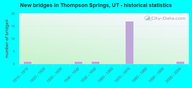
- New bridges - historical statistics
- 11910-1919
- 11940-1949
- 11950-1959
- 171970-1979
- 12000-2009


- Bridge Condition - Deck
- 55.6%Good
- 33.3%Satisfactory
- 11.1%Fair

- Bridge Condition - Superstructure
- 11.1%Very good
- 22.2%Good
- 55.6%Satisfactory
- 11.1%Fair

- Bridge Condition - Substructure
- 11.1%Good
- 44.4%Satisfactory
- 44.4%Fair

- Bridge Condition - Channel
- 45.5%Good
- 45.5%Satisfactory
- 9.1%Fair

- Bridge Condition - Culverts
- 50.0%Good
- 50.0%Satisfactory
Find on map >> Show street view
Structure Number: 19019F, Location: WEST OF THOMPSON (Lat: 38.971433, Lng: -109.717561), Route carried "on" structure: County highway , Year Built: 2006, Status: Open, Structure Length: 4.71m (15.45ft), Average Daily Traffic: 12 (year 2020), Average Future Daily Traffic: 15 (year 2040), Design Load: HL 93, Features Intersected: THOMPSON WASH, Facility Carried by Structure: COUNTY ROAD
Minimum Vertical Clearance: 30+ m (98+ ft), Kilometerpoint: 0.447, Lanes on structure: 2, Owner: County Highway Agency, Approaching Roadway Width: 8.5m (27.9ft), Skew: 3 degrees, Material/Design: Prestressed concrete, Design/Construction: Stringer/Multi-beam, Number Of Spans In Main Unit: 1, Length of Maximum Span: 45.7m (149.9ft), Curb-To-Curb Width: 8.5m (27.9ft), Out-to-Out Width: 9.6m (31.5ft)
Condition: Deck: Good, Superstructure: Very good, Substructure: Good, Channel: Good, Operating Rating: 70.0 metric tons, Method Used To Determine Operating Rating: Load and Resistance Factor Rating (LRFR) rating reported by rating factor(RF) method using HL-93 loadings, Inventory Rating: 48.0 metric tons, Method Used To Determine Inventory Rating: Load and Resistance Factor Rating (LRFR) rating reported by rating factor(RF) method using HL-93 loadings, Structural Evaluation: Better than present minimum criteria, Deck Geometry: Better than present minimum criteria, Waterway Adequacy: Better than present minimum criteria, Approach Roadway Alignment: Equal to present desirable criteria, Designated Inspection Frequency: Every 24 months, Inspection Date: January 2022, Deck Structure Type: Concrete Cast-file-Place, Wearing Surface/Protective System: Deck Protection: Epoxy Coated Reinforcing
Find on map >> Show street view
Structure Number: 19020C, Location: 1.5 MI. SW. OF THOMPSON (Lat: 38.963681, Lng: -109.724906), Route carried "on" structure: County highway , Year Built: 1919, Status: Open, Structure Length: 1.00m (3.28ft), Average Daily Traffic: 26 (year 2020), Average Future Daily Traffic: 30 (year 2040), Design Load: H 15, Features Intersected: THOMPSON WASH, Facility Carried by Structure: COUNTY ROAD
Minimum Vertical Clearance: 30+ m (98+ ft), Kilometerpoint: 0.020, Lanes on structure: 1, Owner: County Highway Agency, Approaching Roadway Width: 4.9m (16.1ft), Skew: 4 degrees, Material/Design: Steel, Design/Construction: Stringer/Multi-beam, Number Of Spans In Main Unit: 1, Length of Maximum Span: 9.0m (29.5ft), Curb-To-Curb Width: 4.9m (16.1ft), Out-to-Out Width: 5.6m (18.4ft)
Condition: Deck: Fair, Superstructure: Satisfactory, Substructure: Satisfactory, Channel: Fair, Operating Rating: 46.7 metric tons, Method Used To Determine Operating Rating: Load Factor (LF) rating reported by rating factor (RF) method using MS18 loading, Inventory Rating: 33.7 metric tons, Method Used To Determine Inventory Rating: Load Factor (LF) rating reported by rating factor (RF) method using MS18 loading, Structural Evaluation: Equal to present minimum criteria, Deck Geometry: High priority of corrective action, Waterway Adequacy: Equal to present minimum criteria, Approach Roadway Alignment: Equal to present desirable criteria, Designated Inspection Frequency: Every 24 months, Inspection Date: January 2022, Deck Structure Type: Concrete Cast-file-Place, Wearing Surface/Protective System: Wearing Surface: Bituminous
Find on map >> Show street view
Structure Number: 19028E, Location: 4.5 MILES E. OF THOMPSON (Lat: 38.952083, Lng: -109.658422), Route carried "on" structure: County highway 1702, Year Built: 1947, Status: Open, Structure Length: 1.21m (3.97ft), Average Daily Traffic: 1,100 (year 2020), Average Future Daily Traffic: 1,375 (year 2040), Design Load: H 15, Features Intersected: BOOTLEGGER WASH, Facility Carried by Structure: COUNTY ROAD
Minimum Vertical Clearance: 30+ m (98+ ft), Kilometerpoint: 5.721, Lanes on structure: 2, Owner: County Highway Agency, Approaching Roadway Width: 7.3m (24.0ft), Skew: 6 degrees, Material/Design: Concrete, Design/Construction: Culvert, Number Of Spans In Main Unit: 1, Length of Maximum Span: 10.3m (33.8ft)
Condition: Channel: Satisfactory, Culverts: Satisfactory, Operating Rating: 48.6 metric tons, Method Used To Determine Operating Rating: Load and Resistance Factor Rating (LRFR) rating reported by rating factor(RF) method using HL-93 loadings, Inventory Rating: 48.3 metric tons, Method Used To Determine Inventory Rating: Load and Resistance Factor Rating (LRFR) rating reported by rating factor(RF) method using HL-93 loadings, Structural Evaluation: Equal to present minimum criteria, Waterway Adequacy: Better than present minimum criteria, Approach Roadway Alignment: Equal to present desirable criteria, Designated Inspection Frequency: Every 24 months, Inspection Date: January 2022
Find on map >> Show street view
Structure Number: 19029D, Location: 6 MILES EAST OF THOMPSON (Lat: 38.948856, Lng: -109.616769), Route carried "on" structure: County highway , Year Built: 1950, Status: Open, Structure Length: 2.65m (8.69ft), Average Daily Traffic: 13 (year 2020), Average Future Daily Traffic: 15 (year 2040), Design Load: H 15, Features Intersected: SAGER'S WASH, Facility Carried by Structure: COUNTY ROAD
Minimum Vertical Clearance: 30+ m (98+ ft), Kilometerpoint: 0.457, Lanes on structure: 2, Owner: County Highway Agency, Approaching Roadway Width: 7.9m (25.9ft), Material/Design: Concrete continuous, Design/Construction: Frame, Number Of Spans In Main Unit: 2, Length of Maximum Span: 12.2m (40.0ft), Curb or Sidewalk Widths: Left: 0.6m (2.0ft), Right: 0.6m (2.0ft), Curb-To-Curb Width: 7.9m (25.9ft), Out-to-Out Width: 9.8m (32.2ft)
Condition: Deck: Satisfactory, Superstructure: Satisfactory, Substructure: Satisfactory, Channel: Good, Operating Rating: 32.4 metric tons, Method Used To Determine Operating Rating: Load Factor (LF) rating reported by rating factor (RF) method using MS18 loading, Inventory Rating: 18.8 metric tons, Method Used To Determine Inventory Rating: Load Factor (LF) rating reported by rating factor (RF) method using MS18 loading, Structural Evaluation: Somewhat better than minimum adequacy, Deck Geometry: Equal to present minimum criteria, Waterway Adequacy: Better than present minimum criteria, Approach Roadway Alignment: Equal to present desirable criteria, Designated Inspection Frequency: Every 24 months, Inspection Date: January 2022, Deck Structure Type: Concrete Cast-file-Place, Wearing Surface/Protective System: Wearing Surface: Bituminous
Find on map >> Show street view
Structure Number: F 328A, Location: YELLOW CAT INT. (Lat: 38.941589, Lng: -109.614767), Route carried "on" structure: County highway 1702, Year Built: 1974, Status: Open, Structure Length: 5.26m (17.26ft), Average Daily Traffic: 1,100 (year 2020), Average Future Daily Traffic: 1,375 (year 2040), Design Load: HS 20+Mod, Features Intersected: I-70 (SR-70) EBL, Facility Carried by Structure: CO. RD., INT.
Minimum Vertical Clearance: 30+ m (98+ ft), Kilometerpoint: 10.010, Lanes on structure: 2, Lanes under structure: 2, Owner: State Highway Agency, Approaching Roadway Width: 9.3m (30.5ft), Material/Design: Prestressed concrete, Design/Construction: Stringer/Multi-beam, Number Of Spans In Main Unit: 3, Length of Maximum Span: 26.5m (86.9ft), Curb-To-Curb Width: 9.3m (30.5ft), Out-to-Out Width: 10.4m (34.1ft)
Condition: Deck: Good, Superstructure: Good, Substructure: Satisfactory, Operating Rating: 37.6 metric tons, Method Used To Determine Operating Rating: Load and Resistance Factor Rating (LRFR) rating reported by rating factor(RF) method using HL-93 loadings, Inventory Rating: 24.0 metric tons, Method Used To Determine Inventory Rating: Load Factor (LF) rating reported by rating factor (RF) method using MS18 loading, Structural Evaluation: Equal to present minimum criteria, Deck Geometry: Somewhat better than minimum adequacy, Underclear: Better than present minimum criteria, Approach Roadway Alignment: Equal to present desirable criteria, Designated Inspection Frequency: Every 24 months, Inspection Date: September 2021, Deck Structure Type: Concrete Cast-file-Place, Wearing Surface/Protective System: Wearing Surface: Bituminous, Membrane: Preformed Fabric
Find on map >> Show street view
Structure Number: F 328B, Location: YELLOW CAT INTERCHANGE (Lat: 38.942522, Lng: -109.614753), Route carried "on" structure: County highway 1702, Year Built: 1974, Status: Open, Structure Length: 5.26m (17.26ft), Average Daily Traffic: 1,100 (year 2020), Average Future Daily Traffic: 1,375 (year 2040), Design Load: HS 20+Mod, Features Intersected: I-70 (SR-70) WBL, Facility Carried by Structure: CO.RD.,INTCHG.X-RD
Minimum Vertical Clearance: 30+ m (98+ ft), Kilometerpoint: 9.906, Lanes on structure: 2, Lanes under structure: 2, Owner: State Highway Agency, Approaching Roadway Width: 9.3m (30.5ft), Material/Design: Prestressed concrete, Design/Construction: Stringer/Multi-beam, Number Of Spans In Main Unit: 3, Length of Maximum Span: 26.5m (86.9ft), Curb-To-Curb Width: 9.3m (30.5ft), Out-to-Out Width: 10.4m (34.1ft)
Condition: Deck: Good, Superstructure: Good, Substructure: Satisfactory, Operating Rating: 37.6 metric tons, Method Used To Determine Operating Rating: Load and Resistance Factor Rating (LRFR) rating reported by rating factor(RF) method using HL-93 loadings, Inventory Rating: 24.0 metric tons, Method Used To Determine Inventory Rating: Load Factor (LF) rating reported by rating factor (RF) method using MS18 loading, Structural Evaluation: Equal to present minimum criteria, Deck Geometry: Somewhat better than minimum adequacy, Underclear: Better than present minimum criteria, Approach Roadway Alignment: Equal to present desirable criteria, Designated Inspection Frequency: Every 24 months, Inspection Date: September 2021, Deck Structure Type: Concrete Cast-file-Place, Wearing Surface/Protective System: Wearing Surface: Bituminous, Membrane: Preformed Fabric
Find on map >> Show street view
Structure Number: V1267, Location: 4 MI. E. OF THOMPSON INT. (Lat: 38.945197, Lng: -109.650908), Route carried "on" structure: Interstate 70, Year Built: 1975, Status: Open, Structure Length: 1.09m (3.58ft), Average Daily Traffic: 8,170 (year 2020), Truck Traffic: 47%, Average Future Daily Traffic: 10,213 (year 2040), Design Load: HS 20+Mod, Features Intersected: SALT WASH
Minimum Vertical Clearance: 30+ m (98+ ft), Kilometerpoint: 308.471, Lanes on structure: 4, Base Highway Network: Yes, Owner: State Highway Agency, Approaching Roadway Width: 25.6m (84.0ft), Skew: 23 degrees, Material/Design: Steel, Design/Construction: Culvert, Number Of Spans In Main Unit: 2, Length of Maximum Span: 4.7m (15.4ft)
Condition: Channel: Good, Culverts: Satisfactory, Operating Rating: 97.2 metric tons, Method Used To Determine Operating Rating: Load and Resistance Factor Rating (LRFR) rating reported by rating factor(RF) method using HL-93 loadings, Inventory Rating: 96.9 metric tons, Method Used To Determine Inventory Rating: Load and Resistance Factor Rating (LRFR) rating reported by rating factor(RF) method using HL-93 loadings, Structural Evaluation: Equal to present minimum criteria, Waterway Adequacy: Better than present minimum criteria, Approach Roadway Alignment: Equal to present desirable criteria, Designated Inspection Frequency: Every 24 months, Inspection Date: September 2021
Find on map >> Show street view
Structure Number: 2F 337, Location: THOMPSON INTERCHANGE (Lat: 38.961550, Lng: -109.722428), Route carried "on" structure: Interstate 70, Year Built: 1975, Status: Open, Structure Length: 2.80m (9.19ft), Average Daily Traffic: 9,592 (year 2020), Truck Traffic: 45%, Average Future Daily Traffic: 11,990 (year 2040), Design Load: HS 20+Mod, Features Intersected: SR-94, INTCHG X-RD
Minimum Vertical Clearance: 30+ m (98+ ft), Kilometerpoint: 301.859, Lanes on structure: 2, Lanes under structure: 2, Base Highway Network: Yes, Owner: State Highway Agency, Approaching Roadway Width: 12.5m (41.0ft), Skew: 10 degrees, Material/Design: Prestressed concrete, Design/Construction: Stringer/Multi-beam, Number Of Spans In Main Unit: 1, Length of Maximum Span: 28.0m (91.9ft), Curb-To-Curb Width: 12.5m (41.0ft), Out-to-Out Width: 13.6m (44.6ft)
Condition: Deck: Good, Superstructure: Satisfactory, Substructure: Fair, Operating Rating: 68.0 metric tons, Method Used To Determine Operating Rating: Load and Resistance Factor Rating (LRFR) rating reported by rating factor(RF) method using HL-93 loadings, Inventory Rating: 29.2 metric tons, Method Used To Determine Inventory Rating: Load Factor (LF) rating reported by rating factor (RF) method using MS18 loading, Structural Evaluation: Somewhat better than minimum adequacy, Deck Geometry: Better than present minimum criteria, Underclear: Meets minimum limits, Approach Roadway Alignment: Equal to present desirable criteria, Designated Inspection Frequency: Every 24 months, Inspection Date: September 2021, Deck Structure Type: Concrete Cast-file-Place, Wearing Surface/Protective System: Wearing Surface: Bituminous, Membrane: Preformed Fabric
Find on map >> Show street view
Structure Number: 2F 339, Location: .6 MI.W.OF THOMPSON INT (Lat: 38.959378, Lng: -109.732494), Route carried "on" structure: Interstate 70, Year Built: 1975, Status: Open, Structure Length: 5.91m (19.39ft), Average Daily Traffic: 9,592 (year 2020), Truck Traffic: 45%, Average Future Daily Traffic: 11,990 (year 2040), Design Load: HS 20+Mod, Features Intersected: CO.RD. & THOMPSON WA
Minimum Vertical Clearance: 30+ m (98+ ft), Kilometerpoint: 300.954, Lanes on structure: 2, Lanes under structure: 2, Base Highway Network: Yes, Owner: State Highway Agency, Approaching Roadway Width: 12.3m (40.4ft), Skew: 13 degrees, Material/Design: Prestressed concrete continuous, Design/Construction: Stringer/Multi-beam, Number Of Spans In Main Unit: 2, Length of Maximum Span: 29.1m (95.5ft), Curb-To-Curb Width: 12.3m (40.4ft), Out-to-Out Width: 13.4m (44.0ft)
Condition: Deck: Satisfactory, Superstructure: Satisfactory, Substructure: Fair, Channel: Satisfactory, Operating Rating: 37.3 metric tons, Method Used To Determine Operating Rating: Load and Resistance Factor Rating (LRFR) rating reported by rating factor(RF) method using HL-93 loadings, Inventory Rating: 35.3 metric tons, Method Used To Determine Inventory Rating: Load Factor (LF) rating reported by rating factor (RF) method using MS18 loading, Structural Evaluation: Somewhat better than minimum adequacy, Deck Geometry: Better than present minimum criteria, Underclear: High priority of corrective action, Waterway Adequacy: Better than present minimum criteria, Approach Roadway Alignment: Equal to present desirable criteria, Designated Inspection Frequency: Every 24 months, Inspection Date: September 2021, Deck Structure Type: Concrete Cast-file-Place, Wearing Surface/Protective System: Wearing Surface: Bituminous, Membrane: Preformed Fabric
Find on map >> Show street view
Structure Number: 2V1219, Location: 0.5 MI.E.YELLOWCAT INTER. (Lat: 38.941825, Lng: -109.603139), Route carried "on" structure: Interstate 70, Year Built: 1974, Status: Open, Structure Length: 1.46m (4.79ft), Average Daily Traffic: 10,513 (year 2020), Truck Traffic: 48%, Average Future Daily Traffic: 13,141 (year 2040), Design Load: HS 20+Mod, Features Intersected: SAGER'S WASH
Minimum Vertical Clearance: 30+ m (98+ ft), Kilometerpoint: 312.645, Lanes on structure: 2, Base Highway Network: Yes, Owner: State Highway Agency, Approaching Roadway Width: 13.1m (43.0ft), Skew: 13 degrees, Material/Design: Steel, Design/Construction: Culvert, Number Of Spans In Main Unit: 2, Length of Maximum Span: 6.7m (22.0ft)
Condition: Channel: Good, Culverts: Good, Operating Rating: 97.2 metric tons, Method Used To Determine Operating Rating: Load and Resistance Factor Rating (LRFR) rating reported by rating factor(RF) method using HL-93 loadings, Inventory Rating: 96.9 metric tons, Method Used To Determine Inventory Rating: Load and Resistance Factor Rating (LRFR) rating reported by rating factor(RF) method using HL-93 loadings, Structural Evaluation: Better than present minimum criteria, Waterway Adequacy: Equal to present minimum criteria, Approach Roadway Alignment: Equal to present desirable criteria, Designated Inspection Frequency: Every 24 months, Inspection Date: September 2021
Find on map >> Show street view
Structure Number: 2V1264, Location: 1 MI. W. THOMPSON INT. (Lat: 38.957189, Lng: -109.742586), Route carried "on" structure: Interstate 70, Year Built: 1976, Status: Open, Structure Length: 0.98m (3.22ft), Average Daily Traffic: 9,592 (year 2020), Truck Traffic: 45%, Average Future Daily Traffic: 11,990 (year 2040), Design Load: H 15, Features Intersected: BLAZE CANYON WASH
Minimum Vertical Clearance: 30+ m (98+ ft), Kilometerpoint: 300.046, Lanes on structure: 2, Base Highway Network: Yes, Owner: State Highway Agency, Approaching Roadway Width: 12.2m (40.0ft), Material/Design: Steel, Design/Construction: Culvert, Number Of Spans In Main Unit: 2, Length of Maximum Span: 4.1m (13.5ft)
Condition: Channel: Good, Culverts: Good, Operating Rating: 97.2 metric tons, Method Used To Determine Operating Rating: Load and Resistance Factor Rating (LRFR) rating reported by rating factor(RF) method using HL-93 loadings, Inventory Rating: 96.9 metric tons, Method Used To Determine Inventory Rating: Load and Resistance Factor Rating (LRFR) rating reported by rating factor(RF) method using HL-93 loadings, Structural Evaluation: Better than present minimum criteria, Waterway Adequacy: Better than present minimum criteria, Approach Roadway Alignment: Equal to present desirable criteria, Designated Inspection Frequency: Every 24 months, Inspection Date: September 2021
Find on map >> Show street view
Structure Number: 4F 337, Location: THOMPSON INTERCHANGE (Lat: 38.962211, Lng: -109.722097), Route carried "on" structure: Interstate 70, Year Built: 1975, Status: Open, Structure Length: 2.80m (9.19ft), Average Daily Traffic: 8,170 (year 2020), Truck Traffic: 47%, Average Future Daily Traffic: 10,213 (year 2040), Design Load: HS 20+Mod, Features Intersected: SR-94, INTCHG. X-RD
Minimum Vertical Clearance: 30+ m (98+ ft), Kilometerpoint: 301.919, Lanes on structure: 2, Lanes under structure: 2, Base Highway Network: Yes, Owner: State Highway Agency, Approaching Roadway Width: 12.5m (41.0ft), Skew: 10 degrees, Material/Design: Prestressed concrete, Design/Construction: Stringer/Multi-beam, Number Of Spans In Main Unit: 1, Length of Maximum Span: 28.0m (91.9ft), Curb-To-Curb Width: 12.5m (41.0ft), Out-to-Out Width: 13.6m (44.6ft)
Condition: Deck: Satisfactory, Superstructure: Satisfactory, Substructure: Fair, Operating Rating: 69.7 metric tons, Method Used To Determine Operating Rating: Load and Resistance Factor Rating (LRFR) rating reported by rating factor(RF) method using HL-93 loadings, Inventory Rating: 30.8 metric tons, Method Used To Determine Inventory Rating: Load Factor (LF) rating reported by rating factor (RF) method using MS18 loading, Structural Evaluation: Somewhat better than minimum adequacy, Deck Geometry: Better than present minimum criteria, Underclear: Meets minimum limits, Approach Roadway Alignment: Equal to present desirable criteria, Designated Inspection Frequency: Every 24 months, Inspection Date: September 2021, Deck Structure Type: Concrete Cast-file-Place, Wearing Surface/Protective System: Wearing Surface: Bituminous, Membrane: Preformed Fabric
Find on map >> Show street view
Structure Number: 4F 339, Location: 0.6 MI.W.OF THOMPSON INT (Lat: 38.960358, Lng: -109.731569), Route carried "on" structure: Interstate 70, Year Built: 1975, Status: Open, Structure Length: 5.91m (19.39ft), Average Daily Traffic: 9,592 (year 2020), Truck Traffic: 45%, Average Future Daily Traffic: 11,990 (year 2040), Design Load: HS 20+Mod, Features Intersected: CO.RD. & THOMPSON WA
Minimum Vertical Clearance: 30+ m (98+ ft), Kilometerpoint: 301.072, Lanes on structure: 2, Lanes under structure: 2, Base Highway Network: Yes, Owner: State Highway Agency, Approaching Roadway Width: 17.0m (55.8ft), Skew: 13 degrees, Material/Design: Prestressed concrete continuous, Design/Construction: Stringer/Multi-beam, Number Of Spans In Main Unit: 2, Length of Maximum Span: 29.1m (95.5ft), Curb-To-Curb Width: 17.0m (55.8ft), Out-to-Out Width: 18.1m (59.4ft)
Condition: Deck: Good, Superstructure: Fair, Substructure: Fair, Channel: Satisfactory, Operating Rating: 45.4 metric tons, Method Used To Determine Operating Rating: Load and Resistance Factor Rating (LRFR) rating reported by rating factor(RF) method using HL-93 loadings, Inventory Rating: 36.3 metric tons, Method Used To Determine Inventory Rating: Load Factor (LF) rating reported by rating factor (RF) method using MS18 loading, Structural Evaluation: Somewhat better than minimum adequacy, Deck Geometry: Superior to present desirable criteria, Underclear: High priority of corrective action, Waterway Adequacy: Somewhat better than minimum adequacy, Approach Roadway Alignment: Equal to present desirable criteria, Designated Inspection Frequency: Every 24 months, Inspection Date: September 2021, Deck Structure Type: Concrete Cast-file-Place, Wearing Surface/Protective System: Wearing Surface: Bituminous, Membrane: Preformed Fabric
Find on map >> Show street view
Structure Number: 4V1219, Location: 0.5 MI.E.YELLOWCAT INTER. (Lat: 38.942800, Lng: -109.603767), Route carried "on" structure: Interstate 70, Year Built: 1974, Status: Open, Structure Length: 1.25m (4.10ft), Average Daily Traffic: 10,513 (year 2020), Truck Traffic: 48%, Average Future Daily Traffic: 13,141 (year 2040), Design Load: HS 20+Mod, Features Intersected: SAGER'S WASH
Minimum Vertical Clearance: 30+ m (98+ ft), Kilometerpoint: 312.595, Lanes on structure: 2, Base Highway Network: Yes, Owner: State Highway Agency, Approaching Roadway Width: 13.1m (43.0ft), Skew: 13 degrees, Material/Design: Steel, Design/Construction: Culvert, Number Of Spans In Main Unit: 2, Length of Maximum Span: 5.6m (18.4ft)
Condition: Channel: Satisfactory, Culverts: Satisfactory, Operating Rating: 97.2 metric tons, Method Used To Determine Operating Rating: Load and Resistance Factor Rating (LRFR) rating reported by rating factor(RF) method using HL-93 loadings, Inventory Rating: 96.9 metric tons, Method Used To Determine Inventory Rating: Load and Resistance Factor Rating (LRFR) rating reported by rating factor(RF) method using HL-93 loadings, Structural Evaluation: Equal to present minimum criteria, Waterway Adequacy: Equal to present minimum criteria, Approach Roadway Alignment: Equal to present desirable criteria, Designated Inspection Frequency: Every 24 months, Inspection Date: September 2021
Find on map >> Show street view
Structure Number: 4V1264, Location: 1 MI.WEST THOMPSON INTER. (Lat: 38.957878, Lng: -109.742828), Route carried "on" structure: Interstate 70, Year Built: 1976, Status: Open, Structure Length: 0.96m (3.15ft), Average Daily Traffic: 9,592 (year 2020), Truck Traffic: 45%, Average Future Daily Traffic: 11,990 (year 2040), Design Load: H 15, Features Intersected: BLAZE CANYON WASH
Minimum Vertical Clearance: 30+ m (98+ ft), Kilometerpoint: 300.058, Lanes on structure: 2, Base Highway Network: Yes, Owner: State Highway Agency, Approaching Roadway Width: 12.2m (40.0ft), Skew: 10 degrees, Material/Design: Steel, Design/Construction: Culvert, Number Of Spans In Main Unit: 2, Length of Maximum Span: 4.1m (13.5ft)
Condition: Channel: Satisfactory, Culverts: Good, Operating Rating: 97.2 metric tons, Method Used To Determine Operating Rating: Load and Resistance Factor Rating (LRFR) rating reported by rating factor(RF) method using HL-93 loadings, Inventory Rating: 96.9 metric tons, Method Used To Determine Inventory Rating: Load and Resistance Factor Rating (LRFR) rating reported by rating factor(RF) method using HL-93 loadings, Structural Evaluation: Better than present minimum criteria, Waterway Adequacy: Better than present minimum criteria, Approach Roadway Alignment: Equal to present desirable criteria, Designated Inspection Frequency: Every 24 months, Inspection Date: September 2021
Find on map >> Show street view
Structure Number: F 328A, Location: YELLOW CAT INT. (Lat: 38.941589, Lng: -109.614767), Route carried "under" structure: Interstate 70, Year Built: 1974, Structure Length: 0. m, Average Daily Traffic: 8,170 (year 2020), Truck Traffic: 47%, Features Intersected: I-70 (SR-70) EBL, Facility Carried by Structure: CO. RD., INT.
Minimum Vertical Clearance: 5.19m (17.03ft), Kilometerpoint: 311.630, Lanes on structure: 2, Lanes under structure: 2, Material/Design: Prestressed concrete, Design/Construction: Stringer/Multi-beam, Length of Maximum Span: 26.5m (86.9ft)
Find on map >> Show street view
Structure Number: F 328B, Location: YELLOW CAT INTERCHANGE (Lat: 38.942522, Lng: -109.614753), Route carried "under" structure: Interstate 70, Year Built: 1974, Structure Length: 0. m, Average Daily Traffic: 10,513 (year 2020), Truck Traffic: 48%, Features Intersected: I-70 (SR-70) WBL, Facility Carried by Structure: CO.RD.,INTCHG.X-RD
Minimum Vertical Clearance: 5.13m (16.83ft), Kilometerpoint: 311.645, Lanes on structure: 2, Lanes under structure: 2, Material/Design: Prestressed concrete, Design/Construction: Stringer/Multi-beam, Length of Maximum Span: 26.5m (86.9ft)
Find on map >> Show street view
Structure Number: 2F 337, Location: THOMPSON INTERCHANGE (Lat: 38.961550, Lng: -109.722428), Route carried "under" structure: State highway 94, Year Built: 1975, Structure Length: 0. m, Average Daily Traffic: 931 (year 2020), Truck Traffic: 52%, Features Intersected: SR-94, INTCHG X-RD, Facility Carried by Structure: I-70 (SR-70) EBL
Minimum Vertical Clearance: 4.98m (16.34ft), Kilometerpoint: 0.087, Lanes on structure: 2, Lanes under structure: 2, Material/Design: Prestressed concrete, Design/Construction: Stringer/Multi-beam, Length of Maximum Span: 28.0m (91.9ft)
Find on map >> Show street view
Structure Number: 2F 339, Location: .6 MI.W.OF THOMPSON INT (Lat: 38.959378, Lng: -109.732494), Route carried "under" structure: County highway , Year Built: 1975, Structure Length: 0. m, Features Intersected: CO.RD. & THOMPSON WA, Facility Carried by Structure: I-70 (SR-70) EBL
Minimum Vertical Clearance: 4.66m (15.29ft), Kilometerpoint: 3.648, Lanes on structure: 2, Lanes under structure: 2, Material/Design: Prestressed concrete continuous, Design/Construction: Stringer/Multi-beam, Length of Maximum Span: 29.1m (95.5ft)
Find on map >> Show street view
Structure Number: 4F 337, Location: THOMPSON INTERCHANGE (Lat: 38.962211, Lng: -109.722097), Route carried "under" structure: State highway 94, Year Built: 1975, Structure Length: 0. m, Average Daily Traffic: 931 (year 2020), Truck Traffic: 52%, Features Intersected: SR-94, INTCHG. X-RD, Facility Carried by Structure: I-70 (SR-70) WBL
Minimum Vertical Clearance: 4.93m (16.17ft), Kilometerpoint: 0.148, Lanes on structure: 2, Lanes under structure: 2, Material/Design: Prestressed concrete, Design/Construction: Stringer/Multi-beam, Length of Maximum Span: 28.0m (91.9ft)
Find on map >> Show street view
Structure Number: 4F 339, Location: 0.6 MI.W.OF THOMPSON INT (Lat: 38.960358, Lng: -109.731569), Route carried "under" structure: County highway , Year Built: 1975, Structure Length: 0. m, Average Daily Traffic: 10 (year 2020), Features Intersected: CO.RD. & THOMPSON WA, Facility Carried by Structure: I-70 (SR-70) WBL
Minimum Vertical Clearance: 4.84m (15.88ft), Kilometerpoint: 0.080, Lanes on structure: 2, Lanes under structure: 2, Material/Design: Prestressed concrete continuous, Design/Construction: Stringer/Multi-beam, Length of Maximum Span: 29.1m (95.5ft)