Bridge Statistics for Thomasboro, Illinois (IL)
Condition, Traffic, Stress, Structural Evaluation, Project Costs
- National Bridge Inventory (NBI) Statistics
- 31Number of bridges
- 184ft / 55.7mTotal length
- 188,020Total average daily traffic
- 46,294Total average daily truck traffic
- National Bridge Inventory (NBI) Registered Bridges for Thomasboro
- No street view available for this location
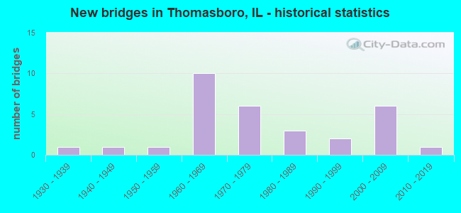
- New bridges - historical statistics
- 11930-1939
- 11940-1949
- 11950-1959
- 101960-1969
- 61970-1979
- 31980-1989
- 21990-1999
- 62000-2009
- 12010-2019


- Bridge Condition - Deck
- 22.7%Very good
- 59.1%Good
- 9.1%Satisfactory
- 4.5%Fair
- 4.5%Serious

- Bridge Condition - Superstructure
- 22.7%Very good
- 54.5%Good
- 13.6%Satisfactory
- 4.5%Fair
- 4.5%Poor

- Bridge Condition - Substructure
- 54.5%Very good
- 22.7%Good
- 4.5%Satisfactory
- 18.2%Fair

- Bridge Condition - Channel
- 37.0%Very good
- 37.0%Good
- 25.9%Satisfactory

- Bridge Condition - Culverts
- 14.3%Good
- 42.9%Satisfactory
- 42.9%Fair
Find on map >> Show street view
Structure Number: 100042, Location: S EDGE THOMASBORO (Lat: 40.233075, Lng: -88.183025), Route carried "on" structure: US 45, Year Built: 1955, Status: Open, Structure Length: 0.85m (2.79ft), Average Daily Traffic: 8,450 (year 2021), Truck Traffic: 9%, Average Future Daily Traffic: 5,330 (year 2032), Design Load: H 20, Features Intersected: DITCH
Minimum Vertical Clearance: 30+ m (98+ ft), Kilometerpoint: 412.592, Lanes on structure: 2, Base Highway Network: Yes, Owner: State Highway Agency, Approaching Roadway Width: 9.8m (32.2ft), Material/Design: Concrete, Design/Construction: Tee Beam, Number Of Spans In Main Unit: 1, Length of Maximum Span: 8.2m (26.9ft), Curb-To-Curb Width: 14.3m (46.9ft), Out-to-Out Width: 14.8m (48.6ft)
Condition: Deck: Satisfactory, Superstructure: Satisfactory, Substructure: Satisfactory, Channel: Good, Operating Rating: 62.9 metric tons, Method Used To Determine Operating Rating: Load Factor (LF) rating reported by rating factor (RF) method using MS18 loading, Inventory Rating: 37.9 metric tons, Method Used To Determine Inventory Rating: Load Factor (LF) rating reported by rating factor (RF) method using MS18 loading, Structural Evaluation: Equal to present minimum criteria, Deck Geometry: Superior to present desirable criteria, Waterway Adequacy: Better than present minimum criteria, Approach Roadway Alignment: Equal to present desirable criteria, Designated Inspection Frequency: Every 24 months, Inspection Date: November 2021, Deck Structure Type: Concrete Cast-file-Place, Wearing Surface/Protective System: Wearing Surface: Bituminous, Membrane: Built-up
Find on map >> Show street view
Structure Number: 100043, Location: S EDGE THOMASBORO (Lat: 40.232931, Lng: -88.183019), Route carried "on" structure: US 45, Year Built: 1942, Status: Open, Structure Length: 0.85m (2.79ft), Average Daily Traffic: 8,450 (year 2021), Truck Traffic: 9%, Average Future Daily Traffic: 5,330 (year 2032), Design Load: H 20, Features Intersected: DITCH
Minimum Vertical Clearance: 30+ m (98+ ft), Kilometerpoint: 412.576, Lanes on structure: 2, Base Highway Network: Yes, Owner: State Highway Agency, Approaching Roadway Width: 9.8m (32.2ft), Material/Design: Concrete, Design/Construction: Tee Beam, Number Of Spans In Main Unit: 1, Length of Maximum Span: 8.2m (26.9ft), Curb-To-Curb Width: 14.3m (46.9ft), Out-to-Out Width: 14.8m (48.6ft)
Condition: Deck: Fair, Superstructure: Fair, Substructure: Fair, Channel: Good, Operating Rating: 55.1 metric tons, Method Used To Determine Operating Rating: Load Factor (LF) rating reported by rating factor (RF) method using MS18 loading, Inventory Rating: 33.0 metric tons, Method Used To Determine Inventory Rating: Load Factor (LF) rating reported by rating factor (RF) method using MS18 loading, Structural Evaluation: Somewhat better than minimum adequacy, Deck Geometry: Superior to present desirable criteria, Waterway Adequacy: Better than present minimum criteria, Approach Roadway Alignment: Equal to present desirable criteria, Designated Inspection Frequency: Every 24 months, Inspection Date: November 2021, Deck Structure Type: Concrete Cast-file-Place, Wearing Surface/Protective System: Wearing Surface: Bituminous, Membrane: Built-up
Find on map >> Show street view
Structure Number: 100156, Location: THOMASBORO (Lat: 40.238861, Lng: -88.197492), Route carried "on" structure: County highway , Year Built: 1967, Status: Posted for load, Structure Length: 6.80m (22.31ft), Average Daily Traffic: 1,150 (year 2021), Truck Traffic: 6%, Average Future Daily Traffic: 1,748 (year 2032), Design Load: HS 15, Features Intersected: I-57, Facility Carried by Structure: FAS 517
Minimum Vertical Clearance: 30+ m (98+ ft), Kilometerpoint: 8.465, Lanes on structure: 2, Lanes under structure: 4, Owner: State Highway Agency, Approaching Roadway Width: 9.8m (32.2ft), Material/Design: Steel continuous, Design/Construction: Stringer/Multi-beam, Number Of Spans In Main Unit: 4, Length of Maximum Span: 20.5m (67.3ft), Curb-To-Curb Width: 7.9m (25.9ft), Out-to-Out Width: 9.7m (31.8ft)
Condition: Deck: Serious, Superstructure: Poor, Substructure: Good, Operating Rating: 35.6 metric tons, Method Used To Determine Operating Rating: Load Factor (LF) rating reported by rating factor (RF) method using MS18 loading, Inventory Rating: 21.4 metric tons, Method Used To Determine Inventory Rating: Load Factor (LF) rating reported by rating factor (RF) method using MS18 loading, Structural Evaluation: Meets minimum limits, Deck Geometry: Meets minimum limits, Underclear: Meets minimum limits, Approach Roadway Alignment: Better than present minimum criteria, Bridge Posting: Required (Relationship of Operating Rating to Maximum Legal Load: 0.1 - 9.9% below), Designated Inspection Frequency: Every 12 months, Inspection Date: November 2021, Deck Structure Type: Concrete Cast-file-Place, Wearing Surface/Protective System: Wearing Surface: Bituminous, Membrane: Built-up
Find on map >> Show street view
Structure Number: 100172, Location: 1 MI N OF LEVERETT (Lat: 40.206033, Lng: -88.220811), Route carried "on" structure: County highway , Year Built: 1968, Status: Open, Structure Length: 10.70m (35.10ft), Average Daily Traffic: 375 (year 2021), Truck Traffic: 1%, Average Future Daily Traffic: 508 (year 2032), Design Load: HS 15, Features Intersected: I-57, Facility Carried by Structure: TR 170
Minimum Vertical Clearance: 30+ m (98+ ft), Kilometerpoint: 1.963, Lanes on structure: 2, Lanes under structure: 4, Owner: State Highway Agency, Approaching Roadway Width: 5.5m (18.0ft), Skew: 5 degrees, Material/Design: Steel continuous, Design/Construction: Stringer/Multi-beam, Number Of Spans In Main Unit: 4, Length of Maximum Span: 33.1m (108.6ft), Curb-To-Curb Width: 7.3m (24.0ft), Out-to-Out Width: 9.1m (29.9ft)
Condition: Deck: Good, Superstructure: Satisfactory, Substructure: Good, Operating Rating: 55.7 metric tons, Method Used To Determine Operating Rating: Allowable Stress (AS) rating reported by rating factor (RF) method using MS18 loading, Inventory Rating: 31.8 metric tons, Method Used To Determine Inventory Rating: Allowable Stress (AS) rating reported by rating factor (RF) method using MS18 loading, Structural Evaluation: Equal to present minimum criteria, Deck Geometry: Somewhat better than minimum adequacy, Underclear: Meets minimum limits, Approach Roadway Alignment: Better than present minimum criteria, Designated Inspection Frequency: Every 24 months, Inspection Date: November 2021, Deck Structure Type: Concrete Cast-file-Place
Find on map >> Show street view
Structure Number: 100184, Location: W OF THOMASBORO (Lat: 40.238772, Lng: -88.195950), Route carried "on" structure: City street , Year Built: 1936, Status: Open, Structure Length: 0.85m (2.79ft), Average Future Daily Traffic: 33 (year 2032), Features Intersected: STREAM, Facility Carried by Structure: CH 11 A
Minimum Vertical Clearance: 30+ m (98+ ft), Kilometerpoint: 0.290, Lanes on structure: 2, Owner: City or Municipal Highway Agency, Approaching Roadway Width: 5.8m (19.0ft), Skew: 1 degrees, Material/Design: Concrete, Design/Construction: Slab, Number Of Spans In Main Unit: 1, Length of Maximum Span: 8.2m (26.9ft), Curb-To-Curb Width: 9.1m (29.9ft), Out-to-Out Width: 10.1m (33.1ft)
Condition: Deck: Satisfactory, Superstructure: Satisfactory, Substructure: Good, Channel: Good, Operating Rating: 33.4 metric tons, Method Used To Determine Operating Rating: Allowable Stress (AS) rating reported by rating factor (RF) method using MS18 loading, Inventory Rating: 19.8 metric tons, Method Used To Determine Inventory Rating: Allowable Stress (AS) rating reported by rating factor (RF) method using MS18 loading, Structural Evaluation: Somewhat better than minimum adequacy, Deck Geometry: Better than present minimum criteria, Waterway Adequacy: Equal to present minimum criteria, Approach Roadway Alignment: High priority of corrective action, Designated Inspection Frequency: Every 24 months, Inspection Date: March 2021, Deck Structure Type: Concrete Cast-file-Place
Find on map >> Show street view
Structure Number: 100193, Location: 1.5 MI S THOMASBORO (Lat: 40.214744, Lng: -88.211219), Route carried "on" structure: Interstate 57, Year Built: 1969, Status: Open, Structure Length: 0.70m (2.30ft), Average Daily Traffic: 26,000 (year 2021), Truck Traffic: 28%, Average Future Daily Traffic: 24,139 (year 2032), Design Load: HS 20+Mod, Features Intersected: STREAM
Minimum Vertical Clearance: 30+ m (98+ ft), Kilometerpoint: 391.591, Lanes on structure: 4, Base Highway Network: Yes, Owner: State Highway Agency, Approaching Roadway Width: 23.2m (76.1ft), Skew: 11 degrees, Material/Design: Concrete continuous, Design/Construction: Culvert, Number Of Spans In Main Unit: 2, Length of Maximum Span: 3.4m (11.2ft)
Condition: Channel: Satisfactory, Culverts: Satisfactory, Operating Rating: 55.1 metric tons, Method Used To Determine Operating Rating: Load Factor (LF) rating reported by rating factor (RF) method using MS18 loading, Inventory Rating: 33.0 metric tons, Method Used To Determine Inventory Rating: Load Factor (LF) rating reported by rating factor (RF) method using MS18 loading, Structural Evaluation: Equal to present minimum criteria, Waterway Adequacy: Equal to present desirable criteria, Approach Roadway Alignment: Equal to present desirable criteria, Designated Inspection Frequency: Every 24 months, Inspection Date: November 2021
Find on map >> Show street view
Structure Number: 100226, Location: 4 MI S US 136 (Lat: 40.248136, Lng: -88.193075), Route carried "on" structure: Interstate 57, Year Built: 1969, Status: Open, Structure Length: 0.70m (2.30ft), Average Daily Traffic: 26,000 (year 2021), Truck Traffic: 28%, Average Future Daily Traffic: 24,139 (year 2032), Design Load: HS 20+Mod, Features Intersected: CARL BRANCH
Minimum Vertical Clearance: 30+ m (98+ ft), Kilometerpoint: 395.630, Lanes on structure: 4, Base Highway Network: Yes, Owner: State Highway Agency, Approaching Roadway Width: 23.2m (76.1ft), Skew: 13 degrees, Material/Design: Concrete continuous, Design/Construction: Culvert, Number Of Spans In Main Unit: 2, Length of Maximum Span: 3.4m (11.2ft)
Condition: Channel: Satisfactory, Culverts: Fair, Operating Rating: 55.4 metric tons, Method Used To Determine Operating Rating: Load Factor (LF) rating reported by rating factor (RF) method using MS18 loading, Inventory Rating: 33.4 metric tons, Method Used To Determine Inventory Rating: Load Factor (LF) rating reported by rating factor (RF) method using MS18 loading, Structural Evaluation: Somewhat better than minimum adequacy, Waterway Adequacy: Equal to present desirable criteria, Approach Roadway Alignment: Equal to present desirable criteria, Designated Inspection Frequency: Every 24 months, Inspection Date: November 2021
Find on map >> Show street view
Structure Number: 102001, Location: 2 MI N MARKET ST (Lat: 40.205428, Lng: -88.220658), Route carried "on" structure: Interstate 57, Year Built: 1969, Status: Open, Structure Length: 0.79m (2.59ft), Average Daily Traffic: 26,000 (year 2021), Truck Traffic: 28%, Average Future Daily Traffic: 24,139 (year 2032), Design Load: HS 20+Mod, Features Intersected: STREAM
Minimum Vertical Clearance: 30+ m (98+ ft), Kilometerpoint: 390.287, Lanes on structure: 4, Base Highway Network: Yes, Owner: State Highway Agency, Approaching Roadway Width: 23.2m (76.1ft), Skew: 11 degrees, Material/Design: Concrete continuous, Design/Construction: Culvert, Number Of Spans In Main Unit: 2, Length of Maximum Span: 3.8m (12.5ft)
Condition: Channel: Satisfactory, Culverts: Satisfactory, Operating Rating: 53.8 metric tons, Method Used To Determine Operating Rating: Load Factor (LF) rating reported by rating factor (RF) method using MS18 loading, Inventory Rating: 32.1 metric tons, Method Used To Determine Inventory Rating: Load Factor (LF) rating reported by rating factor (RF) method using MS18 loading, Structural Evaluation: Equal to present minimum criteria, Waterway Adequacy: Equal to present desirable criteria, Approach Roadway Alignment: Equal to present desirable criteria, Designated Inspection Frequency: Every 24 months, Inspection Date: November 2021
Find on map >> Show street view
Structure Number: 102002, Location: 1 MI S OF THOMABORO (Lat: 40.222056, Lng: -88.204331), Route carried "on" structure: Interstate 57, Year Built: 1968, Status: Open, Structure Length: 1.17m (3.84ft), Average Daily Traffic: 26,000 (year 2021), Truck Traffic: 28%, Average Future Daily Traffic: 24,139 (year 2032), Design Load: HS 20+Mod, Features Intersected: STREAM
Minimum Vertical Clearance: 30+ m (98+ ft), Kilometerpoint: 392.589, Lanes on structure: 4, Base Highway Network: Yes, Owner: State Highway Agency, Approaching Roadway Width: 23.2m (76.1ft), Skew: 14 degrees, Material/Design: Concrete continuous, Design/Construction: Culvert, Number Of Spans In Main Unit: 3, Length of Maximum Span: 3.7m (12.1ft)
Condition: Channel: Satisfactory, Culverts: Fair, Operating Rating: 66.7 metric tons, Method Used To Determine Operating Rating: Load Factor (LF) rating reported by rating factor (RF) method using MS18 loading, Inventory Rating: 40.2 metric tons, Method Used To Determine Inventory Rating: Load Factor (LF) rating reported by rating factor (RF) method using MS18 loading, Structural Evaluation: Somewhat better than minimum adequacy, Waterway Adequacy: Equal to present desirable criteria, Approach Roadway Alignment: Equal to present desirable criteria, Designated Inspection Frequency: Every 24 months, Inspection Date: November 2021
Find on map >> Show street view
Structure Number: 102013, Location: THOMASBORO (Lat: 40.238483, Lng: -88.195883), Route carried "on" structure: County highway , Year Built: 1967, Status: Open, Structure Length: 1.01m (3.31ft), Average Daily Traffic: 1,150 (year 2021), Truck Traffic: 6%, Average Future Daily Traffic: 1,748 (year 2032), Design Load: HS 15, Features Intersected: DRAINAGE DITCH, Facility Carried by Structure: CH 33
Minimum Vertical Clearance: 30+ m (98+ ft), Kilometerpoint: 8.610, Lanes on structure: 2, Owner: County Highway Agency, Approaching Roadway Width: 11.0m (36.1ft), Skew: 4 degrees, Material/Design: Concrete, Design/Construction: Culvert, Number Of Spans In Main Unit: 3, Length of Maximum Span: 3.0m (9.8ft)
Condition: Channel: Satisfactory, Culverts: Satisfactory, Operating Rating: 48.0 metric tons, Method Used To Determine Operating Rating: Load Factor (LF) rating reported by rating factor (RF) method using MS18 loading, Inventory Rating: 28.8 metric tons, Method Used To Determine Inventory Rating: Load Factor (LF) rating reported by rating factor (RF) method using MS18 loading, Structural Evaluation: Equal to present minimum criteria, Waterway Adequacy: Better than present minimum criteria, Approach Roadway Alignment: Equal to present desirable criteria, Designated Inspection Frequency: Every 24 months, Inspection Date: March 2021
Find on map >> Show street view
Structure Number: 102014, Location: 1.3 MI NW LEVERETT (Lat: 40.205717, Lng: -88.221414), Route carried "on" structure: County highway , Year Built: 1968, Status: Open, Structure Length: 0.76m (2.49ft), Average Daily Traffic: 50 (year 2021), Average Future Daily Traffic: 89 (year 2032), Design Load: HS 15, Features Intersected: BEAVER LAKE DRAINAGE, Facility Carried by Structure: TR 121
Minimum Vertical Clearance: 30+ m (98+ ft), Kilometerpoint: 9.913, Lanes on structure: 2, Owner: Town or Township Highway Agency, Approaching Roadway Width: 6.1m (20.0ft), Material/Design: Concrete, Design/Construction: Culvert, Number Of Spans In Main Unit: 2, Length of Maximum Span: 3.4m (11.2ft)
Condition: Channel: Good, Culverts: Good, Operating Rating: 40.5 metric tons, Method Used To Determine Operating Rating: Field evaluation and documented engineering judgment, Inventory Rating: 24.3 metric tons, Method Used To Determine Inventory Rating: Field evaluation and documented engineering judgment, Structural Evaluation: Equal to present minimum criteria, Waterway Adequacy: Better than present minimum criteria, Approach Roadway Alignment: Equal to present minimum criteria, Designated Inspection Frequency: Every 24 months, Inspection Date: Febuary 2020, Wearing Surface/Protective System: Wearing Surface: Gravel
Find on map >> Show street view
Structure Number: 102024, Location: 1.5 MI S THOMASBORO (Lat: 40.211269, Lng: -88.182567), Route carried "on" structure: US 45, Year Built: 1994, Status: Open, Structure Length: 1.70m (5.58ft), Average Daily Traffic: 8,450 (year 2021), Truck Traffic: 9%, Average Future Daily Traffic: 10,660 (year 2032), Design Load: HS 20+Mod, Features Intersected: SALINE BRANCH DITCH
Minimum Vertical Clearance: 30+ m (98+ ft), Kilometerpoint: 410.162, Lanes on structure: 4, Base Highway Network: Yes, Owner: State Highway Agency, Approaching Roadway Width: 18.3m (60.0ft), Skew: 4 degrees, Material/Design: Concrete continuous, Design/Construction: Culvert, Number Of Spans In Main Unit: 3, Length of Maximum Span: 5.5m (18.0ft)
Condition: Channel: Good, Culverts: Fair, Operating Rating: 64.8 metric tons, Method Used To Determine Operating Rating: Load Factor (LF) rating reported by rating factor (RF) method using MS18 loading, Inventory Rating: 38.9 metric tons, Method Used To Determine Inventory Rating: Load Factor (LF) rating reported by rating factor (RF) method using MS18 loading, Structural Evaluation: Somewhat better than minimum adequacy, Waterway Adequacy: Equal to present desirable criteria, Approach Roadway Alignment: Equal to present desirable criteria, Designated Inspection Frequency: Every 24 months, Inspection Date: November 2021
Find on map >> Show street view
Structure Number: 104003, Location: 2.8 MI SW THOMASBORO (Lat: 40.223975, Lng: -88.233525), Route carried "on" structure: County highway , Year Built: 1974, Status: Open, Structure Length: 1.21m (3.97ft), Average Daily Traffic: 75 (year 2021), Average Future Daily Traffic: 67 (year 2032), Design Load: HS 15, Features Intersected: STREAM, Facility Carried by Structure: TR 107
Minimum Vertical Clearance: 30+ m (98+ ft), Kilometerpoint: 1.738, Lanes on structure: 2, Owner: Town or Township Highway Agency, Approaching Roadway Width: 6.1m (20.0ft), Material/Design: Concrete, Design/Construction: Channel Beam, Number Of Spans In Main Unit: 1, Length of Maximum Span: 11.3m (37.1ft), Curb-To-Curb Width: 6.8m (22.3ft), Out-to-Out Width: 6.9m (22.6ft)
Condition: Deck: Good, Superstructure: Good, Substructure: Fair, Channel: Satisfactory, Operating Rating: 44.7 metric tons, Method Used To Determine Operating Rating: Load Factor (LF) rating reported by rating factor (RF) method using MS18 loading, Inventory Rating: 26.9 metric tons, Method Used To Determine Inventory Rating: Load Factor (LF) rating reported by rating factor (RF) method using MS18 loading, Structural Evaluation: Somewhat better than minimum adequacy, Deck Geometry: Somewhat better than minimum adequacy, Waterway Adequacy: Better than present minimum criteria, Approach Roadway Alignment: Equal to present minimum criteria, Designated Inspection Frequency: Every 24 months, Inspection Date: Febuary 2022, Deck Structure Type: Concrete Precast Panels, Wearing Surface/Protective System: Wearing Surface: Gravel, Membrane: Built-up
Find on map >> Show street view
Structure Number: 104022, Location: 1.0 MI N LEVERETT (Lat: 40.200242, Lng: -88.201672), Route carried "on" structure: County highway , Year Built: 1973, Status: Open, Structure Length: 1.86m (6.10ft), Average Daily Traffic: 175 (year 2021), Average Future Daily Traffic: 28 (year 2032), Design Load: HS 15, Features Intersected: STREAM, Facility Carried by Structure: TR 121 A
Minimum Vertical Clearance: 30+ m (98+ ft), Kilometerpoint: 1.996, Lanes on structure: 2, Owner: Town or Township Highway Agency, Approaching Roadway Width: 5.5m (18.0ft), Skew: 1 degrees, Material/Design: Concrete, Design/Construction: Channel Beam, Number Of Spans In Main Unit: 2, Length of Maximum Span: 8.9m (29.2ft), Curb-To-Curb Width: 7.9m (25.9ft), Out-to-Out Width: 8.1m (26.6ft)
Condition: Deck: Good, Superstructure: Good, Substructure: Good, Channel: Very good, Operating Rating: 61.9 metric tons, Method Used To Determine Operating Rating: Load Factor (LF) rating reported by rating factor (RF) method using MS18 loading, Inventory Rating: 37.3 metric tons, Method Used To Determine Inventory Rating: Load Factor (LF) rating reported by rating factor (RF) method using MS18 loading, Structural Evaluation: Better than present minimum criteria, Deck Geometry: Somewhat better than minimum adequacy, Waterway Adequacy: Equal to present desirable criteria, Approach Roadway Alignment: Equal to present desirable criteria, Designated Inspection Frequency: Every 48 months, Inspection Date: Febuary 2018, Deck Structure Type: Concrete Precast Panels, Wearing Surface/Protective System: Wearing Surface: Gravel
Find on map >> Show street view
Structure Number: 104069, Location: THOMASBORO (Lat: 40.235283, Lng: -88.183792), Route carried "on" structure: City street , Year Built: 1976, Status: Open, Structure Length: 1.40m (4.59ft), Average Daily Traffic: 150 (year 2021), Truck Traffic: 1%, Average Future Daily Traffic: 733 (year 2032), Design Load: HS 20, Features Intersected: STREAM, Facility Carried by Structure: CHURCH ST(MS 7900)
Minimum Vertical Clearance: 30+ m (98+ ft), Kilometerpoint: 2.108, Lanes on structure: 2, Owner: City or Municipal Highway Agency, Approaching Roadway Width: 7.0m (23.0ft), Material/Design: Prestressed concrete, Design/Construction: Box Beam or Girders - Multiple, Number Of Spans In Main Unit: 1, Length of Maximum Span: 14.0m (45.9ft), Curb-To-Curb Width: 8.1m (26.6ft), Out-to-Out Width: 8.3m (27.2ft)
Condition: Deck: Good, Superstructure: Good, Substructure: Fair, Channel: Good, Operating Rating: 44.4 metric tons, Method Used To Determine Operating Rating: Assigned rating based on Load Factor Design (LFD) reported by rating factor (RF) using MS18 loading, Inventory Rating: 32.4 metric tons, Method Used To Determine Inventory Rating: Assigned rating based on Load Factor Design (LFD) reported by rating factor (RF) using MS18 loading, Structural Evaluation: Somewhat better than minimum adequacy, Deck Geometry: Somewhat better than minimum adequacy, Waterway Adequacy: Equal to present minimum criteria, Approach Roadway Alignment: Better than present minimum criteria, Designated Inspection Frequency: Every 24 months, Inspection Date: March 2021, Deck Structure Type: Concrete Precast Panels, Wearing Surface/Protective System: Wearing Surface: Gravel
Find on map >> Show street view
Structure Number: 104097, Location: 3.0 MI SW THOMASBORO (Lat: 40.216264, Lng: -88.220911), Route carried "on" structure: County highway , Year Built: 1976, Status: Open, Structure Length: 1.25m (4.10ft), Average Daily Traffic: 375 (year 2021), Truck Traffic: 1%, Average Future Daily Traffic: 508 (year 2032), Design Load: HS 20, Features Intersected: STREAM, Facility Carried by Structure: TR 170
Minimum Vertical Clearance: 30+ m (98+ ft), Kilometerpoint: 0.853, Lanes on structure: 2, Owner: Town or Township Highway Agency, Approaching Roadway Width: 6.7m (22.0ft), Skew: 1 degrees, Material/Design: Prestressed concrete, Design/Construction: Box Beam or Girders - Multiple, Number Of Spans In Main Unit: 1, Length of Maximum Span: 12.5m (41.0ft), Curb-To-Curb Width: 7.9m (25.9ft), Out-to-Out Width: 8.0m (26.2ft)
Condition: Deck: Good, Superstructure: Good, Substructure: Fair, Channel: Satisfactory, Operating Rating: 44.4 metric tons, Method Used To Determine Operating Rating: Assigned rating based on Load Factor Design (LFD) reported by rating factor (RF) using MS18 loading, Inventory Rating: 32.4 metric tons, Method Used To Determine Inventory Rating: Assigned rating based on Load Factor Design (LFD) reported by rating factor (RF) using MS18 loading, Structural Evaluation: Somewhat better than minimum adequacy, Deck Geometry: Somewhat better than minimum adequacy, Waterway Adequacy: Better than present minimum criteria, Approach Roadway Alignment: Equal to present desirable criteria, Designated Inspection Frequency: Every 24 months, Inspection Date: Febuary 2022, Deck Structure Type: Concrete Precast Panels, Wearing Surface/Protective System: Wearing Surface: Gravel
Find on map >> Show street view
Structure Number: 104107, Location: 0.7 MI W THOMASBORO (Lat: 40.253361, Lng: -88.198281), Route carried "on" structure: County highway , Year Built: 1983, Status: Open, Structure Length: 1.25m (4.10ft), Average Daily Traffic: 50 (year 2021), Average Future Daily Traffic: 123 (year 2032), Design Load: HS 20, Features Intersected: STREAM, Facility Carried by Structure: TR 87
Minimum Vertical Clearance: 30+ m (98+ ft), Kilometerpoint: 4.474, Lanes on structure: 2, Owner: Town or Township Highway Agency, Approaching Roadway Width: 6.4m (21.0ft), Material/Design: Prestressed concrete, Design/Construction: Box Beam or Girders - Multiple, Number Of Spans In Main Unit: 1, Length of Maximum Span: 11.9m (39.0ft), Curb-To-Curb Width: 7.3m (24.0ft), Out-to-Out Width: 7.4m (24.3ft)
Condition: Deck: Very good, Superstructure: Very good, Substructure: Very good, Channel: Very good, Operating Rating: 44.4 metric tons, Method Used To Determine Operating Rating: Assigned rating based on Load Factor Design (LFD) reported by rating factor (RF) using MS18 loading, Inventory Rating: 32.4 metric tons, Method Used To Determine Inventory Rating: Assigned rating based on Load Factor Design (LFD) reported by rating factor (RF) using MS18 loading, Structural Evaluation: Equal to present desirable criteria, Deck Geometry: Equal to present minimum criteria, Waterway Adequacy: Better than present minimum criteria, Approach Roadway Alignment: Better than present minimum criteria, Designated Inspection Frequency: Every 48 months, Inspection Date: April 2019, Deck Structure Type: Concrete Precast Panels, Wearing Surface/Protective System: Wearing Surface: Gravel
Find on map >> Show street view
Structure Number: 104155, Location: 2.9 MI S THOMASBORO (Lat: 40.200269, Lng: -88.194450), Route carried "on" structure: County highway , Year Built: 1979, Status: Open, Structure Length: 2.04m (6.69ft), Average Daily Traffic: 175 (year 2021), Average Future Daily Traffic: 28 (year 2032), Design Load: HS 20, Features Intersected: SALINE BRANCH, Facility Carried by Structure: TR 121 A
Minimum Vertical Clearance: 30+ m (98+ ft), Kilometerpoint: 2.623, Lanes on structure: 2, Owner: Town or Township Highway Agency, Approaching Roadway Width: 4.6m (15.1ft), Skew: 2 degrees, Material/Design: Prestressed concrete, Design/Construction: Box Beam or Girders - Multiple, Number Of Spans In Main Unit: 1, Length of Maximum Span: 20.4m (66.9ft), Curb-To-Curb Width: 8.2m (26.9ft), Out-to-Out Width: 8.3m (27.2ft)
Condition: Deck: Good, Superstructure: Good, Substructure: Very good, Channel: Good, Operating Rating: 44.4 metric tons, Method Used To Determine Operating Rating: Assigned rating based on Load Factor Design (LFD) reported by rating factor (RF) using MS18 loading, Inventory Rating: 32.4 metric tons, Method Used To Determine Inventory Rating: Assigned rating based on Load Factor Design (LFD) reported by rating factor (RF) using MS18 loading, Structural Evaluation: Better than present minimum criteria, Deck Geometry: Somewhat better than minimum adequacy, Waterway Adequacy: Equal to present minimum criteria, Approach Roadway Alignment: Better than present minimum criteria, Designated Inspection Frequency: Every 48 months, Inspection Date: March 2020, Deck Structure Type: Concrete Precast Panels, Wearing Surface/Protective System: Wearing Surface: Gravel
Find on map >> Show street view
Structure Number: 104167, Location: 1.7 MI SW THOMASBORO (Lat: 40.232775, Lng: -88.212581), Route carried "on" structure: County highway , Year Built: 1979, Status: Open, Structure Length: 1.49m (4.89ft), Average Daily Traffic: 375 (year 2021), Truck Traffic: 1%, Average Future Daily Traffic: 564 (year 2032), Design Load: HS 20, Features Intersected: STREAM, Facility Carried by Structure: TR 178
Minimum Vertical Clearance: 30+ m (98+ ft), Kilometerpoint: 18.604, Lanes on structure: 2, Owner: Town or Township Highway Agency, Approaching Roadway Width: 6.7m (22.0ft), Skew: 1 degrees, Material/Design: Prestressed concrete, Design/Construction: Box Beam or Girders - Multiple, Number Of Spans In Main Unit: 1, Length of Maximum Span: 14.9m (48.9ft), Curb-To-Curb Width: 8.2m (26.9ft), Out-to-Out Width: 8.3m (27.2ft)
Condition: Deck: Good, Superstructure: Good, Substructure: Good, Channel: Good, Operating Rating: 44.4 metric tons, Method Used To Determine Operating Rating: Assigned rating based on Load Factor Design (LFD) reported by rating factor (RF) using MS18 loading, Inventory Rating: 32.4 metric tons, Method Used To Determine Inventory Rating: Assigned rating based on Load Factor Design (LFD) reported by rating factor (RF) using MS18 loading, Structural Evaluation: Better than present minimum criteria, Deck Geometry: Somewhat better than minimum adequacy, Waterway Adequacy: Better than present minimum criteria, Approach Roadway Alignment: Better than present minimum criteria, Designated Inspection Frequency: Every 48 months, Inspection Date: April 2019, Deck Structure Type: Concrete Precast Panels, Wearing Surface/Protective System: Wearing Surface: Gravel
Find on map >> Show street view
Structure Number: 104314, Location: 2.0 MI W THOMASBORO (Lat: 40.241036, Lng: -88.231789), Route carried "on" structure: County highway , Year Built: 1986, Status: Open, Structure Length: 1.71m (5.61ft), Average Daily Traffic: 75 (year 2021), Truck Traffic: 9%, Average Future Daily Traffic: 169 (year 2032), Design Load: HS 20, Features Intersected: STREAM, Facility Carried by Structure: TR 160
Minimum Vertical Clearance: 30+ m (98+ ft), Kilometerpoint: 17.622, Lanes on structure: 2, Owner: Town or Township Highway Agency, Approaching Roadway Width: 5.8m (19.0ft), Material/Design: Prestressed concrete, Design/Construction: Box Beam or Girders - Multiple, Number Of Spans In Main Unit: 1, Length of Maximum Span: 16.5m (54.1ft), Curb-To-Curb Width: 8.2m (26.9ft), Out-to-Out Width: 8.2m (26.9ft)
Condition: Deck: Good, Superstructure: Good, Substructure: Very good, Channel: Very good, Operating Rating: 44.4 metric tons, Method Used To Determine Operating Rating: Assigned rating based on Load Factor Design (LFD) reported by rating factor (RF) using MS18 loading, Inventory Rating: 32.4 metric tons, Method Used To Determine Inventory Rating: Assigned rating based on Load Factor Design (LFD) reported by rating factor (RF) using MS18 loading, Structural Evaluation: Better than present minimum criteria, Deck Geometry: Equal to present minimum criteria, Waterway Adequacy: Better than present minimum criteria, Approach Roadway Alignment: Better than present minimum criteria, Designated Inspection Frequency: Every 48 months, Inspection Date: April 2019, Deck Structure Type: Concrete Precast Panels, Wearing Surface/Protective System: Wearing Surface: Gravel
Find on map >> Show street view
Structure Number: 104343, Location: 2.9 MI SW THOMASBORO (Lat: 40.202847, Lng: -88.204067), Route carried "on" structure: County highway , Year Built: 1988, Status: Open, Structure Length: 1.74m (5.71ft), Average Daily Traffic: 100 (year 2021), Truck Traffic: 5%, Average Future Daily Traffic: 113 (year 2032), Design Load: HS 20, Features Intersected: STREAM, Facility Carried by Structure: TR 176
Minimum Vertical Clearance: 30+ m (98+ ft), Kilometerpoint: 1.400, Lanes on structure: 2, Owner: Town or Township Highway Agency, Approaching Roadway Width: 4.9m (16.1ft), Skew: 1 degrees, Material/Design: Prestressed concrete, Design/Construction: Box Beam or Girders - Multiple, Number Of Spans In Main Unit: 1, Length of Maximum Span: 17.1m (56.1ft), Curb-To-Curb Width: 8.2m (26.9ft), Out-to-Out Width: 8.2m (26.9ft)
Condition: Deck: Good, Superstructure: Good, Substructure: Very good, Channel: Good, Operating Rating: 44.4 metric tons, Method Used To Determine Operating Rating: Assigned rating based on Load Factor Design (LFD) reported by rating factor (RF) using MS18 loading, Inventory Rating: 32.4 metric tons, Method Used To Determine Inventory Rating: Assigned rating based on Load Factor Design (LFD) reported by rating factor (RF) using MS18 loading, Structural Evaluation: Better than present minimum criteria, Deck Geometry: Equal to present minimum criteria, Waterway Adequacy: Equal to present desirable criteria, Approach Roadway Alignment: Better than present minimum criteria, Designated Inspection Frequency: Every 48 months, Inspection Date: Febuary 2022, Deck Structure Type: Concrete Precast Panels, Wearing Surface/Protective System: Wearing Surface: Gravel
Find on map >> Show street view
Structure Number: 10442, Location: 2.5 MI S THOMASBORO (Lat: 40.208256, Lng: -88.201831), Route carried "on" structure: County highway , Year Built: 1994, Status: Open, Structure Length: 1.62m (5.31ft), Average Daily Traffic: 100 (year 2021), Truck Traffic: 5%, Average Future Daily Traffic: 113 (year 2032), Design Load: HS 20, Features Intersected: DRAINAGE DITCH, Facility Carried by Structure: TR 176
Minimum Vertical Clearance: 30+ m (98+ ft), Kilometerpoint: 0.772, Lanes on structure: 2, Owner: Town or Township Highway Agency, Approaching Roadway Width: 5.5m (18.0ft), Material/Design: Prestressed concrete, Design/Construction: Box Beam or Girders - Multiple, Number Of Spans In Main Unit: 1, Length of Maximum Span: 15.5m (50.9ft), Curb-To-Curb Width: 8.5m (27.9ft), Out-to-Out Width: 8.5m (27.9ft)
Condition: Deck: Good, Superstructure: Good, Substructure: Very good, Channel: Very good, Operating Rating: 44.1 metric tons, Method Used To Determine Operating Rating: Assigned rating based on Load Factor Design (LFD) reported by rating factor (RF) using MS18 loading, Inventory Rating: 32.4 metric tons, Method Used To Determine Inventory Rating: Assigned rating based on Load Factor Design (LFD) reported by rating factor (RF) using MS18 loading, Structural Evaluation: Better than present minimum criteria, Deck Geometry: Better than present minimum criteria, Waterway Adequacy: Equal to present desirable criteria, Approach Roadway Alignment: Equal to present desirable criteria, Designated Inspection Frequency: Every 48 months, Inspection Date: March 2020, Deck Structure Type: Concrete Precast Panels, Wearing Surface/Protective System: Wearing Surface: Gravel
Find on map >> Show street view
Structure Number: 104482, Location: 2.1 MI SW THOMASBORO (Lat: 40.214889, Lng: -88.203172), Route carried "on" structure: County highway , Year Built: 2001, Status: Open, Structure Length: 1.94m (6.36ft), Average Daily Traffic: 50 (year 2021), Truck Traffic: 24%, Average Future Daily Traffic: 85 (year 2032), Design Load: HS 20, Features Intersected: DRAINAGE DITCH, Facility Carried by Structure: TR 113 B
Minimum Vertical Clearance: 30+ m (98+ ft), Kilometerpoint: 0.515, Lanes on structure: 2, Owner: Town or Township Highway Agency, Approaching Roadway Width: 4.6m (15.1ft), Material/Design: Prestressed concrete, Design/Construction: Box Beam or Girders - Multiple, Number Of Spans In Main Unit: 1, Length of Maximum Span: 18.9m (62.0ft), Curb-To-Curb Width: 8.5m (27.9ft), Out-to-Out Width: 8.5m (27.9ft)
Condition: Deck: Good, Superstructure: Good, Substructure: Very good, Channel: Very good, Operating Rating: 44.1 metric tons, Method Used To Determine Operating Rating: Assigned rating based on Load Factor Design (LFD) reported by rating factor (RF) using MS18 loading, Inventory Rating: 32.4 metric tons, Method Used To Determine Inventory Rating: Assigned rating based on Load Factor Design (LFD) reported by rating factor (RF) using MS18 loading, Structural Evaluation: Better than present minimum criteria, Deck Geometry: Better than present minimum criteria, Waterway Adequacy: Equal to present desirable criteria, Approach Roadway Alignment: Equal to present desirable criteria, Designated Inspection Frequency: Every 48 months, Inspection Date: March 2020, Deck Structure Type: Concrete Precast Panels
Find on map >> Show street view
Structure Number: 104489, Location: W OF THOMASBORO (Lat: 40.238600, Lng: -88.229311), Route carried "on" structure: County highway , Year Built: 2002, Status: Open, Structure Length: 2.08m (6.82ft), Average Daily Traffic: 800 (year 2021), Truck Traffic: 6%, Average Future Daily Traffic: 1,297 (year 2032), Design Load: HS 20, Features Intersected: DITCH, Facility Carried by Structure: FAS 517(CH 11)
Minimum Vertical Clearance: 30+ m (98+ ft), Kilometerpoint: 5.729, Lanes on structure: 2, Owner: County Highway Agency, Approaching Roadway Width: 9.1m (29.9ft), Skew: 3 degrees, Material/Design: Prestressed concrete, Design/Construction: Box Beam or Girders - Multiple, Number Of Spans In Main Unit: 1, Length of Maximum Span: 20.4m (66.9ft), Curb-To-Curb Width: 11.0m (36.1ft), Out-to-Out Width: 11.0m (36.1ft)
Condition: Deck: Good, Superstructure: Good, Substructure: Very good, Channel: Good, Operating Rating: 69.0 metric tons, Method Used To Determine Operating Rating: Load Factor (LF) rating reported by rating factor (RF) method using MS18 loading, Inventory Rating: 33.4 metric tons, Method Used To Determine Inventory Rating: Load Factor (LF) rating reported by rating factor (RF) method using MS18 loading, Structural Evaluation: Better than present minimum criteria, Deck Geometry: Better than present minimum criteria, Waterway Adequacy: Equal to present desirable criteria, Approach Roadway Alignment: Equal to present desirable criteria, Designated Inspection Frequency: Every 48 months, Inspection Date: Febuary 2020, Deck Structure Type: Concrete Precast Panels, Wearing Surface/Protective System: Wearing Surface: Bituminous, Membrane: Built-up
Find on map >> Show street view
Structure Number: 104516, Location: 0.5 MI N THOMASBORO (Lat: 40.253375, Lng: -88.193394), Route carried "on" structure: City street , Year Built: 2006, Status: Open, Structure Length: 1.18m (3.87ft), Average Daily Traffic: 20 (year 2021), Average Future Daily Traffic: 123 (year 2032), Design Load: HS 20, Features Intersected: STREAM, Facility Carried by Structure: TR 87 (2600N)
Minimum Vertical Clearance: 30+ m (98+ ft), Kilometerpoint: 0.016, Lanes on structure: 2, Owner: City or Municipal Highway Agency, Approaching Roadway Width: 6.7m (22.0ft), Material/Design: Prestressed concrete, Design/Construction: Box Beam or Girders - Multiple, Number Of Spans In Main Unit: 1, Length of Maximum Span: 11.0m (36.1ft), Curb-To-Curb Width: 8.2m (26.9ft), Out-to-Out Width: 8.2m (26.9ft)
Condition: Deck: Good, Superstructure: Good, Substructure: Very good, Channel: Very good, Operating Rating: 44.1 metric tons, Method Used To Determine Operating Rating: Assigned rating based on Load Factor Design (LFD) reported by rating factor (RF) using MS18 loading, Inventory Rating: 32.4 metric tons, Method Used To Determine Inventory Rating: Assigned rating based on Load Factor Design (LFD) reported by rating factor (RF) using MS18 loading, Structural Evaluation: Better than present minimum criteria, Deck Geometry: Equal to present minimum criteria, Waterway Adequacy: Equal to present desirable criteria, Approach Roadway Alignment: Equal to present desirable criteria, Designated Inspection Frequency: Every 48 months, Inspection Date: Febuary 2020, Deck Structure Type: Concrete Precast Panels
Find on map >> Show street view
Structure Number: 10452, Location: 1.4 MI SE THOMASBORO (Lat: 40.224311, Lng: -88.173250), Route carried "on" structure: County highway , Year Built: 2005, Status: Open, Structure Length: 2.23m (7.32ft), Average Daily Traffic: 100 (year 2021), Truck Traffic: 2%, Average Future Daily Traffic: 226 (year 2032), Design Load: HS 20, Features Intersected: SALINE BR DR DITCH, Facility Carried by Structure: TR 107A
Minimum Vertical Clearance: 30+ m (98+ ft), Kilometerpoint: 2.494, Lanes on structure: 2, Owner: Town or Township Highway Agency, Approaching Roadway Width: 7.9m (25.9ft), Material/Design: Prestressed concrete, Design/Construction: Box Beam or Girders - Multiple, Number Of Spans In Main Unit: 1, Length of Maximum Span: 21.9m (71.9ft), Curb-To-Curb Width: 8.2m (26.9ft), Out-to-Out Width: 8.2m (26.9ft)
Condition: Deck: Very good, Superstructure: Very good, Substructure: Very good, Channel: Very good, Operating Rating: 44.1 metric tons, Method Used To Determine Operating Rating: Assigned rating based on Load Factor Design (LFD) reported by rating factor (RF) using MS18 loading, Inventory Rating: 32.4 metric tons, Method Used To Determine Inventory Rating: Assigned rating based on Load Factor Design (LFD) reported by rating factor (RF) using MS18 loading, Structural Evaluation: Equal to present desirable criteria, Deck Geometry: Equal to present minimum criteria, Waterway Adequacy: Equal to present desirable criteria, Approach Roadway Alignment: Equal to present desirable criteria, Designated Inspection Frequency: Every 48 months, Inspection Date: Febuary 2020, Deck Structure Type: Concrete Precast Panels, Wearing Surface/Protective System: Wearing Surface: Gravel
Find on map >> Show street view
Structure Number: 104528, Location: 1.5 MI NE THOMASBORO (Lat: 40.253589, Lng: -88.160661), Route carried "on" structure: County highway , Year Built: 2007, Status: Open, Structure Length: 1.56m (5.12ft), Average Daily Traffic: 75 (year 2021), Average Future Daily Traffic: 56 (year 2032), Design Load: HS 20, Features Intersected: SALINE EAST BRANCH, Facility Carried by Structure: TR 89
Minimum Vertical Clearance: 30+ m (98+ ft), Kilometerpoint: 1.593, Lanes on structure: 2, Owner: Town or Township Highway Agency, Approaching Roadway Width: 7.9m (25.9ft), Skew: 1 degrees, Material/Design: Prestressed concrete, Design/Construction: Box Beam or Girders - Multiple, Number Of Spans In Main Unit: 1, Length of Maximum Span: 15.2m (49.9ft), Curb-To-Curb Width: 8.2m (26.9ft), Out-to-Out Width: 8.2m (26.9ft)
Condition: Deck: Very good, Superstructure: Very good, Substructure: Very good, Channel: Very good, Operating Rating: 44.1 metric tons, Method Used To Determine Operating Rating: Assigned rating based on Load Factor Design (LFD) reported by rating factor (RF) using MS18 loading, Inventory Rating: 32.4 metric tons, Method Used To Determine Inventory Rating: Assigned rating based on Load Factor Design (LFD) reported by rating factor (RF) using MS18 loading, Structural Evaluation: Equal to present desirable criteria, Deck Geometry: Equal to present minimum criteria, Waterway Adequacy: Equal to present desirable criteria, Approach Roadway Alignment: Equal to present desirable criteria, Designated Inspection Frequency: Every 48 months, Inspection Date: March 2021, Deck Structure Type: Concrete Precast Panels, Wearing Surface/Protective System: Wearing Surface: Gravel
Find on map >> Show street view
Structure Number: 104546, Location: 2.0 MI SE THOMASBORO (Lat: 40.214908, Lng: -88.174364), Route carried "on" structure: County highway , Year Built: 2008, Status: Open, Structure Length: 2.45m (8.04ft), Average Daily Traffic: 50 (year 2021), Truck Traffic: 24%, Average Future Daily Traffic: 85 (year 2032), Design Load: HS 15, Features Intersected: SALINE BR DRAIN DIT, Facility Carried by Structure: TR 113 B
Minimum Vertical Clearance: 30+ m (98+ ft), Kilometerpoint: 3.074, Lanes on structure: 2, Owner: Town or Township Highway Agency, Approaching Roadway Width: 6.7m (22.0ft), Skew: 3 degrees, Material/Design: Prestressed concrete, Design/Construction: Box Beam or Girders - Multiple, Number Of Spans In Main Unit: 1, Length of Maximum Span: 23.6m (77.4ft), Curb-To-Curb Width: 8.2m (26.9ft), Out-to-Out Width: 8.2m (26.9ft)
Condition: Deck: Very good, Superstructure: Very good, Substructure: Very good, Channel: Very good, Operating Rating: 62.5 metric tons, Method Used To Determine Operating Rating: Load and Resistance Factor Rating (LRFR) rating reported by rating factor(RF) method using HL-93 loadings, Inventory Rating: 41.5 metric tons, Method Used To Determine Inventory Rating: Load and Resistance Factor Rating (LRFR) rating reported by rating factor(RF) method using HL-93 loadings, Structural Evaluation: Equal to present desirable criteria, Deck Geometry: Equal to present minimum criteria, Waterway Adequacy: Equal to present desirable criteria, Approach Roadway Alignment: Equal to present desirable criteria, Designated Inspection Frequency: Every 48 months, Inspection Date: Febuary 2022, Deck Structure Type: Concrete Precast Panels, Wearing Surface/Protective System: Wearing Surface: Gravel
Find on map >> Show street view
Structure Number: 104581, Location: 1 MI E OF THOMASBORO (Lat: 40.238853, Lng: -88.172689), Route carried "on" structure: County highway , Year Built: 2018, Status: Open, Structure Length: 1.83m (6.00ft), Average Daily Traffic: 1,200 (year 2016), Truck Traffic: 8%, Average Future Daily Traffic: 1,466 (year 2032), Design Load: HS 25 or greater, Features Intersected: Saline Branch, Facility Carried by Structure: FAS-517 (CH-11)
Minimum Vertical Clearance: 30+ m (98+ ft), Kilometerpoint: 10.589, Lanes on structure: 2, Owner: County Highway Agency, Approaching Roadway Width: 9.1m (29.9ft), Skew: 3 degrees, Material/Design: Steel, Design/Construction: Stringer/Multi-beam, Number Of Spans In Main Unit: 1, Length of Maximum Span: 17.1m (56.1ft), Curb-To-Curb Width: 9.8m (32.2ft), Out-to-Out Width: 9.8m (32.2ft)
Condition: Deck: Very good, Superstructure: Very good, Substructure: Very good, Channel: Very good, Operating Rating: 42.1 metric tons, Method Used To Determine Operating Rating: Assigned ratings based on Load and Resistance Factor Design (LRFD) reported by rating factor (RF) using HL93 loadings, Inventory Rating: 32.4 metric tons, Method Used To Determine Inventory Rating: Assigned ratings based on Load and Resistance Factor Design (LRFD) reported by rating factor (RF) using HL93 loadings, Structural Evaluation: Equal to present desirable criteria, Deck Geometry: Somewhat better than minimum adequacy, Waterway Adequacy: Equal to present desirable criteria, Approach Roadway Alignment: Equal to present desirable criteria, Designated Inspection Frequency: Every 48 months, Inspection Date: January 2021, Deck Structure Type: Concrete Cast-file-Place, Wearing Surface/Protective System: Deck Protection: Epoxy Coated Reinforcing
Find on map >> Show street view
Structure Number: 100156, Location: THOMASBORO (Lat: 40.238731, Lng: -88.196961), Route carried "under" structure: Interstate 57, Year Built: 1967, Structure Length: 0. m, Average Daily Traffic: 26,000 (year 2021), Truck Traffic: 28%, Features Intersected: I-57, Facility Carried by Structure: FAS 517
Minimum Vertical Clearance: 4.90m (16.08ft), Kilometerpoint: 394.536, Lanes on structure: 2, Lanes under structure: 4, Material/Design: Steel continuous, Design/Construction: Stringer/Multi-beam, Length of Maximum Span: 20.5m (67.3ft)
Find on map >> Show street view
Structure Number: 100172, Location: 1 MI N OF LEVERETT (Lat: 40.205311, Lng: -88.220775), Route carried "under" structure: Interstate 57, Year Built: 1968, Structure Length: 0. m, Average Daily Traffic: 26,000 (year 2021), Truck Traffic: 28%, Features Intersected: I-57, Facility Carried by Structure: TR 170
Minimum Vertical Clearance: 5.08m (16.67ft), Kilometerpoint: 390.271, Lanes on structure: 2, Lanes under structure: 4, Material/Design: Steel continuous, Design/Construction: Stringer/Multi-beam, Length of Maximum Span: 33.1m (108.6ft)