Bridge Statistics for Teutopolis, Illinois (IL)
Condition, Traffic, Stress, Structural Evaluation, Project Costs
- National Bridge Inventory (NBI) Statistics
- 29Number of bridges
- 203ft / 62.1mTotal length
- $490,000Total costs
- 125,825Total average daily traffic
- 61,877Total average daily truck traffic
- National Bridge Inventory (NBI) Registered Bridges for Teutopolis
- No street view available for this location
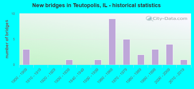
- New bridges - historical statistics
- 31900-1909
- 11930-1939
- 11950-1959
- 91960-1969
- 51970-1979
- 21980-1989
- 31990-1999
- 42000-2009
- 12010-2019

- Reconstructed bridges - Historical Statistics
- 11960-1969
- 11970-1979


- Bridge Condition - Deck
- 35.0%Very good
- 50.0%Good
- 15.0%Satisfactory

- Bridge Condition - Superstructure
- 38.1%Very good
- 38.1%Good
- 19.0%Satisfactory
- 4.8%Serious

- Bridge Condition - Substructure
- 52.4%Very good
- 23.8%Good
- 14.3%Satisfactory
- 9.5%Fair

- Bridge Condition - Channel
- 8.7%Very good
- 26.1%Good
- 52.2%Satisfactory
- 4.3%Fair
- 8.7%Poor

- Bridge Condition - Culverts
- 20.0%Very good
- 40.0%Good
- 20.0%Satisfactory
- 20.0%Fair
Find on map >> Show street view
Structure Number: 183165, Location: 4 MI WNW MONTROSE (Lat: 39.178658, Lng: -88.449792), Route carried "on" structure: County highway , Year Built: 1990, Status: Open, Structure Length: 2.37m (7.78ft), Average Daily Traffic: 250 (year 2021), Truck Traffic: 12%, Average Future Daily Traffic: 183 (year 2032), Design Load: HS 20, Features Intersected: SPRING POINT CREEK, Facility Carried by Structure: TR 219
Minimum Vertical Clearance: 30+ m (98+ ft), Kilometerpoint: 1.802, Lanes on structure: 2, Owner: Town or Township Highway Agency, Approaching Roadway Width: 5.5m (18.0ft), Skew: 1 degrees, Material/Design: Concrete continuous, Design/Construction: Slab, Number Of Spans In Main Unit: 3, Length of Maximum Span: 8.8m (28.9ft), Curb-To-Curb Width: 7.9m (25.9ft), Out-to-Out Width: 8.8m (28.9ft)
Condition: Deck: Very good, Superstructure: Very good, Substructure: Very good, Channel: Very good, Operating Rating: 44.4 metric tons, Method Used To Determine Operating Rating: Assigned rating based on Load Factor Design (LFD) reported by rating factor (RF) using MS18 loading, Inventory Rating: 32.4 metric tons, Method Used To Determine Inventory Rating: Assigned rating based on Load Factor Design (LFD) reported by rating factor (RF) using MS18 loading, Structural Evaluation: Equal to present desirable criteria, Deck Geometry: Somewhat better than minimum adequacy, Waterway Adequacy: Equal to present desirable criteria, Approach Roadway Alignment: Equal to present desirable criteria, Designated Inspection Frequency: Every 48 months, Inspection Date: March 2019, Deck Structure Type: Concrete Cast-file-Place, Wearing Surface/Protective System: Wearing Surface: Gravel
Find on map >> Show street view
Structure Number: 250051, Location: 5.0 MI E US-45 INT (Lat: 39.158989, Lng: -88.444519), Route carried "on" structure: County highway , Year Built: 1960, Status: Open, Structure Length: 6.83m (22.41ft), Average Daily Traffic: 325 (year 2018), Truck Traffic: 5%, Average Future Daily Traffic: 295 (year 2032), Design Load: HS 15, Features Intersected: FAI-70, Facility Carried by Structure: CH-11
Minimum Vertical Clearance: 4.90m (16.08ft), Kilometerpoint: 1.432, Lanes on structure: 2, Lanes under structure: 4, Owner: State Highway Agency, Approaching Roadway Width: 5.5m (18.0ft), Skew: 1 degrees, Material/Design: Steel continuous, Design/Construction: Stringer/Multi-beam, Number Of Spans In Main Unit: 4, Length of Maximum Span: 21.0m (68.9ft), Curb or Sidewalk Widths: Left: 0.6m (2.0ft), Right: 0.6m (2.0ft), Curb-To-Curb Width: 7.3m (24.0ft), Out-to-Out Width: 9.1m (29.9ft)
Condition: Deck: Good, Superstructure: Satisfactory, Substructure: Good, Operating Rating: 42.4 metric tons, Method Used To Determine Operating Rating: Allowable Stress (AS) rating reported by rating factor (RF) method using MS18 loading, Inventory Rating: 27.2 metric tons, Method Used To Determine Inventory Rating: Allowable Stress (AS) rating reported by rating factor (RF) method using MS18 loading, Structural Evaluation: Equal to present minimum criteria, Deck Geometry: Somewhat better than minimum adequacy, Underclear: High priority of corrective action, Approach Roadway Alignment: Equal to present desirable criteria, Designated Inspection Frequency: Every 24 months, Inspection Date: October 2020, Deck Structure Type: Concrete Cast-file-Place
Find on map >> Show street view
Structure Number: 250062, Location: 2.1 MI E US-45 INT (Lat: 39.150981, Lng: -88.495289), Route carried "on" structure: County highway , Year Built: 1960, Status: Open, Structure Length: 6.89m (22.60ft), Average Daily Traffic: 1,100 (year 2018), Truck Traffic: 8%, Average Future Daily Traffic: 589 (year 2032), Design Load: HS 15, Features Intersected: FAI-70, Facility Carried by Structure: TR-258
Minimum Vertical Clearance: 4.90m (16.08ft), Kilometerpoint: 2.237, Lanes on structure: 2, Lanes under structure: 4, Owner: State Highway Agency, Approaching Roadway Width: 6.1m (20.0ft), Skew: 1 degrees, Material/Design: Steel continuous, Design/Construction: Stringer/Multi-beam, Number Of Spans In Main Unit: 4, Length of Maximum Span: 21.0m (68.9ft), Curb or Sidewalk Widths: Left: 0.6m (2.0ft), Right: 0.6m (2.0ft), Curb-To-Curb Width: 7.3m (24.0ft), Out-to-Out Width: 9.1m (29.9ft)
Condition: Deck: Satisfactory, Superstructure: Satisfactory, Substructure: Good, Operating Rating: 57.7 metric tons, Method Used To Determine Operating Rating: Load Factor (LF) rating reported by rating factor (RF) method using MS18 loading, Inventory Rating: 30.8 metric tons, Method Used To Determine Inventory Rating: Load Factor (LF) rating reported by rating factor (RF) method using MS18 loading, Structural Evaluation: Equal to present minimum criteria, Deck Geometry: Meets minimum limits, Underclear: Meets minimum limits, Approach Roadway Alignment: Equal to present desirable criteria, Designated Inspection Frequency: Every 24 months, Inspection Date: December 2020, Deck Structure Type: Concrete Cast-file-Place
Find on map >> Show street view
Structure Number: 250064, Location: 3.6 MI E US-45 INT (Lat: 39.155389, Lng: -88.467400), Route carried "on" structure: County highway , Year Built: 1960, Status: Open, Structure Length: 6.83m (22.41ft), Average Daily Traffic: 500 (year 2018), Truck Traffic: 6%, Average Future Daily Traffic: 536 (year 2032), Design Load: HS 15, Features Intersected: FAI-70, Facility Carried by Structure: TR-288
Minimum Vertical Clearance: 4.93m (16.17ft), Kilometerpoint: 1.738, Lanes on structure: 2, Lanes under structure: 4, Owner: State Highway Agency, Approaching Roadway Width: 6.1m (20.0ft), Skew: 1 degrees, Material/Design: Steel continuous, Design/Construction: Stringer/Multi-beam, Number Of Spans In Main Unit: 4, Length of Maximum Span: 21.0m (68.9ft), Curb or Sidewalk Widths: Left: 0.6m (2.0ft), Right: 0.6m (2.0ft), Curb-To-Curb Width: 7.3m (24.0ft), Out-to-Out Width: 9.1m (29.9ft)
Condition: Deck: Satisfactory, Superstructure: Good, Substructure: Satisfactory, Operating Rating: 42.8 metric tons, Method Used To Determine Operating Rating: Load Factor (LF) rating reported by rating factor (RF) method using MS18 loading, Inventory Rating: 25.6 metric tons, Method Used To Determine Inventory Rating: Load Factor (LF) rating reported by rating factor (RF) method using MS18 loading, Structural Evaluation: Equal to present minimum criteria, Deck Geometry: Meets minimum limits, Underclear: High priority of corrective action, Approach Roadway Alignment: Equal to present desirable criteria, Length Of Structure Improvement: 6.83m (22.41ft), Designated Inspection Frequency: Every 24 months, Inspection Date: November 2020, Bridge Improvement Cost: $160,000, Roadway Improvement Cost: $16,000, Total Project Cost: $192,000, Deck Structure Type: Concrete Cast-file-Place
Find on map >> Show street view
Structure Number: 250082, Location: 2.5 MI NW DIETRICH (Lat: 39.089494, Lng: -88.442011), Route carried "on" structure: State highway 33, Year Built: 1977, Status: Open, Structure Length: 4.61m (15.12ft), Average Daily Traffic: 6,900 (year 2021), Truck Traffic: 14%, Average Future Daily Traffic: 6,426 (year 2032), Design Load: HS 20, Features Intersected: LITTLE SALT CREEK
Minimum Vertical Clearance: 30+ m (98+ ft), Kilometerpoint: 36.048, Lanes on structure: 2, Base Highway Network: Yes, Owner: State Highway Agency, Approaching Roadway Width: 13.4m (44.0ft), Material/Design: Prestressed concrete continuous, Design/Construction: Stringer/Multi-beam, Number Of Spans In Main Unit: 3, Length of Maximum Span: 15.2m (49.9ft), Curb-To-Curb Width: 13.0m (42.7ft), Out-to-Out Width: 14.0m (45.9ft)
Condition: Deck: Satisfactory, Superstructure: Satisfactory, Substructure: Good, Channel: Good, Operating Rating: 88.5 metric tons, Method Used To Determine Operating Rating: Load Factor (LF) rating reported by rating factor (RF) method using MS18 loading, Inventory Rating: 53.1 metric tons, Method Used To Determine Inventory Rating: Load Factor (LF) rating reported by rating factor (RF) method using MS18 loading, Structural Evaluation: Equal to present minimum criteria, Deck Geometry: Somewhat better than minimum adequacy, Waterway Adequacy: Better than present minimum criteria, Approach Roadway Alignment: Equal to present desirable criteria, Designated Inspection Frequency: Every 24 months, Inspection Date: January 2022, Deck Structure Type: Concrete Cast-file-Place, Wearing Surface/Protective System: Wearing Surface: Other
Find on map >> Show street view
Structure Number: 252006, Location: 2 MI E N. TRI-LEVEL (Lat: 39.153342, Lng: -88.480431), Route carried "on" structure: Interstate 70, Year Built: 1960, Status: Open, Structure Length: 1.37m (4.49ft), Average Daily Traffic: 25,800 (year 2021), Truck Traffic: 58%, Average Future Daily Traffic: 20,456 (year 2032), Design Load: HS 20, Features Intersected: SECOND SALT CK
Minimum Vertical Clearance: 30+ m (98+ ft), Kilometerpoint: 167.367, Lanes on structure: 4, Base Highway Network: Yes, Owner: State Highway Agency, Approaching Roadway Width: 23.2m (76.1ft), Skew: 13 degrees, Material/Design: Concrete, Design/Construction: Culvert, Number Of Spans In Main Unit: 3, Length of Maximum Span: 5.2m (17.1ft)
Condition: Channel: Satisfactory, Culverts: Satisfactory, Operating Rating: 84.9 metric tons, Method Used To Determine Operating Rating: Load Factor (LF) rating reported by rating factor (RF) method using MS18 loading, Inventory Rating: 50.9 metric tons, Method Used To Determine Inventory Rating: Load Factor (LF) rating reported by rating factor (RF) method using MS18 loading, Structural Evaluation: Equal to present minimum criteria, Waterway Adequacy: Equal to present desirable criteria, Approach Roadway Alignment: Equal to present desirable criteria, Designated Inspection Frequency: Every 24 months, Inspection Date: January 2022
Find on map >> Show street view
Structure Number: 252011, Location: 2.5 MI W MONTROSE (Lat: 39.145681, Lng: -88.426603), Route carried "on" structure: US 40, Year Built: 1958, Status: Open, Structure Length: 1.31m (4.30ft), Average Daily Traffic: 3,150 (year 2021), Truck Traffic: 13%, Average Future Daily Traffic: 3,213 (year 2032), Design Load: HS 20, Features Intersected: STREAM
Minimum Vertical Clearance: 30+ m (98+ ft), Kilometerpoint: 172.131, Lanes on structure: 2, Base Highway Network: Yes, Owner: State Highway Agency, Approaching Roadway Width: 7.9m (25.9ft), Skew: 4 degrees, Material/Design: Concrete, Design/Construction: Culvert, Number Of Spans In Main Unit: 3, Length of Maximum Span: 5.2m (17.1ft)
Condition: Channel: Satisfactory, Culverts: Good, Operating Rating: 36.3 metric tons, Method Used To Determine Operating Rating: Load Factor (LF) rating reported by rating factor (RF) method using MS18 loading, Inventory Rating: 21.7 metric tons, Method Used To Determine Inventory Rating: Load Factor (LF) rating reported by rating factor (RF) method using MS18 loading, Structural Evaluation: Somewhat better than minimum adequacy, Waterway Adequacy: Equal to present desirable criteria, Approach Roadway Alignment: Equal to present desirable criteria, Designated Inspection Frequency: Every 24 months, Inspection Date: January 2022
Find on map >> Show street view
Structure Number: 253006, Location: 4 MI S TEUTOPOLIS (Lat: 39.077275, Lng: -88.469294), Route carried "on" structure: County highway , Year Built: 1939, Status: Open, Structure Length: 4.39m (14.40ft), Average Daily Traffic: 1,050 (year 2018), Truck Traffic: 5%, Average Future Daily Traffic: 1,178 (year 2032), Features Intersected: LITTLE SALT CREEK, Facility Carried by Structure: FAS-709 (CH-19)
Minimum Vertical Clearance: 30+ m (98+ ft), Kilometerpoint: 6.164, Lanes on structure: 2, Owner: County Highway Agency, Approaching Roadway Width: 11.0m (36.1ft), Skew: 3 degrees, Material/Design: Steel continuous, Design/Construction: Stringer/Multi-beam, Number Of Spans In Main Unit: 3, Length of Maximum Span: 16.8m (55.1ft), Curb-To-Curb Width: 7.3m (24.0ft), Out-to-Out Width: 7.6m (24.9ft)
Condition: Deck: Good, Superstructure: Good, Substructure: Good, Channel: Satisfactory, Operating Rating: 40.8 metric tons, Method Used To Determine Operating Rating: Allowable Stress (AS) rating reported by rating factor (RF) method using MS18 loading, Inventory Rating: 26.9 metric tons, Method Used To Determine Inventory Rating: Allowable Stress (AS) rating reported by rating factor (RF) method using MS18 loading, Structural Evaluation: Equal to present minimum criteria, Deck Geometry: Meets minimum limits, Waterway Adequacy: Equal to present desirable criteria, Approach Roadway Alignment: Better than present minimum criteria, Designated Inspection Frequency: Every 24 months, Inspection Date: December 2020, Deck Structure Type: Concrete Cast-file-Place, Wearing Surface/Protective System: Wearing Surface: Gravel
Find on map >> Show street view
Structure Number: 253029, Location: 1 MI E TEUTOPOLIS (Lat: 39.142792, Lng: -88.444536), Route carried "on" structure: County highway , Year Built: 1967, Status: Open, Structure Length: 0.98m (3.22ft), Average Daily Traffic: 400 (year 2018), Truck Traffic: 7%, Average Future Daily Traffic: 348 (year 2032), Features Intersected: FIRST SALT CREEK, Facility Carried by Structure: CH-11 SCHNIEDER RD
Minimum Vertical Clearance: 30+ m (98+ ft), Kilometerpoint: 3.283, Lanes on structure: 1, Owner: County Highway Agency, Approaching Roadway Width: 6.7m (22.0ft), Material/Design: Concrete, Design/Construction: Channel Beam, Number Of Spans In Main Unit: 1, Length of Maximum Span: 9.1m (29.9ft), Curb-To-Curb Width: 5.2m (17.1ft), Out-to-Out Width: 5.8m (19.0ft)
Condition: Deck: Good, Superstructure: Satisfactory, Substructure: Good, Channel: Satisfactory, Operating Rating: 71.3 metric tons, Method Used To Determine Operating Rating: Load Factor (LF) rating reported by rating factor (RF) method using MS18 loading, Inventory Rating: 42.8 metric tons, Method Used To Determine Inventory Rating: Load Factor (LF) rating reported by rating factor (RF) method using MS18 loading, Structural Evaluation: Equal to present minimum criteria, Deck Geometry: High priority of replacement, Waterway Adequacy: Equal to present desirable criteria, Approach Roadway Alignment: Equal to present minimum criteria, Length Of Structure Improvement: 0.98m (3.22ft), Designated Inspection Frequency: Every 24 months, Inspection Date: November 2020, Bridge Improvement Cost: $73,000, Roadway Improvement Cost: $12,000, Total Project Cost: $85,000, Deck Structure Type: Concrete Precast Panels, Wearing Surface/Protective System: Wearing Surface: Gravel
Find on map >> Show street view
Structure Number: 253081, Location: 3 MI NW DIETERICH (Lat: 39.104000, Lng: -88.429078), Route carried "on" structure: County highway , Year Built: 1909, Year Reconstructed: 1973, Status: Open, Structure Length: 1.25m (4.10ft), Average Daily Traffic: 200 (year 2018), Truck Traffic: 2%, Average Future Daily Traffic: 134 (year 2032), Features Intersected: SALT CREEK, Facility Carried by Structure: TR-111
Minimum Vertical Clearance: 30+ m (98+ ft), Kilometerpoint: 2.768, Lanes on structure: 2, Owner: Town or Township Highway Agency, Approaching Roadway Width: 5.5m (18.0ft), Material/Design: Steel, Design/Construction: Stringer/Multi-beam, Number Of Spans In Main Unit: 3, Length of Maximum Span: 4.9m (16.1ft), Curb-To-Curb Width: 7.3m (24.0ft), Out-to-Out Width: 7.7m (25.3ft)
Condition: Deck: Good, Superstructure: Good, Substructure: Fair, Channel: Poor, Operating Rating: 53.8 metric tons, Method Used To Determine Operating Rating: Field evaluation and documented engineering judgment, Inventory Rating: 32.4 metric tons, Method Used To Determine Inventory Rating: Field evaluation and documented engineering judgment, Structural Evaluation: Somewhat better than minimum adequacy, Deck Geometry: Somewhat better than minimum adequacy, Waterway Adequacy: Equal to present minimum criteria, Approach Roadway Alignment: Equal to present minimum criteria, Designated Inspection Frequency: Every 24 months, Inspection Date: November 2020, Deck Structure Type: Concrete Cast-file-Place, Wearing Surface/Protective System: Wearing Surface: Gravel
Find on map >> Show street view
Structure Number: 253123, Location: 3 MI SE EFFINGHAM (Lat: 39.096278, Lng: -88.486342), Route carried "on" structure: County highway , Year Built: 1909, Year Reconstructed: 1975, Status: Open, Structure Length: 1.04m (3.41ft), Average Daily Traffic: 275 (year 2018), Truck Traffic: 4%, Average Future Daily Traffic: 268 (year 2032), Features Intersected: BRUSH CREEK, Facility Carried by Structure: TR-268
Minimum Vertical Clearance: 30+ m (98+ ft), Kilometerpoint: 2.494, Lanes on structure: 1, Owner: Town or Township Highway Agency, Approaching Roadway Width: 6.1m (20.0ft), Material/Design: Concrete, Design/Construction: Channel Beam, Number Of Spans In Main Unit: 1, Length of Maximum Span: 9.1m (29.9ft), Curb-To-Curb Width: 5.5m (18.0ft), Out-to-Out Width: 5.7m (18.7ft)
Condition: Deck: Good, Superstructure: Good, Substructure: Fair, Channel: Satisfactory, Operating Rating: 41.5 metric tons, Method Used To Determine Operating Rating: Load Factor (LF) rating reported by rating factor (RF) method using MS18 loading, Inventory Rating: 24.9 metric tons, Method Used To Determine Inventory Rating: Load Factor (LF) rating reported by rating factor (RF) method using MS18 loading, Structural Evaluation: Somewhat better than minimum adequacy, Deck Geometry: High priority of corrective action, Waterway Adequacy: Equal to present minimum criteria, Approach Roadway Alignment: Equal to present minimum criteria, Length Of Structure Improvement: 1.65m (5.41ft), Designated Inspection Frequency: Every 24 months, Inspection Date: December 2020, Bridge Improvement Cost: $67,000, Roadway Improvement Cost: $7,000, Total Project Cost: $101,000, Deck Structure Type: Concrete Precast Panels, Wearing Surface/Protective System: Wearing Surface: Gravel
Find on map >> Show street view
Structure Number: 25313, Location: NE CORNER TEUTOPOLIS (Lat: 39.140703, Lng: -88.467272), Route carried "on" structure: County highway , Year Built: 1969, Status: Open, Structure Length: 1.62m (5.31ft), Average Daily Traffic: 600 (year 2018), Truck Traffic: 5%, Average Future Daily Traffic: 803 (year 2032), Features Intersected: FIRST SALT CREEK, Facility Carried by Structure: TR-288
Minimum Vertical Clearance: 30+ m (98+ ft), Kilometerpoint: 3.412, Lanes on structure: 2, Owner: Town or Township Highway Agency, Approaching Roadway Width: 6.7m (22.0ft), Material/Design: Concrete, Design/Construction: Tee Beam, Number Of Spans In Main Unit: 2, Length of Maximum Span: 8.2m (26.9ft), Curb-To-Curb Width: 7.4m (24.3ft), Out-to-Out Width: 8.0m (26.2ft)
Condition: Deck: Good, Superstructure: Good, Substructure: Satisfactory, Channel: Fair, Operating Rating: 40.5 metric tons, Method Used To Determine Operating Rating: Field evaluation and documented engineering judgment, Inventory Rating: 24.3 metric tons, Method Used To Determine Inventory Rating: Field evaluation and documented engineering judgment, Structural Evaluation: Equal to present minimum criteria, Deck Geometry: Meets minimum limits, Waterway Adequacy: Better than present minimum criteria, Approach Roadway Alignment: Equal to present minimum criteria, Designated Inspection Frequency: Every 24 months, Inspection Date: December 2020, Deck Structure Type: Concrete Precast Panels, Wearing Surface/Protective System: Wearing Surface: Gravel
Find on map >> Show street view
Structure Number: 253138, Location: 3 MI NW DIETERICH (Lat: 39.095911, Lng: -88.436011), Route carried "on" structure: County highway , Year Built: 1909, Status: Posted for load, Structure Length: 1.52m (4.99ft), Average Daily Traffic: 25 (year 2018), Truck Traffic: 8%, Average Future Daily Traffic: 27 (year 2032), Features Intersected: LITTLE SALT CREEK, Facility Carried by Structure: TR-304
Minimum Vertical Clearance: 30+ m (98+ ft), Kilometerpoint: 2.494, Lanes on structure: 1, Owner: Town or Township Highway Agency, Approaching Roadway Width: 4.9m (16.1ft), Material/Design: Steel, Design/Construction: Truss - Thru, Number Of Spans In Main Unit: 1, Length of Maximum Span: 15.2m (49.9ft), Curb-To-Curb Width: 4.1m (13.5ft), Out-to-Out Width: 4.3m (14.1ft)
Condition: Deck: Good, Superstructure: Serious, Substructure: Satisfactory, Channel: Poor, Operating Rating: 5.8 metric tons, Method Used To Determine Operating Rating: Load Factor (LF) rating reported by rating factor (RF) method using MS18 loading, Inventory Rating: 3.6 metric tons, Method Used To Determine Inventory Rating: Load Factor (LF) rating reported by rating factor (RF) method using MS18 loading, Structural Evaluation: High priority of replacement, Deck Geometry: Somewhat better than minimum adequacy, Waterway Adequacy: High priority of replacement, Approach Roadway Alignment: High priority of corrective action, Bridge Posting: Required (Relationship of Operating Rating to Maximum Legal Load: > 39.9% below), Length Of Structure Improvement: 2.29m (7.51ft), Designated Inspection Frequency: Every 24 months, Critical Feature Inspection Frequency: Every 12 months, Other Special Inspection Frequency: Every 6 months, Inspection Date: January 2021, Critical Feature Inspection Date: August 2021, Other Special Inspection Date: August 2021, Bridge Improvement Cost: $74,000, Roadway Improvement Cost: $7,000, Total Project Cost: $112,000, Deck Structure Type: Concrete Cast-file-Place
Find on map >> Show street view
Structure Number: 253152, Location: 2.5 MI SE TEUTOPOLIS (Lat: 39.118467, Lng: -88.425558), Route carried "on" structure: County highway , Year Built: 1972, Status: Open, Structure Length: 0.98m (3.22ft), Average Daily Traffic: 450 (year 2018), Truck Traffic: 2%, Average Future Daily Traffic: 348 (year 2032), Features Intersected: LITTLE SALT CREEK, Facility Carried by Structure: TR-87A
Minimum Vertical Clearance: 30+ m (98+ ft), Kilometerpoint: 4.828, Lanes on structure: 2, Owner: Town or Township Highway Agency, Approaching Roadway Width: 7.3m (24.0ft), Skew: 5 degrees, Material/Design: Concrete continuous, Design/Construction: Culvert, Number Of Spans In Main Unit: 2, Length of Maximum Span: 4.9m (16.1ft)
Condition: Channel: Satisfactory, Culverts: Good, Operating Rating: 40.5 metric tons, Method Used To Determine Operating Rating: Field evaluation and documented engineering judgment, Inventory Rating: 24.3 metric tons, Method Used To Determine Inventory Rating: Field evaluation and documented engineering judgment, Structural Evaluation: Equal to present minimum criteria, Waterway Adequacy: Better than present minimum criteria, Approach Roadway Alignment: Equal to present desirable criteria, Designated Inspection Frequency: Every 24 months, Inspection Date: November 2020, Wearing Surface/Protective System: Wearing Surface: Gravel
Find on map >> Show street view
Structure Number: 253191, Location: 2.5 MI N TEUTOPOLIS (Lat: 39.166425, Lng: -88.467208), Route carried "on" structure: County highway , Year Built: 1994, Status: Open, Structure Length: 1.89m (6.20ft), Average Daily Traffic: 350 (year 2018), Truck Traffic: 7%, Average Future Daily Traffic: 348 (year 2032), Design Load: HS 20, Features Intersected: SECOND SALT CREEK, Facility Carried by Structure: TR-288
Minimum Vertical Clearance: 30+ m (98+ ft), Kilometerpoint: 0.563, Lanes on structure: 2, Owner: Town or Township Highway Agency, Approaching Roadway Width: 6.1m (20.0ft), Skew: 3 degrees, Material/Design: Prestressed concrete, Design/Construction: Box Beam or Girders - Multiple, Number Of Spans In Main Unit: 1, Length of Maximum Span: 17.9m (58.7ft), Curb-To-Curb Width: 7.3m (24.0ft), Out-to-Out Width: 7.3m (24.0ft)
Condition: Deck: Very good, Superstructure: Very good, Substructure: Very good, Channel: Satisfactory, Operating Rating: 64.5 metric tons, Method Used To Determine Operating Rating: Load Factor (LF) rating reported by rating factor (RF) method using MS18 loading, Inventory Rating: 38.6 metric tons, Method Used To Determine Inventory Rating: Load Factor (LF) rating reported by rating factor (RF) method using MS18 loading, Structural Evaluation: Equal to present desirable criteria, Deck Geometry: Somewhat better than minimum adequacy, Waterway Adequacy: Equal to present desirable criteria, Approach Roadway Alignment: Equal to present desirable criteria, Designated Inspection Frequency: Every 48 months, Inspection Date: September 2019, Deck Structure Type: Concrete Precast Panels, Wearing Surface/Protective System: Wearing Surface: Gravel
Find on map >> Show street view
Structure Number: 253195, Location: 4 MI NW DIETERICH (Lat: 39.081394, Lng: -88.455681), Route carried "on" structure: County highway , Year Built: 2002, Status: Open, Structure Length: 1.35m (4.43ft), Average Daily Traffic: 225 (year 2018), Truck Traffic: 3%, Average Future Daily Traffic: 161 (year 2032), Design Load: HS 20, Features Intersected: SALT CREEK, Facility Carried by Structure: TR-294
Minimum Vertical Clearance: 30+ m (98+ ft), Kilometerpoint: 4.104, Lanes on structure: 1, Owner: Town or Township Highway Agency, Approaching Roadway Width: 6.1m (20.0ft), Material/Design: Concrete, Design/Construction: Frame, Number Of Spans In Main Unit: 1, Length of Maximum Span: 12.3m (40.4ft), Curb-To-Curb Width: 4.3m (14.1ft), Out-to-Out Width: 4.3m (14.1ft)
Condition: Superstructure: Very good, Substructure: Very good, Channel: Good, Operating Rating: 53.8 metric tons, Method Used To Determine Operating Rating: Field evaluation and documented engineering judgment, Inventory Rating: 32.4 metric tons, Method Used To Determine Inventory Rating: Field evaluation and documented engineering judgment, Structural Evaluation: Equal to present desirable criteria, Deck Geometry: High priority of replacement, Waterway Adequacy: Equal to present desirable criteria, Approach Roadway Alignment: Better than present minimum criteria, Designated Inspection Frequency: Every 48 months, Inspection Date: September 2019, Wearing Surface/Protective System: Wearing Surface: Gravel
Find on map >> Show street view
Structure Number: 253198, Location: 0.5 MI W TEUTOPOLIS (Lat: 39.139456, Lng: -88.492436), Route carried "on" structure: County highway , Year Built: 1997, Status: Open, Structure Length: 2.33m (7.64ft), Average Daily Traffic: 250 (year 2018), Truck Traffic: 2%, Average Future Daily Traffic: 321 (year 2032), Design Load: HS 20, Features Intersected: SALT CREEK, Facility Carried by Structure: TR-256
Minimum Vertical Clearance: 30+ m (98+ ft), Kilometerpoint: 1.384, Lanes on structure: 2, Owner: Town or Township Highway Agency, Approaching Roadway Width: 8.5m (27.9ft), Material/Design: Prestressed concrete, Design/Construction: Box Beam or Girders - Multiple, Number Of Spans In Main Unit: 3, Length of Maximum Span: 7.6m (24.9ft), Curb-To-Curb Width: 8.5m (27.9ft), Out-to-Out Width: 8.5m (27.9ft)
Condition: Deck: Good, Superstructure: Good, Substructure: Very good, Channel: Good, Operating Rating: 59.0 metric tons, Method Used To Determine Operating Rating: Load Factor (LF) rating reported by rating factor (RF) method using MS18 loading, Inventory Rating: 35.3 metric tons, Method Used To Determine Inventory Rating: Load Factor (LF) rating reported by rating factor (RF) method using MS18 loading, Structural Evaluation: Better than present minimum criteria, Deck Geometry: Equal to present minimum criteria, Waterway Adequacy: Equal to present desirable criteria, Approach Roadway Alignment: Equal to present desirable criteria, Designated Inspection Frequency: Every 48 months, Inspection Date: December 2020, Deck Structure Type: Concrete Precast Panels
Find on map >> Show street view
Structure Number: 2532, Location: N C L TEUTOPOLIS (Lat: 39.140314, Lng: -88.481461), Route carried "on" structure: County highway , Year Built: 1976, Status: Open, Structure Length: 1.68m (5.51ft), Average Daily Traffic: 2,350 (year 2018), Truck Traffic: 5%, Average Future Daily Traffic: 2,624 (year 2032), Design Load: HS 20, Features Intersected: FIRST SALT CREEK, Facility Carried by Structure: FAS-1725
Minimum Vertical Clearance: 30+ m (98+ ft), Kilometerpoint: 2.462, Lanes on structure: 2, Owner: County Highway Agency, Approaching Roadway Width: 9.1m (29.9ft), Material/Design: Prestressed concrete, Design/Construction: Box Beam or Girders - Multiple, Number Of Spans In Main Unit: 1, Length of Maximum Span: 16.2m (53.1ft), Curb-To-Curb Width: 8.7m (28.5ft), Out-to-Out Width: 9.8m (32.2ft)
Condition: Deck: Good, Superstructure: Good, Substructure: Very good, Channel: Satisfactory, Operating Rating: 44.4 metric tons, Method Used To Determine Operating Rating: Load Factor (LF) rating reported by rating factor (RF) method using MS18 loading, Inventory Rating: 32.4 metric tons, Method Used To Determine Inventory Rating: Load Factor (LF) rating reported by rating factor (RF) method using MS18 loading, Structural Evaluation: Better than present minimum criteria, Deck Geometry: Meets minimum limits, Waterway Adequacy: Equal to present desirable criteria, Approach Roadway Alignment: Equal to present desirable criteria, Designated Inspection Frequency: Every 48 months, Inspection Date: January 2021, Deck Structure Type: Concrete Precast Panels, Wearing Surface/Protective System: Wearing Surface: Bituminous
Find on map >> Show street view
Structure Number: 253201, Location: 0.5 N TEUTOPOLIS (Lat: 39.146750, Lng: -88.485931), Route carried "on" structure: County highway , Year Built: 1976, Status: Open, Structure Length: 1.46m (4.79ft), Average Daily Traffic: 2,350 (year 2018), Truck Traffic: 5%, Average Future Daily Traffic: 2,303 (year 2032), Design Load: HS 20, Features Intersected: SECOND SALT CREEK, Facility Carried by Structure: FAS-1725
Minimum Vertical Clearance: 30+ m (98+ ft), Kilometerpoint: 1.641, Lanes on structure: 2, Owner: County Highway Agency, Approaching Roadway Width: 10.4m (34.1ft), Material/Design: Prestressed concrete, Design/Construction: Box Beam or Girders - Multiple, Number Of Spans In Main Unit: 1, Length of Maximum Span: 14.3m (46.9ft), Curb-To-Curb Width: 8.7m (28.5ft), Out-to-Out Width: 9.8m (32.2ft)
Condition: Deck: Good, Superstructure: Good, Substructure: Very good, Channel: Satisfactory, Operating Rating: 44.4 metric tons, Method Used To Determine Operating Rating: Load Factor (LF) rating reported by rating factor (RF) method using MS18 loading, Inventory Rating: 32.4 metric tons, Method Used To Determine Inventory Rating: Load Factor (LF) rating reported by rating factor (RF) method using MS18 loading, Structural Evaluation: Better than present minimum criteria, Deck Geometry: Meets minimum limits, Waterway Adequacy: Equal to present desirable criteria, Approach Roadway Alignment: Equal to present desirable criteria, Designated Inspection Frequency: Every 48 months, Inspection Date: January 2021, Deck Structure Type: Concrete Precast Panels, Wearing Surface/Protective System: Wearing Surface: Bituminous
Find on map >> Show street view
Structure Number: 253211, Location: 1.5 MI E TEUTOPOLIS (Lat: 39.147456, Lng: -88.444725), Route carried "on" structure: County highway , Year Built: 1987, Status: Open, Structure Length: 1.89m (6.20ft), Average Daily Traffic: 400 (year 2018), Truck Traffic: 7%, Average Future Daily Traffic: 348 (year 2032), Design Load: HS 20, Features Intersected: BR FIRST SALT CREEK, Facility Carried by Structure: CH-11 SCHNIEDER RD
Minimum Vertical Clearance: 30+ m (98+ ft), Kilometerpoint: 2.768, Lanes on structure: 2, Owner: County Highway Agency, Approaching Roadway Width: 6.7m (22.0ft), Skew: 3 degrees, Material/Design: Prestressed concrete, Design/Construction: Box Beam or Girders - Multiple, Number Of Spans In Main Unit: 1, Length of Maximum Span: 17.7m (58.1ft), Curb-To-Curb Width: 8.5m (27.9ft), Out-to-Out Width: 8.6m (28.2ft)
Condition: Deck: Very good, Superstructure: Very good, Substructure: Very good, Channel: Good, Operating Rating: 61.6 metric tons, Method Used To Determine Operating Rating: Load Factor (LF) rating reported by rating factor (RF) method using MS18 loading, Inventory Rating: 36.9 metric tons, Method Used To Determine Inventory Rating: Load Factor (LF) rating reported by rating factor (RF) method using MS18 loading, Structural Evaluation: Equal to present desirable criteria, Deck Geometry: Equal to present minimum criteria, Waterway Adequacy: Equal to present desirable criteria, Approach Roadway Alignment: Equal to present desirable criteria, Designated Inspection Frequency: Every 48 months, Inspection Date: November 2018, Deck Structure Type: Concrete Precast Panels, Wearing Surface/Protective System: Wearing Surface: Gravel
Find on map >> Show street view
Structure Number: 253306, Location: 1 MI W TEUTOPOLIS (Lat: 39.137408, Lng: -88.504708), Route carried "on" structure: County highway , Year Built: 2002, Status: Open, Structure Length: 4.15m (13.62ft), Average Daily Traffic: 375 (year 2018), Truck Traffic: 3%, Average Future Daily Traffic: 536 (year 2032), Design Load: HS 20, Features Intersected: SALT CREEK, Facility Carried by Structure: TR 242
Minimum Vertical Clearance: 30+ m (98+ ft), Kilometerpoint: 1.191, Lanes on structure: 2, Owner: Town or Township Highway Agency, Approaching Roadway Width: 5.5m (18.0ft), Material/Design: Prestressed concrete, Design/Construction: Box Beam or Girders - Multiple, Number Of Spans In Main Unit: 3, Length of Maximum Span: 13.7m (44.9ft), Curb-To-Curb Width: 7.3m (24.0ft), Out-to-Out Width: 7.3m (24.0ft)
Condition: Deck: Very good, Superstructure: Very good, Substructure: Very good, Channel: Good, Operating Rating: 44.1 metric tons, Method Used To Determine Operating Rating: Assigned rating based on Load Factor Design (LFD) reported by rating factor (RF) using MS18 loading, Inventory Rating: 32.4 metric tons, Method Used To Determine Inventory Rating: Assigned rating based on Load Factor Design (LFD) reported by rating factor (RF) using MS18 loading, Structural Evaluation: Equal to present desirable criteria, Deck Geometry: Somewhat better than minimum adequacy, Waterway Adequacy: Equal to present desirable criteria, Approach Roadway Alignment: Better than present minimum criteria, Designated Inspection Frequency: Every 48 months, Inspection Date: September 2019, Deck Structure Type: Concrete Precast Panels
Find on map >> Show street view
Structure Number: 253315, Location: 2 MI N TEUTOPOLIS (Lat: 39.162061, Lng: -88.471172), Route carried "on" structure: County highway , Year Built: 2006, Status: Open, Structure Length: 1.87m (6.14ft), Average Daily Traffic: 100 (year 2018), Average Future Daily Traffic: 187 (year 2032), Design Load: HS 20, Features Intersected: SECOND SALT CREEK, Facility Carried by Structure: TR 41
Minimum Vertical Clearance: 30+ m (98+ ft), Kilometerpoint: 2.076, Lanes on structure: 2, Owner: Town or Township Highway Agency, Approaching Roadway Width: 5.5m (18.0ft), Skew: 1 degrees, Material/Design: Prestressed concrete, Design/Construction: Box Beam or Girders - Multiple, Number Of Spans In Main Unit: 1, Length of Maximum Span: 18.0m (59.1ft), Curb-To-Curb Width: 7.3m (24.0ft), Out-to-Out Width: 7.3m (24.0ft)
Condition: Deck: Very good, Superstructure: Very good, Substructure: Very good, Channel: Very good, Operating Rating: 76.5 metric tons, Method Used To Determine Operating Rating: Load Factor (LF) rating reported by rating factor (RF) method using MS18 loading, Inventory Rating: 45.7 metric tons, Method Used To Determine Inventory Rating: Load Factor (LF) rating reported by rating factor (RF) method using MS18 loading, Structural Evaluation: Equal to present desirable criteria, Deck Geometry: Equal to present minimum criteria, Waterway Adequacy: Equal to present desirable criteria, Approach Roadway Alignment: Better than present minimum criteria, Designated Inspection Frequency: Every 48 months, Inspection Date: December 2020, Deck Structure Type: Concrete Precast Panels
Find on map >> Show street view
Structure Number: 253317, Location: 1 MI NW TEUTOPOLIS (Lat: 39.147814, Lng: -88.500039), Route carried "on" structure: County highway , Year Built: 2008, Status: Open, Structure Length: 0.67m (2.20ft), Average Daily Traffic: 250 (year 2018), Truck Traffic: 2%, Average Future Daily Traffic: 321 (year 2032), Design Load: HS 20, Features Intersected: CREEK, Facility Carried by Structure: TR 256
Minimum Vertical Clearance: 30+ m (98+ ft), Kilometerpoint: 0.016, Lanes on structure: 2, Owner: Town or Township Highway Agency, Approaching Roadway Width: 5.5m (18.0ft), Material/Design: Aluminum, Iron, Design/Construction: Frame, Number Of Spans In Main Unit: 1, Length of Maximum Span: 6.7m (22.0ft), Curb-To-Curb Width: 5.5m (18.0ft), Out-to-Out Width: 5.5m (18.0ft)
Condition: Deck: Very good, Superstructure: Very good, Substructure: Very good, Channel: Satisfactory, Operating Rating: 64.2 metric tons, Method Used To Determine Operating Rating: Load Factor (LF) rating reported by rating factor (RF) method using MS18 loading, Inventory Rating: 38.6 metric tons, Method Used To Determine Inventory Rating: Load Factor (LF) rating reported by rating factor (RF) method using MS18 loading, Structural Evaluation: Equal to present desirable criteria, Deck Geometry: High priority of corrective action, Waterway Adequacy: Equal to present desirable criteria, Approach Roadway Alignment: Equal to present desirable criteria, Designated Inspection Frequency: Every 24 months, Inspection Date: December 2020
Find on map >> Show street view
Structure Number: 253329, Location: 2.0 Mi. N of Ttown (Lat: 39.169472, Lng: -88.467186), Route carried "on" structure: County highway , Year Built: 2016, Status: Open, Structure Length: 0.75m (2.46ft), Average Daily Traffic: 350 (year 2018), Truck Traffic: 7%, Average Future Daily Traffic: 250 (year 2017), Design Load: HS 25 or greater, Features Intersected: Trib Salt Creek Tr, Facility Carried by Structure: TR 288
Minimum Vertical Clearance: 30+ m (98+ ft), Kilometerpoint: 0.225, Lanes on structure: 2, Owner: Town or Township Highway Agency, Approaching Roadway Width: 5.5m (18.0ft), Material/Design: Aluminum, Iron, Design/Construction: Arch - Thru, Number Of Spans In Main Unit: 1, Length of Maximum Span: 0.0m, Curb-To-Curb Width: 5.5m (18.0ft), Out-to-Out Width: 11.7m (38.4ft)
Condition: Deck: Very good, Superstructure: Very good, Substructure: Very good, Channel: Good, Operating Rating: 53.8 metric tons, Method Used To Determine Operating Rating: Load Factor (LF) rating reported by rating factor (RF) method using MS18 loading, Inventory Rating: 32.4 metric tons, Method Used To Determine Inventory Rating: Load Factor (LF) rating reported by rating factor (RF) method using MS18 loading, Structural Evaluation: Equal to present desirable criteria, Deck Geometry: High priority of corrective action, Waterway Adequacy: Superior to present desirable criteria, Approach Roadway Alignment: Equal to present desirable criteria, Designated Inspection Frequency: Every 24 months, Inspection Date: November 2020, Deck Structure Type: Aluminum, Wearing Surface/Protective System: Wearing Surface: Gravel
Find on map >> Show street view
Structure Number: 255009, Location: 3 MI N TEUTOPOLIS (Lat: 39.171464, Lng: -88.474853), Route carried "on" structure: County highway , Year Built: 1977, Status: Open, Structure Length: 0.73m (2.40ft), Average Daily Traffic: 300 (year 2018), Truck Traffic: 2%, Average Future Daily Traffic: 295 (year 2032), Design Load: HS 20, Features Intersected: BRANCH SALT CREEK, Facility Carried by Structure: TR-31
Minimum Vertical Clearance: 30+ m (98+ ft), Kilometerpoint: 5.793, Lanes on structure: 2, Owner: Town or Township Highway Agency, Approaching Roadway Width: 6.7m (22.0ft), Skew: 3 degrees, Material/Design: Concrete, Design/Construction: Culvert, Number Of Spans In Main Unit: 2, Length of Maximum Span: 3.7m (12.1ft), Curb-To-Curb Width: 7.4m (24.3ft), Out-to-Out Width: 7.9m (25.9ft)
Condition: Channel: Satisfactory, Culverts: Fair, Operating Rating: 48.3 metric tons, Method Used To Determine Operating Rating: Load Factor (LF) rating reported by rating factor (RF) method using MS18 loading, Inventory Rating: 28.8 metric tons, Method Used To Determine Inventory Rating: Load Factor (LF) rating reported by rating factor (RF) method using MS18 loading, Structural Evaluation: Somewhat better than minimum adequacy, Deck Geometry: Somewhat better than minimum adequacy, Waterway Adequacy: Equal to present minimum criteria, Approach Roadway Alignment: Equal to present desirable criteria, Designated Inspection Frequency: Every 24 months, Inspection Date: December 2020, Wearing Surface/Protective System: Wearing Surface: Gravel
Find on map >> Show street view
Structure Number: 255018, Location: 1.5 MI N T-TOWN (Lat: 39.154808, Lng: -88.478614), Route carried "on" structure: County highway , Year Built: 1983, Status: Open, Structure Length: 1.34m (4.40ft), Average Daily Traffic: 100 (year 2018), Truck Traffic: 3%, Average Future Daily Traffic: 80 (year 2032), Design Load: HS 20, Features Intersected: SECOND SALT CREEK, Facility Carried by Structure: TR-47A
Minimum Vertical Clearance: 30+ m (98+ ft), Kilometerpoint: 0.756, Lanes on structure: 2, Owner: Town or Township Highway Agency, Approaching Roadway Width: 6.1m (20.0ft), Skew: 2 degrees, Material/Design: Concrete, Design/Construction: Culvert, Number Of Spans In Main Unit: 3, Length of Maximum Span: 5.0m (16.4ft), Curb-To-Curb Width: 7.3m (24.0ft), Out-to-Out Width: 8.0m (26.2ft)
Condition: Channel: Satisfactory, Culverts: Very good, Operating Rating: 44.4 metric tons, Method Used To Determine Operating Rating: Assigned rating based on Load Factor Design (LFD) reported by rating factor (RF) using MS18 loading, Inventory Rating: 32.4 metric tons, Method Used To Determine Inventory Rating: Assigned rating based on Load Factor Design (LFD) reported by rating factor (RF) using MS18 loading, Structural Evaluation: Equal to present desirable criteria, Deck Geometry: Equal to present minimum criteria, Waterway Adequacy: Equal to present desirable criteria, Approach Roadway Alignment: Better than present minimum criteria, Designated Inspection Frequency: Every 48 months, Inspection Date: December 2018, Deck Structure Type: Concrete Cast-file-Place, Wearing Surface/Protective System: Wearing Surface: Gravel
Find on map >> Show street view
Structure Number: 250051, Location: 5.0 MI E US-45 INT (Lat: 39.158989, Lng: -88.444519), Route carried "under" structure: Interstate 70, Year Built: 1960, Structure Length: 0. m, Average Daily Traffic: 25,800 (year 2021), Truck Traffic: 58%, Features Intersected: FAI-70, Facility Carried by Structure: CH-11
Minimum Vertical Clearance: 4.90m (16.08ft), Kilometerpoint: 170.538, Lanes on structure: 2, Lanes under structure: 4, Material/Design: Steel continuous, Design/Construction: Stringer/Multi-beam, Length of Maximum Span: 21.0m (68.9ft)
Find on map >> Show street view
Structure Number: 250062, Location: 2.1 MI E US-45 INT (Lat: 39.150981, Lng: -88.495289), Route carried "under" structure: Interstate 70, Year Built: 1960, Structure Length: 0. m, Average Daily Traffic: 25,800 (year 2021), Truck Traffic: 58%, Features Intersected: FAI-70, Facility Carried by Structure: TR-258
Minimum Vertical Clearance: 5.28m (17.32ft), Kilometerpoint: 166.064, Lanes on structure: 2, Lanes under structure: 4, Material/Design: Steel continuous, Design/Construction: Stringer/Multi-beam, Length of Maximum Span: 21.0m (68.9ft)
Find on map >> Show street view
Structure Number: 250064, Location: 3.6 MI E US-45 INT (Lat: 39.155389, Lng: -88.467400), Route carried "under" structure: Interstate 70, Year Built: 1960, Structure Length: 0. m, Average Daily Traffic: 25,800 (year 2021), Truck Traffic: 58%, Features Intersected: FAI-70, Facility Carried by Structure: TR-288
Minimum Vertical Clearance: 4.88m (16.01ft), Kilometerpoint: 168.510, Lanes on structure: 2, Lanes under structure: 4, Material/Design: Steel continuous, Design/Construction: Stringer/Multi-beam, Length of Maximum Span: 21.0m (68.9ft)