Bridge Statistics for Tekonsha, Michigan (MI)
Condition, Traffic, Stress, Structural Evaluation, Project Costs
- National Bridge Inventory (NBI) Statistics
- 13Number of bridges
- 92ft / 27.8mTotal length
- $30,000Total costs
- 111,051Total average daily traffic
- 34,743Total average daily truck traffic
- National Bridge Inventory (NBI) Registered Bridges for Tekonsha
- No street view available for this location
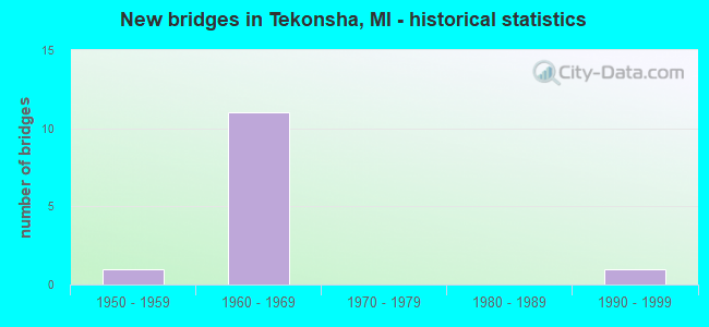
- New bridges - historical statistics
- 11950-1959
- 111960-1969
- 11990-1999


- Bridge Condition - Deck
- 14.3%Good
- 71.4%Satisfactory
- 14.3%Fair

- Bridge Condition - Superstructure
- 14.3%Good
- 28.6%Satisfactory
- 42.9%Fair
- 14.3%Poor

- Bridge Condition - Substructure
- 14.3%Good
- 85.7%Satisfactory
Find on map >> Show street view
Structure Number: 1099, Location: 8.5 MI N OF US-12 (Lat: 42.058536, Lng: -84.978028), Route carried "on" structure: County highway , Year Built: 1967, Status: Open, Structure Length: 6.58m (21.59ft), Average Daily Traffic: 400 (year 1988), Average Future Daily Traffic: 460 (year 2008), Design Load: H 15, Features Intersected: I-69, Facility Carried by Structure: HERRICKSVILLE ROAD
Minimum Vertical Clearance: 30.48m (100.00ft), Kilometerpoint: 1.918, Lanes on structure: 2, Lanes under structure: 4, Owner: State Highway Agency, Approaching Roadway Width: 6.7m (22.0ft), Material/Design: Steel continuous, Design/Construction: Stringer/Multi-beam, Number Of Spans In Main Unit: 2, Length of Maximum Span: 32.9m (107.9ft), Curb or Sidewalk Widths: Left: 0.1m (0.3ft), Right: 0.1m (0.3ft), Curb-To-Curb Width: 8.0m (26.2ft), Out-to-Out Width: 9.8m (32.2ft)
Condition: Deck: Satisfactory, Superstructure: Fair, Substructure: Satisfactory, Operating Rating: 55.4 metric tons, Method Used To Determine Operating Rating: Load Factor (LF) rating reported by rating factor (RF) method using MS18 loading, Inventory Rating: 33.0 metric tons, Method Used To Determine Inventory Rating: Load Factor (LF) rating reported by rating factor (RF) method using MS18 loading, Structural Evaluation: Somewhat better than minimum adequacy, Deck Geometry: Somewhat better than minimum adequacy, Underclear: Meets minimum limits, Approach Roadway Alignment: Better than present minimum criteria, Designated Inspection Frequency: Every 24 months, Inspection Date: May 2021, Deck Structure Type: Concrete Cast-file-Place, Wearing Surface/Protective System: Wearing Surface: Other
Find on map >> Show street view
Structure Number: 1225, Location: @ M-60 (Lat: 42.105853, Lng: -84.996342), Route carried "on" structure: Interstate 69, Year Built: 1968, Status: Open, Structure Length: 3.38m (11.09ft), Average Daily Traffic: 11,162 (year 2007), Truck Traffic: 33%, Average Future Daily Traffic: 14,169 (year 2018), Design Load: HS 20+Mod, Features Intersected: M-60
Minimum Vertical Clearance: 30.48m (100.00ft), Kilometerpoint: 4.183, Lanes on structure: 2, Lanes under structure: 2, Base Highway Network: Yes (Inventory Route: 129, Subroute: 1), Owner: State Highway Agency, Approaching Roadway Width: 12.2m (40.0ft), Material/Design: Steel, Design/Construction: Stringer/Multi-beam, Number Of Spans In Main Unit: 3, Length of Maximum Span: 13.7m (44.9ft), Curb-To-Curb Width: 11.8m (38.7ft), Out-to-Out Width: 12.8m (42.0ft)
Condition: Deck: Satisfactory, Superstructure: Fair, Substructure: Satisfactory, Operating Rating: 94.6 metric tons, Method Used To Determine Operating Rating: Load Factor (LF) rating reported by rating factor (RF) method using MS18 loading, Inventory Rating: 56.7 metric tons, Method Used To Determine Inventory Rating: Load Factor (LF) rating reported by rating factor (RF) method using MS18 loading, Structural Evaluation: Somewhat better than minimum adequacy, Deck Geometry: Equal to present minimum criteria, Underclear: Meets minimum limits, Approach Roadway Alignment: Equal to present desirable criteria, Designated Inspection Frequency: Every 24 months, Inspection Date: June 2021, Bridge Improvement Cost: $158,000, Deck Structure Type: Concrete Cast-file-Place, Wearing Surface/Protective System: Wearing Surface: Latex Concrete
Find on map >> Show street view
Structure Number: 1226, Location: 4.3 MI N OF BRANCH COL (Lat: 42.131189, Lng: -84.995222), Route carried "on" structure: County highway , Year Built: 1968, Year Reconstructed: 2010, Status: Posted for load, Structure Length: 6.58m (21.59ft), Average Daily Traffic: 225 (year 2010), Truck Traffic: 2%, Average Future Daily Traffic: 265 (year 2030), Design Load: H 15, Features Intersected: I-69, Facility Carried by Structure: P DRIVE S
Minimum Vertical Clearance: 30.48m (100.00ft), Kilometerpoint: 5.377, Lanes on structure: 2, Lanes under structure: 4, Owner: State Highway Agency, Approaching Roadway Width: 6.7m (22.0ft), Material/Design: Steel continuous, Design/Construction: Stringer/Multi-beam, Number Of Spans In Main Unit: 2, Length of Maximum Span: 32.5m (106.6ft), Curb-To-Curb Width: 8.7m (28.5ft), Out-to-Out Width: 9.8m (32.2ft)
Condition: Deck: Satisfactory, Superstructure: Fair, Substructure: Satisfactory, Operating Rating: 47.3 metric tons, Method Used To Determine Operating Rating: Load Factor (LF) rating reported by rating factor (RF) method using MS18 loading, Inventory Rating: 28.5 metric tons, Method Used To Determine Inventory Rating: Load Factor (LF) rating reported by rating factor (RF) method using MS18 loading, Structural Evaluation: Somewhat better than minimum adequacy, Deck Geometry: Equal to present minimum criteria, Underclear: Meets minimum limits, Approach Roadway Alignment: Equal to present desirable criteria, Bridge Posting: Required (Relationship of Operating Rating to Maximum Legal Load: 20.0 - 29.9% below), Designated Inspection Frequency: Every 12 months, Inspection Date: August 2021, Deck Structure Type: Concrete Cast-file-Place, Wearing Surface/Protective System: Wearing Surface: Latex Concrete
Find on map >> Show street view
Structure Number: 1296, Location: TEKONSHA TWP SEC 26 (Lat: 42.101831, Lng: -84.970953), Route carried "on" structure: County highway 1308, Year Built: 1963, Status: Open, Structure Length: 3.04m (9.97ft), Average Daily Traffic: 1,110 (year 1995), Truck Traffic: 14%, Average Future Daily Traffic: 1,986 (year 2023), Design Load: H 20, Features Intersected: ST JOSEPH RIVER, Facility Carried by Structure: T DR SO
Minimum Vertical Clearance: 30.48m (100.00ft), Kilometerpoint: 1.577, Lanes on structure: 2, Owner: County Highway Agency, Approaching Roadway Width: 8.8m (28.9ft), Skew: 1 degrees, Material/Design: Prestressed concrete, Design/Construction: Box Beam or Girders - Multiple, Number Of Spans In Main Unit: 2, Length of Maximum Span: 15.2m (49.9ft), Curb or Sidewalk Widths: Left: 0.6m (2.0ft), Right: 0.6m (2.0ft), Curb-To-Curb Width: 8.2m (26.9ft), Out-to-Out Width: 9.7m (31.8ft)
Condition: Deck: Satisfactory, Superstructure: Satisfactory, Substructure: Satisfactory, Channel: Satisfactory, Operating Rating: 55.9 metric tons, Method Used To Determine Operating Rating: Load Factor (LF), Inventory Rating: 33.5 metric tons, Method Used To Determine Inventory Rating: Load Factor (LF), Structural Evaluation: Equal to present minimum criteria, Deck Geometry: Meets minimum limits, Waterway Adequacy: Equal to present desirable criteria, Approach Roadway Alignment: Equal to present desirable criteria, Designated Inspection Frequency: Every 24 months, Inspection Date: September 2021, Deck Structure Type: Concrete Precast Panels, Wearing Surface/Protective System: Wearing Surface: Bituminous
Find on map >> Show street view
Structure Number: 133, Location: CLARENDON TWP SEC 18 (Lat: 42.121203, Lng: -84.934208), Route carried "on" structure: County highway , Year Built: 1958, Status: Posted for load, Structure Length: 2.74m (8.99ft), Average Daily Traffic: 220 (year 1995), Truck Traffic: 12%, Average Future Daily Traffic: 394 (year 2023), Design Load: H 15, Features Intersected: ST JOSEPH RIVER, Facility Carried by Structure: 18 1/2 MI ROAD
Minimum Vertical Clearance: 30.48m (100.00ft), Kilometerpoint: 3.943, Lanes on structure: 2, Owner: County Highway Agency, Approaching Roadway Width: 8.2m (26.9ft), Material/Design: Prestressed concrete, Design/Construction: Box Beam or Girders - Multiple, Number Of Spans In Main Unit: 2, Length of Maximum Span: 13.7m (44.9ft), Curb or Sidewalk Widths: Left: 0.4m (1.3ft), Right: 0.4m (1.3ft), Curb-To-Curb Width: 7.6m (24.9ft), Out-to-Out Width: 9.5m (31.2ft)
Condition: Deck: Satisfactory, Superstructure: Poor, Substructure: Satisfactory, Channel: Satisfactory, Operating Rating: 30.8 metric tons, Method Used To Determine Operating Rating: Load Factor (LF) rating reported by rating factor (RF) method using MS18 loading, Inventory Rating: 28.8 metric tons, Method Used To Determine Inventory Rating: Load Factor (LF) rating reported by rating factor (RF) method using MS18 loading, Structural Evaluation: Meets minimum limits, Deck Geometry: Somewhat better than minimum adequacy, Waterway Adequacy: Equal to present desirable criteria, Approach Roadway Alignment: Equal to present desirable criteria, Bridge Posting: Required (Relationship of Operating Rating to Maximum Legal Load: 10.0 - 19.9% below), Designated Inspection Frequency: Every 12 months, Inspection Date: September 2021, Deck Structure Type: Concrete Precast Panels, Wearing Surface/Protective System: Wearing Surface: Bituminous
Find on map >> Show street view
Structure Number: 1387, Location: 2 MI W OF TEKONSHA (Lat: 42.090475, Lng: -85.020486), Route carried "on" structure: County highway , Year Built: 1994, Status: Open, Structure Length: 3.96m (12.99ft), Average Daily Traffic: 119 (year 1994), Truck Traffic: 5%, Average Future Daily Traffic: 222 (year 2024), Design Load: HS 20, Features Intersected: ST JOSEPH RIVER, Facility Carried by Structure: 14 MILE ROAD
Minimum Vertical Clearance: 30.48m (100.00ft), Kilometerpoint: 1.951, Lanes on structure: 2, Owner: County Highway Agency, Approaching Roadway Width: 9.1m (29.9ft), Skew: 5 degrees, Material/Design: Prestressed concrete, Design/Construction: Box Beam or Girders - Multiple, Number Of Spans In Main Unit: 1, Length of Maximum Span: 39.6m (129.9ft), Curb-To-Curb Width: 8.6m (28.2ft), Out-to-Out Width: 8.7m (28.5ft)
Condition: Deck: Fair, Superstructure: Satisfactory, Substructure: Good, Channel: Satisfactory, Operating Rating: 81.9 metric tons, Method Used To Determine Operating Rating: Load Factor (LF), Inventory Rating: 49.1 metric tons, Method Used To Determine Inventory Rating: Load Factor (LF), Structural Evaluation: Equal to present minimum criteria, Deck Geometry: Equal to present minimum criteria, Waterway Adequacy: Better than present minimum criteria, Approach Roadway Alignment: Equal to present desirable criteria, Designated Inspection Frequency: Every 24 months, Inspection Date: September 2020, Deck Structure Type: Concrete Precast Panels, Wearing Surface/Protective System: Wearing Surface: Bituminous, Membrane: Other, Deck Protection: Epoxy Coated Reinforcing
Find on map >> Show street view
Structure Number: 2354, Location: 6 MI N OF CHARLOTTE (Lat: 42.661178, Lng: -84.836947), Route carried "on" structure: County highway 2351, Year Built: 1960, Status: Open, Structure Length: 1.52m (4.99ft), Average Daily Traffic: 1,150 (year 2011), Average Future Daily Traffic: 2,200 (year 2013), Design Load: H 20, Features Intersected: THORNAPPLE RIVER, Facility Carried by Structure: COCHRAN ROAD
Minimum Vertical Clearance: 30.48m (100.00ft), Kilometerpoint: 5.979, Lanes on structure: 2, Owner: County Highway Agency, Approaching Roadway Width: 7.9m (25.9ft), Material/Design: Prestressed concrete, Design/Construction: Box Beam or Girders - Multiple, Number Of Spans In Main Unit: 1, Length of Maximum Span: 14.9m (48.9ft), Curb-To-Curb Width: 7.9m (25.9ft), Out-to-Out Width: 8.2m (26.9ft)
Condition: Deck: Good, Superstructure: Good, Substructure: Satisfactory, Channel: Satisfactory, Operating Rating: 39.2 metric tons, Method Used To Determine Operating Rating: Load and Resistance Factor Rating (LRFR) rating reported by rating factor(RF) method using HL-93 loadings, Inventory Rating: 28.8 metric tons, Method Used To Determine Inventory Rating: Load and Resistance Factor Rating (LRFR) rating reported by rating factor(RF) method using HL-93 loadings, Structural Evaluation: Equal to present minimum criteria, Deck Geometry: Meets minimum limits, Waterway Adequacy: Equal to present desirable criteria, Approach Roadway Alignment: Equal to present desirable criteria, Length Of Structure Improvement: 1.52m (4.99ft), Designated Inspection Frequency: Every 24 months, Inspection Date: May 2021, Bridge Improvement Cost: $30,000, Total Project Cost: $30,000, Deck Structure Type: Concrete Precast Panels, Wearing Surface/Protective System: Wearing Surface: Bituminous
Find on map >> Show street view
Structure Number: 1099, Location: 8.5 MI N OF US-12 (Lat: 42.058536, Lng: -84.978028), Route carried "under" structure: Interstate 69, Year Built: 1967, Structure Length: 0. m, Average Daily Traffic: 21,852 (year 2007), Truck Traffic: 36%, Features Intersected: I-69, Facility Carried by Structure: HERRICKSVILLE ROAD
Minimum Vertical Clearance: 4.98m (16.34ft), Kilometerpoint: 33.944, Lanes on structure: 2, Lanes under structure: 4, Material/Design: Steel continuous, Design/Construction: Stringer/Multi-beam, Length of Maximum Span: 32.9m (107.9ft)
Find on map >> Show street view
Structure Number: 1224, Location: 1.6 MI N OF BRANCH COL (Lat: 42.091828, Lng: -84.997336), Route carried "under" structure: Interstate 69, Year Built: 1968, Structure Length: 0. m, Average Daily Traffic: 22,324 (year 2007), Truck Traffic: 33%, Features Intersected: I-69, Facility Carried by Structure: JACKSON RD
Minimum Vertical Clearance: 5.00m (16.40ft), Kilometerpoint: 2.636, Lanes on structure: 2, Lanes under structure: 4, Material/Design: Steel, Design/Construction: Stringer/Multi-beam, Length of Maximum Span: 25.9m (85.0ft)
Find on map >> Show street view
Structure Number: 1225, Location: @ M-60 (Lat: 42.105853, Lng: -84.996342), Route carried "under" structure: State highway 60, Year Built: 1968, Structure Length: 0. m, Average Daily Traffic: 3,650 (year 2007), Truck Traffic: 15%, Features Intersected: M-60, Facility Carried by Structure: I-69 SB
Minimum Vertical Clearance: 4.70m (15.42ft), Kilometerpoint: 13.635, Lanes on structure: 2, Lanes under structure: 2, Material/Design: Steel, Design/Construction: Stringer/Multi-beam, Length of Maximum Span: 13.7m (44.9ft)
Find on map >> Show street view
Structure Number: 1226, Location: 4.3 MI N OF BRANCH COL (Lat: 42.131189, Lng: -84.995222), Route carried "under" structure: Interstate 69, Year Built: 1968, Structure Length: 0. m, Average Daily Traffic: 21,090 (year 2007), Truck Traffic: 33%, Features Intersected: I-69, Facility Carried by Structure: P DRIVE S
Minimum Vertical Clearance: 5.00m (16.40ft), Kilometerpoint: 7.014, Lanes on structure: 2, Lanes under structure: 4, Material/Design: Steel continuous, Design/Construction: Stringer/Multi-beam, Length of Maximum Span: 32.5m (106.6ft)
Find on map >> Show street view
Structure Number: 1234, Location: 0.7 MI N OF BRANCH COL (Lat: 42.078042, Lng: -84.989139), Route carried "under" structure: Interstate 69, Year Built: 1968, Structure Length: 0. m, Average Daily Traffic: 22,324 (year 2007), Truck Traffic: 34%, Features Intersected: I-69, Facility Carried by Structure: OLD US-27
Minimum Vertical Clearance: 4.98m (16.34ft), Kilometerpoint: 0.848, Lanes on structure: 2, Lanes under structure: 4, Material/Design: Steel, Design/Construction: Stringer/Multi-beam, Length of Maximum Span: 26.8m (87.9ft)
Find on map >> Show street view
Structure Number: 1235, Location: AT M-60 (Lat: 42.105842, Lng: -84.995889), Route carried "under" structure: State highway 60, Year Built: 1968, Structure Length: 0. m, Average Daily Traffic: 5,425 (year 2007), Truck Traffic: 10%, Features Intersected: M-60, Facility Carried by Structure: I-69 NB
Minimum Vertical Clearance: 4.55m (14.93ft), Kilometerpoint: 13.672, Lanes on structure: 2, Lanes under structure: 2, Material/Design: Steel, Design/Construction: Stringer/Multi-beam, Length of Maximum Span: 13.7m (44.9ft)