Bridge Statistics for Tarentum, Pennsylvania (PA)
Condition, Traffic, Stress, Structural Evaluation, Project Costs
- National Bridge Inventory (NBI) Statistics
- 35Number of bridges
- 446ft / 136mTotal length
- $8,005,000Total costs
- 171,849Total average daily traffic
- 11,989Total average daily truck traffic
- National Bridge Inventory (NBI) Registered Bridges for Tarentum
- No street view available for this location
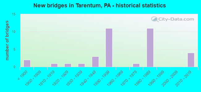
- New bridges - historical statistics
- 2Before 1900
- 11910-1919
- 11920-1929
- 11930-1939
- 31940-1949
- 111950-1959
- 11970-1979
- 111980-1989
- 42010-2019

- Reconstructed bridges - Historical Statistics
- 11950-1959
- 11960-1969
- 01970-1979
- 51980-1989
- 01990-1999
- 12000-2009
- 12010-2019


- Bridge Condition - Deck
- 15.4%Excellent
- 15.4%Very good
- 15.4%Good
- 30.8%Satisfactory
- 23.1%Fair

- Bridge Condition - Superstructure
- 11.8%Excellent
- 5.9%Very good
- 17.6%Good
- 11.8%Satisfactory
- 47.1%Fair
- 5.9%Poor

- Bridge Condition - Substructure
- 17.6%Very good
- 5.9%Good
- 23.5%Satisfactory
- 41.2%Fair
- 11.8%Poor

- Bridge Condition - Channel
- 26.7%Good
- 53.3%Satisfactory
- 13.3%Fair
- 6.7%Poor

- Bridge Condition - Culverts
- 33.3%Very good
- 33.3%Satisfactory
- 33.3%Fair
Find on map >> Show street view
Structure Number: 1108, Location: Tarentum Bridge (Lat: 40.601222, Lng: -79.756861), Route carried "on" structure: State highway 366, Year Built: 1949, Year Reconstructed: 1986, Status: Open, Structure Length: 54.38m (178.41ft), Average Daily Traffic: 27,623 (year 2020), Truck Traffic: 2%, Average Future Daily Traffic: 25,394 (year 2032), Design Load: HS 20, Features Intersected: NSRR (Abdn), Allegheny R, Facility Carried by Structure: Tarentum Bridge
Minimum Vertical Clearance: 9.14m (29.99ft), Kilometerpoint: 1.276, Lanes on structure: 4, Lanes under structure: 4, Base Highway Network: Yes, Owner: State Highway Agency, Approaching Roadway Width: 22.9m (75.1ft), Skew: 30 degrees, Navigation Control: Yes ( Vertical Clearance: 452.9m (1,485.9ft), Horizontal Clearance: 4606.1m (15,111.9ft)), Material/Design: Steel continuous, Design/Construction: Truss - Deck, Number Of Spans In Main Unit: 4, Number Of Approach Spans: 1, Length of Maximum Span: 135.9m (445.9ft), Curb or Sidewalk Widths: Left: 0.2m (0.7ft), Right: 1.5m (4.9ft), Curb-To-Curb Width: 16.2m (53.1ft), Out-to-Out Width: 19.7m (64.6ft)
Condition: Deck: Satisfactory, Superstructure: Fair, Substructure: Satisfactory, Channel: Satisfactory, Operating Rating: 49.0 metric tons, Method Used To Determine Operating Rating: Load Factor (LF), Inventory Rating: 29.0 metric tons, Method Used To Determine Inventory Rating: Load Factor (LF), Structural Evaluation: Somewhat better than minimum adequacy, Deck Geometry: Meets minimum limits, Underclear: Superior to present desirable criteria, Waterway Adequacy: Superior to present desirable criteria, Approach Roadway Alignment: Equal to present desirable criteria, Length Of Structure Improvement: 54.40m (178.48ft), Designated Inspection Frequency: Every 24 months, Critical Feature Inspection Frequency: Every 24 months, Underwater Inspection Frequency: Every 60 months, Inspection Date: August 2021, Critical Feature Inspection Date: August 2021, Underwater Inspection Date: August 2018, Bridge Improvement Cost: $336,000, Roadway Improvement Cost: $989,000, Total Project Cost: $4,534,000, Deck Structure Type: Closed Grating, Wearing Surface/Protective System: Wearing Surface: Bituminous, Membrane: Other
Find on map >> Show street view
Structure Number: 1109, Location: Tarentum Bridge (Lat: 40.595000, Lng: -79.753333), Route carried "on" structure: State highway 366, Year Built: 1952, Year Reconstructed: 1986, Status: Open, Structure Length: 18.65m (61.19ft), Average Daily Traffic: 13,826 (year 2020), Truck Traffic: 2%, Average Future Daily Traffic: 12,642 (year 2032), Design Load: HS 20, Features Intersected: NS RR,4TH AVE,ROSS ST, Facility Carried by Structure: TARENTUM BR,RMP.B
Minimum Vertical Clearance: 5.28m (17.32ft), Kilometerpoint: 1.291, Lanes on structure: 2, Lanes under structure: 10, Base Highway Network: Yes, Owner: State Highway Agency, Approaching Roadway Width: 8.5m (27.9ft), Skew: 9 degrees, Material/Design: Steel, Design/Construction: Stringer/Multi-beam, Number Of Spans In Main Unit: 8, Length of Maximum Span: 25.0m (82.0ft), Curb or Sidewalk Widths: Left: 0.2m (0.7ft), Right: 1.5m (4.9ft), Curb-To-Curb Width: 8.5m (27.9ft), Out-to-Out Width: 11.5m (37.7ft)
Condition: Deck: Satisfactory, Superstructure: Satisfactory, Substructure: Poor, Operating Rating: 85.3 metric tons, Method Used To Determine Operating Rating: Load Factor (LF), Inventory Rating: 50.8 metric tons, Method Used To Determine Inventory Rating: Load Factor (LF), Structural Evaluation: Meets minimum limits, Deck Geometry: High priority of corrective action, Underclear: High priority of corrective action, Approach Roadway Alignment: Equal to present desirable criteria, Length Of Structure Improvement: 19.30m (63.32ft), Designated Inspection Frequency: Every 24 months, Inspection Date: April 2021, Bridge Improvement Cost: $52,000, Roadway Improvement Cost: $154,000, Total Project Cost: $707,000, Deck Structure Type: Concrete Cast-file-Place, Wearing Surface/Protective System: Wearing Surface: Latex Concrete, Deck Protection: Epoxy Coated Reinforcing
Find on map >> Show street view
Structure Number: 1111, Location: Tarentum Bridge (Lat: 40.595000, Lng: -79.753333), Route carried "on" structure: State highway 366, Year Built: 1952, Year Reconstructed: 1986, Status: Open, Structure Length: 17.56m (57.61ft), Average Daily Traffic: 13,797 (year 2020), Truck Traffic: 2%, Average Future Daily Traffic: 12,752 (year 2032), Design Load: HS 20, Features Intersected: 4TH AVE,RAMPD, NS RR, Facility Carried by Structure: RAMP A,TARENTUM BR
Minimum Vertical Clearance: 30+ m (98+ ft), Kilometerpoint: 1.276, Lanes on structure: 2, Lanes under structure: 6, Base Highway Network: Yes, Owner: State Highway Agency, Approaching Roadway Width: 8.5m (27.9ft), Skew: 9 degrees, Material/Design: Steel, Design/Construction: Stringer/Multi-beam, Number Of Spans In Main Unit: 8, Length of Maximum Span: 26.2m (86.0ft), Curb or Sidewalk Widths: Left: 0.2m (0.7ft), Right: 0.2m (0.7ft), Curb-To-Curb Width: 8.1m (26.6ft), Out-to-Out Width: 9.4m (30.8ft)
Condition: Deck: Fair, Superstructure: Satisfactory, Substructure: Poor, Operating Rating: 88.0 metric tons, Method Used To Determine Operating Rating: Load Factor (LF), Inventory Rating: 52.6 metric tons, Method Used To Determine Inventory Rating: Load Factor (LF), Structural Evaluation: Meets minimum limits, Deck Geometry: High priority of replacement, Underclear: High priority of corrective action, Approach Roadway Alignment: Equal to present minimum criteria, Length Of Structure Improvement: 18.30m (60.04ft), Designated Inspection Frequency: Every 24 months, Inspection Date: April 2021, Bridge Improvement Cost: $82,000, Roadway Improvement Cost: $240,000, Total Project Cost: $1,101,000, Deck Structure Type: Concrete Cast-file-Place, Wearing Surface/Protective System: Wearing Surface: Latex Concrete, Deck Protection: Epoxy Coated Reinforcing
Find on map >> Show street view
Structure Number: 1113, Location: @ INTER.W/PLEASANT AVE. (Lat: 40.610908, Lng: -79.756536), Route carried "on" structure: State highway 366, Year Built: 1982, Status: Open, Structure Length: 1.04m (3.41ft), Average Daily Traffic: 24,712 (year 2022), Truck Traffic: 10%, Average Future Daily Traffic: 27,243 (year 2032), Design Load: HS 20, Features Intersected: LITTLE BULL CREEK, Facility Carried by Structure: BULL CREEK RD
Minimum Vertical Clearance: 30+ m (98+ ft), Kilometerpoint: 0.000, Lanes on structure: 6, Base Highway Network: Yes, Owner: State Highway Agency, Approaching Roadway Width: 35.4m (116.1ft), Skew: 20 degrees, Material/Design: Concrete, Design/Construction: Culvert, Number Of Spans In Main Unit: 1, Length of Maximum Span: 10.4m (34.1ft)
Condition: Channel: Satisfactory, Culverts: Satisfactory, Operating Rating: 49.0 metric tons, Method Used To Determine Operating Rating: Field evaluation and documented engineering judgment, Inventory Rating: 32.7 metric tons, Method Used To Determine Inventory Rating: Field evaluation and documented engineering judgment, Structural Evaluation: Equal to present minimum criteria, Waterway Adequacy: Superior to present desirable criteria, Approach Roadway Alignment: Equal to present desirable criteria, Length Of Structure Improvement: 1.00m (3.28ft), Designated Inspection Frequency: Every 24 months, Inspection Date: April 2021
Find on map >> Show street view
Structure Number: 1374, Location: AT APPRCH TO TARENTUM BR (Lat: 40.601678, Lng: -79.758081), Route carried "on" structure: State highway , Year Built: 1895, Status: Open, Structure Length: 1.22m (4.00ft), Average Daily Traffic: 8,047 (year 2022), Truck Traffic: 8%, Average Future Daily Traffic: 13,091 (year 2032), Design Load: HS 20, Features Intersected: BULL CREEK, Facility Carried by Structure: SEVENTH AVE
Minimum Vertical Clearance: 30+ m (98+ ft), Kilometerpoint: 26.852, Lanes on structure: 3, Owner: State Highway Agency, Approaching Roadway Width: 12.2m (40.0ft), Material/Design: Masonry, Design/Construction: Arch - Deck, Number Of Spans In Main Unit: 1, Length of Maximum Span: 12.2m (40.0ft), Curb or Sidewalk Widths: Left: 1.7m (5.6ft), Right: 1.7m (5.6ft), Curb-To-Curb Width: 12.2m (40.0ft), Out-to-Out Width: 16.2m (53.1ft)
Condition: Superstructure: Fair, Substructure: Fair, Channel: Poor, Operating Rating: 49.0 metric tons, Method Used To Determine Operating Rating: Field evaluation and documented engineering judgment, Inventory Rating: 32.7 metric tons, Method Used To Determine Inventory Rating: Field evaluation and documented engineering judgment, Structural Evaluation: Somewhat better than minimum adequacy, Deck Geometry: Meets minimum limits, Waterway Adequacy: Superior to present desirable criteria, Approach Roadway Alignment: Equal to present desirable criteria, Length Of Structure Improvement: 1.20m (3.94ft), Designated Inspection Frequency: Every 24 months, Underwater Inspection Frequency: Every 24 months, Inspection Date: March 2020, Underwater Inspection Date: August 2021, Bridge Improvement Cost: $13,000, Roadway Improvement Cost: $55,000, Total Project Cost: $180,000
Find on map >> Show street view
Structure Number: 144, Location: OFF BAILEY RUN RD. (Lat: 40.601550, Lng: -79.779031), Route carried "on" structure: State highway , Year Built: 1954, Year Reconstructed: 2006, Status: Open, Structure Length: 0.94m (3.08ft), Average Daily Traffic: 472 (year 2021), Truck Traffic: 1%, Average Future Daily Traffic: 725 (year 2032), Design Load: HS 20, Features Intersected: DAYS RUN, Facility Carried by Structure: DAYS RUN RD
Minimum Vertical Clearance: 30+ m (98+ ft), Kilometerpoint: 13.193, Lanes on structure: 2, Owner: State Highway Agency, Approaching Roadway Width: 7.3m (24.0ft), Skew: 4 degrees, Material/Design: Concrete, Design/Construction: Slab, Number Of Spans In Main Unit: 1, Length of Maximum Span: 7.9m (25.9ft), Curb-To-Curb Width: 7.6m (24.9ft), Out-to-Out Width: 8.8m (28.9ft)
Condition: Deck: Very good, Superstructure: Very good, Substructure: Satisfactory, Channel: Satisfactory, Operating Rating: 72.6 metric tons, Method Used To Determine Operating Rating: Load Factor (LF), Inventory Rating: 43.5 metric tons, Method Used To Determine Inventory Rating: Load Factor (LF), Structural Evaluation: Equal to present minimum criteria, Deck Geometry: Meets minimum limits, Waterway Adequacy: Better than present minimum criteria, Approach Roadway Alignment: Equal to present desirable criteria, Length Of Structure Improvement: 0.90m (2.95ft), Designated Inspection Frequency: Every 24 months, Inspection Date: January 2021, Bridge Improvement Cost: $5,000, Roadway Improvement Cost: $35,000, Total Project Cost: $66,000, Wearing Surface/Protective System: Wearing Surface: Monolithic Concrete
Find on map >> Show street view
Structure Number: 1465, Location: 1850' N.E. OF SR 1034 (Lat: 40.643867, Lng: -79.767994), Route carried "on" structure: State highway , Year Built: 1915, Status: Open, Structure Length: 0.76m (2.49ft), Average Daily Traffic: 524 (year 2022), Truck Traffic: 4%, Average Future Daily Traffic: 857 (year 2032), Design Load: HS 20, Features Intersected: HOWES RUN, Facility Carried by Structure: HOWES RUN RD.
Minimum Vertical Clearance: 30+ m (98+ ft), Kilometerpoint: 0.562, Lanes on structure: 2, Owner: State Highway Agency, Approaching Roadway Width: 7.6m (24.9ft), Material/Design: Concrete, Design/Construction: Arch - Deck, Number Of Spans In Main Unit: 1, Length of Maximum Span: 7.6m (24.9ft), Curb-To-Curb Width: 5.8m (19.0ft), Out-to-Out Width: 7.3m (24.0ft)
Condition: Superstructure: Fair, Substructure: Fair, Channel: Satisfactory, Operating Rating: 49.0 metric tons, Method Used To Determine Operating Rating: Field evaluation and documented engineering judgment, Inventory Rating: 32.7 metric tons, Method Used To Determine Inventory Rating: Field evaluation and documented engineering judgment, Structural Evaluation: Somewhat better than minimum adequacy, Deck Geometry: High priority of replacement, Waterway Adequacy: Equal to present minimum criteria, Approach Roadway Alignment: Equal to present desirable criteria, Length Of Structure Improvement: 2.70m (8.86ft), Designated Inspection Frequency: Every 24 months, Inspection Date: January 2021, Bridge Improvement Cost: $9,000, Roadway Improvement Cost: $28,000, Total Project Cost: $126,000
Find on map >> Show street view
Structure Number: 1469, Location: 150' S.E. OF SR 1033 (Lat: 40.639342, Lng: -79.771167), Route carried "on" structure: State highway , Year Built: 1930, Year Reconstructed: 1960, Status: Open, Structure Length: 0.67m (2.20ft), Average Daily Traffic: 2,609 (year 2022), Truck Traffic: 4%, Average Future Daily Traffic: 4,532 (year 2032), Design Load: HS 20, Features Intersected: HOWES RUN, Facility Carried by Structure: BULL CREEK RD
Minimum Vertical Clearance: 30+ m (98+ ft), Kilometerpoint: 2.478, Lanes on structure: 2, Owner: State Highway Agency, Approaching Roadway Width: 10.7m (35.1ft), Material/Design: Masonry, Design/Construction: Arch - Deck, Number Of Spans In Main Unit: 1, Length of Maximum Span: 6.7m (22.0ft), Curb-To-Curb Width: 9.1m (29.9ft), Out-to-Out Width: 10.7m (35.1ft)
Condition: Superstructure: Fair, Substructure: Satisfactory, Channel: Satisfactory, Operating Rating: 49.0 metric tons, Method Used To Determine Operating Rating: Field evaluation and documented engineering judgment, Inventory Rating: 32.7 metric tons, Method Used To Determine Inventory Rating: Field evaluation and documented engineering judgment, Structural Evaluation: Somewhat better than minimum adequacy, Deck Geometry: Meets minimum limits, Waterway Adequacy: Equal to present desirable criteria, Approach Roadway Alignment: Equal to present desirable criteria, Length Of Structure Improvement: 0.70m (2.30ft), Designated Inspection Frequency: Every 24 months, Inspection Date: March 2020, Bridge Improvement Cost: $5,000, Roadway Improvement Cost: $34,000, Total Project Cost: $65,000
Find on map >> Show street view
Structure Number: 1472, Location: 2800' NORTH TWP. RD. 772 (Lat: 40.630519, Lng: -79.763464), Route carried "on" structure: State highway , Year Built: 1922, Status: Open, Structure Length: 1.62m (5.31ft), Average Daily Traffic: 2,609 (year 2022), Truck Traffic: 4%, Average Future Daily Traffic: 4,532 (year 2032), Design Load: HS 20, Features Intersected: BULL CREEK, Facility Carried by Structure: BULL CREEK RD
Minimum Vertical Clearance: 30+ m (98+ ft), Kilometerpoint: 3.708, Lanes on structure: 2, Owner: State Highway Agency, Approaching Roadway Width: 7.6m (24.9ft), Material/Design: Masonry, Design/Construction: Arch - Deck, Number Of Spans In Main Unit: 1, Length of Maximum Span: 16.2m (53.1ft), Curb-To-Curb Width: 6.1m (20.0ft), Out-to-Out Width: 7.3m (24.0ft)
Condition: Superstructure: Fair, Substructure: Fair, Channel: Fair, Operating Rating: 49.0 metric tons, Method Used To Determine Operating Rating: Field evaluation and documented engineering judgment, Inventory Rating: 32.7 metric tons, Method Used To Determine Inventory Rating: Field evaluation and documented engineering judgment, Structural Evaluation: Somewhat better than minimum adequacy, Deck Geometry: High priority of replacement, Waterway Adequacy: Superior to present desirable criteria, Approach Roadway Alignment: Equal to present desirable criteria, Length Of Structure Improvement: 1.60m (5.25ft), Designated Inspection Frequency: Every 24 months, Underwater Inspection Frequency: Every 24 months, Inspection Date: March 2020, Underwater Inspection Date: August 2021, Bridge Improvement Cost: $14,000, Roadway Improvement Cost: $42,000, Total Project Cost: $191,000
Find on map >> Show street view
Structure Number: 1477, Location: NEAR TARENTUM INTERCHANGE (Lat: 40.607572, Lng: -79.763239), Route carried "on" structure: State highway , Year Built: 1983, Status: Open, Structure Length: 6.55m (21.49ft), Average Daily Traffic: 1,036 (year 2022), Truck Traffic: 5%, Average Future Daily Traffic: 2,019 (year 2032), Design Load: HS 20, Features Intersected: SR 0028, Facility Carried by Structure: BAKERSTOWN ROAD
Minimum Vertical Clearance: 30+ m (98+ ft), Kilometerpoint: 0.000, Lanes on structure: 2, Lanes under structure: 8, Owner: State Highway Agency, Approaching Roadway Width: 9.8m (32.2ft), Skew: 1 degrees, Material/Design: Prestressed concrete, Design/Construction: Stringer/Multi-beam, Number Of Spans In Main Unit: 4, Length of Maximum Span: 23.2m (76.1ft), Curb or Sidewalk Widths: Left: 0.2m (0.7ft), Right: 0.2m (0.7ft), Curb-To-Curb Width: 9.1m (29.9ft), Out-to-Out Width: 10.4m (34.1ft)
Condition: Deck: Good, Superstructure: Good, Substructure: Satisfactory, Operating Rating: 79.8 metric tons, Method Used To Determine Operating Rating: Load Factor (LF), Inventory Rating: 29.0 metric tons, Method Used To Determine Inventory Rating: Load Factor (LF), Structural Evaluation: Equal to present minimum criteria, Deck Geometry: Somewhat better than minimum adequacy, Underclear: High priority of corrective action, Approach Roadway Alignment: Somewhat better than minimum adequacy, Length Of Structure Improvement: 6.60m (21.65ft), Designated Inspection Frequency: Every 24 months, Inspection Date: January 2021, Bridge Improvement Cost: $12,000, Roadway Improvement Cost: $43,000, Total Project Cost: $164,000, Deck Structure Type: Concrete Cast-file-Place, Wearing Surface/Protective System: Wearing Surface: Latex Concrete, Deck Protection: Epoxy Coated Reinforcing
Find on map >> Show street view
Structure Number: 2129, Location: DY03 DAYS RUN NO. 3 (Lat: 40.595278, Lng: -79.777800), Route carried "on" structure: County highway , Year Built: 1890, Year Reconstructed: 1957, Status: Open, Structure Length: 0.98m (3.22ft), Average Daily Traffic: 1,899 (year 2005), Truck Traffic: 5%, Average Future Daily Traffic: 1,899 (year 2025), Design Load: HS 20, Features Intersected: DAYS RUN, Facility Carried by Structure: BAILEYS RUN RD
Minimum Vertical Clearance: 30+ m (98+ ft), Kilometerpoint: 0.000, Lanes on structure: 2, Owner: County Highway Agency, Approaching Roadway Width: 8.5m (27.9ft), Skew: 1 degrees, Material/Design: Prestressed concrete, Design/Construction: Box Beam or Girders - Multiple, Number Of Spans In Main Unit: 1, Length of Maximum Span: 9.4m (30.8ft), Curb or Sidewalk Widths: Left: 1.1m (3.6ft), Right: 0.2m (0.7ft), Curb-To-Curb Width: 6.9m (22.6ft), Out-to-Out Width: 8.3m (27.2ft)
Condition: Deck: Fair, Superstructure: Poor, Substructure: Fair, Channel: Fair, Operating Rating: 63.5 metric tons, Method Used To Determine Operating Rating: Load Factor (LF), Inventory Rating: 36.3 metric tons, Method Used To Determine Inventory Rating: Load Factor (LF), Structural Evaluation: Meets minimum limits, Deck Geometry: High priority of corrective action, Waterway Adequacy: Equal to present desirable criteria, Approach Roadway Alignment: Equal to present desirable criteria, Length Of Structure Improvement: 1.00m (3.28ft), Designated Inspection Frequency: Every 24 months, Inspection Date: October 2021, Bridge Improvement Cost: $8,000, Roadway Improvement Cost: $59,000, Total Project Cost: $113,000, Deck Structure Type: Other, Wearing Surface/Protective System: Wearing Surface: Bituminous
Find on map >> Show street view
Structure Number: 2256, Location: 202001 OVER BULL CREEK (Lat: 40.615558, Lng: -79.760450), Route carried "on" structure: ServiceCity street , Year Built: 1984, Status: Open, Structure Length: 1.19m (3.90ft), Average Daily Traffic: 50 (year 2019), Truck Traffic: 6%, Average Future Daily Traffic: 50 (year 2040), Design Load: HS 20, Features Intersected: BULL CREEK, Facility Carried by Structure: GRIMM RD
Minimum Vertical Clearance: 30+ m (98+ ft), Kilometerpoint: 0.000, Lanes on structure: 2, Owner: Town or Township Highway Agency, Approaching Roadway Width: 7.6m (24.9ft), Skew: 3 degrees, Material/Design: Steel, Design/Construction: Culvert, Number Of Spans In Main Unit: 1, Length of Maximum Span: 11.6m (38.1ft)
Condition: Channel: Good, Culverts: Fair, Operating Rating: 54.4 metric tons, Method Used To Determine Operating Rating: Field evaluation and documented engineering judgment, Inventory Rating: 32.7 metric tons, Method Used To Determine Inventory Rating: Field evaluation and documented engineering judgment, Structural Evaluation: Somewhat better than minimum adequacy, Waterway Adequacy: Better than present minimum criteria, Approach Roadway Alignment: Equal to present desirable criteria, Length Of Structure Improvement: 1.20m (3.94ft), Designated Inspection Frequency: Every 24 months, Inspection Date: March 2021
Find on map >> Show street view
Structure Number: 2687, Location: 464001 MILL STREET (Lat: 40.603647, Lng: -79.759492), Route carried "on" structure: City street , Year Built: 1989, Status: Open, Structure Length: 2.19m (7.19ft), Average Daily Traffic: 250 (year 2021), Truck Traffic: 5%, Average Future Daily Traffic: 295 (year 2043), Design Load: HS 25 or greater, Features Intersected: BULL CREEK, Facility Carried by Structure: MILL ST
Minimum Vertical Clearance: 30+ m (98+ ft), Kilometerpoint: 0.000, Lanes on structure: 2, Owner: Town or Township Highway Agency, Approaching Roadway Width: 6.7m (22.0ft), Material/Design: Prestressed concrete, Design/Construction: Box Beam or Girders - Multiple, Number Of Spans In Main Unit: 1, Length of Maximum Span: 21.0m (68.9ft), Curb or Sidewalk Widths: Left: 1.5m (4.9ft), Right: 0.2m (0.7ft), Curb-To-Curb Width: 7.5m (24.6ft), Out-to-Out Width: 9.8m (32.2ft)
Condition: Deck: Fair, Superstructure: Fair, Substructure: Good, Channel: Good, Inventory Rating: 35.4 metric tons, Method Used To Determine Inventory Rating: Load Factor (LF), Structural Evaluation: Somewhat better than minimum adequacy, Deck Geometry: Somewhat better than minimum adequacy, Waterway Adequacy: Better than present minimum criteria, Approach Roadway Alignment: Equal to present desirable criteria, Length Of Structure Improvement: 2.10m (6.89ft), Designated Inspection Frequency: Every 24 months, Inspection Date: June 2021, Deck Structure Type: Concrete Cast-file-Place, Wearing Surface/Protective System: Wearing Surface: Monolithic Concrete
Find on map >> Show street view
Structure Number: 2688, Location: 464002 200' W OF ROSS ST (Lat: 40.600175, Lng: -79.757447), Route carried "on" structure: City street , Year Built: 1970, Year Reconstructed: 2017, Status: Open, Structure Length: 1.98m (6.50ft), Average Daily Traffic: 3,000 (year 2021), Truck Traffic: 5%, Average Future Daily Traffic: 3,500 (year 2041), Design Load: HL 93, Features Intersected: BULL CREEK, Facility Carried by Structure: FOURTH AV
Minimum Vertical Clearance: 30+ m (98+ ft), Kilometerpoint: 0.000, Lanes on structure: 2, Owner: City or Municipal Highway Agency, Approaching Roadway Width: 11.0m (36.1ft), Skew: 2 degrees, Material/Design: Steel, Design/Construction: Stringer/Multi-beam, Number Of Spans In Main Unit: 1, Length of Maximum Span: 18.3m (60.0ft), Curb or Sidewalk Widths: Left: 1.8m (5.9ft), Right: 0.2m (0.7ft), Curb-To-Curb Width: 11.0m (36.1ft), Out-to-Out Width: 13.6m (44.6ft)
Condition: Deck: Good, Superstructure: Good, Substructure: Fair, Channel: Satisfactory, Operating Rating: 73.9 metric tons, Method Used To Determine Operating Rating: Assigned ratings based on Load and Resistance Factor Design (LRFD) reported by rating factor (RF) using HL93 loadings, Inventory Rating: 57.0 metric tons, Method Used To Determine Inventory Rating: Assigned ratings based on Load and Resistance Factor Design (LRFD) reported by rating factor (RF) using HL93 loadings, Structural Evaluation: Somewhat better than minimum adequacy, Deck Geometry: Somewhat better than minimum adequacy, Waterway Adequacy: Better than present minimum criteria, Approach Roadway Alignment: Equal to present desirable criteria, Length Of Structure Improvement: 1.90m (6.23ft), Designated Inspection Frequency: Every 24 months, Underwater Inspection Frequency: Every 60 months, Inspection Date: October 2021, Underwater Inspection Date: June 2019, Bridge Improvement Cost: $23,000, Roadway Improvement Cost: $94,000, Total Project Cost: $306,000, Deck Structure Type: Concrete Cast-file-Place, Wearing Surface/Protective System: Wearing Surface: Monolithic Concrete, Deck Protection: Epoxy Coated Reinforcing
Find on map >> Show street view
Structure Number: 2901, Location: Tarentum Bridge (Lat: 40.595000, Lng: -79.753333), Route carried "on" structure: Ramp State highway , Year Built: 1952, Year Reconstructed: 1986, Status: Open, Structure Length: 9.36m (30.71ft), Average Daily Traffic: 1,938 (year 2022), Truck Traffic: 7%, Average Future Daily Traffic: 6,862 (year 2032), Design Load: HS 20, Features Intersected: 4TH AVE, PARKING LOT, Facility Carried by Structure: RAMP D
Minimum Vertical Clearance: 4.50m (14.76ft), Kilometerpoint: 0.000, Lanes on structure: 1, Lanes under structure: 2, Base Highway Network: Yes, Owner: State Highway Agency, Approaching Roadway Width: 5.5m (18.0ft), Skew: 9 degrees, Material/Design: Steel, Design/Construction: Stringer/Multi-beam, Number Of Spans In Main Unit: 4, Length of Maximum Span: 25.0m (82.0ft), Curb or Sidewalk Widths: Left: 0.2m (0.7ft), Right: 0.2m (0.7ft), Curb-To-Curb Width: 5.5m (18.0ft), Out-to-Out Width: 6.7m (22.0ft)
Condition: Deck: Satisfactory, Superstructure: Fair, Substructure: Fair, Operating Rating: 91.6 metric tons, Method Used To Determine Operating Rating: Load Factor (LF), Inventory Rating: 54.4 metric tons, Method Used To Determine Inventory Rating: Load Factor (LF), Structural Evaluation: Somewhat better than minimum adequacy, Deck Geometry: Meets minimum limits, Underclear: Equal to present minimum criteria, Approach Roadway Alignment: Equal to present desirable criteria, Length Of Structure Improvement: 10.30m (33.79ft), Designated Inspection Frequency: Every 24 months, Inspection Date: April 2021, Bridge Improvement Cost: $16,000, Roadway Improvement Cost: $48,000, Total Project Cost: $219,000, Deck Structure Type: Concrete Cast-file-Place, Wearing Surface/Protective System: Wearing Surface: Monolithic Concrete
Find on map >> Show street view
Structure Number: 2902, Location: Tarentum Bridge (Lat: 40.595000, Lng: -79.753333), Route carried "on" structure: Ramp State highway , Year Built: 1952, Year Reconstructed: 1986, Status: Open, Structure Length: 9.85m (32.32ft), Average Daily Traffic: 1,458 (year 2022), Truck Traffic: 7%, Average Future Daily Traffic: 6,659 (year 2032), Design Load: HS 20, Features Intersected: 4TH AVE, PARKING LOT, Facility Carried by Structure: RAMP C
Minimum Vertical Clearance: 30+ m (98+ ft), Kilometerpoint: 0.000, Lanes on structure: 1, Lanes under structure: 3, Base Highway Network: Yes, Owner: State Highway Agency, Approaching Roadway Width: 5.5m (18.0ft), Skew: 9 degrees, Material/Design: Steel, Design/Construction: Stringer/Multi-beam, Number Of Spans In Main Unit: 5, Length of Maximum Span: 19.5m (64.0ft), Curb or Sidewalk Widths: Left: 0.2m (0.7ft), Right: 0.2m (0.7ft), Curb-To-Curb Width: 5.5m (18.0ft), Out-to-Out Width: 6.7m (22.0ft)
Condition: Deck: Satisfactory, Superstructure: Fair, Substructure: Fair, Operating Rating: 92.5 metric tons, Method Used To Determine Operating Rating: Load Factor (LF), Inventory Rating: 55.3 metric tons, Method Used To Determine Inventory Rating: Load Factor (LF), Structural Evaluation: Somewhat better than minimum adequacy, Deck Geometry: Meets minimum limits, Underclear: Superior to present desirable criteria, Approach Roadway Alignment: Equal to present minimum criteria, Length Of Structure Improvement: 10.90m (35.76ft), Designated Inspection Frequency: Every 24 months, Inspection Date: April 2021, Bridge Improvement Cost: $17,000, Roadway Improvement Cost: $51,000, Total Project Cost: $233,000, Deck Structure Type: Concrete Cast-file-Place, Wearing Surface/Protective System: Wearing Surface: Monolithic Concrete, Deck Protection: Epoxy Coated Reinforcing
Find on map >> Show street view
Structure Number: 52675, Location: 200' West of SR 1031 (Lat: 40.652014, Lng: -79.793475), Route carried "on" structure: State highway , Year Built: 2015, Status: Open, Structure Length: 1.80m (5.91ft), Average Daily Traffic: 2,982 (year 2022), Truck Traffic: 4%, Average Future Daily Traffic: 3,415 (year 2034), Design Load: HL 93, Features Intersected: Lardintown Run, Facility Carried by Structure: Bakerstown Rd
Minimum Vertical Clearance: 30+ m (98+ ft), Kilometerpoint: 12.965, Lanes on structure: 2, Base Highway Network: Yes, Owner: State Highway Agency, Maintenance Responsibility: Private, Approaching Roadway Width: 8.5m (27.9ft), Material/Design: Prestressed concrete, Design/Construction: Box Beam or Girders - Single/Spread, Number Of Spans In Main Unit: 1, Length of Maximum Span: 17.7m (58.1ft), Curb-To-Curb Width: 9.1m (29.9ft), Out-to-Out Width: 9.8m (32.2ft)
Condition: Deck: Excellent, Superstructure: Excellent, Substructure: Very good, Channel: Good, Operating Rating: 63.8 metric tons, Method Used To Determine Operating Rating: Assigned ratings based on Load and Resistance Factor Design (LRFD) reported by rating factor (RF) using HL93 loadings, Inventory Rating: 49.2 metric tons, Method Used To Determine Inventory Rating: Assigned ratings based on Load and Resistance Factor Design (LRFD) reported by rating factor (RF) using HL93 loadings, Structural Evaluation: Equal to present desirable criteria, Deck Geometry: Meets minimum limits, Waterway Adequacy: Superior to present desirable criteria, Approach Roadway Alignment: Equal to present desirable criteria, Designated Inspection Frequency: Every 24 months, Inspection Date: September 2021, Deck Structure Type: Concrete Cast-file-Place, Wearing Surface/Protective System: Wearing Surface: Integral Concrete, Deck Protection: Epoxy Coated Reinforcing
Find on map >> Show street view
Structure Number: 52755, Location: 4200' S.E. OF SR 1033 (Lat: 40.632100, Lng: -79.761100), Route carried "on" structure: State highway , Year Built: 2015, Status: Open, Structure Length: 2.26m (7.41ft), Average Daily Traffic: 2,609 (year 2022), Truck Traffic: 4%, Average Future Daily Traffic: 4,532 (year 2032), Design Load: HL 93, Features Intersected: BULL CREEK, Facility Carried by Structure: BULL CREEK RD
Minimum Vertical Clearance: 30+ m (98+ ft), Kilometerpoint: 3.708, Lanes on structure: 2, Owner: State Highway Agency, Maintenance Responsibility: Private, Approaching Roadway Width: 9.4m (30.8ft), Skew: 1 degrees, Material/Design: Prestressed concrete, Design/Construction: Box Beam or Girders - Single/Spread, Number Of Spans In Main Unit: 1, Length of Maximum Span: 22.3m (73.2ft), Curb-To-Curb Width: 9.2m (30.2ft), Out-to-Out Width: 9.9m (32.5ft)
Condition: Deck: Excellent, Superstructure: Excellent, Substructure: Very good, Channel: Good, Operating Rating: 52.8 metric tons, Method Used To Determine Operating Rating: Assigned ratings based on Load and Resistance Factor Design (LRFD) reported by rating factor (RF) using HL93 loadings, Inventory Rating: 40.8 metric tons, Method Used To Determine Inventory Rating: Assigned ratings based on Load and Resistance Factor Design (LRFD) reported by rating factor (RF) using HL93 loadings, Structural Evaluation: Equal to present desirable criteria, Deck Geometry: Meets minimum limits, Waterway Adequacy: Superior to present desirable criteria, Approach Roadway Alignment: Better than present minimum criteria, Designated Inspection Frequency: Every 24 months, Inspection Date: September 2021, Deck Structure Type: Concrete Cast-file-Place, Wearing Surface/Protective System: Wearing Surface: Integral Concrete, Deck Protection: Epoxy Coated Reinforcing
Find on map >> Show street view
Structure Number: 5333, Location: Near Bailey Run Rd (Lat: 40.598508, Lng: -79.777869), Route carried "on" structure: State highway , Year Built: 2018, Status: Open, Structure Length: 0.79m (2.59ft), Average Daily Traffic: 472 (year 2021), Truck Traffic: 1%, Average Future Daily Traffic: 600 (year 2038), Design Load: HL 93, Features Intersected: Days Run, Facility Carried by Structure: Days Run Road
Minimum Vertical Clearance: 30+ m (98+ ft), Kilometerpoint: 13.193, Lanes on structure: 2, Owner: State Highway Agency, Approaching Roadway Width: 7.3m (24.0ft), Skew: 4 degrees, Material/Design: Concrete, Design/Construction: Culvert, Number Of Spans In Main Unit: 1, Length of Maximum Span: 7.9m (25.9ft), Curb-To-Curb Width: 7.7m (25.3ft), Out-to-Out Width: 12.6m (41.3ft)
Condition: Channel: Satisfactory, Culverts: Very good, Operating Rating: 52.8 metric tons, Method Used To Determine Operating Rating: Assigned ratings based on Load and Resistance Factor Design (LRFD) reported by rating factor (RF) using HL93 loadings, Inventory Rating: 38.2 metric tons, Method Used To Determine Inventory Rating: Assigned ratings based on Load and Resistance Factor Design (LRFD) reported by rating factor (RF) using HL93 loadings, Structural Evaluation: Equal to present desirable criteria, Deck Geometry: Meets minimum limits, Waterway Adequacy: Superior to present desirable criteria, Approach Roadway Alignment: Equal to present desirable criteria, Designated Inspection Frequency: Every 24 months, Inspection Date: January 2021
Find on map >> Show street view
Structure Number: 54344, Location: 350' N OF SR 1034 (Lat: 40.648750, Lng: -79.790722), Route carried "on" structure: State highway , Year Built: 2019, Status: Open, Structure Length: 2.35m (7.71ft), Average Daily Traffic: 517 (year 2022), Truck Traffic: 9%, Average Future Daily Traffic: 600 (year 2030), Design Load: HL 93, Features Intersected: Bull Creek, Facility Carried by Structure: Lardington Road
Minimum Vertical Clearance: 30+ m (98+ ft), Kilometerpoint: 0.000, Lanes on structure: 2, Owner: State Highway Agency, Approaching Roadway Width: 8.5m (27.9ft), Skew: 2 degrees, Material/Design: Steel, Design/Construction: Stringer/Multi-beam, Number Of Spans In Main Unit: 1, Length of Maximum Span: 21.9m (71.9ft), Curb or Sidewalk Widths: Left: 0.2m (0.7ft), Right: 0.2m (0.7ft), Curb-To-Curb Width: 8.5m (27.9ft), Out-to-Out Width: 9.6m (31.5ft)
Condition: Deck: Very good, Superstructure: Good, Substructure: Very good, Channel: Satisfactory, Operating Rating: 60.9 metric tons, Method Used To Determine Operating Rating: Assigned ratings based on Load and Resistance Factor Design (LRFD) reported by rating factor (RF) using HL93 loadings, Inventory Rating: 46.7 metric tons, Method Used To Determine Inventory Rating: Assigned ratings based on Load and Resistance Factor Design (LRFD) reported by rating factor (RF) using HL93 loadings, Structural Evaluation: Better than present minimum criteria, Deck Geometry: Somewhat better than minimum adequacy, Waterway Adequacy: Equal to present desirable criteria, Approach Roadway Alignment: Equal to present desirable criteria, Designated Inspection Frequency: Every 24 months, Inspection Date: January 2021, Deck Structure Type: Concrete Cast-file-Place, Wearing Surface/Protective System: Wearing Surface: Monolithic Concrete, Deck Protection: Epoxy Coated Reinforcing
Find on map >> Show street view
Structure Number: 649, Location: TARENTUM INTERCHANGE (Lat: 40.613325, Lng: -79.757250), Route carried "under" structure: State highway 366, Year Built: 1984, Structure Length: 0. m, Average Daily Traffic: 11,925 (year 2022), Truck Traffic: 11%, Features Intersected: SR 1034 -BULL CREEK ROAD, Facility Carried by Structure: ROUTE 28 N.B.
Minimum Vertical Clearance: 30+ m (98+ ft), Kilometerpoint: 0.000, Lanes on structure: 2, Lanes under structure: 5, Material/Design: Prestressed concrete, Design/Construction: Box Beam or Girders - Multiple, Length of Maximum Span: 31.1m (102.0ft)
Find on map >> Show street view
Structure Number: 649, Location: TARENTUM INTERCHANGE (Lat: 40.613325, Lng: -79.757250), Route carried "under" structure: State highway , Year Built: 1984, Structure Length: 0. m, Average Daily Traffic: 2,078 (year 2022), Truck Traffic: 8%, Features Intersected: SR 1034 -BULL CREEK ROAD, Facility Carried by Structure: ROUTE 28 N.B.
Minimum Vertical Clearance: 5.43m (17.81ft), Kilometerpoint: 6.297, Lanes on structure: 2, Lanes under structure: 5, Material/Design: Prestressed concrete, Design/Construction: Box Beam or Girders - Multiple, Length of Maximum Span: 31.1m (102.0ft)
Find on map >> Show street view
Structure Number: 649, Location: TARENTUM INTERCHANGE (Lat: 40.613325, Lng: -79.757250), Route carried "under" structure: State highway , Year Built: 1984, Structure Length: 0. m, Average Daily Traffic: 1,732 (year 2022), Truck Traffic: 5%, Features Intersected: SR 1034 -BULL CREEK ROAD, Facility Carried by Structure: ROUTE 28 N.B.
Minimum Vertical Clearance: 5.43m (17.81ft), Kilometerpoint: 6.297, Lanes on structure: 2, Lanes under structure: 4, Material/Design: Prestressed concrete, Design/Construction: Box Beam or Girders - Multiple, Length of Maximum Span: 31.1m (102.0ft)
Find on map >> Show street view
Structure Number: 65, Location: TARENTUM INTERCHANGE (Lat: 40.613403, Lng: -79.757472), Route carried "under" structure: State highway , Year Built: 1984, Structure Length: 0. m, Average Daily Traffic: 1,732 (year 2022), Truck Traffic: 5%, Features Intersected: SR 1034-BULL CREEK ROAD, Facility Carried by Structure: SR 0028 SB
Minimum Vertical Clearance: 5.76m (18.90ft), Kilometerpoint: 6.297, Lanes on structure: 3, Lanes under structure: 4, Material/Design: Prestressed concrete, Design/Construction: Box Beam or Girders - Multiple, Length of Maximum Span: 31.1m (102.0ft)
Find on map >> Show street view
Structure Number: 65, Location: TARENTUM INTERCHANGE (Lat: 40.613403, Lng: -79.757472), Route carried "under" structure: State highway , Year Built: 1984, Structure Length: 0. m, Average Daily Traffic: 2,078 (year 2022), Truck Traffic: 8%, Features Intersected: SR 1034-BULL CREEK ROAD, Facility Carried by Structure: SR 0028 SB
Minimum Vertical Clearance: 5.76m (18.90ft), Kilometerpoint: 6.297, Lanes on structure: 3, Lanes under structure: 4, Material/Design: Prestressed concrete, Design/Construction: Box Beam or Girders - Multiple, Length of Maximum Span: 31.1m (102.0ft)
Find on map >> Show street view
Structure Number: 1108, Location: Tarentum Bridge (Lat: 40.601222, Lng: -79.756861), Route carried "under" structure: Ramp State highway , Year Built: 1949, Structure Length: 0. m, Average Daily Traffic: 1,458 (year 2022), Truck Traffic: 7%, Features Intersected: NSRR (Abdn), Allegheny R, Facility Carried by Structure: Tarentum Bridge
Minimum Vertical Clearance: 7.77m (25.49ft), Kilometerpoint: 0.000, Lanes on structure: 4, Lanes under structure: 2, Material/Design: Steel continuous, Design/Construction: Truss - Deck, Length of Maximum Span: 135.9m (445.9ft)
Find on map >> Show street view
Structure Number: 1108, Location: Tarentum Bridge (Lat: 40.601222, Lng: -79.756861), Route carried "under" structure: Ramp State highway , Year Built: 1949, Structure Length: 0. m, Average Daily Traffic: 1,938 (year 2022), Truck Traffic: 7%, Features Intersected: NSRR (Abdn), Allegheny R, Facility Carried by Structure: Tarentum Bridge
Minimum Vertical Clearance: 7.41m (24.31ft), Kilometerpoint: 0.000, Lanes on structure: 4, Lanes under structure: 2, Material/Design: Steel continuous, Design/Construction: Truss - Deck, Length of Maximum Span: 135.9m (445.9ft)
Find on map >> Show street view
Structure Number: 1109, Location: Tarentum Bridge (Lat: 40.595000, Lng: -79.753333), Route carried "under" structure: City street , Year Built: 1952, Structure Length: 0. m, Average Daily Traffic: 101 (year 2005), Truck Traffic: 7%, Features Intersected: NS RR,4TH AVE,ROSS ST, Facility Carried by Structure: TARENTUM BR,RMP.B
Minimum Vertical Clearance: 9.14m (29.99ft), Kilometerpoint: 0.000, Lanes on structure: 2, Lanes under structure: 5, Material/Design: Steel, Design/Construction: Stringer/Multi-beam, Length of Maximum Span: 25.0m (82.0ft)
Find on map >> Show street view
Structure Number: 1109, Location: Tarentum Bridge (Lat: 40.595000, Lng: -79.753333), Route carried "under" structure: City street , Year Built: 1952, Structure Length: 0. m, Average Daily Traffic: 101 (year 2005), Truck Traffic: 7%, Features Intersected: NS RR,4TH AVE,ROSS ST, Facility Carried by Structure: TARENTUM BR,RMP.B
Minimum Vertical Clearance: 5.76m (18.90ft), Kilometerpoint: 0.000, Lanes on structure: 2, Lanes under structure: 5, Material/Design: Steel, Design/Construction: Stringer/Multi-beam, Length of Maximum Span: 25.0m (82.0ft)
Find on map >> Show street view
Structure Number: 1111, Location: Tarentum Bridge (Lat: 40.595000, Lng: -79.753333), Route carried "under" structure: Ramp State highway , Year Built: 1952, Structure Length: 0. m, Average Daily Traffic: 1,938 (year 2022), Truck Traffic: 7%, Features Intersected: 4TH AVE,RAMPD, NS RR, Facility Carried by Structure: RAMP A,TARENTUM BR
Minimum Vertical Clearance: 4.52m (14.83ft), Kilometerpoint: 0.000, Lanes on structure: 2, Lanes under structure: 3, Material/Design: Steel, Design/Construction: Stringer/Multi-beam, Length of Maximum Span: 26.2m (86.0ft)
Find on map >> Show street view
Structure Number: 1111, Location: Tarentum Bridge (Lat: 40.595000, Lng: -79.753333), Route carried "under" structure: City street , Year Built: 1952, Structure Length: 0. m, Average Daily Traffic: 101 (year 2005), Truck Traffic: 7%, Features Intersected: 4TH AVE,RAMPD, NS RR, Facility Carried by Structure: RAMP A,TARENTUM BR
Minimum Vertical Clearance: 9.14m (29.99ft), Kilometerpoint: 0.000, Lanes on structure: 2, Lanes under structure: 3, Material/Design: Steel, Design/Construction: Stringer/Multi-beam, Length of Maximum Span: 26.2m (86.0ft)
Find on map >> Show street view
Structure Number: 1477, Location: NEAR TARENTUM INTERCHANGE (Lat: 40.607572, Lng: -79.763239), Route carried "under" structure: State highway 28, Year Built: 1983, Structure Length: 0. m, Average Daily Traffic: 17,720 (year 2020), Truck Traffic: 14%, Features Intersected: SR 0028, Facility Carried by Structure: BAKERSTOWN ROAD
Minimum Vertical Clearance: 4.67m (15.32ft), Kilometerpoint: 30.030, Lanes on structure: 2, Lanes under structure: 4, Material/Design: Prestressed concrete, Design/Construction: Stringer/Multi-beam, Length of Maximum Span: 23.2m (76.1ft)
Find on map >> Show street view
Structure Number: 1477, Location: NEAR TARENTUM INTERCHANGE (Lat: 40.607572, Lng: -79.763239), Route carried "under" structure: State highway 28, Year Built: 1983, Structure Length: 0. m, Average Daily Traffic: 18,411 (year 2020), Truck Traffic: 11%, Features Intersected: SR 0028, Facility Carried by Structure: BAKERSTOWN ROAD
Minimum Vertical Clearance: 4.67m (15.32ft), Kilometerpoint: 29.974, Lanes on structure: 2, Lanes under structure: 4, Material/Design: Prestressed concrete, Design/Construction: Stringer/Multi-beam, Length of Maximum Span: 23.2m (76.1ft)
Find on map >> Show street view
Structure Number: 2901, Location: Tarentum Bridge (Lat: 40.595000, Lng: -79.753333), Route carried "under" structure: City street , Year Built: 1952, Structure Length: 0. m, Average Daily Traffic: 101 (year 1997), Truck Traffic: 7%, Features Intersected: 4TH AVE, PARKING LOT, Facility Carried by Structure: RAMP D
Minimum Vertical Clearance: 7.77m (25.49ft), Kilometerpoint: 0.000, Lanes on structure: 1, Lanes under structure: 2, Material/Design: Steel, Design/Construction: Stringer/Multi-beam, Length of Maximum Span: 25.0m (82.0ft)
Find on map >> Show street view
Structure Number: 2902, Location: Tarentum Bridge (Lat: 40.595000, Lng: -79.753333), Route carried "under" structure: City street , Year Built: 1952, Structure Length: 0. m, Average Daily Traffic: 5 (year 2005), Truck Traffic: 1%, Features Intersected: 4TH AVE, PARKING LOT, Facility Carried by Structure: RAMP C
Minimum Vertical Clearance: 7.77m (25.49ft), Kilometerpoint: 0.000, Lanes on structure: 1, Lanes under structure: 3, Material/Design: Steel, Design/Construction: Stringer/Multi-beam, Length of Maximum Span: 19.5m (64.0ft)