Bridge Statistics for Tangipahoa, Louisiana (LA)
Condition, Traffic, Stress, Structural Evaluation, Project Costs
- National Bridge Inventory (NBI) Statistics
- 29Number of bridges
- 404ft / 123mTotal length
- $4,457,000Total costs
- 253,059Total average daily traffic
- 30,332Total average daily truck traffic
- National Bridge Inventory (NBI) Registered Bridges for Tangipahoa
- No street view available for this location
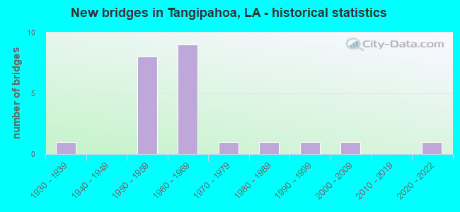
- New bridges - historical statistics
- 11930-1939
- 81950-1959
- 91960-1969
- 11970-1979
- 11980-1989
- 11990-1999
- 12000-2009
- 12020-2022


- Bridge Condition - Deck
- 7.1%Excellent
- 57.1%Good
- 28.6%Satisfactory
- 7.1%Fair

- Bridge Condition - Superstructure
- 7.1%Excellent
- 21.4%Very good
- 42.9%Good
- 14.3%Satisfactory
- 14.3%Fair

- Bridge Condition - Substructure
- 7.1%Excellent
- 14.3%Very good
- 50.0%Good
- 7.1%Satisfactory
- 14.3%Fair
- 7.1%Serious

- Bridge Condition - Channel
- 15.0%Very good
- 50.0%Good
- 30.0%Satisfactory
- 5.0%Fair

- Bridge Condition - Culverts
- 11.1%Very good
- 77.8%Good
- 11.1%Satisfactory
Find on map >> Show street view
Structure Number: 625300000625306, Location: 1.8 Mi N. of LA 10 (Lat: 30.850800, Lng: -90.511469), Route carried "on" structure: US 51, Year Built: 2021, Status: Open, Structure Length: 1.83m (6.00ft), Average Daily Traffic: 2,034 (year 2020), Truck Traffic: 12%, Average Future Daily Traffic: 2,260 (year 2050), Design Load: Greater than HL93, Features Intersected: Drain
Minimum Vertical Clearance: 30+ m (98+ ft), Kilometerpoint: 2.878, Lanes on structure: 2, Base Highway Network: Yes (Inventory Route: 17-06-1, Subroute: 10), Owner: State Highway Agency, Approaching Roadway Width: 9.1m (29.9ft), Material/Design: Concrete, Design/Construction: Slab, Number Of Spans In Main Unit: 3, Length of Maximum Span: 6.1m (20.0ft), Curb-To-Curb Width: 9.8m (32.2ft), Out-to-Out Width: 10.5m (34.4ft)
Condition: Deck: Excellent, Superstructure: Excellent, Substructure: Excellent, Channel: Very good, Operating Rating: 72.9 metric tons, Method Used To Determine Operating Rating: Load and Resistance Factor Rating (LRFR) rating reported by rating factor(RF) method using HL-93 loadings, Inventory Rating: 56.4 metric tons, Method Used To Determine Inventory Rating: Load and Resistance Factor Rating (LRFR) rating reported by rating factor(RF) method using HL-93 loadings, Structural Evaluation: Superior to present desirable criteria, Deck Geometry: Meets minimum limits, Waterway Adequacy: Equal to present desirable criteria, Approach Roadway Alignment: Equal to present desirable criteria, Designated Inspection Frequency: Every 24 months, Inspection Date: October 2021, Deck Structure Type: Concrete Precast Panels
Find on map >> Show street view
Structure Number: 625300170600151, Location: 0.1 M N OF LA 10 (Lat: 30.827019, Lng: -90.510900), Route carried "on" structure: US 51, Year Built: 1956, Status: Open, Structure Length: 1.43m (4.69ft), Average Daily Traffic: 2,700 (year 2016), Truck Traffic: 12%, Average Future Daily Traffic: 1,890 (year 2036), Design Load: H 15, Features Intersected: CARPENTER BRANCH
Minimum Vertical Clearance: 30+ m (98+ ft), Kilometerpoint: 0.241, Lanes on structure: 2, Owner: State Highway Agency, Approaching Roadway Width: 12.2m (40.0ft), Material/Design: Concrete, Design/Construction: Culvert, Number Of Spans In Main Unit: 7, Length of Maximum Span: 1.8m (5.9ft), Curb-To-Curb Width: 12.2m (40.0ft), Out-to-Out Width: 14.7m (48.2ft)
Condition: Channel: Satisfactory, Culverts: Satisfactory, Operating Rating: 27.9 metric tons, Method Used To Determine Operating Rating: Load and Resistance Factor Rating (LRFR) rating reported by rating factor(RF) method using HL-93 loadings, Inventory Rating: 21.7 metric tons, Method Used To Determine Inventory Rating: Load and Resistance Factor Rating (LRFR) rating reported by rating factor(RF) method using HL-93 loadings, Structural Evaluation: Somewhat better than minimum adequacy, Deck Geometry: Equal to present minimum criteria, Waterway Adequacy: Equal to present minimum criteria, Approach Roadway Alignment: Equal to present desirable criteria, Designated Inspection Frequency: Every 24 months, Inspection Date: April 2021, Deck Structure Type: Concrete Cast-file-Place
Find on map >> Show street view
Structure Number: 625300170600881, Location: 0.8 M N OF LA 10 (Lat: 30.837561, Lng: -90.511100), Route carried "on" structure: US 51, Year Built: 1956, Status: Open, Structure Length: 0.85m (2.79ft), Average Daily Traffic: 2,700 (year 2016), Truck Traffic: 12%, Average Future Daily Traffic: 1,890 (year 2036), Design Load: H 15, Features Intersected: DRAIN
Minimum Vertical Clearance: 30+ m (98+ ft), Kilometerpoint: 1.410, Lanes on structure: 2, Owner: State Highway Agency, Approaching Roadway Width: 12.2m (40.0ft), Material/Design: Concrete, Design/Construction: Culvert, Number Of Spans In Main Unit: 6, Length of Maximum Span: 1.2m (3.9ft), Curb-To-Curb Width: 12.2m (40.0ft), Out-to-Out Width: 14.7m (48.2ft)
Condition: Channel: Satisfactory, Culverts: Good, Operating Rating: 42.1 metric tons, Method Used To Determine Operating Rating: Load and Resistance Factor Rating (LRFR) rating reported by rating factor(RF) method using HL-93 loadings, Inventory Rating: 32.4 metric tons, Method Used To Determine Inventory Rating: Load and Resistance Factor Rating (LRFR) rating reported by rating factor(RF) method using HL-93 loadings, Structural Evaluation: Better than present minimum criteria, Deck Geometry: Equal to present minimum criteria, Waterway Adequacy: Better than present minimum criteria, Approach Roadway Alignment: Equal to present desirable criteria, Designated Inspection Frequency: Every 24 months, Inspection Date: April 2021, Deck Structure Type: Concrete Cast-file-Place
Find on map >> Show street view
Structure Number: 625300170601651, Location: 1.5 M N OF LA 10 (Lat: 30.848481, Lng: -90.511400), Route carried "on" structure: US 51, Year Built: 1956, Status: Open, Structure Length: 1.92m (6.30ft), Average Daily Traffic: 2,700 (year 2016), Truck Traffic: 12%, Average Future Daily Traffic: 1,890 (year 2036), Design Load: H 15, Features Intersected: KLINE BRANCH
Minimum Vertical Clearance: 30+ m (98+ ft), Kilometerpoint: 2.622, Lanes on structure: 2, Owner: State Highway Agency, Approaching Roadway Width: 14.6m (47.9ft), Material/Design: Concrete, Design/Construction: Culvert, Number Of Spans In Main Unit: 7, Length of Maximum Span: 2.4m (7.9ft), Curb-To-Curb Width: 12.2m (40.0ft), Out-to-Out Width: 14.6m (47.9ft)
Condition: Channel: Good, Culverts: Good, Operating Rating: 42.1 metric tons, Method Used To Determine Operating Rating: Load and Resistance Factor Rating (LRFR) rating reported by rating factor(RF) method using HL-93 loadings, Inventory Rating: 32.4 metric tons, Method Used To Determine Inventory Rating: Load and Resistance Factor Rating (LRFR) rating reported by rating factor(RF) method using HL-93 loadings, Structural Evaluation: Better than present minimum criteria, Deck Geometry: Equal to present minimum criteria, Waterway Adequacy: Better than present minimum criteria, Approach Roadway Alignment: Equal to present desirable criteria, Designated Inspection Frequency: Every 24 months, Inspection Date: April 2021, Deck Structure Type: Concrete Cast-file-Place
Find on map >> Show street view
Structure Number: 625300170602781, Location: 0.6 M N OF LA 440 (Lat: 30.864769, Lng: -90.511500), Route carried "on" structure: US 51, Year Built: 1956, Status: Open, Structure Length: 1.46m (4.79ft), Average Daily Traffic: 2,700 (year 2016), Truck Traffic: 12%, Average Future Daily Traffic: 1,890 (year 2036), Design Load: H 15, Features Intersected: CREEK
Minimum Vertical Clearance: 30+ m (98+ ft), Kilometerpoint: 4.429, Lanes on structure: 2, Owner: State Highway Agency, Approaching Roadway Width: 12.2m (40.0ft), Material/Design: Concrete, Design/Construction: Culvert, Number Of Spans In Main Unit: 7, Length of Maximum Span: 1.8m (5.9ft), Curb-To-Curb Width: 12.2m (40.0ft), Out-to-Out Width: 14.6m (47.9ft)
Condition: Channel: Satisfactory, Culverts: Good, Operating Rating: 42.1 metric tons, Method Used To Determine Operating Rating: Load and Resistance Factor Rating (LRFR) rating reported by rating factor(RF) method using HL-93 loadings, Inventory Rating: 32.4 metric tons, Method Used To Determine Inventory Rating: Load and Resistance Factor Rating (LRFR) rating reported by rating factor(RF) method using HL-93 loadings, Structural Evaluation: Better than present minimum criteria, Deck Geometry: Equal to present minimum criteria, Waterway Adequacy: Better than present minimum criteria, Approach Roadway Alignment: Equal to present desirable criteria, Designated Inspection Frequency: Every 24 months, Inspection Date: April 2021, Deck Structure Type: Concrete Cast-file-Place
Find on map >> Show street view
Structure Number: 625300170603621, Location: 0.1 M N OF LA 440 (Lat: 30.876911, Lng: -90.511700), Route carried "on" structure: US 51, Year Built: 1956, Status: Open, Structure Length: 1.68m (5.51ft), Average Daily Traffic: 3,300 (year 2016), Truck Traffic: 12%, Average Future Daily Traffic: 1,750 (year 2036), Design Load: H 15, Features Intersected: DRAIN
Minimum Vertical Clearance: 30+ m (98+ ft), Kilometerpoint: 5.774, Lanes on structure: 2, Owner: State Highway Agency, Approaching Roadway Width: 14.0m (45.9ft), Material/Design: Concrete, Design/Construction: Culvert, Number Of Spans In Main Unit: 8, Length of Maximum Span: 1.8m (5.9ft), Curb-To-Curb Width: 12.2m (40.0ft), Out-to-Out Width: 14.6m (47.9ft)
Condition: Channel: Good, Culverts: Very good, Operating Rating: 27.9 metric tons, Method Used To Determine Operating Rating: Load and Resistance Factor Rating (LRFR) rating reported by rating factor(RF) method using HL-93 loadings, Inventory Rating: 21.7 metric tons, Method Used To Determine Inventory Rating: Load and Resistance Factor Rating (LRFR) rating reported by rating factor(RF) method using HL-93 loadings, Structural Evaluation: Somewhat better than minimum adequacy, Deck Geometry: Equal to present minimum criteria, Waterway Adequacy: Better than present minimum criteria, Approach Roadway Alignment: Equal to present desirable criteria, Designated Inspection Frequency: Every 24 months, Inspection Date: April 2021, Deck Structure Type: Concrete Cast-file-Place
Find on map >> Show street view
Structure Number: 625300170603991, Location: 0.5 Miles North of LA 440 (Lat: 30.882200, Lng: -90.511900), Route carried "on" structure: US 51, Year Built: 1935, Status: Open, Structure Length: 10.06m (33.01ft), Average Daily Traffic: 3,300 (year 2016), Truck Traffic: 12%, Average Future Daily Traffic: 1,750 (year 2036), Design Load: H 15, Features Intersected: BEAVER CREEK
Minimum Vertical Clearance: 30+ m (98+ ft), Kilometerpoint: 6.362, Lanes on structure: 2, Owner: State Highway Agency, Approaching Roadway Width: 12.2m (40.0ft), Material/Design: Concrete, Design/Construction: Tee Beam, Number Of Spans In Main Unit: 11, Length of Maximum Span: 9.1m (29.9ft), Curb-To-Curb Width: 7.3m (24.0ft), Out-to-Out Width: 8.6m (28.2ft)
Condition: Deck: Good, Superstructure: Good, Substructure: Good, Channel: Good, Operating Rating: 42.6 metric tons, Method Used To Determine Operating Rating: Load Factor (LF), Inventory Rating: 25.4 metric tons, Method Used To Determine Inventory Rating: Load Factor (LF), Structural Evaluation: Equal to present minimum criteria, Deck Geometry: High priority of replacement, Waterway Adequacy: Better than present minimum criteria, Approach Roadway Alignment: Equal to present desirable criteria, Length Of Structure Improvement: 10.97m (35.99ft), Designated Inspection Frequency: Every 24 months, Inspection Date: April 2021, Bridge Improvement Cost: $936,000, Total Project Cost: $1,404,000 ( Estimate for 2016), Deck Structure Type: Concrete Cast-file-Place, Wearing Surface/Protective System: Wearing Surface: Bituminous
Find on map >> Show street view
Structure Number: 625300170604291, Location: 0.6 M N OF LA 440 (Lat: 30.886600, Lng: -90.512000), Route carried "on" structure: US 51, Year Built: 1956, Status: Open, Structure Length: 0.70m (2.30ft), Average Daily Traffic: 3,300 (year 2016), Truck Traffic: 12%, Average Future Daily Traffic: 1,750 (year 2036), Design Load: H 15, Features Intersected: DRAIN
Minimum Vertical Clearance: 30+ m (98+ ft), Kilometerpoint: 6.849, Lanes on structure: 2, Owner: State Highway Agency, Approaching Roadway Width: 14.6m (47.9ft), Material/Design: Concrete, Design/Construction: Culvert, Number Of Spans In Main Unit: 3, Length of Maximum Span: 1.8m (5.9ft), Curb-To-Curb Width: 12.2m (40.0ft), Out-to-Out Width: 14.6m (47.9ft)
Condition: Channel: Good, Culverts: Good, Operating Rating: 42.1 metric tons, Method Used To Determine Operating Rating: Load and Resistance Factor Rating (LRFR) rating reported by rating factor(RF) method using HL-93 loadings, Inventory Rating: 32.4 metric tons, Method Used To Determine Inventory Rating: Load and Resistance Factor Rating (LRFR) rating reported by rating factor(RF) method using HL-93 loadings, Structural Evaluation: Better than present minimum criteria, Deck Geometry: Equal to present minimum criteria, Waterway Adequacy: Better than present minimum criteria, Approach Roadway Alignment: Equal to present desirable criteria, Designated Inspection Frequency: Every 24 months, Inspection Date: April 2021, Deck Structure Type: Concrete Cast-file-Place
Find on map >> Show street view
Structure Number: 625300610902011, Location: LA 0010 (Lat: 30.824811, Lng: -90.533400), Route carried "on" structure: State highway 10, Year Built: 1967, Status: Open, Structure Length: 6.77m (22.21ft), Average Daily Traffic: 3,300 (year 2016), Truck Traffic: 11%, Average Future Daily Traffic: 2,100 (year 2036), Design Load: HS 20, Features Intersected: LA 10 OVER I-55
Minimum Vertical Clearance: 30+ m (98+ ft), Kilometerpoint: 3.232, Lanes on structure: 2, Lanes under structure: 4, Base Highway Network: Yes (Inventory Route: 61-09-1, Subroute: 10), Owner: State Highway Agency, Approaching Roadway Width: 14.6m (47.9ft), Material/Design: Prestressed concrete, Design/Construction: Stringer/Multi-beam, Number Of Spans In Main Unit: 4, Length of Maximum Span: 21.3m (69.9ft), Curb-To-Curb Width: 8.5m (27.9ft), Out-to-Out Width: 10.4m (34.1ft)
Condition: Deck: Good, Superstructure: Good, Substructure: Very good, Operating Rating: 83.4 metric tons, Method Used To Determine Operating Rating: Load Factor (LF), Inventory Rating: 41.7 metric tons, Method Used To Determine Inventory Rating: Load Factor (LF), Structural Evaluation: Better than present minimum criteria, Deck Geometry: Meets minimum limits, Underclear: Somewhat better than minimum adequacy, Approach Roadway Alignment: Equal to present desirable criteria, Designated Inspection Frequency: Every 24 months, Inspection Date: January 2021, Deck Structure Type: Concrete Cast-file-Place
Find on map >> Show street view
Structure Number: 625302760200841, Location: 1.2 M W OF I-55 (Lat: 30.876289, Lng: -90.553511), Route carried "on" structure: State highway 440, Year Built: 1958, Status: Open, Structure Length: 2.44m (8.01ft), Average Daily Traffic: 2,800 (year 2016), Truck Traffic: 13%, Average Future Daily Traffic: 1,540 (year 2036), Design Load: H 15, Features Intersected: JENNYS BRANCH
Minimum Vertical Clearance: 30+ m (98+ ft), Kilometerpoint: 1.352, Lanes on structure: 2, Owner: State Highway Agency, Approaching Roadway Width: 10.7m (35.1ft), Material/Design: Concrete, Design/Construction: Slab, Number Of Spans In Main Unit: 4, Length of Maximum Span: 6.1m (20.0ft), Curb-To-Curb Width: 7.3m (24.0ft), Out-to-Out Width: 9.0m (29.5ft)
Condition: Deck: Satisfactory, Superstructure: Satisfactory, Substructure: Satisfactory, Channel: Good, Operating Rating: 39.0 metric tons, Method Used To Determine Operating Rating: Load Factor (LF), Inventory Rating: 23.6 metric tons, Method Used To Determine Inventory Rating: Load Factor (LF), Structural Evaluation: Equal to present minimum criteria, Deck Geometry: High priority of replacement, Waterway Adequacy: Equal to present minimum criteria, Approach Roadway Alignment: Equal to present desirable criteria, Length Of Structure Improvement: 3.23m (10.60ft), Designated Inspection Frequency: Every 24 months, Inspection Date: May 2021, Bridge Improvement Cost: $275,000, Total Project Cost: $412,000 ( Estimate for 2016), Deck Structure Type: Concrete Cast-file-Place
Find on map >> Show street view
Structure Number: 625302760202151, Location: LA0440 (Lat: 30.872881, Lng: -90.532500), Route carried "on" structure: State highway 440, Year Built: 1970, Status: Open, Structure Length: 6.77m (22.21ft), Average Daily Traffic: 2,800 (year 2016), Truck Traffic: 12%, Average Future Daily Traffic: 1,540 (year 2036), Design Load: HS 20, Features Intersected: LA 440 OVER I-55
Minimum Vertical Clearance: 30+ m (98+ ft), Kilometerpoint: 3.405, Lanes on structure: 2, Lanes under structure: 4, Owner: State Highway Agency, Approaching Roadway Width: 13.7m (44.9ft), Material/Design: Prestressed concrete, Design/Construction: Stringer/Multi-beam, Number Of Spans In Main Unit: 4, Length of Maximum Span: 21.3m (69.9ft), Curb-To-Curb Width: 7.3m (24.0ft), Out-to-Out Width: 9.1m (29.9ft)
Condition: Deck: Good, Superstructure: Good, Substructure: Good, Operating Rating: 69.8 metric tons, Method Used To Determine Operating Rating: Load Factor (LF), Inventory Rating: 31.7 metric tons, Method Used To Determine Inventory Rating: Load Factor (LF), Structural Evaluation: Better than present minimum criteria, Deck Geometry: High priority of replacement, Underclear: Meets minimum limits, Approach Roadway Alignment: Equal to present desirable criteria, Length Of Structure Improvement: 7.68m (25.20ft), Designated Inspection Frequency: Every 24 months, Inspection Date: January 2021, Bridge Improvement Cost: $655,000, Total Project Cost: $982,000 ( Estimate for 2016), Deck Structure Type: Concrete Cast-file-Place
Find on map >> Show street view
Structure Number: 625302760300901, Location: 0.90 MILES EAST OF US 51 (Lat: 30.875711, Lng: -90.496600), Route carried "on" structure: State highway 440, Year Built: 2006, Status: Open, Structure Length: 45.72m (150.00ft), Average Daily Traffic: 3,000 (year 2016), Truck Traffic: 12%, Average Future Daily Traffic: 2,170 (year 2036), Design Load: HS 20, Features Intersected: TANGIPAHOA RIVER
Minimum Vertical Clearance: 30+ m (98+ ft), Kilometerpoint: 1.453, Lanes on structure: 2, Owner: State Highway Agency, Approaching Roadway Width: 7.3m (24.0ft), Material/Design: Prestressed concrete continuous, Design/Construction: Stringer/Multi-beam, Number Of Spans In Main Unit: 7, Length of Maximum Span: 68.6m (225.1ft), Curb-To-Curb Width: 12.2m (40.0ft), Out-to-Out Width: 13.0m (42.7ft)
Condition: Deck: Good, Superstructure: Very good, Substructure: Good, Channel: Very good, Operating Rating: 56.4 metric tons, Method Used To Determine Operating Rating: Load and Resistance Factor Rating (LRFR) rating reported by rating factor(RF) method using HL-93 loadings, Inventory Rating: 28.5 metric tons, Method Used To Determine Inventory Rating: Load and Resistance Factor Rating (LRFR) rating reported by rating factor(RF) method using HL-93 loadings, Structural Evaluation: Better than present minimum criteria, Deck Geometry: Equal to present minimum criteria, Waterway Adequacy: Better than present minimum criteria, Approach Roadway Alignment: Equal to present desirable criteria, Designated Inspection Frequency: Every 24 months, Inspection Date: May 2021, Deck Structure Type: Concrete Cast-file-Place
Find on map >> Show street view
Structure Number: 625304529040901, Location: 1.3 M N OF LA 10 (Lat: 30.848361, Lng: -90.532719), Route carried "on" structure: Interstate 55, Year Built: 1967, Status: Open, Structure Length: 1.01m (3.31ft), Average Daily Traffic: 20,800 (year 2016), Truck Traffic: 25%, Average Future Daily Traffic: 13,300 (year 2036), Design Load: HS 20, Features Intersected: CLINE BRANCH
Minimum Vertical Clearance: 30+ m (98+ ft), Kilometerpoint: 65.822, Lanes on structure: 4, Base Highway Network: Yes (Inventory Route: 452-90-1, Subroute: 10), Owner: State Highway Agency, Approaching Roadway Width: 16.8m (55.1ft), Skew: 10 degrees, Material/Design: Concrete, Design/Construction: Culvert, Number Of Spans In Main Unit: 3, Length of Maximum Span: 3.0m (9.8ft), Curb-To-Curb Width: 23.2m (76.1ft), Out-to-Out Width: 82.3m (270.0ft)
Condition: Channel: Good, Culverts: Good, Operating Rating: 42.1 metric tons, Method Used To Determine Operating Rating: Load and Resistance Factor Rating (LRFR) rating reported by rating factor(RF) method using HL-93 loadings, Inventory Rating: 32.4 metric tons, Method Used To Determine Inventory Rating: Load and Resistance Factor Rating (LRFR) rating reported by rating factor(RF) method using HL-93 loadings, Structural Evaluation: Better than present minimum criteria, Deck Geometry: Superior to present desirable criteria, Waterway Adequacy: Better than present minimum criteria, Approach Roadway Alignment: Equal to present desirable criteria, Designated Inspection Frequency: Every 24 months, Inspection Date: January 2021, Deck Structure Type: Concrete Cast-file-Place
Find on map >> Show street view
Structure Number: 625304529042281, Location: 0.3 M S OF LA 440 (Lat: 30.868381, Lng: -90.532800), Route carried "on" structure: Interstate 55, Year Built: 1966, Status: Open, Structure Length: 0.79m (2.59ft), Average Daily Traffic: 20,800 (year 2016), Truck Traffic: 25%, Average Future Daily Traffic: 13,300 (year 2036), Design Load: HS 20, Features Intersected: CREEK
Minimum Vertical Clearance: 30+ m (98+ ft), Kilometerpoint: 68.082, Lanes on structure: 5, Base Highway Network: Yes (Inventory Route: 452-90-1, Subroute: 10), Owner: State Highway Agency, Approaching Roadway Width: 11.6m (38.1ft), Skew: 10 degrees, Material/Design: Concrete, Design/Construction: Culvert, Number Of Spans In Main Unit: 3, Length of Maximum Span: 2.4m (7.9ft), Curb-To-Curb Width: 23.2m (76.1ft), Out-to-Out Width: 82.3m (270.0ft)
Condition: Channel: Good, Culverts: Good, Operating Rating: 42.1 metric tons, Method Used To Determine Operating Rating: Load and Resistance Factor Rating (LRFR) rating reported by rating factor(RF) method using HL-93 loadings, Inventory Rating: 32.4 metric tons, Method Used To Determine Inventory Rating: Load and Resistance Factor Rating (LRFR) rating reported by rating factor(RF) method using HL-93 loadings, Structural Evaluation: Better than present minimum criteria, Deck Geometry: Somewhat better than minimum adequacy, Waterway Adequacy: Better than present minimum criteria, Approach Roadway Alignment: Equal to present desirable criteria, Designated Inspection Frequency: Every 24 months, Inspection Date: January 2021, Deck Structure Type: Concrete Cast-file-Place
Find on map >> Show street view
Structure Number: 625304529042921, Location: 0.3 Miles north of LA 440 (Lat: 30.877639, Lng: -90.531100), Route carried "on" structure: Interstate 55, Year Built: 1966, Status: Open, Structure Length: 4.94m (16.21ft), Average Daily Traffic: 19,900 (year 2016), Truck Traffic: 25%, Average Future Daily Traffic: 7,602 (year 2036), Design Load: HS 20, Features Intersected: BEAVER CREEK
Minimum Vertical Clearance: 30+ m (98+ ft), Kilometerpoint: 69.121, Lanes on structure: 2, Base Highway Network: Yes (Inventory Route: 452-90-1, Subroute: 10), Owner: State Highway Agency, Approaching Roadway Width: 14.6m (47.9ft), Skew: 10 degrees, Material/Design: Concrete, Design/Construction: Tee Beam, Number Of Spans In Main Unit: 4, Length of Maximum Span: 12.2m (40.0ft), Curb-To-Curb Width: 8.5m (27.9ft), Out-to-Out Width: 10.3m (33.8ft)
Condition: Deck: Good, Superstructure: Good, Substructure: Good, Channel: Good, Operating Rating: 37.3 metric tons, Method Used To Determine Operating Rating: Load and Resistance Factor Rating (LRFR) rating reported by rating factor(RF) method using HL-93 loadings, Inventory Rating: 28.8 metric tons, Method Used To Determine Inventory Rating: Load and Resistance Factor Rating (LRFR) rating reported by rating factor(RF) method using HL-93 loadings, Structural Evaluation: Better than present minimum criteria, Deck Geometry: High priority of replacement, Waterway Adequacy: Better than present minimum criteria, Approach Roadway Alignment: Equal to present desirable criteria, Length Of Structure Improvement: 5.85m (19.19ft), Designated Inspection Frequency: Every 24 months, Inspection Date: January 2021, Bridge Improvement Cost: $499,000, Total Project Cost: $748,000 ( Estimate for 2016), Deck Structure Type: Concrete Cast-file-Place
Find on map >> Show street view
Structure Number: 625304529042922, Location: I0055 (Lat: 30.878111, Lng: -90.531300), Route carried "on" structure: Interstate 55, Year Built: 1966, Status: Open, Structure Length: 4.94m (16.21ft), Average Daily Traffic: 19,900 (year 2016), Truck Traffic: 25%, Average Future Daily Traffic: 7,602 (year 2036), Design Load: HS 20, Features Intersected: BEAVER CREEK
Minimum Vertical Clearance: 30+ m (98+ ft), Kilometerpoint: 13.836, Lanes on structure: 2, Base Highway Network: Yes (Inventory Route: 452-90-2, Subroute: 10), Owner: State Highway Agency, Approaching Roadway Width: 14.6m (47.9ft), Skew: 10 degrees, Material/Design: Concrete, Design/Construction: Tee Beam, Number Of Spans In Main Unit: 4, Length of Maximum Span: 12.2m (40.0ft), Curb-To-Curb Width: 8.5m (27.9ft), Out-to-Out Width: 10.3m (33.8ft)
Condition: Deck: Good, Superstructure: Very good, Substructure: Very good, Channel: Very good, Operating Rating: 37.3 metric tons, Method Used To Determine Operating Rating: Load and Resistance Factor Rating (LRFR) rating reported by rating factor(RF) method using HL-93 loadings, Inventory Rating: 28.8 metric tons, Method Used To Determine Inventory Rating: Load and Resistance Factor Rating (LRFR) rating reported by rating factor(RF) method using HL-93 loadings, Structural Evaluation: Better than present minimum criteria, Deck Geometry: High priority of replacement, Waterway Adequacy: Better than present minimum criteria, Approach Roadway Alignment: Equal to present desirable criteria, Length Of Structure Improvement: 5.85m (19.19ft), Designated Inspection Frequency: Every 24 months, Critical Feature Inspection Frequency: Every 24 months, Inspection Date: January 2021, Critical Feature Inspection Date: January 2021, Bridge Improvement Cost: $499,000, Total Project Cost: $748,000 ( Estimate for 2016), Deck Structure Type: Concrete Cast-file-Place
Find on map >> Show street view
Structure Number: 625304529043361, Location: 0.5 M N OF LA 440 (Lat: 30.883900, Lng: -90.529900), Route carried "on" structure: Interstate 55, Year Built: 1966, Status: Open, Structure Length: 0.70m (2.30ft), Average Daily Traffic: 19,900 (year 2016), Truck Traffic: 25%, Average Future Daily Traffic: 12,670 (year 2036), Design Load: HS 20, Features Intersected: BLACK BRANCH
Minimum Vertical Clearance: 30+ m (98+ ft), Kilometerpoint: 69.826, Lanes on structure: 4, Base Highway Network: Yes (Inventory Route: 452-90-1, Subroute: 10), Owner: State Highway Agency, Approaching Roadway Width: 11.6m (38.1ft), Skew: 10 degrees, Material/Design: Concrete, Design/Construction: Culvert, Number Of Spans In Main Unit: 3, Length of Maximum Span: 2.1m (6.9ft), Curb-To-Curb Width: 23.2m (76.1ft), Out-to-Out Width: 82.3m (270.0ft)
Condition: Channel: Good, Culverts: Good, Operating Rating: 42.1 metric tons, Method Used To Determine Operating Rating: Load and Resistance Factor Rating (LRFR) rating reported by rating factor(RF) method using HL-93 loadings, Inventory Rating: 32.4 metric tons, Method Used To Determine Inventory Rating: Load and Resistance Factor Rating (LRFR) rating reported by rating factor(RF) method using HL-93 loadings, Structural Evaluation: Better than present minimum criteria, Deck Geometry: Superior to present desirable criteria, Waterway Adequacy: Equal to present desirable criteria, Approach Roadway Alignment: Equal to present desirable criteria, Designated Inspection Frequency: Every 24 months, Inspection Date: January 2021, Deck Structure Type: Concrete Cast-file-Place
Find on map >> Show street view
Structure Number: 625308530300651, Location: 0.65 MILES NORTH OF LA 44 (Lat: 30.884139, Lng: -90.517900), Route carried "on" structure: State highway 1050, Year Built: 1960, Status: Open, Structure Length: 7.38m (24.21ft), Average Daily Traffic: 1,540 (year 2016), Truck Traffic: 13%, Average Future Daily Traffic: 1,113 (year 2036), Design Load: HS 20, Features Intersected: BEAVER CREEK
Minimum Vertical Clearance: 30+ m (98+ ft), Kilometerpoint: 1.059, Lanes on structure: 2, Owner: State Highway Agency, Approaching Roadway Width: 11.0m (36.1ft), Material/Design: Steel, Design/Construction: Stringer/Multi-beam, Number Of Spans In Main Unit: 6, Length of Maximum Span: 12.2m (40.0ft), Curb-To-Curb Width: 7.3m (24.0ft), Out-to-Out Width: 9.0m (29.5ft)
Condition: Deck: Satisfactory, Superstructure: Good, Substructure: Good, Channel: Satisfactory, Operating Rating: 43.5 metric tons, Method Used To Determine Operating Rating: Load Factor (LF), Inventory Rating: 26.3 metric tons, Method Used To Determine Inventory Rating: Load Factor (LF), Structural Evaluation: Equal to present minimum criteria, Deck Geometry: Meets minimum limits, Waterway Adequacy: Better than present minimum criteria, Approach Roadway Alignment: Equal to present desirable criteria, Designated Inspection Frequency: Every 24 months, Inspection Date: May 2021, Deck Structure Type: Concrete Cast-file-Place
Find on map >> Show street view
Structure Number: 625308530500601, Location: LA1050 (Lat: 30.887411, Lng: -90.529000), Route carried "on" structure: State highway 1050, Year Built: 1966, Status: Open, Structure Length: 6.77m (22.21ft), Average Daily Traffic: 1,540 (year 2016), Truck Traffic: 13%, Average Future Daily Traffic: 1,113 (year 2036), Design Load: HS 20, Features Intersected: LA 1050 OVER I-55
Minimum Vertical Clearance: 4.88m (16.01ft), Kilometerpoint: 0.930, Lanes on structure: 2, Lanes under structure: 4, Owner: State Highway Agency, Approaching Roadway Width: 11.0m (36.1ft), Material/Design: Prestressed concrete, Design/Construction: Stringer/Multi-beam, Number Of Spans In Main Unit: 4, Length of Maximum Span: 22.9m (75.1ft), Curb-To-Curb Width: 7.3m (24.0ft), Out-to-Out Width: 9.1m (29.9ft)
Condition: Deck: Good, Superstructure: Very good, Substructure: Good, Operating Rating: 73.5 metric tons, Method Used To Determine Operating Rating: Load Factor (LF), Inventory Rating: 27.2 metric tons, Method Used To Determine Inventory Rating: Load Factor (LF), Structural Evaluation: Equal to present minimum criteria, Deck Geometry: Meets minimum limits, Underclear: Somewhat better than minimum adequacy, Approach Roadway Alignment: Equal to present desirable criteria, Designated Inspection Frequency: Every 24 months, Inspection Date: January 2021, Deck Structure Type: Concrete Cast-file-Place
Find on map >> Show street view
Structure Number: 625308531200081, Location: LA 1054 LOGMI 00.08 (Lat: 30.878811, Lng: -90.487511), Route carried "on" structure: State highway 1054, Year Built: 1981, Status: Open, Structure Length: 6.40m (21.00ft), Average Daily Traffic: 1,760 (year 2016), Truck Traffic: 13%, Average Future Daily Traffic: 1,274 (year 2036), Design Load: HS 20, Features Intersected: SPRING CREEK
Minimum Vertical Clearance: 30+ m (98+ ft), Kilometerpoint: 0.095, Lanes on structure: 2, Owner: State Highway Agency, Approaching Roadway Width: 9.1m (29.9ft), Material/Design: Concrete, Design/Construction: Slab, Number Of Spans In Main Unit: 11, Length of Maximum Span: 5.8m (19.0ft), Curb-To-Curb Width: 8.5m (27.9ft), Out-to-Out Width: 9.4m (30.8ft)
Condition: Deck: Satisfactory, Superstructure: Satisfactory, Substructure: Fair, Channel: Satisfactory, Operating Rating: 63.5 metric tons, Method Used To Determine Operating Rating: Load Factor (LF), Inventory Rating: 38.1 metric tons, Method Used To Determine Inventory Rating: Load Factor (LF), Structural Evaluation: Somewhat better than minimum adequacy, Deck Geometry: Somewhat better than minimum adequacy, Waterway Adequacy: Better than present minimum criteria, Approach Roadway Alignment: Equal to present desirable criteria, Designated Inspection Frequency: Every 24 months, Inspection Date: July 2021, Deck Structure Type: Concrete Precast Panels, Wearing Surface/Protective System: Wearing Surface: Bituminous
Find on map >> Show street view
Structure Number: 625308531900491, Location: 0.4 M NW OF LA 1058 (Lat: 30.852850, Lng: -90.463000), Route carried "on" structure: State highway 1054, Year Built: 1954, Status: Open, Structure Length: 1.80m (5.91ft), Average Daily Traffic: 1,760 (year 2016), Truck Traffic: 13%, Average Future Daily Traffic: 1,274 (year 2036), Design Load: H 15, Features Intersected: CREEK
Minimum Vertical Clearance: 30+ m (98+ ft), Kilometerpoint: 0.784, Lanes on structure: 2, Owner: State Highway Agency, Approaching Roadway Width: 11.3m (37.1ft), Material/Design: Wood or Timber, Design/Construction: Stringer/Multi-beam, Number Of Spans In Main Unit: 3, Length of Maximum Span: 5.2m (17.1ft), Curb-To-Curb Width: 7.3m (24.0ft), Out-to-Out Width: 7.7m (25.3ft)
Condition: Deck: Satisfactory, Superstructure: Fair, Substructure: Fair, Channel: Good, Operating Rating: 34.5 metric tons, Method Used To Determine Operating Rating: Allowable Stress (AS), Inventory Rating: 24.5 metric tons, Method Used To Determine Inventory Rating: Allowable Stress (AS), Structural Evaluation: Somewhat better than minimum adequacy, Deck Geometry: Meets minimum limits, Waterway Adequacy: Better than present minimum criteria, Approach Roadway Alignment: Better than present minimum criteria, Designated Inspection Frequency: Every 24 months, Inspection Date: May 2021, Deck Structure Type: Concrete Cast-file-Place
Find on map >> Show street view
Structure Number: 625330506902761, Location: 2 MI S OF 1054 & 440 (Lat: 30.842661, Lng: -90.461139), Route carried "on" structure: County highway , Year Built: 1960, Status: Posted for load, Structure Length: 1.19m (3.90ft), Average Daily Traffic: 25 (year 2019), Average Future Daily Traffic: 28 (year 2039), Design Load: H 10, Features Intersected: HYDE BR., Facility Carried by Structure: Anderson Rd
Minimum Vertical Clearance: 30+ m (98+ ft), Kilometerpoint: 0.000, Lanes on structure: 2, Owner: County Highway Agency, Approaching Roadway Width: 5.2m (17.1ft), Material/Design: Wood or Timber, Design/Construction: Stringer/Multi-beam, Number Of Spans In Main Unit: 2, Length of Maximum Span: 5.8m (19.0ft), Curb-To-Curb Width: 5.6m (18.4ft), Out-to-Out Width: 6.6m (21.7ft)
Condition: Deck: Fair, Superstructure: Fair, Substructure: Serious, Channel: Fair, Operating Rating: 18.1 metric tons, Method Used To Determine Operating Rating: Allowable Stress (AS), Inventory Rating: 10.9 metric tons, Method Used To Determine Inventory Rating: Allowable Stress (AS), Structural Evaluation: High priority of corrective action, Deck Geometry: Meets minimum limits, Waterway Adequacy: Equal to present minimum criteria, Approach Roadway Alignment: Equal to present minimum criteria, Bridge Posting: Required (Relationship of Operating Rating to Maximum Legal Load: 20.0 - 29.9% below), Length Of Structure Improvement: 1.83m (6.00ft), Designated Inspection Frequency: Every 24 months, Other Special Inspection Frequency: Every 12 months, Inspection Date: August 2021, Other Special Inspection Date: August 2020, Bridge Improvement Cost: $109,000, Total Project Cost: $163,000 ( Estimate for 2016), Deck Structure Type: Wood or Timber, Wearing Surface/Protective System: Wearing Surface: Other
Find on map >> Show street view
Structure Number: 625330528903271, Location: JULES WALLER ROAD (Lat: 30.880561, Lng: -90.544919), Route carried "on" structure: County highway , Year Built: 1999, Status: Open, Structure Length: 5.21m (17.09ft), Average Daily Traffic: 100 (year 2016), Average Future Daily Traffic: 70 (year 2036), Design Load: HS 20, Features Intersected: JENNY BRANCH, Facility Carried by Structure: Jules Waller Rd
Minimum Vertical Clearance: 30+ m (98+ ft), Kilometerpoint: 0.000, Lanes on structure: 2, Base Highway Network: Yes, Owner: County Highway Agency, Approaching Roadway Width: 10.1m (33.1ft), Material/Design: Concrete, Design/Construction: Slab, Number Of Spans In Main Unit: 9, Length of Maximum Span: 5.8m (19.0ft), Curb-To-Curb Width: 7.3m (24.0ft), Out-to-Out Width: 8.1m (26.6ft)
Condition: Deck: Good, Superstructure: Good, Substructure: Good, Channel: Satisfactory, Operating Rating: 51.2 metric tons, Method Used To Determine Operating Rating: Load and Resistance Factor Rating (LRFR) rating reported by rating factor(RF) method using HL-93 loadings, Inventory Rating: 39.5 metric tons, Method Used To Determine Inventory Rating: Load and Resistance Factor Rating (LRFR) rating reported by rating factor(RF) method using HL-93 loadings, Structural Evaluation: Better than present minimum criteria, Deck Geometry: Equal to present minimum criteria, Waterway Adequacy: Better than present minimum criteria, Approach Roadway Alignment: Equal to present desirable criteria, Designated Inspection Frequency: Every 24 months, Inspection Date: May 2021, Deck Structure Type: Concrete Cast-file-Place, Wearing Surface/Protective System: Wearing Surface: Monolithic Concrete
Find on map >> Show street view
Structure Number: 625300610902011, Location: 2.8 MI N OF LA 1048 (Lat: 30.824839, Lng: -90.533211), Route carried "under" structure: Interstate 55, Structure Length: 0. m, Average Daily Traffic: 19,000 (year 2014), Features Intersected: I-55 SB UNDER LA 10
Minimum Vertical Clearance: 5.21m (17.09ft), Kilometerpoint: 19.756, Lanes on structure: 2, Length of Maximum Span: 0.0m
Find on map >> Show street view
Structure Number: 625300610902011, Location: 2.8 MI N OF LA 1048 (Lat: 30.824761, Lng: -90.532931), Route carried "under" structure: Interstate 55, Structure Length: 0. m, Average Daily Traffic: 19,000 (year 2014), Features Intersected: I-55 NB UNDER LA 10
Minimum Vertical Clearance: 4.91m (16.11ft), Kilometerpoint: 63.244, Lanes on structure: 2, Length of Maximum Span: 0.0m
Find on map >> Show street view
Structure Number: 625302760202151, Location: 3.3 MI N OF LA 10 (Lat: 30.872769, Lng: -90.532081), Route carried "under" structure: Interstate 55, Structure Length: 0. m, Average Daily Traffic: 18,100 (year 2014), Features Intersected: I-55 NB UNDER LA 440
Minimum Vertical Clearance: 5.61m (18.41ft), Kilometerpoint: 68.574, Lanes on structure: 2, Length of Maximum Span: 0.0m
Find on map >> Show street view
Structure Number: 625302760202151, Location: 3.3 MI N OF LA 10 (Lat: 30.872881, Lng: -90.532339), Route carried "under" structure: Interstate 55, Structure Length: 0. m, Average Daily Traffic: 18,100 (year 2014), Features Intersected: I-55 SB UNDER LA 440
Minimum Vertical Clearance: 4.91m (16.11ft), Kilometerpoint: 14.423, Lanes on structure: 2, Length of Maximum Span: 0.0m
Find on map >> Show street view
Structure Number: 625308530500601, Location: 1.0 MI N OF LA 440 (Lat: 30.887350, Lng: -90.529250), Route carried "under" structure: Interstate 55, Structure Length: 0. m, Average Daily Traffic: 18,100 (year 2014), Features Intersected: I-55 NB UNDER LA 1050
Minimum Vertical Clearance: 4.97m (16.31ft), Kilometerpoint: 70.216, Lanes on structure: 2, Length of Maximum Span: 0.0m
Find on map >> Show street view
Structure Number: 625308530500601, Location: 1.0 MI N OF LA 440 (Lat: 30.887411, Lng: -90.529519), Route carried "under" structure: Interstate 55, Structure Length: 0. m, Average Daily Traffic: 18,100 (year 2014), Features Intersected: I-55 SB UNDER LA 1050
Minimum Vertical Clearance: 5.00m (16.40ft), Kilometerpoint: 12.788, Lanes on structure: 2, Length of Maximum Span: 0.0m