Bridge Statistics for Tahoka, Texas (TX)
Condition, Traffic, Stress, Structural Evaluation, Project Costs
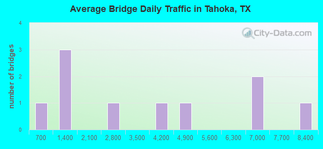
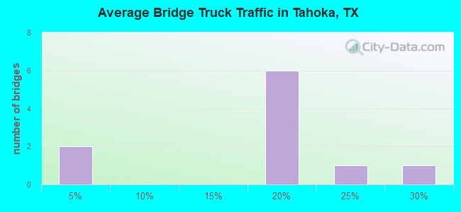
- National Bridge Inventory (NBI) Statistics
- 10Number of bridges
- 95ft / 28.7mTotal length
- 36,683Total average daily traffic
- 5,857Total average daily truck traffic
- National Bridge Inventory (NBI) Registered Bridges for Tahoka
- No street view available for this location
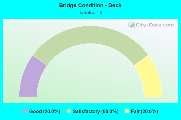
- Bridge Condition - Deck
- 20.0%Good
- 60.0%Satisfactory
- 20.0%Fair
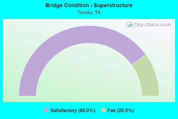
- Bridge Condition - Superstructure
- 80.0%Satisfactory
- 20.0%Fair
Find on map >> Show street view
Structure Number: 5153000680201, Location: 2.00 MI N OF US 380 (Lat: 33.194983, Lng: -101.795981), Route carried "on" structure: State highway 400, Year Built: 1968, Status: Open, Structure Length: 7.62m (25.00ft), Average Daily Traffic: 1,140 (year 2013), Truck Traffic: 18%, Average Future Daily Traffic: 1,600 (year 2033), Design Load: H 20, Features Intersected: US 87
Minimum Vertical Clearance: 30+ m (98+ ft), Kilometerpoint: 26.282, Lanes on structure: 2, Lanes under structure: 4, Owner: State Highway Agency, Approaching Roadway Width: 12.2m (40.0ft), Skew: 3 degrees, Material/Design: Prestressed concrete, Design/Construction: Stringer/Multi-beam, Number Of Spans In Main Unit: 2, Number Of Approach Spans: 2, Length of Maximum Span: 24.4m (80.1ft), Curb-To-Curb Width: 13.4m (44.0ft), Out-to-Out Width: 14.1m (46.3ft)
Condition: Deck: Good, Superstructure: Fair, Substructure: Satisfactory, Operating Rating: 54.4 metric tons, Method Used To Determine Operating Rating: Load Factor (LF), Inventory Rating: 21.8 metric tons, Method Used To Determine Inventory Rating: Load Factor (LF), Structural Evaluation: Somewhat better than minimum adequacy, Deck Geometry: Equal to present desirable criteria, Underclear: Equal to present minimum criteria, Approach Roadway Alignment: Equal to present desirable criteria, Designated Inspection Frequency: Every 24 months, Inspection Date: November 2021, Deck Structure Type: Concrete Cast-file-Place, Wearing Surface/Protective System: Wearing Surface: Bituminous
Find on map >> Show street view
Structure Number: 51530006802011, Location: 0.80 MI N OF US 380 (Lat: 33.177864, Lng: -101.794928), Route carried "on" structure: US 87, Year Built: 1968, Status: Open, Structure Length: 4.15m (13.62ft), Average Daily Traffic: 4,622 (year 2020), Truck Traffic: 16%, Average Future Daily Traffic: 5,300 (year 2033), Design Load: H 20, Features Intersected: LOOP 472
Minimum Vertical Clearance: 30+ m (98+ ft), Kilometerpoint: 24.058, Lanes on structure: 2, Lanes under structure: 2, Owner: State Highway Agency, Approaching Roadway Width: 12.2m (40.0ft), Material/Design: Prestressed concrete, Design/Construction: Stringer/Multi-beam, Number Of Spans In Main Unit: 2, Length of Maximum Span: 20.7m (67.9ft), Curb-To-Curb Width: 12.0m (39.4ft), Out-to-Out Width: 12.9m (42.3ft)
Condition: Deck: Satisfactory, Superstructure: Satisfactory, Substructure: Satisfactory, Operating Rating: 60.8 metric tons, Method Used To Determine Operating Rating: Load Factor (LF), Inventory Rating: 21.8 metric tons, Method Used To Determine Inventory Rating: Load Factor (LF), Structural Evaluation: Somewhat better than minimum adequacy, Deck Geometry: Better than present minimum criteria, Underclear: High priority of corrective action, Approach Roadway Alignment: Equal to present desirable criteria, Designated Inspection Frequency: Every 24 months, Inspection Date: November 2021, Deck Structure Type: Concrete Cast-file-Place, Wearing Surface/Protective System: Wearing Surface: Bituminous
Find on map >> Show street view
Structure Number: 51530006802012, Location: 0.80 MI N OF US 380 (Lat: 33.177794, Lng: -101.795128), Route carried "on" structure: US 87, Year Built: 1968, Status: Open, Structure Length: 4.15m (13.62ft), Average Daily Traffic: 4,181 (year 2020), Truck Traffic: 16%, Average Future Daily Traffic: 5,300 (year 2033), Design Load: H 20, Features Intersected: LOOP 472
Minimum Vertical Clearance: 30+ m (98+ ft), Kilometerpoint: 24.058, Lanes on structure: 2, Lanes under structure: 2, Owner: State Highway Agency, Approaching Roadway Width: 12.2m (40.0ft), Material/Design: Prestressed concrete, Design/Construction: Stringer/Multi-beam, Number Of Spans In Main Unit: 2, Length of Maximum Span: 20.7m (67.9ft), Curb-To-Curb Width: 12.0m (39.4ft), Out-to-Out Width: 12.8m (42.0ft)
Condition: Deck: Satisfactory, Superstructure: Satisfactory, Substructure: Satisfactory, Operating Rating: 60.8 metric tons, Method Used To Determine Operating Rating: Load Factor (LF), Inventory Rating: 21.8 metric tons, Method Used To Determine Inventory Rating: Load Factor (LF), Structural Evaluation: Somewhat better than minimum adequacy, Deck Geometry: Better than present minimum criteria, Underclear: High priority of corrective action, Approach Roadway Alignment: Equal to present desirable criteria, Designated Inspection Frequency: Every 24 months, Inspection Date: November 2021, Deck Structure Type: Concrete Cast-file-Place, Wearing Surface/Protective System: Wearing Surface: Bituminous
Find on map >> Show street view
Structure Number: 51530006802013, Location: 2.00 MI S OF FM 400 (Lat: 33.166456, Lng: -101.793839), Route carried "on" structure: US 380, Year Built: 1968, Year Reconstructed: 2002, Status: Open, Structure Length: 6.40m (21.00ft), Average Daily Traffic: 2,560 (year 2020), Truck Traffic: 25%, Average Future Daily Traffic: 2,190 (year 2033), Design Load: H 20, Features Intersected: US 87
Minimum Vertical Clearance: 30+ m (98+ ft), Kilometerpoint: 26.330, Lanes on structure: 4, Lanes under structure: 4, Owner: State Highway Agency, Approaching Roadway Width: 15.9m (52.2ft), Material/Design: Prestressed concrete, Design/Construction: Stringer/Multi-beam, Number Of Spans In Main Unit: 2, Number Of Approach Spans: 2, Length of Maximum Span: 19.8m (65.0ft), Curb or Sidewalk Widths: Left: 1.4m (4.6ft), Right: 1.4m (4.6ft), Curb-To-Curb Width: 15.8m (51.8ft), Out-to-Out Width: 19.3m (63.3ft)
Condition: Deck: Satisfactory, Superstructure: Satisfactory, Substructure: Satisfactory, Operating Rating: 54.4 metric tons, Method Used To Determine Operating Rating: Load Factor (LF), Inventory Rating: 28.1 metric tons, Method Used To Determine Inventory Rating: Load Factor (LF), Structural Evaluation: Equal to present minimum criteria, Deck Geometry: Meets minimum limits, Underclear: Equal to present minimum criteria, Approach Roadway Alignment: Equal to present desirable criteria, Designated Inspection Frequency: Every 24 months, Inspection Date: November 2021, Deck Structure Type: Concrete Cast-file-Place
Find on map >> Show street view
Structure Number: 51530006802014, Location: 1.00 MI S OF US 380 (Lat: 33.152306, Lng: -101.796631), Route carried "on" structure: State highway 472, Year Built: 1968, Status: Open, Structure Length: 6.40m (21.00ft), Average Daily Traffic: 430 (year 2013), Truck Traffic: 22%, Average Future Daily Traffic: 610 (year 2033), Design Load: H 20, Features Intersected: US 87
Minimum Vertical Clearance: 30+ m (98+ ft), Kilometerpoint: 19.005, Lanes on structure: 2, Lanes under structure: 4, Owner: State Highway Agency, Approaching Roadway Width: 9.8m (32.2ft), Material/Design: Prestressed concrete, Design/Construction: Stringer/Multi-beam, Number Of Spans In Main Unit: 2, Number Of Approach Spans: 2, Length of Maximum Span: 19.8m (65.0ft), Curb-To-Curb Width: 9.8m (32.2ft), Out-to-Out Width: 10.6m (34.8ft)
Condition: Deck: Fair, Superstructure: Satisfactory, Substructure: Satisfactory, Operating Rating: 50.8 metric tons, Method Used To Determine Operating Rating: Load Factor (LF), Inventory Rating: 27.2 metric tons, Method Used To Determine Inventory Rating: Load Factor (LF), Structural Evaluation: Equal to present minimum criteria, Deck Geometry: Equal to present minimum criteria, Underclear: Equal to present minimum criteria, Approach Roadway Alignment: Equal to present desirable criteria, Designated Inspection Frequency: Every 24 months, Inspection Date: November 2021, Deck Structure Type: Concrete Cast-file-Place
Find on map >> Show street view
Structure Number: 5153000680201, Location: 2.00 MI N OF US 380 (Lat: 33.195000, Lng: -101.796000), Route carried "under" structure: US 87, Year Built: 1968, Structure Length: 0. m, Average Daily Traffic: 8,010 (year 2013), Truck Traffic: 16%, Features Intersected: US 87, Facility Carried by Structure: FM 400
Minimum Vertical Clearance: 5.31m (17.42ft), Kilometerpoint: 22.159, Lanes on structure: 4, Material/Design: Prestressed concrete, Design/Construction: Stringer/Multi-beam, Length of Maximum Span: 24.4m (80.1ft)
Find on map >> Show street view
Structure Number: 51530006802011, Location: 0.80 MI N OF US 380 (Lat: 33.177900, Lng: -101.794900), Route carried "under" structure: Business State highway 472, Year Built: 1968, Structure Length: 0. m, Average Daily Traffic: 1,200 (year 2013), Truck Traffic: 4%, Features Intersected: LOOP 472, Facility Carried by Structure: US 87 NB
Minimum Vertical Clearance: 4.98m (16.34ft), Kilometerpoint: 16.140, Lanes on structure: 2, Material/Design: Prestressed concrete, Design/Construction: Stringer/Multi-beam, Length of Maximum Span: 20.7m (67.9ft)
Find on map >> Show street view
Structure Number: 51530006802012, Location: 0.80 MI N OF US 380 (Lat: 33.177800, Lng: -101.795100), Route carried "under" structure: Business State highway 472, Year Built: 1968, Structure Length: 0. m, Average Daily Traffic: 1,200 (year 2013), Truck Traffic: 4%, Features Intersected: LOOP 472, Facility Carried by Structure: US 87 SB
Minimum Vertical Clearance: 4.80m (15.75ft), Kilometerpoint: 16.124, Lanes on structure: 2, Material/Design: Prestressed concrete, Design/Construction: Stringer/Multi-beam, Length of Maximum Span: 20.7m (67.9ft)
Find on map >> Show street view
Structure Number: 51530006802013, Location: 2.00 MI S OF FM 400 (Lat: 33.166500, Lng: -101.793800), Route carried "under" structure: US 87, Year Built: 1968, Structure Length: 0. m, Average Daily Traffic: 6,550 (year 2013), Truck Traffic: 16%, Features Intersected: US 87, Facility Carried by Structure: US 380
Minimum Vertical Clearance: 5.11m (16.77ft), Kilometerpoint: 25.362, Lanes on structure: 4, Material/Design: Prestressed concrete, Design/Construction: Stringer/Multi-beam, Length of Maximum Span: 19.8m (65.0ft)
Find on map >> Show street view
Structure Number: 51530006802014, Location: 1.00 MI S OF US 380 (Lat: 33.152300, Lng: -101.796600), Route carried "under" structure: US 87, Year Built: 1968, Structure Length: 0. m, Average Daily Traffic: 6,790 (year 2013), Truck Traffic: 16%, Features Intersected: US 87, Facility Carried by Structure: LOOP 472
Minimum Vertical Clearance: 5.39m (17.68ft), Kilometerpoint: 26.981, Lanes on structure: 4, Material/Design: Prestressed concrete, Design/Construction: Stringer/Multi-beam, Length of Maximum Span: 19.8m (65.0ft)