Bridge Statistics for Swartzville, Pennsylvania (PA)
Condition, Traffic, Stress, Structural Evaluation, Project Costs
- National Bridge Inventory (NBI) Statistics
- 36Number of bridges
- 256ft / 78.5mTotal length
- $3,239,000Total costs
- 449,026Total average daily traffic
- 78,744Total average daily truck traffic
- National Bridge Inventory (NBI) Registered Bridges for Swartzville
- No street view available for this location
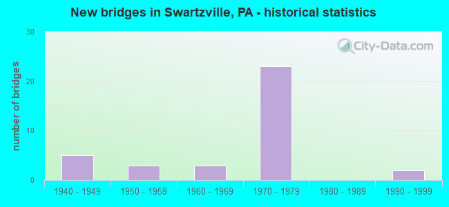
- New bridges - historical statistics
- 51940-1949
- 31950-1959
- 31960-1969
- 231970-1979
- 21990-1999

- Reconstructed bridges - Historical Statistics
- 11990-1999
- 22000-2009
- 12010-2019


- Bridge Condition - Deck
- 5.6%Very good
- 22.2%Good
- 50.0%Satisfactory
- 22.2%Fair

- Bridge Condition - Superstructure
- 5.6%Very good
- 11.1%Good
- 55.6%Satisfactory
- 27.8%Fair

- Bridge Condition - Substructure
- 50.0%Good
- 38.9%Satisfactory
- 11.1%Fair

- Bridge Condition - Channel
- 12.5%Good
- 50.0%Satisfactory
- 37.5%Fair
Find on map >> Show street view
Structure Number: 21113, Location: 2 MI. E. OF REAMSTOWN (Lat: 40.216722, Lng: -76.090539), Route carried "on" structure: US 222, Year Built: 1972, Status: Open, Structure Length: 6.86m (22.51ft), Average Daily Traffic: 18,462 (year 2022), Truck Traffic: 16%, Average Future Daily Traffic: 20,739 (year 2032), Design Load: HS 20, Features Intersected: SR 1040; SPUR ROAD
Minimum Vertical Clearance: 30+ m (98+ ft), Kilometerpoint: 73.660, Lanes on structure: 2, Lanes under structure: 4, Base Highway Network: Yes, Owner: State Highway Agency, Approaching Roadway Width: 11.9m (39.0ft), Skew: 10 degrees, Material/Design: Steel, Design/Construction: Stringer/Multi-beam, Number Of Spans In Main Unit: 1, Number Of Approach Spans: 2, Length of Maximum Span: 39.9m (130.9ft), Curb or Sidewalk Widths: Left: 0.2m (0.7ft), Right: 0.2m (0.7ft), Curb-To-Curb Width: 11.9m (39.0ft), Out-to-Out Width: 13.2m (43.3ft)
Condition: Deck: Satisfactory, Superstructure: Fair, Substructure: Satisfactory, Operating Rating: 62.6 metric tons, Method Used To Determine Operating Rating: Load Factor (LF), Inventory Rating: 37.2 metric tons, Method Used To Determine Inventory Rating: Load Factor (LF), Structural Evaluation: Somewhat better than minimum adequacy, Deck Geometry: Equal to present minimum criteria, Underclear: Better than present minimum criteria, Approach Roadway Alignment: Equal to present desirable criteria, Length Of Structure Improvement: 7.90m (25.92ft), Designated Inspection Frequency: Every 24 months, Inspection Date: May 2020, Deck Structure Type: Concrete Cast-file-Place, Wearing Surface/Protective System: Wearing Surface: Latex Concrete
Find on map >> Show street view
Structure Number: 21114, Location: 2.5 MI.E. OF REAMSTOWN (Lat: 40.218806, Lng: -76.083636), Route carried "on" structure: US 222, Year Built: 1972, Year Reconstructed: 2013, Status: Open, Structure Length: 9.36m (30.71ft), Average Daily Traffic: 18,462 (year 2022), Truck Traffic: 16%, Average Future Daily Traffic: 20,739 (year 2035), Design Load: HS 20, Features Intersected: I-76, PA TURNPIKE
Minimum Vertical Clearance: 30+ m (98+ ft), Kilometerpoint: 74.250, Lanes on structure: 2, Lanes under structure: 4, Base Highway Network: Yes, Owner: State Highway Agency, Approaching Roadway Width: 11.6m (38.1ft), Skew: 14 degrees, Material/Design: Steel, Design/Construction: Stringer/Multi-beam, Number Of Spans In Main Unit: 1, Number Of Approach Spans: 2, Length of Maximum Span: 52.1m (170.9ft), Curb or Sidewalk Widths: Left: 0.2m (0.7ft), Right: 0.2m (0.7ft), Curb-To-Curb Width: 11.9m (39.0ft), Out-to-Out Width: 13.2m (43.3ft)
Condition: Deck: Good, Superstructure: Satisfactory, Substructure: Good, Operating Rating: 76.2 metric tons, Method Used To Determine Operating Rating: Load Factor (LF), Inventory Rating: 45.4 metric tons, Method Used To Determine Inventory Rating: Load Factor (LF), Structural Evaluation: Equal to present minimum criteria, Deck Geometry: Equal to present minimum criteria, Underclear: Equal to present minimum criteria, Approach Roadway Alignment: Equal to present desirable criteria, Length Of Structure Improvement: 10.30m (33.79ft), Designated Inspection Frequency: Every 24 months, Inspection Date: January 2020, Bridge Improvement Cost: $37,000, Roadway Improvement Cost: $108,000, Total Project Cost: $495,000, Deck Structure Type: Concrete Cast-file-Place, Wearing Surface/Protective System: Wearing Surface: Latex Concrete
Find on map >> Show street view
Structure Number: 21115, Location: 0.25 mi.W. of Turnpike (Lat: 40.219731, Lng: -76.080442), Route carried "on" structure: US 222, Year Built: 1976, Status: Open, Structure Length: 3.29m (10.79ft), Average Daily Traffic: 18,462 (year 2022), Truck Traffic: 16%, Average Future Daily Traffic: 20,739 (year 2032), Design Load: HS 20, Features Intersected: SR 1059; Muddy Creek Rd
Minimum Vertical Clearance: 30+ m (98+ ft), Kilometerpoint: 74.788, Lanes on structure: 2, Lanes under structure: 2, Base Highway Network: Yes, Owner: State Highway Agency, Approaching Roadway Width: 11.6m (38.1ft), Skew: 10 degrees, Material/Design: Prestressed concrete, Design/Construction: Stringer/Multi-beam, Number Of Spans In Main Unit: 1, Length of Maximum Span: 31.4m (103.0ft), Curb or Sidewalk Widths: Left: 0.2m (0.7ft), Right: 0.2m (0.7ft), Curb-To-Curb Width: 11.9m (39.0ft), Out-to-Out Width: 13.2m (43.3ft)
Condition: Deck: Satisfactory, Superstructure: Fair, Substructure: Good, Operating Rating: 89.8 metric tons, Method Used To Determine Operating Rating: Load Factor (LF), Inventory Rating: 27.2 metric tons, Method Used To Determine Inventory Rating: Load Factor (LF), Structural Evaluation: Somewhat better than minimum adequacy, Deck Geometry: Equal to present minimum criteria, Underclear: Superior to present desirable criteria, Approach Roadway Alignment: Equal to present desirable criteria, Length Of Structure Improvement: 4.10m (13.45ft), Designated Inspection Frequency: Every 24 months, Inspection Date: May 2020, Deck Structure Type: Concrete Cast-file-Place, Wearing Surface/Protective System: Wearing Surface: Monolithic Concrete, Deck Protection: Epoxy Coated Reinforcing
Find on map >> Show street view
Structure Number: 21116, Location: 2.3 MI.E. OF REAMSTOWN (Lat: 40.218278, Lng: -76.084514), Route carried "on" structure: US 222, Year Built: 1972, Year Reconstructed: 2013, Status: Open, Structure Length: 9.42m (30.91ft), Average Daily Traffic: 18,231 (year 2022), Truck Traffic: 15%, Average Future Daily Traffic: 19,474 (year 2035), Design Load: HS 20, Features Intersected: I-76, PA TURNPIKE
Minimum Vertical Clearance: 30+ m (98+ ft), Kilometerpoint: 74.257, Lanes on structure: 2, Lanes under structure: 6, Base Highway Network: Yes, Owner: State Highway Agency, Approaching Roadway Width: 11.6m (38.1ft), Skew: 14 degrees, Material/Design: Steel, Design/Construction: Stringer/Multi-beam, Number Of Spans In Main Unit: 1, Number Of Approach Spans: 2, Length of Maximum Span: 52.1m (170.9ft), Curb or Sidewalk Widths: Left: 0.2m (0.7ft), Right: 0.2m (0.7ft), Curb-To-Curb Width: 11.9m (39.0ft), Out-to-Out Width: 13.2m (43.3ft)
Condition: Deck: Good, Superstructure: Satisfactory, Substructure: Good, Operating Rating: 76.2 metric tons, Method Used To Determine Operating Rating: Load Factor (LF), Inventory Rating: 45.4 metric tons, Method Used To Determine Inventory Rating: Load Factor (LF), Structural Evaluation: Equal to present minimum criteria, Deck Geometry: Equal to present minimum criteria, Underclear: Equal to present minimum criteria, Approach Roadway Alignment: Equal to present desirable criteria, Length Of Structure Improvement: 10.30m (33.79ft), Designated Inspection Frequency: Every 24 months, Inspection Date: January 2020, Bridge Improvement Cost: $18,000, Roadway Improvement Cost: $54,000, Total Project Cost: $246,000, Deck Structure Type: Concrete Cast-file-Place, Wearing Surface/Protective System: Wearing Surface: Latex Concrete
Find on map >> Show street view
Structure Number: 21117, Location: 0.25 MI.S. OF TURNPIKE (Lat: 40.219514, Lng: -76.080331), Route carried "on" structure: US 222, Year Built: 1976, Status: Open, Structure Length: 3.29m (10.79ft), Average Daily Traffic: 18,231 (year 2022), Truck Traffic: 15%, Average Future Daily Traffic: 19,474 (year 2032), Design Load: HS 20, Features Intersected: SR 1059; MUDDY CREEK RD
Minimum Vertical Clearance: 30+ m (98+ ft), Kilometerpoint: 74.752, Lanes on structure: 2, Lanes under structure: 2, Base Highway Network: Yes, Owner: State Highway Agency, Approaching Roadway Width: 11.6m (38.1ft), Skew: 10 degrees, Material/Design: Prestressed concrete, Design/Construction: Stringer/Multi-beam, Number Of Spans In Main Unit: 1, Length of Maximum Span: 31.4m (103.0ft), Curb or Sidewalk Widths: Left: 0.2m (0.7ft), Right: 0.2m (0.7ft), Curb-To-Curb Width: 11.9m (39.0ft), Out-to-Out Width: 13.2m (43.3ft)
Condition: Deck: Satisfactory, Superstructure: Satisfactory, Substructure: Good, Operating Rating: 89.8 metric tons, Method Used To Determine Operating Rating: Load Factor (LF), Inventory Rating: 27.2 metric tons, Method Used To Determine Inventory Rating: Load Factor (LF), Structural Evaluation: Equal to present minimum criteria, Deck Geometry: Equal to present minimum criteria, Underclear: Equal to present minimum criteria, Approach Roadway Alignment: Equal to present desirable criteria, Length Of Structure Improvement: 4.10m (13.45ft), Designated Inspection Frequency: Every 24 months, Inspection Date: May 2020, Deck Structure Type: Concrete Cast-file-Place, Wearing Surface/Protective System: Wearing Surface: Monolithic Concrete, Deck Protection: Epoxy Coated Reinforcing
Find on map >> Show street view
Structure Number: 21118, Location: 1 MI. S. OF REAMSTOWN (Lat: 40.223178, Lng: -76.067644), Route carried "on" structure: US 222, Year Built: 1975, Status: Open, Structure Length: 1.77m (5.81ft), Average Daily Traffic: 18,231 (year 2022), Truck Traffic: 15%, Average Future Daily Traffic: 19,474 (year 2032), Design Load: HS 20, Features Intersected: LITTLE MUDDY CREEK
Minimum Vertical Clearance: 30+ m (98+ ft), Kilometerpoint: 75.733, Lanes on structure: 2, Base Highway Network: Yes, Owner: State Highway Agency, Approaching Roadway Width: 11.6m (38.1ft), Skew: 12 degrees, Material/Design: Prestressed concrete, Design/Construction: Box Beam or Girders - Single/Spread, Number Of Spans In Main Unit: 1, Length of Maximum Span: 16.8m (55.1ft), Curb or Sidewalk Widths: Left: 0.2m (0.7ft), Right: 0.2m (0.7ft), Curb-To-Curb Width: 11.9m (39.0ft), Out-to-Out Width: 13.2m (43.3ft)
Condition: Deck: Satisfactory, Superstructure: Satisfactory, Substructure: Good, Channel: Satisfactory, Operating Rating: 82.6 metric tons, Method Used To Determine Operating Rating: Load Factor (LF), Inventory Rating: 33.6 metric tons, Method Used To Determine Inventory Rating: Load Factor (LF), Structural Evaluation: Equal to present minimum criteria, Deck Geometry: Equal to present minimum criteria, Waterway Adequacy: Equal to present desirable criteria, Approach Roadway Alignment: Equal to present desirable criteria, Length Of Structure Improvement: 2.50m (8.20ft), Designated Inspection Frequency: Every 24 months, Inspection Date: June 2020, Deck Structure Type: Concrete Cast-file-Place, Wearing Surface/Protective System: Wearing Surface: Monolithic Concrete, Deck Protection: Epoxy Coated Reinforcing
Find on map >> Show street view
Structure Number: 21119, Location: 3 MI. E. OF REAMSTOWN (Lat: 40.223433, Lng: -76.067597), Route carried "on" structure: US 222, Year Built: 1975, Status: Open, Structure Length: 1.74m (5.71ft), Average Daily Traffic: 18,462 (year 2022), Truck Traffic: 16%, Average Future Daily Traffic: 20,739 (year 2032), Design Load: HS 20, Features Intersected: LITTLE MUDDY CREEK
Minimum Vertical Clearance: 30+ m (98+ ft), Kilometerpoint: 75.774, Lanes on structure: 2, Base Highway Network: Yes, Owner: State Highway Agency, Approaching Roadway Width: 11.6m (38.1ft), Skew: 12 degrees, Material/Design: Prestressed concrete, Design/Construction: Box Beam or Girders - Single/Spread, Number Of Spans In Main Unit: 1, Length of Maximum Span: 17.4m (57.1ft), Curb or Sidewalk Widths: Left: 0.2m (0.7ft), Right: 0.2m (0.7ft), Curb-To-Curb Width: 11.9m (39.0ft), Out-to-Out Width: 13.2m (43.3ft)
Condition: Deck: Satisfactory, Superstructure: Fair, Substructure: Good, Channel: Satisfactory, Operating Rating: 82.6 metric tons, Method Used To Determine Operating Rating: Load Factor (LF), Inventory Rating: 33.6 metric tons, Method Used To Determine Inventory Rating: Load Factor (LF), Structural Evaluation: Somewhat better than minimum adequacy, Deck Geometry: Equal to present minimum criteria, Waterway Adequacy: Equal to present desirable criteria, Approach Roadway Alignment: Equal to present desirable criteria, Length Of Structure Improvement: 2.50m (8.20ft), Designated Inspection Frequency: Every 24 months, Inspection Date: June 2020, Deck Structure Type: Concrete Cast-file-Place, Wearing Surface/Protective System: Wearing Surface: Monolithic Concrete, Deck Protection: Epoxy Coated Reinforcing
Find on map >> Show street view
Structure Number: 21171, Location: PA 283 & L.R. 36004 (Lat: 40.242994, Lng: -76.098833), Route carried "on" structure: State highway 283, Year Built: 1969, Status: Open, Structure Length: 3.72m (12.20ft), Average Daily Traffic: 21,375 (year 2020), Truck Traffic: 16%, Average Future Daily Traffic: 31,663 (year 2032), Design Load: HS 20, Features Intersected: SR 4025; Clover Lead Rd.
Minimum Vertical Clearance: 30+ m (98+ ft), Kilometerpoint: 6.677, Lanes on structure: 2, Lanes under structure: 2, Base Highway Network: Yes, Owner: State Highway Agency, Approaching Roadway Width: 11.0m (36.1ft), Skew: 10 degrees, Material/Design: Prestressed concrete, Design/Construction: Box Beam or Girders - Single/Spread, Number Of Spans In Main Unit: 3, Length of Maximum Span: 14.0m (45.9ft), Curb or Sidewalk Widths: Left: 0.2m (0.7ft), Right: 0.2m (0.7ft), Curb-To-Curb Width: 12.2m (40.0ft), Out-to-Out Width: 13.4m (44.0ft)
Condition: Deck: Good, Superstructure: Fair, Substructure: Satisfactory, Operating Rating: 59.9 metric tons, Method Used To Determine Operating Rating: Load Factor (LF), Inventory Rating: 31.8 metric tons, Method Used To Determine Inventory Rating: Load Factor (LF), Structural Evaluation: Somewhat better than minimum adequacy, Deck Geometry: Better than present minimum criteria, Underclear: Equal to present minimum criteria, Approach Roadway Alignment: Equal to present desirable criteria, Length Of Structure Improvement: 4.70m (15.42ft), Designated Inspection Frequency: Every 24 months, Other Special Inspection Frequency: Every 6 months, Inspection Date: January 2021, Other Special Inspection Date: July 2021, Bridge Improvement Cost: $30,000, Roadway Improvement Cost: $87,000, Total Project Cost: $399,000, Deck Structure Type: Concrete Cast-file-Place, Wearing Surface/Protective System: Wearing Surface: Epoxy Overlay
Find on map >> Show street view
Structure Number: 21357, Location: 1.0 MI. SE OF SWARTZVILLE (Lat: 40.224189, Lng: -76.064375), Route carried "on" structure: State highway 897, Year Built: 1975, Status: Open, Structure Length: 7.35m (24.11ft), Average Daily Traffic: 5,561 (year 2020), Truck Traffic: 9%, Average Future Daily Traffic: 6,533 (year 2032), Design Load: HS 20, Features Intersected: US 222; SR 0222
Minimum Vertical Clearance: 30+ m (98+ ft), Kilometerpoint: 29.797, Lanes on structure: 2, Lanes under structure: 8, Owner: State Highway Agency, Approaching Roadway Width: 13.4m (44.0ft), Skew: 1 degrees, Material/Design: Steel continuous, Design/Construction: Stringer/Multi-beam, Number Of Spans In Main Unit: 2, Length of Maximum Span: 38.4m (126.0ft), Curb or Sidewalk Widths: Left: 0.2m (0.7ft), Right: 0.2m (0.7ft), Curb-To-Curb Width: 13.4m (44.0ft), Out-to-Out Width: 14.6m (47.9ft)
Condition: Deck: Satisfactory, Superstructure: Satisfactory, Substructure: Good, Operating Rating: 74.4 metric tons, Method Used To Determine Operating Rating: Load Factor (LF), Inventory Rating: 44.5 metric tons, Method Used To Determine Inventory Rating: Load Factor (LF), Structural Evaluation: Equal to present minimum criteria, Deck Geometry: Equal to present minimum criteria, Underclear: Somewhat better than minimum adequacy, Approach Roadway Alignment: Equal to present desirable criteria, Length Of Structure Improvement: 8.30m (27.23ft), Designated Inspection Frequency: Every 24 months, Inspection Date: May 2020, Deck Structure Type: Concrete Cast-file-Place, Wearing Surface/Protective System: Wearing Surface: Monolithic Concrete, Deck Protection: Epoxy Coated Reinforcing
Find on map >> Show street view
Structure Number: 21489, Location: 2MI SOF SWARTZVILLE (Lat: 40.204325, Lng: -76.082958), Route carried "on" structure: State highway , Year Built: 1951, Year Reconstructed: 2017, Status: Open, Structure Length: 2.01m (6.59ft), Average Daily Traffic: 1,888 (year 2022), Truck Traffic: 2%, Average Future Daily Traffic: 4,143 (year 2032), Design Load: HL 93, Features Intersected: LITTLE MUDDY CREEK, Facility Carried by Structure: sr 1059 muddy ck.
Minimum Vertical Clearance: 30+ m (98+ ft), Kilometerpoint: 0.000, Lanes on structure: 2, Owner: State Highway Agency, Approaching Roadway Width: 7.3m (24.0ft), Skew: 3 degrees, Material/Design: Steel continuous, Design/Construction: Stringer/Multi-beam, Number Of Spans In Main Unit: 2, Length of Maximum Span: 9.8m (32.2ft), Curb or Sidewalk Widths: Left: 0.2m (0.7ft), Right: 0.2m (0.7ft), Curb-To-Curb Width: 7.3m (24.0ft), Out-to-Out Width: 8.1m (26.6ft)
Condition: Deck: Very good, Superstructure: Very good, Substructure: Good, Channel: Satisfactory, Inventory Rating: 99.8 metric tons, Method Used To Determine Inventory Rating: Load Factor (LF), Structural Evaluation: Better than present minimum criteria, Deck Geometry: Meets minimum limits, Waterway Adequacy: Better than present minimum criteria, Approach Roadway Alignment: Equal to present desirable criteria, Length Of Structure Improvement: 2.70m (8.86ft), Designated Inspection Frequency: Every 24 months, Inspection Date: June 2020, Bridge Improvement Cost: $54,000, Roadway Improvement Cost: $158,000, Total Project Cost: $724,000, Deck Structure Type: Concrete Cast-file-Place, Wearing Surface/Protective System: Wearing Surface: Monolithic Concrete, Deck Protection: Epoxy Coated Reinforcing
Find on map >> Show street view
Structure Number: 2149, Location: TP EXIT-21 RAMP (SPUR RD) (Lat: 40.214639, Lng: -76.080117), Route carried "on" structure: State highway , Year Built: 1972, Status: Open, Structure Length: 6.43m (21.10ft), Average Daily Traffic: 1,888 (year 2022), Truck Traffic: 2%, Average Future Daily Traffic: 4,143 (year 2032), Design Load: HS 20, Features Intersected: RAMP EF (TURNPIKE), Facility Carried by Structure: 1059 Muddy Creek
Minimum Vertical Clearance: 30+ m (98+ ft), Kilometerpoint: 0.958, Lanes on structure: 2, Lanes under structure: 4, Owner: State Highway Agency, Approaching Roadway Width: 15.8m (51.8ft), Skew: 3 degrees, Material/Design: Prestressed concrete, Design/Construction: Stringer/Multi-beam, Number Of Spans In Main Unit: 1, Number Of Approach Spans: 2, Length of Maximum Span: 30.8m (101.0ft), Curb or Sidewalk Widths: Left: 0.2m (0.7ft), Right: 0.2m (0.7ft), Curb-To-Curb Width: 12.8m (42.0ft), Out-to-Out Width: 14.0m (45.9ft)
Condition: Deck: Fair, Superstructure: Good, Substructure: Fair, Operating Rating: 70.8 metric tons, Method Used To Determine Operating Rating: Load Factor (LF), Inventory Rating: 30.8 metric tons, Method Used To Determine Inventory Rating: Load Factor (LF), Structural Evaluation: Somewhat better than minimum adequacy, Deck Geometry: Better than present minimum criteria, Underclear: Superior to present desirable criteria, Approach Roadway Alignment: Equal to present desirable criteria, Length Of Structure Improvement: 7.40m (24.28ft), Designated Inspection Frequency: Every 24 months, Inspection Date: July 2020, Deck Structure Type: Concrete Cast-file-Place, Wearing Surface/Protective System: Wearing Surface: Monolithic Concrete
Find on map >> Show street view
Structure Number: 21792, Location: EAST COCALICO TWP (Lat: 40.223697, Lng: -76.095914), Route carried "on" structure: State highway 272, Year Built: 1949, Status: Open, Structure Length: 2.62m (8.60ft), Average Daily Traffic: 14,351 (year 2022), Truck Traffic: 9%, Average Future Daily Traffic: 18,085 (year 2030), Design Load: HS 20, Features Intersected: PA TPK (I-76)
Minimum Vertical Clearance: 30+ m (98+ ft), Kilometerpoint: 62.249, Lanes on structure: 3, Lanes under structure: 4, Owner: State Toll Authority, Approaching Roadway Width: 22.3m (73.2ft), Skew: 1 degrees, Material/Design: Steel, Design/Construction: Stringer/Multi-beam, Number Of Spans In Main Unit: 1, Length of Maximum Span: 25.3m (83.0ft), Curb or Sidewalk Widths: Left: 0.2m (0.7ft), Right: 0.2m (0.7ft), Curb-To-Curb Width: 19.3m (63.3ft), Out-to-Out Width: 21.9m (71.9ft)
Condition: Deck: Satisfactory, Superstructure: Satisfactory, Substructure: Satisfactory, Operating Rating: 85.3 metric tons, Method Used To Determine Operating Rating: Load Factor (LF), Inventory Rating: 50.8 metric tons, Method Used To Determine Inventory Rating: Load Factor (LF), Structural Evaluation: Equal to present minimum criteria, Deck Geometry: Superior to present desirable criteria, Underclear: High priority of corrective action, Approach Roadway Alignment: Equal to present desirable criteria, Length Of Structure Improvement: 3.40m (11.15ft), Designated Inspection Frequency: Every 24 months, Inspection Date: April 2021, Bridge Improvement Cost: $17,000, Roadway Improvement Cost: $51,000, Total Project Cost: $233,000, Deck Structure Type: Concrete Cast-file-Place, Wearing Surface/Protective System: Wearing Surface: Bituminous
Find on map >> Show street view
Structure Number: 21793, Location: EAST COCALICO TWP (Lat: 40.222019, Lng: -76.091481), Route carried "on" structure: ServiceOther road , Year Built: 1949, Year Reconstructed: 1990, Status: Open, Structure Length: 3.11m (10.20ft), Average Daily Traffic: 49 (year 1994), Truck Traffic: 6%, Average Future Daily Traffic: 76 (year 2030), Design Load: HS 20, Features Intersected: PA TPK (I-76), Facility Carried by Structure: PEPPERIDGE FARM EN
Minimum Vertical Clearance: 30+ m (98+ ft), Kilometerpoint: 0.000, Lanes on structure: 2, Lanes under structure: 4, Toll: On toll road, Owner: State Toll Authority, Approaching Roadway Width: 11.6m (38.1ft), Skew: 30 degrees, Material/Design: Steel, Design/Construction: Girder and Floorbeam System, Number Of Spans In Main Unit: 1, Length of Maximum Span: 29.9m (98.1ft), Curb or Sidewalk Widths: Left: 0.2m (0.7ft), Right: 0.2m (0.7ft), Curb-To-Curb Width: 11.0m (36.1ft), Out-to-Out Width: 13.5m (44.3ft)
Condition: Deck: Satisfactory, Superstructure: Satisfactory, Substructure: Satisfactory, Operating Rating: 57.2 metric tons, Method Used To Determine Operating Rating: Load Factor (LF), Inventory Rating: 34.5 metric tons, Method Used To Determine Inventory Rating: Load Factor (LF), Structural Evaluation: Equal to present minimum criteria, Deck Geometry: Superior to present desirable criteria, Underclear: High priority of corrective action, Approach Roadway Alignment: Better than present minimum criteria, Length Of Structure Improvement: 3.90m (12.80ft), Designated Inspection Frequency: Every 24 months, Critical Feature Inspection Frequency: Every 24 months, Inspection Date: April 2021, Critical Feature Inspection Date: April 2021, Bridge Improvement Cost: $61,000, Roadway Improvement Cost: $179,000, Total Project Cost: $822,000, Deck Structure Type: Concrete Cast-file-Place, Wearing Surface/Protective System: Wearing Surface: Latex Concrete
Find on map >> Show street view
Structure Number: 21794, Location: 1MI SOF SWARTZVILLE (Lat: 40.217447, Lng: -76.079606), Route carried "on" structure: State highway , Year Built: 1950, Status: Open, Structure Length: 3.51m (11.52ft), Average Daily Traffic: 1,888 (year 2022), Truck Traffic: 2%, Average Future Daily Traffic: 3,896 (year 2030), Design Load: HS 20, Features Intersected: PA TPK (I-76), Facility Carried by Structure: LR 36169, SR 1059
Minimum Vertical Clearance: 30+ m (98+ ft), Kilometerpoint: 1.621, Lanes on structure: 2, Lanes under structure: 4, Owner: State Toll Authority, Approaching Roadway Width: 7.3m (24.0ft), Material/Design: Steel, Design/Construction: Girder and Floorbeam System, Number Of Spans In Main Unit: 1, Length of Maximum Span: 33.5m (109.9ft), Curb or Sidewalk Widths: Left: 0.2m (0.7ft), Right: 0.2m (0.7ft), Curb-To-Curb Width: 7.3m (24.0ft), Out-to-Out Width: 8.6m (28.2ft)
Condition: Deck: Fair, Superstructure: Satisfactory, Substructure: Good, Operating Rating: 55.3 metric tons, Method Used To Determine Operating Rating: Load Factor (LF), Inventory Rating: 32.7 metric tons, Method Used To Determine Inventory Rating: Load Factor (LF), Structural Evaluation: Equal to present minimum criteria, Deck Geometry: Meets minimum limits, Underclear: High priority of corrective action, Approach Roadway Alignment: Equal to present minimum criteria, Length Of Structure Improvement: 4.40m (14.44ft), Designated Inspection Frequency: Every 24 months, Critical Feature Inspection Frequency: Every 24 months, Inspection Date: April 2021, Critical Feature Inspection Date: April 2021, Bridge Improvement Cost: $18,000, Roadway Improvement Cost: $52,000, Total Project Cost: $241,000, Deck Structure Type: Concrete Cast-file-Place, Wearing Surface/Protective System: Wearing Surface: Monolithic Concrete
Find on map >> Show street view
Structure Number: 21795, Location: EAST COCALICO TWP (Lat: 40.216331, Lng: -76.074883), Route carried "on" structure: Ramp Interstate 76, Year Built: 1970, Status: Open, Structure Length: 7.01m (23.00ft), Average Daily Traffic: 12,249 (year 1994), Truck Traffic: 16%, Average Future Daily Traffic: 18,820 (year 2030), Design Load: HS 20, Features Intersected: PA TPK (I-76), Facility Carried by Structure: RAMP AB
Minimum Vertical Clearance: 30+ m (98+ ft), Kilometerpoint: 0.000, Lanes on structure: 2, Lanes under structure: 5, Base Highway Network: Yes, Toll: On toll road, Owner: State Toll Authority, Approaching Roadway Width: 17.1m (56.1ft), Skew: 30 degrees, Material/Design: Steel, Design/Construction: Stringer/Multi-beam, Number Of Spans In Main Unit: 1, Number Of Approach Spans: 2, Length of Maximum Span: 41.8m (137.1ft), Curb or Sidewalk Widths: Left: 0.2m (0.7ft), Right: 0.2m (0.7ft), Curb-To-Curb Width: 17.1m (56.1ft), Out-to-Out Width: 18.3m (60.0ft)
Condition: Deck: Fair, Superstructure: Satisfactory, Substructure: Satisfactory, Operating Rating: 57.2 metric tons, Method Used To Determine Operating Rating: Load Factor (LF), Inventory Rating: 34.5 metric tons, Method Used To Determine Inventory Rating: Load Factor (LF), Structural Evaluation: Equal to present minimum criteria, Deck Geometry: Superior to present desirable criteria, Underclear: Meets minimum limits, Approach Roadway Alignment: Better than present minimum criteria, Length Of Structure Improvement: 7.90m (25.92ft), Designated Inspection Frequency: Every 24 months, Inspection Date: April 2021, Deck Structure Type: Concrete Cast-file-Place, Wearing Surface/Protective System: Wearing Surface: Monolithic Concrete
Find on map >> Show street view
Structure Number: 21796, Location: BRECKNOCK TWP (Lat: 40.215606, Lng: -76.071142), Route carried "on" structure: Interstate 76, Year Built: 1949, Status: Open, Structure Length: 1.74m (5.71ft), Average Daily Traffic: 33,608 (year 2001), Truck Traffic: 23%, Average Future Daily Traffic: 40,264 (year 2030), Design Load: HS 20, Features Intersected: LITTLE MUDDY CREEK
Minimum Vertical Clearance: 30+ m (98+ ft), Kilometerpoint: 0.000, Lanes on structure: 6, Base Highway Network: Yes, Toll: On toll road, Owner: State Toll Authority, Approaching Roadway Width: 23.8m (78.1ft), Skew: 32 degrees, Material/Design: Concrete, Design/Construction: Culvert, Number Of Spans In Main Unit: 1, Length of Maximum Span: 17.4m (57.1ft)
Condition: Channel: Fair, Culverts: Satisfactory, Operating Rating: 89.8 metric tons, Method Used To Determine Operating Rating: Load Factor (LF), Inventory Rating: 89.8 metric tons, Method Used To Determine Inventory Rating: Load Factor (LF), Structural Evaluation: Equal to present minimum criteria, Waterway Adequacy: Superior to present desirable criteria, Approach Roadway Alignment: Equal to present desirable criteria, Length Of Structure Improvement: 2.30m (7.55ft), Designated Inspection Frequency: Every 48 months, Inspection Date: April 2019
Find on map >> Show street view
Structure Number: 21842, Location: 3/4 MI WEST OF SR 897 (Lat: 40.216508, Lng: -76.069836), Route carried "on" structure: City street , Year Built: 1973, Status: Open, Structure Length: 1.31m (4.30ft), Average Daily Traffic: 825 (year 2012), Truck Traffic: 5%, Average Future Daily Traffic: 1,105 (year 2032), Design Load: HS 20, Features Intersected: LITTLE MUDDY CREEK, Facility Carried by Structure: T862 STONE HILL RD
Minimum Vertical Clearance: 30+ m (98+ ft), Kilometerpoint: 0.000, Lanes on structure: 2, Owner: Town or Township Highway Agency, Approaching Roadway Width: 6.4m (21.0ft), Material/Design: Prestressed concrete, Design/Construction: Box Beam or Girders - Multiple, Number Of Spans In Main Unit: 1, Length of Maximum Span: 13.1m (43.0ft), Curb or Sidewalk Widths: Left: 0.2m (0.7ft), Right: 0.2m (0.7ft), Curb-To-Curb Width: 8.5m (27.9ft), Out-to-Out Width: 9.6m (31.5ft)
Condition: Deck: Satisfactory, Superstructure: Fair, Substructure: Satisfactory, Channel: Fair, Operating Rating: 87.1 metric tons, Method Used To Determine Operating Rating: Load Factor (LF), Inventory Rating: 38.1 metric tons, Method Used To Determine Inventory Rating: Load Factor (LF), Structural Evaluation: Somewhat better than minimum adequacy, Deck Geometry: Somewhat better than minimum adequacy, Waterway Adequacy: Equal to present minimum criteria, Approach Roadway Alignment: Equal to present desirable criteria, Length Of Structure Improvement: 1.30m (4.27ft), Designated Inspection Frequency: Every 24 months, Inspection Date: March 2020, Deck Structure Type: Concrete Cast-file-Place, Wearing Surface/Protective System: Wearing Surface: Monolithic Concrete
Find on map >> Show street view
Structure Number: 21846, Location: 1300 FT WEST OF 897 (Lat: 40.220356, Lng: -76.067967), Route carried "on" structure: City street , Year Built: 1967, Status: Open, Structure Length: 0.73m (2.40ft), Average Daily Traffic: 310 (year 2012), Truck Traffic: 2%, Average Future Daily Traffic: 415 (year 2032), Features Intersected: LITTLE MUDDY CREEK, Facility Carried by Structure: T963 GEHMN SCHL RD
Minimum Vertical Clearance: 30+ m (98+ ft), Kilometerpoint: 0.000, Lanes on structure: 2, Owner: Town or Township Highway Agency, Approaching Roadway Width: 6.1m (20.0ft), Skew: 2 degrees, Material/Design: Steel, Design/Construction: Stringer/Multi-beam, Number Of Spans In Main Unit: 1, Length of Maximum Span: 7.0m (23.0ft), Curb-To-Curb Width: 6.8m (22.3ft), Out-to-Out Width: 6.9m (22.6ft)
Condition: Deck: Fair, Superstructure: Satisfactory, Substructure: Fair, Channel: Fair, Operating Rating: 64.4 metric tons, Method Used To Determine Operating Rating: Load Factor (LF), Inventory Rating: 38.1 metric tons, Method Used To Determine Inventory Rating: Load Factor (LF), Structural Evaluation: Somewhat better than minimum adequacy, Deck Geometry: Meets minimum limits, Waterway Adequacy: Equal to present minimum criteria, Approach Roadway Alignment: Somewhat better than minimum adequacy, Length Of Structure Improvement: 0.70m (2.30ft), Designated Inspection Frequency: Every 24 months, Inspection Date: March 2020, Bridge Improvement Cost: $6,000, Roadway Improvement Cost: $17,000, Total Project Cost: $79,000, Deck Structure Type: Concrete Cast-file-Place, Wearing Surface/Protective System: Wearing Surface: Bituminous
Find on map >> Show street view
Structure Number: 40473, Location: 0.75 MI. S. OF ADAMSTOWN (Lat: 40.227847, Lng: -76.066825), Route carried "on" structure: State highway 897, Year Built: 1999, Status: Open, Structure Length: 2.23m (7.32ft), Average Daily Traffic: 5,127 (year 2022), Truck Traffic: 11%, Average Future Daily Traffic: 7,539 (year 2032), Design Load: HS 25 or greater, Features Intersected: LITTLE MUDDY RUN
Minimum Vertical Clearance: 30+ m (98+ ft), Kilometerpoint: 29.797, Lanes on structure: 2, Owner: State Highway Agency, Approaching Roadway Width: 9.1m (29.9ft), Skew: 3 degrees, Material/Design: Prestressed concrete, Design/Construction: Box Beam or Girders - Multiple, Number Of Spans In Main Unit: 1, Length of Maximum Span: 21.9m (71.9ft), Curb or Sidewalk Widths: Left: 0.2m (0.7ft), Right: 0.2m (0.7ft), Curb-To-Curb Width: 10.1m (33.1ft), Out-to-Out Width: 11.1m (36.4ft)
Condition: Deck: Good, Superstructure: Good, Substructure: Satisfactory, Channel: Good, Operating Rating: 89.8 metric tons, Method Used To Determine Operating Rating: Load Factor (LF), Inventory Rating: 39.9 metric tons, Method Used To Determine Inventory Rating: Load Factor (LF), Structural Evaluation: Equal to present minimum criteria, Deck Geometry: Meets minimum limits, Waterway Adequacy: Better than present minimum criteria, Approach Roadway Alignment: Equal to present desirable criteria, Length Of Structure Improvement: 2.90m (9.51ft), Designated Inspection Frequency: Every 24 months, Inspection Date: May 2020, Wearing Surface/Protective System: Wearing Surface: Monolithic Concrete, Deck Protection: Epoxy Coated Reinforcing
Find on map >> Show street view
Structure Number: 57568, Location: NEAR HOMESTEAD RD (Lat: 40.237931, Lng: -76.087150), Route carried "on" structure: City street , Year Built: 1993, Status: Open, Structure Length: 0.98m (3.22ft), Average Daily Traffic: 100 (year 2020), Average Future Daily Traffic: 200 (year 2040), Design Load: HS 20, Features Intersected: STONY RUN, Facility Carried by Structure: MUDDY CREEK RD
Minimum Vertical Clearance: 30+ m (98+ ft), Kilometerpoint: 0.000, Lanes on structure: 2, Owner: Town or Township Highway Agency, Approaching Roadway Width: 7.0m (23.0ft), Skew: 6 degrees, Material/Design: Concrete, Design/Construction: Culvert, Number Of Spans In Main Unit: 1, Length of Maximum Span: 0.3m (1.0ft), Curb-To-Curb Width: 11.5m (37.7ft), Out-to-Out Width: 22.9m (75.1ft)
Condition: Channel: Satisfactory, Culverts: Satisfactory, Operating Rating: 66.2 metric tons, Method Used To Determine Operating Rating: Field evaluation and documented engineering judgment, Inventory Rating: 39.0 metric tons, Method Used To Determine Inventory Rating: Field evaluation and documented engineering judgment, Structural Evaluation: Equal to present minimum criteria, Deck Geometry: Superior to present desirable criteria, Waterway Adequacy: Better than present minimum criteria, Approach Roadway Alignment: Equal to present desirable criteria, Designated Inspection Frequency: Every 24 months, Inspection Date: May 2020
Find on map >> Show street view
Structure Number: 21112, Location: 2 mi. E. of Reamstown (Lat: 40.216667, Lng: -76.090000), Route carried "under" structure: Spur State highway , Year Built: 1972, Structure Length: 0. m, Average Daily Traffic: 7,939 (year 2020), Truck Traffic: 12%, Features Intersected: SR 1040; Spur Road, Facility Carried by Structure: US 222 NB; SR 0222
Minimum Vertical Clearance: 4.40m (14.44ft), Kilometerpoint: 0.000, Lanes on structure: 2, Lanes under structure: 4, Material/Design: Steel, Design/Construction: Stringer/Multi-beam, Length of Maximum Span: 39.9m (130.9ft)
Find on map >> Show street view
Structure Number: 21112, Location: 2 mi. E. of Reamstown (Lat: 40.216667, Lng: -76.090000), Route carried "under" structure: Spur State highway , Year Built: 1972, Structure Length: 0. m, Average Daily Traffic: 8,959 (year 2020), Truck Traffic: 18%, Features Intersected: SR 1040; Spur Road, Facility Carried by Structure: US 222 NB; SR 0222
Minimum Vertical Clearance: 4.98m (16.34ft), Kilometerpoint: 0.000, Lanes on structure: 2, Lanes under structure: 4, Material/Design: Steel, Design/Construction: Stringer/Multi-beam, Length of Maximum Span: 39.9m (130.9ft)
Find on map >> Show street view
Structure Number: 21113, Location: 2 MI. E. OF REAMSTOWN (Lat: 40.216722, Lng: -76.090539), Route carried "under" structure: Spur State highway , Year Built: 1972, Structure Length: 0. m, Average Daily Traffic: 7,939 (year 2020), Truck Traffic: 12%, Features Intersected: SR 1040; SPUR ROAD, Facility Carried by Structure: US 222 SB; SR 0222
Minimum Vertical Clearance: 4.88m (16.01ft), Kilometerpoint: 0.000, Lanes on structure: 2, Lanes under structure: 4, Material/Design: Steel, Design/Construction: Stringer/Multi-beam, Length of Maximum Span: 39.9m (130.9ft)
Find on map >> Show street view
Structure Number: 21113, Location: 2 MI. E. OF REAMSTOWN (Lat: 40.216722, Lng: -76.090539), Route carried "under" structure: Spur State highway , Year Built: 1972, Structure Length: 0. m, Average Daily Traffic: 8,959 (year 2020), Truck Traffic: 18%, Features Intersected: SR 1040; SPUR ROAD, Facility Carried by Structure: US 222 SB; SR 0222
Minimum Vertical Clearance: 4.88m (16.01ft), Kilometerpoint: 0.000, Lanes on structure: 2, Lanes under structure: 4, Material/Design: Steel, Design/Construction: Stringer/Multi-beam, Length of Maximum Span: 39.9m (130.9ft)
Find on map >> Show street view
Structure Number: 21114, Location: 2.5 MI.E. OF REAMSTOWN (Lat: 40.218806, Lng: -76.083636), Route carried "under" structure: Interstate 76, Year Built: 1972, Structure Length: 0. m, Average Daily Traffic: 12,000 (year 1977), Truck Traffic: 24%, Features Intersected: I-76, PA TURNPIKE, Facility Carried by Structure: US 222 SB; SR 0222
Minimum Vertical Clearance: 5.18m (16.99ft), Kilometerpoint: 0.000, Lanes on structure: 2, Lanes under structure: 2, Material/Design: Steel, Design/Construction: Stringer/Multi-beam, Length of Maximum Span: 52.1m (170.9ft)
Find on map >> Show street view
Structure Number: 21115, Location: 0.25 mi.W. of Turnpike (Lat: 40.219731, Lng: -76.080442), Route carried "under" structure: State highway , Year Built: 1976, Structure Length: 0. m, Average Daily Traffic: 1,888 (year 2022), Truck Traffic: 2%, Features Intersected: SR 1059; Muddy Creek Rd, Facility Carried by Structure: US 222 SB; SR 0222
Minimum Vertical Clearance: 5.56m (18.24ft), Kilometerpoint: 1.621, Lanes on structure: 2, Lanes under structure: 2, Material/Design: Prestressed concrete, Design/Construction: Stringer/Multi-beam, Length of Maximum Span: 31.4m (103.0ft)
Find on map >> Show street view
Structure Number: 21116, Location: 2.3 MI.E. OF REAMSTOWN (Lat: 40.218278, Lng: -76.084514), Route carried "under" structure: Interstate 76, Year Built: 1972, Structure Length: 0. m, Average Daily Traffic: 12,000 (year 1977), Truck Traffic: 24%, Features Intersected: I-76, PA TURNPIKE, Facility Carried by Structure: US 222 NB; SR 0222
Minimum Vertical Clearance: 5.21m (17.09ft), Kilometerpoint: 0.000, Lanes on structure: 2, Lanes under structure: 4, Material/Design: Steel, Design/Construction: Stringer/Multi-beam, Length of Maximum Span: 52.1m (170.9ft)
Find on map >> Show street view
Structure Number: 21117, Location: 0.25 MI.S. OF TURNPIKE (Lat: 40.219514, Lng: -76.080331), Route carried "under" structure: State highway , Year Built: 1976, Structure Length: 0. m, Average Daily Traffic: 1,888 (year 2022), Truck Traffic: 2%, Features Intersected: SR 1059; MUDDY CREEK RD, Facility Carried by Structure: US 222 NB; SR 0222
Minimum Vertical Clearance: 4.47m (14.67ft), Kilometerpoint: 1.621, Lanes on structure: 2, Lanes under structure: 2, Material/Design: Prestressed concrete, Design/Construction: Stringer/Multi-beam, Length of Maximum Span: 31.4m (103.0ft)
Find on map >> Show street view
Structure Number: 21171, Location: PA 283 & L.R. 36004 (Lat: 40.242994, Lng: -76.098833), Route carried "under" structure: State highway , Year Built: 1969, Structure Length: 0. m, Average Daily Traffic: 6,263 (year 2022), Truck Traffic: 12%, Features Intersected: SR 4025; Clover Lead Rd., Facility Carried by Structure: PA-283 EB; SR 0300
Minimum Vertical Clearance: 4.54m (14.90ft), Kilometerpoint: 1.735, Lanes on structure: 2, Lanes under structure: 2, Material/Design: Prestressed concrete, Design/Construction: Box Beam or Girders - Single/Spread, Length of Maximum Span: 14.0m (45.9ft)
Find on map >> Show street view
Structure Number: 21357, Location: 1.0 MI. SE OF SWARTZVILLE (Lat: 40.224189, Lng: -76.064375), Route carried "under" structure: US 222, Year Built: 1975, Structure Length: 0. m, Average Daily Traffic: 18,231 (year 2022), Truck Traffic: 15%, Features Intersected: US 222; SR 0222, Facility Carried by Structure: PA 897; SR 0897
Minimum Vertical Clearance: 5.26m (17.26ft), Kilometerpoint: 76.220, Lanes on structure: 2, Lanes under structure: 4, Material/Design: Steel continuous, Design/Construction: Stringer/Multi-beam, Length of Maximum Span: 38.4m (126.0ft)
Find on map >> Show street view
Structure Number: 21357, Location: 1.0 MI. SE OF SWARTZVILLE (Lat: 40.224189, Lng: -76.064375), Route carried "under" structure: US 222, Year Built: 1975, Structure Length: 0. m, Average Daily Traffic: 18,462 (year 2022), Truck Traffic: 16%, Features Intersected: US 222; SR 0222, Facility Carried by Structure: PA 897; SR 0897
Minimum Vertical Clearance: 4.50m (14.76ft), Kilometerpoint: 76.262, Lanes on structure: 2, Lanes under structure: 4, Material/Design: Steel continuous, Design/Construction: Stringer/Multi-beam, Length of Maximum Span: 38.4m (126.0ft)
Find on map >> Show street view
Structure Number: 2149, Location: TP EXIT-21 RAMP (SPUR RD) (Lat: 40.214639, Lng: -76.080117), Route carried "under" structure: Ramp Interstate 76, Year Built: 1972, Structure Length: 0. m, Average Daily Traffic: 8,217 (year 2004), Features Intersected: RAMP EF (TURNPIKE), Facility Carried by Structure: 1059 Muddy Creek
Minimum Vertical Clearance: 6.63m (21.75ft), Kilometerpoint: 0.000, Lanes on structure: 2, Lanes under structure: 4, Material/Design: Prestressed concrete, Design/Construction: Stringer/Multi-beam, Length of Maximum Span: 30.8m (101.0ft)
Find on map >> Show street view
Structure Number: 21792, Location: EAST COCALICO TWP (Lat: 40.223697, Lng: -76.095914), Route carried "under" structure: Interstate 76, Year Built: 1949, Structure Length: 0. m, Average Daily Traffic: 24,971 (year 2001), Truck Traffic: 24%, Features Intersected: PA TPK (I-76), Facility Carried by Structure: LR148,SR0272;PA272
Minimum Vertical Clearance: 5.13m (16.83ft), Kilometerpoint: 0.000, Lanes on structure: 3, Lanes under structure: 4, Material/Design: Steel, Design/Construction: Stringer/Multi-beam, Length of Maximum Span: 25.3m (83.0ft)
Find on map >> Show street view
Structure Number: 21793, Location: EAST COCALICO TWP (Lat: 40.222019, Lng: -76.091481), Route carried "under" structure: Interstate 76, Year Built: 1949, Structure Length: 0. m, Average Daily Traffic: 24,971 (year 2001), Truck Traffic: 24%, Features Intersected: PA TPK (I-76), Facility Carried by Structure: PEPPERIDGE FARM EN
Minimum Vertical Clearance: 4.60m (15.09ft), Kilometerpoint: 0.000, Lanes on structure: 2, Lanes under structure: 4, Toll: On toll road, Material/Design: Steel, Design/Construction: Girder and Floorbeam System, Length of Maximum Span: 29.9m (98.1ft)
Find on map >> Show street view
Structure Number: 21794, Location: 1MI SOF SWARTZVILLE (Lat: 40.217447, Lng: -76.079606), Route carried "under" structure: Interstate 76, Year Built: 1950, Structure Length: 0. m, Average Daily Traffic: 24,971 (year 2001), Truck Traffic: 24%, Features Intersected: PA TPK (I-76), Facility Carried by Structure: LR 36169, SR 1059
Minimum Vertical Clearance: 4.90m (16.08ft), Kilometerpoint: 0.000, Lanes on structure: 2, Lanes under structure: 4, Material/Design: Steel, Design/Construction: Girder and Floorbeam System, Length of Maximum Span: 33.5m (109.9ft)
Find on map >> Show street view
Structure Number: 21795, Location: EAST COCALICO TWP (Lat: 40.216331, Lng: -76.074883), Route carried "under" structure: Interstate 76, Year Built: 1970, Structure Length: 0. m, Average Daily Traffic: 33,608 (year 2001), Truck Traffic: 23%, Features Intersected: PA TPK (I-76), Facility Carried by Structure: RAMP AB
Minimum Vertical Clearance: 4.96m (16.27ft), Kilometerpoint: 0.000, Lanes on structure: 2, Lanes under structure: 5, Toll: On toll road, Material/Design: Steel, Design/Construction: Stringer/Multi-beam, Length of Maximum Span: 41.8m (137.1ft)