Bridge Statistics for Sunny Isles Beach, Florida (FL)
Condition, Traffic, Stress, Structural Evaluation, Project Costs
- National Bridge Inventory (NBI) Statistics
- 14Number of bridges
- 689ft / 210mTotal length
- $13,438,000Total costs
- 206,159Total average daily traffic
- 9,148Total average daily truck traffic
- National Bridge Inventory (NBI) Registered Bridges for Sunny Isles Beach
- No street view available for this location
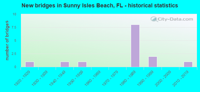
- New bridges - historical statistics
- 11920-1929
- 11940-1949
- 11950-1959
- 81980-1989
- 21990-1999
- 12010-2019


- Bridge Condition - Deck
- 25.0%Very good
- 25.0%Good
- 50.0%Satisfactory

- Bridge Condition - Superstructure
- 22.2%Very good
- 44.4%Good
- 11.1%Satisfactory
- 22.2%Fair

- Bridge Condition - Substructure
- 22.2%Very good
- 44.4%Good
- 22.2%Satisfactory
- 11.1%Fair

- Bridge Condition - Channel
- 28.6%Very good
- 14.3%Good
- 57.1%Satisfactory
Find on map >> Show street view
Structure Number: 870071, Location: 2.0M S OF NE 163 ST & A1A (Lat: 25.900064, Lng: -80.124606), Route carried "on" structure: US A1A, Year Built: 1950, Status: Open, Structure Length: 38.31m (125.69ft), Average Daily Traffic: 44,500 (year 2020), Truck Traffic: 4%, Average Future Daily Traffic: 77,208 (year 2042), Design Load: HS 20, Features Intersected: BAKERS HAULOVER INLET
Minimum Vertical Clearance: 30+ m (98+ ft), Kilometerpoint: 19.888, Lanes on structure: 4, Base Highway Network: Yes, Owner: State Highway Agency, Approaching Roadway Width: 17.3m (56.8ft), Skew: 20 degrees, Navigation Control: Yes ( Vertical Clearance: 10.6m (34.8ft), Horizontal Clearance: 3.8m (12.5ft)), Material/Design: Steel continuous, Design/Construction: Girder and Floorbeam System, Number Of Spans In Main Unit: 9, Number Of Approach Spans: 4, Length of Maximum Span: 45.7m (149.9ft), Curb or Sidewalk Widths: Left: 1.8m (5.9ft), Right: 1.8m (5.9ft), Curb-To-Curb Width: 17.1m (56.1ft), Out-to-Out Width: 21.4m (70.2ft)
Condition: Deck: Satisfactory, Superstructure: Fair, Substructure: Fair, Channel: Good, Operating Rating: 48.0 metric tons, Method Used To Determine Operating Rating: Load Factor (LF), Inventory Rating: 28.8 metric tons, Method Used To Determine Inventory Rating: Load Factor (LF), Structural Evaluation: Somewhat better than minimum adequacy, Deck Geometry: Somewhat better than minimum adequacy, Waterway Adequacy: Better than present minimum criteria, Approach Roadway Alignment: Equal to present minimum criteria, Designated Inspection Frequency: Every 24 months, Critical Feature Inspection Frequency: Every 24 months, Underwater Inspection Frequency: Every 24 months, Inspection Date: December 2021, Critical Feature Inspection Date: December 2021, Underwater Inspection Date: December 2021, Total Project Cost: $4,889,000, Deck Structure Type: Concrete Cast-file-Place, Wearing Surface/Protective System: Wearing Surface: Integral Concrete
Find on map >> Show street view
Structure Number: 870592, Location: 0.1 Mile West of A1A (Lat: 25.930253, Lng: -80.130431), Route carried "on" structure: State highway 826, Year Built: 1989, Status: Open, Structure Length: 42.61m (139.80ft), Average Daily Traffic: 17,500 (year 2021), Truck Traffic: 4%, Average Future Daily Traffic: 30,362 (year 2041), Design Load: HS 20, Features Intersected: Intracoastal Waterway
Minimum Vertical Clearance: 6.15m (20.18ft), Kilometerpoint: 0.602, Lanes on structure: 4, Lanes under structure: 1, Base Highway Network: Yes, Owner: State Highway Agency, Approaching Roadway Width: 15.8m (51.8ft), Navigation Control: Yes ( Vertical Clearance: 9.4m (30.8ft), Horizontal Clearance: 27.4m (89.9ft)), Material/Design: Steel, Design/Construction: Movable - Bascule, Number Of Spans In Main Unit: 1, Number Of Approach Spans: 15, Length of Maximum Span: 44.5m (146.0ft), Curb or Sidewalk Widths: Left: 1.8m (5.9ft), Right: 0.0m, Curb-To-Curb Width: 17.3m (56.8ft), Out-to-Out Width: 20.9m (68.6ft)
Condition: Deck: Satisfactory, Superstructure: Good, Substructure: Good, Channel: Satisfactory, Operating Rating: 39.6 metric tons, Method Used To Determine Operating Rating: Load Factor (LF), Inventory Rating: 23.6 metric tons, Method Used To Determine Inventory Rating: Load Factor (LF), Structural Evaluation: Somewhat better than minimum adequacy, Deck Geometry: Meets minimum limits, Underclear: Superior to present desirable criteria, Waterway Adequacy: Equal to present desirable criteria, Approach Roadway Alignment: Better than present minimum criteria, Length Of Structure Improvement: 43.16m (141.60ft), Designated Inspection Frequency: Every 24 months, Critical Feature Inspection Frequency: Every 24 months, Underwater Inspection Frequency: Every 24 months, Other Special Inspection Frequency: Every 12 months, Inspection Date: October 2020, Critical Feature Inspection Date: October 2020, Underwater Inspection Date: October 2020, Other Special Inspection Date: October 2021, Bridge Improvement Cost: $500,000, Total Project Cost: $3,889,000, Deck Structure Type: Concrete Cast-file-Place, Wearing Surface/Protective System: Wearing Surface: Monolithic Concrete, Deck Protection: Epoxy Coated Reinforcing
Find on map >> Show street view
Structure Number: 870593, Location: 0.1 Mile West of A1A (Lat: 25.929792, Lng: -80.130153), Route carried "on" structure: State highway 826, Year Built: 1989, Status: Open, Structure Length: 42.61m (139.80ft), Average Daily Traffic: 20,000 (year 2021), Truck Traffic: 4%, Average Future Daily Traffic: 34,700 (year 2041), Design Load: HS 20, Features Intersected: Intracoastal Waterway
Minimum Vertical Clearance: 6.12m (20.08ft), Kilometerpoint: 8.216, Lanes on structure: 4, Lanes under structure: 3, Base Highway Network: Yes, Owner: State Highway Agency, Approaching Roadway Width: 15.8m (51.8ft), Navigation Control: Yes ( Vertical Clearance: 9.4m (30.8ft), Horizontal Clearance: 27.4m (89.9ft)), Material/Design: Steel, Design/Construction: Movable - Bascule, Number Of Spans In Main Unit: 1, Number Of Approach Spans: 15, Length of Maximum Span: 44.5m (146.0ft), Curb or Sidewalk Widths: Left: 0.0m, Right: 1.8m (5.9ft), Curb-To-Curb Width: 17.3m (56.8ft), Out-to-Out Width: 20.0m (65.6ft)
Condition: Deck: Satisfactory, Superstructure: Good, Substructure: Good, Channel: Satisfactory, Operating Rating: 41.6 metric tons, Method Used To Determine Operating Rating: Load Factor (LF), Inventory Rating: 24.9 metric tons, Method Used To Determine Inventory Rating: Load Factor (LF), Structural Evaluation: Equal to present minimum criteria, Deck Geometry: Meets minimum limits, Underclear: Superior to present desirable criteria, Waterway Adequacy: Equal to present desirable criteria, Approach Roadway Alignment: Somewhat better than minimum adequacy, Length Of Structure Improvement: 43.16m (141.60ft), Designated Inspection Frequency: Every 24 months, Critical Feature Inspection Frequency: Every 24 months, Underwater Inspection Frequency: Every 24 months, Other Special Inspection Frequency: Every 12 months, Inspection Date: October 2020, Critical Feature Inspection Date: October 2020, Underwater Inspection Date: October 2020, Other Special Inspection Date: October 2021, Bridge Improvement Cost: $500,000, Total Project Cost: $3,889,000, Deck Structure Type: Concrete Cast-file-Place, Wearing Surface/Protective System: Wearing Surface: Monolithic Concrete, Deck Protection: Epoxy Coated Reinforcing
Find on map >> Show street view
Structure Number: 870603, Location: 0.1M W OF A1A (Lat: 25.953508, Lng: -80.120803), Route carried "on" structure: State highway 856, Year Built: 1981, Status: Open, Structure Length: 41.70m (136.81ft), Average Daily Traffic: 18,500 (year 2020), Truck Traffic: 3%, Average Future Daily Traffic: 32,098 (year 2042), Design Load: HL 93, Features Intersected: SR A1A TO SR 856 N TO W
Minimum Vertical Clearance: 30+ m (98+ ft), Kilometerpoint: 0.140, Lanes on structure: 2, Lanes under structure: 4, Owner: State Highway Agency, Approaching Roadway Width: 12.4m (40.7ft), Material/Design: Steel continuous, Design/Construction: Stringer/Multi-beam, Number Of Spans In Main Unit: 5, Number Of Approach Spans: 8, Length of Maximum Span: 41.6m (136.5ft), Curb-To-Curb Width: 12.2m (40.0ft), Out-to-Out Width: 13.0m (42.7ft)
Condition: Deck: Good, Superstructure: Good, Substructure: Good, Operating Rating: 48.4 metric tons, Method Used To Determine Operating Rating: Load and Resistance Factor (LRFR), Inventory Rating: 35.6 metric tons, Method Used To Determine Inventory Rating: Load and Resistance Factor (LRFR), Structural Evaluation: Better than present minimum criteria, Deck Geometry: Better than present minimum criteria, Underclear: Equal to present minimum criteria, Approach Roadway Alignment: Equal to present desirable criteria, Designated Inspection Frequency: Every 24 months, Inspection Date: January 2021, Deck Structure Type: Concrete Cast-file-Place, Wearing Surface/Protective System: Wearing Surface: Monolithic Concrete
Find on map >> Show street view
Structure Number: 870706, Location: SR-A1A NB TO SR-826 WB (Lat: 25.930314, Lng: -80.122317), Route carried "on" structure: Alternate State highway A1A, Year Built: 1989, Status: Open, Structure Length: 33.22m (108.99ft), Average Daily Traffic: 8,500 (year 2020), Truck Traffic: 3%, Average Future Daily Traffic: 14,748 (year 2042), Design Load: HL 93, Features Intersected: SR - A1A SB, Facility Carried by Structure: RAMP SR-826
Minimum Vertical Clearance: 30+ m (98+ ft), Kilometerpoint: 0.111, Lanes on structure: 2, Lanes under structure: 8, Owner: State Highway Agency, Approaching Roadway Width: 11.6m (38.1ft), Material/Design: Steel, Design/Construction: Stringer/Multi-beam, Number Of Spans In Main Unit: 5, Number Of Approach Spans: 2, Length of Maximum Span: 60.0m (196.9ft), Curb-To-Curb Width: 11.6m (38.1ft), Out-to-Out Width: 12.4m (40.7ft)
Condition: Deck: Good, Superstructure: Good, Substructure: Good, Operating Rating: 51.9 metric tons, Method Used To Determine Operating Rating: Load and Resistance Factor (LRFR), Inventory Rating: 40.2 metric tons, Method Used To Determine Inventory Rating: Load and Resistance Factor (LRFR), Structural Evaluation: Better than present minimum criteria, Deck Geometry: Better than present minimum criteria, Underclear: Somewhat better than minimum adequacy, Approach Roadway Alignment: Meets minimum limits, Length Of Structure Improvement: 10.13m (33.23ft), Designated Inspection Frequency: Every 24 months, Inspection Date: May 2021, Bridge Improvement Cost: $450,000, Total Project Cost: $700,000, Deck Structure Type: Concrete Cast-file-Place, Wearing Surface/Protective System: Wearing Surface: Monolithic Concrete
Find on map >> Show street view
Structure Number: 870712, Location: .25 M E OF US1 ON SR-826 (Lat: 25.926056, Lng: -80.149444), Route carried "on" structure: State highway 826, Year Built: 1942, Year Reconstructed: 1985, Status: Open, Structure Length: 6.40m (21.00ft), Average Daily Traffic: 59,500 (year 2018), Truck Traffic: 6%, Average Future Daily Traffic: 103,232 (year 2040), Design Load: HS 20, Features Intersected: OLETA RIVER
Minimum Vertical Clearance: 30+ m (98+ ft), Kilometerpoint: 6.365, Lanes on structure: 8, Owner: State Highway Agency, Approaching Roadway Width: 37.5m (123.0ft), Skew: 20 degrees, Material/Design: Concrete, Design/Construction: Tee Beam, Number Of Spans In Main Unit: 7, Length of Maximum Span: 9.1m (29.9ft), Curb or Sidewalk Widths: Left: 2.5m (8.2ft), Right: 0.0m, Curb-To-Curb Width: 37.4m (122.7ft), Out-to-Out Width: 40.8m (133.9ft)
Condition: Deck: Satisfactory, Superstructure: Satisfactory, Substructure: Satisfactory, Channel: Very good, Operating Rating: 64.9 metric tons, Method Used To Determine Operating Rating: Load Factor (LF), Inventory Rating: 38.9 metric tons, Method Used To Determine Inventory Rating: Load Factor (LF), Structural Evaluation: Equal to present minimum criteria, Deck Geometry: Superior to present desirable criteria, Waterway Adequacy: Better than present minimum criteria, Approach Roadway Alignment: Equal to present desirable criteria, Designated Inspection Frequency: Every 24 months, Underwater Inspection Frequency: Every 24 months, Inspection Date: September 2021, Underwater Inspection Date: September 2021, Deck Structure Type: Concrete Cast-file-Place, Wearing Surface/Protective System: Wearing Surface: Bituminous
Find on map >> Show street view
Structure Number: 87421, Location: 80 ft. W/O A1A (Lat: 25.927072, Lng: -80.122642), Route carried "on" structure: County highway , Year Built: 1993, Status: Open, Structure Length: 1.55m (5.09ft), Average Daily Traffic: 100 (year 2020), Average Future Daily Traffic: 153 (year 2042), Design Load: HS 20, Features Intersected: Ocean Canal, Facility Carried by Structure: Atlantic Avenue
Minimum Vertical Clearance: 30+ m (98+ ft), Kilometerpoint: 0.066, Lanes on structure: 2, Owner: City or Municipal Highway Agency, Approaching Roadway Width: 9.0m (29.5ft), Material/Design: Prestressed concrete, Design/Construction: Stringer/Multi-beam, Number Of Spans In Main Unit: 1, Length of Maximum Span: 15.5m (50.9ft), Curb or Sidewalk Widths: Left: 0.0m, Right: 1.5m (4.9ft), Curb-To-Curb Width: 8.2m (26.9ft), Out-to-Out Width: 11.4m (37.4ft)
Condition: Deck: Very good, Superstructure: Very good, Substructure: Very good, Channel: Satisfactory, Operating Rating: 67.5 metric tons, Method Used To Determine Operating Rating: Load Factor (LF), Inventory Rating: 36.2 metric tons, Method Used To Determine Inventory Rating: Load Factor (LF), Structural Evaluation: Equal to present desirable criteria, Deck Geometry: Equal to present minimum criteria, Waterway Adequacy: Better than present minimum criteria, Approach Roadway Alignment: Equal to present desirable criteria, Designated Inspection Frequency: Every 24 months, Underwater Inspection Frequency: Every 24 months, Inspection Date: October 2020, Underwater Inspection Date: October 2020, Deck Structure Type: Concrete Cast-file-Place, Wearing Surface/Protective System: Wearing Surface: Monolithic Concrete
Find on map >> Show street view
Structure Number: 874218, Location: 0.25 Mile West of A1A (Lat: 25.927456, Lng: -80.126133), Route carried "on" structure: City street , Year Built: 1925, Status: Posted for load, Structure Length: 1.31m (4.30ft), Average Daily Traffic: 109 (year 2015), Average Future Daily Traffic: 657 (year 2037), Design Load: HS 20, Features Intersected: Ocean Canal, Facility Carried by Structure: Atlantic Isle Ave.
Minimum Vertical Clearance: 30+ m (98+ ft), Kilometerpoint: 0.410, Lanes on structure: 1, Owner: City or Municipal Highway Agency, Approaching Roadway Width: 5.3m (17.4ft), Material/Design: Concrete, Design/Construction: Arch - Deck, Number Of Spans In Main Unit: 1, Length of Maximum Span: 13.1m (43.0ft), Curb-To-Curb Width: 3.0m (9.8ft), Out-to-Out Width: 6.2m (20.3ft)
Condition: Superstructure: Fair, Substructure: Satisfactory, Channel: Very good, Operating Rating: 16.8 metric tons, Method Used To Determine Operating Rating: Allowable Stress (AS), Inventory Rating: 13.3 metric tons, Method Used To Determine Inventory Rating: Allowable Stress (AS), Structural Evaluation: Meets minimum limits, Deck Geometry: High priority of replacement, Waterway Adequacy: Better than present minimum criteria, Approach Roadway Alignment: Somewhat better than minimum adequacy, Bridge Posting: Required (Relationship of Operating Rating to Maximum Legal Load: > 39.9% below), Designated Inspection Frequency: Every 24 months, Other Special Inspection Frequency: Every 12 months, Inspection Date: September 2021, Other Special Inspection Date: September 2021, Bridge Improvement Cost: $43,000, Roadway Improvement Cost: $5,000, Total Project Cost: $71,000, Wearing Surface/Protective System: Wearing Surface: Bituminous
Find on map >> Show street view
Structure Number: 874219, Location: 200 ft. W/O A1A (Lat: 25.927100, Lng: -80.123014), Route carried "on" structure: County highway , Year Built: 1993, Status: Open, Structure Length: 1.90m (6.23ft), Average Daily Traffic: 100 (year 2014), Average Future Daily Traffic: 153 (year 2036), Design Load: HS 20, Features Intersected: Ocean Canal, Facility Carried by Structure: Atlantic Avenue
Minimum Vertical Clearance: 30+ m (98+ ft), Kilometerpoint: 0.029, Lanes on structure: 2, Owner: City or Municipal Highway Agency, Approaching Roadway Width: 8.8m (28.9ft), Material/Design: Prestressed concrete, Design/Construction: Stringer/Multi-beam, Number Of Spans In Main Unit: 1, Length of Maximum Span: 19.0m (62.3ft), Curb or Sidewalk Widths: Left: 0.0m, Right: 1.5m (4.9ft), Curb-To-Curb Width: 8.8m (28.9ft), Out-to-Out Width: 12.0m (39.4ft)
Condition: Deck: Very good, Superstructure: Very good, Substructure: Very good, Channel: Satisfactory, Operating Rating: 79.8 metric tons, Method Used To Determine Operating Rating: Load Factor (LF), Inventory Rating: 34.5 metric tons, Method Used To Determine Inventory Rating: Load Factor (LF), Structural Evaluation: Equal to present desirable criteria, Deck Geometry: Better than present minimum criteria, Waterway Adequacy: Better than present minimum criteria, Approach Roadway Alignment: Equal to present desirable criteria, Designated Inspection Frequency: Every 24 months, Underwater Inspection Frequency: Every 24 months, Inspection Date: October 2020, Underwater Inspection Date: October 2020, Deck Structure Type: Concrete Cast-file-Place
Find on map >> Show street view
Structure Number: 870592, Location: 0.1 Mile West of A1A (Lat: 25.930253, Lng: -80.130431), Route carried "under" structure: ServiceCity street , Year Built: 1989, Structure Length: 0. m, Average Daily Traffic: 300 (year 2021), Truck Traffic: 3%, Features Intersected: Intracoastal Waterway, Facility Carried by Structure: SR-826 WB
Minimum Vertical Clearance: 5.12m (16.80ft), Kilometerpoint: 0.000, Lanes on structure: 4, Lanes under structure: 1, Material/Design: Steel, Design/Construction: Movable - Bascule, Length of Maximum Span: 44.5m (146.0ft)
Find on map >> Show street view
Structure Number: 870593, Location: 0.1 Mile West of A1A (Lat: 25.929792, Lng: -80.130153), Route carried "under" structure: ServiceCity street , Year Built: 1989, Structure Length: 0. m, Average Daily Traffic: 300 (year 2021), Truck Traffic: 3%, Features Intersected: Intracoastal Waterway, Facility Carried by Structure: SR-826 EB
Minimum Vertical Clearance: 5.85m (19.19ft), Kilometerpoint: 0.000, Lanes on structure: 4, Lanes under structure: 1, Material/Design: Steel, Design/Construction: Movable - Bascule, Length of Maximum Span: 44.5m (146.0ft)
Find on map >> Show street view
Structure Number: 870603, Location: 0.1M W OF A1A (Lat: 25.953508, Lng: -80.120803), Route carried "under" structure: State highway 856, Year Built: 1981, Structure Length: 0. m, Average Daily Traffic: 16,750 (year 2020), Truck Traffic: 4%, Features Intersected: SR A1A TO SR 856 N TO W
Minimum Vertical Clearance: 30+ m (98+ ft), Kilometerpoint: 2.691, Lanes on structure: 2, Lanes under structure: 4, Material/Design: Steel continuous, Design/Construction: Stringer/Multi-beam, Length of Maximum Span: 41.6m (136.5ft)
Find on map >> Show street view
Structure Number: 870706, Location: SR-A1A NB TO SR-826 WB (Lat: 25.930314, Lng: -80.122317), Route carried "under" structure: Ramp State highway 826, Year Built: 1989, Structure Length: 0. m, Average Daily Traffic: 20,000 (year 2020), Truck Traffic: 4%, Features Intersected: SR - A1A SB
Minimum Vertical Clearance: 30+ m (98+ ft), Kilometerpoint: 9.194, Lanes on structure: 2, Lanes under structure: 8, Material/Design: Steel, Design/Construction: Stringer/Multi-beam, Length of Maximum Span: 60.0m (196.9ft)
Find on map >> Show street view
Structure Number: 87909, Location: SR826 0.1M OF N.Bay Rd. (Lat: 25.930572, Lng: -80.125003), Route carried "under" structure: State highway 826, Year Built: 2017, Structure Length: 0. m, Features Intersected: N. Bay Rd.
Minimum Vertical Clearance: 5.49m (18.01ft), Kilometerpoint: 24.124, Lanes under structure: 5, Material/Design: Steel continuous, Design/Construction: Truss - Thru, Length of Maximum Span: 32.0m (105.0ft)