Bridge Statistics for Sunfield, Michigan (MI)
Condition, Traffic, Stress, Structural Evaluation, Project Costs
- National Bridge Inventory (NBI) Statistics
- 16Number of bridges
- 66ft / 20.3mTotal length
- $703,582,000Total costs
- 17,150Total average daily traffic
- 1,715Total average daily truck traffic
- 21,173Total future (year 2013) average daily traffic
- National Bridge Inventory (NBI) Registered Bridges for Sunfield
- No street view available for this location
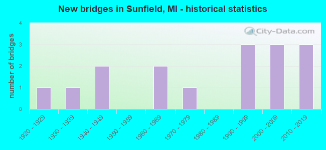
- New bridges - historical statistics
- 11920-1929
- 11930-1939
- 21940-1949
- 21960-1969
- 11970-1979
- 31990-1999
- 32000-2009
- 32010-2019

- Reconstructed bridges - Historical Statistics
- 11980-1989
- 11990-1999


- Bridge Condition - Deck
- 33.3%Very good
- 16.7%Good
- 33.3%Satisfactory
- 16.7%Fair

- Bridge Condition - Superstructure
- 25.0%Very good
- 33.3%Good
- 16.7%Satisfactory
- 16.7%Fair
- 8.3%Serious

- Bridge Condition - Substructure
- 41.7%Very good
- 8.3%Good
- 33.3%Satisfactory
- 8.3%Fair
- 8.3%Poor

- Bridge Condition - Channel
- 6.3%Excellent
- 18.8%Very good
- 31.3%Good
- 25.0%Satisfactory
- 18.8%Fair

- Bridge Condition - Culverts
- 25.0%Very good
- 25.0%Good
- 25.0%Satisfactory
- 25.0%Fair
Find on map >> Show street view
Structure Number: 2225, Location: 2.3 MI W OF SUNFIELD (Lat: 42.755917, Lng: -85.041797), Route carried "on" structure: State highway 43, Year Built: 1949, Status: Open, Structure Length: 1.06m (3.48ft), Average Daily Traffic: 3,660 (year 2007), Truck Traffic: 8%, Average Future Daily Traffic: 4,186 (year 2018), Design Load: HS 20, Features Intersected: MUD CREEK
Minimum Vertical Clearance: 30.48m (100.00ft), Kilometerpoint: 0.581, Lanes on structure: 2, Base Highway Network: Yes (Inventory Route: 56, Subroute: 3), Owner: State Highway Agency, Approaching Roadway Width: 12.5m (41.0ft), Skew: 3 degrees, Material/Design: Steel, Design/Construction: Stringer/Multi-beam, Number Of Spans In Main Unit: 1, Length of Maximum Span: 10.6m (34.8ft), Curb or Sidewalk Widths: Left: 0.4m (1.3ft), Right: 0.4m (1.3ft), Curb-To-Curb Width: 11.5m (37.7ft), Out-to-Out Width: 13.3m (43.6ft)
Condition: Deck: Satisfactory, Superstructure: Fair, Substructure: Satisfactory, Channel: Satisfactory, Operating Rating: 68.7 metric tons, Method Used To Determine Operating Rating: Load Factor (LF), Inventory Rating: 41.1 metric tons, Method Used To Determine Inventory Rating: Load Factor (LF), Structural Evaluation: Somewhat better than minimum adequacy, Deck Geometry: Somewhat better than minimum adequacy, Waterway Adequacy: Better than present minimum criteria, Approach Roadway Alignment: Equal to present desirable criteria, Length Of Structure Improvement: 1.07m (3.51ft), Designated Inspection Frequency: Every 24 months, Inspection Date: April 2021, Bridge Improvement Cost: $20,000, Roadway Improvement Cost: $2,000, Total Project Cost: $23,000, Deck Structure Type: Concrete Cast-file-Place, Wearing Surface/Protective System: Wearing Surface: Bituminous
Find on map >> Show street view
Structure Number: 2226, Location: 2.0 MI E OF SUNFIELD (Lat: 42.755633, Lng: -84.957222), Route carried "on" structure: State highway 43, Year Built: 1949, Year Reconstructed: 2004, Status: Open, Structure Length: 1.12m (3.67ft), Average Daily Traffic: 4,192 (year 2007), Truck Traffic: 8%, Average Future Daily Traffic: 4,592 (year 2018), Design Load: HS 25 or greater, Features Intersected: SEBEWA DRAIN
Minimum Vertical Clearance: 30.48m (100.00ft), Kilometerpoint: 7.503, Lanes on structure: 2, Base Highway Network: Yes (Inventory Route: 56, Subroute: 3), Owner: State Highway Agency, Approaching Roadway Width: 13.4m (44.0ft), Material/Design: Prestressed concrete, Design/Construction: Box Beam or Girders - Single/Spread, Number Of Spans In Main Unit: 1, Length of Maximum Span: 9.8m (32.2ft), Curb-To-Curb Width: 13.4m (44.0ft), Out-to-Out Width: 14.2m (46.6ft)
Condition: Deck: Satisfactory, Superstructure: Very good, Substructure: Satisfactory, Channel: Satisfactory, Operating Rating: 75.5 metric tons, Method Used To Determine Operating Rating: Load Factor (LF), Inventory Rating: 38.5 metric tons, Method Used To Determine Inventory Rating: Load Factor (LF), Structural Evaluation: Equal to present minimum criteria, Deck Geometry: Better than present minimum criteria, Waterway Adequacy: Better than present minimum criteria, Approach Roadway Alignment: Equal to present desirable criteria, Length Of Structure Improvement: 1.07m (3.51ft), Designated Inspection Frequency: Every 24 months, Inspection Date: April 2021, Bridge Improvement Cost: $34,000, Roadway Improvement Cost: $2,000, Total Project Cost: $23,000, Deck Structure Type: Concrete Cast-file-Place, Wearing Surface/Protective System: Wearing Surface: Monolithic Concrete, Deck Protection: Other Coated Reinforcing
Find on map >> Show street view
Structure Number: 2231, Location: 5.5 MI SE OF BARRY COL (Lat: 42.716231, Lng: -84.990603), Route carried "on" structure: State highway 50, Year Built: 1934, Status: Open, Structure Length: 0.79m (2.59ft), Average Daily Traffic: 2,443 (year 2007), Truck Traffic: 16%, Average Future Daily Traffic: 3,460 (year 2018), Design Load: H 15, Features Intersected: SEBEWA DRAIN
Minimum Vertical Clearance: 30.48m (100.00ft), Kilometerpoint: 8.607, Lanes on structure: 2, Base Highway Network: Yes (Inventory Route: 56, Subroute: 4), Owner: State Highway Agency, Approaching Roadway Width: 11.3m (37.1ft), Material/Design: Concrete, Design/Construction: Tee Beam, Number Of Spans In Main Unit: 1, Length of Maximum Span: 7.9m (25.9ft), Curb-To-Curb Width: 14.3m (46.9ft), Out-to-Out Width: 14.9m (48.9ft)
Condition: Deck: Satisfactory, Superstructure: Satisfactory, Substructure: Good, Channel: Good, Operating Rating: 52.2 metric tons, Method Used To Determine Operating Rating: Load Factor (LF) rating reported by rating factor (RF) method using MS18 loading, Inventory Rating: 31.4 metric tons, Method Used To Determine Inventory Rating: Load Factor (LF) rating reported by rating factor (RF) method using MS18 loading, Structural Evaluation: Equal to present minimum criteria, Deck Geometry: Superior to present desirable criteria, Waterway Adequacy: Equal to present desirable criteria, Approach Roadway Alignment: Equal to present desirable criteria, Designated Inspection Frequency: Every 24 months, Inspection Date: June 2021, Deck Structure Type: Concrete Cast-file-Place, Wearing Surface/Protective System: Wearing Surface: Bituminous
Find on map >> Show street view
Structure Number: 2232, Location: 0.3 MI SE OF M-43 (Lat: 42.752311, Lng: -85.043803), Route carried "on" structure: State highway 50, Year Built: 2013, Status: Open, Structure Length: 1.31m (4.30ft), Average Daily Traffic: 2,842 (year 2013), Truck Traffic: 17%, Average Future Daily Traffic: 3,350 (year 2033), Design Load: Greater than HL93, Features Intersected: MUD CREEK
Minimum Vertical Clearance: 30.48m (100.00ft), Kilometerpoint: 2.668, Lanes on structure: 2, Base Highway Network: Yes (Inventory Route: 56, Subroute: 4), Owner: State Highway Agency, Approaching Roadway Width: 12.2m (40.0ft), Skew: 2 degrees, Material/Design: Concrete, Design/Construction: Culvert, Number Of Spans In Main Unit: 1, Length of Maximum Span: 10.8m (35.4ft), Curb-To-Curb Width: 12.2m (40.0ft), Out-to-Out Width: 14.7m (48.2ft)
Condition: Channel: Excellent, Culverts: Good, Operating Rating: 52.2 metric tons, Method Used To Determine Operating Rating: Load and Resistance Factor Rating (LRFR) rating reported by rating factor(RF) method using HL-93 loadings, Inventory Rating: 40.2 metric tons, Method Used To Determine Inventory Rating: Load and Resistance Factor Rating (LRFR) rating reported by rating factor(RF) method using HL-93 loadings, Structural Evaluation: Better than present minimum criteria, Deck Geometry: Equal to present minimum criteria, Waterway Adequacy: Equal to present desirable criteria, Approach Roadway Alignment: Equal to present desirable criteria, Designated Inspection Frequency: Every 24 months, Inspection Date: June 2021
Find on map >> Show street view
Structure Number: 2351, Location: 2 MI E OF SUNFIELD (Lat: 42.750144, Lng: -84.957403), Route carried "on" structure: County highway , Year Built: 2003, Status: Open, Structure Length: 1.62m (5.31ft), Average Daily Traffic: 721 (year 2012), Average Future Daily Traffic: 1,150 (year 2021), Design Load: HS 20, Features Intersected: SEBEWA CREEK, Facility Carried by Structure: DOW ROAD
Minimum Vertical Clearance: 30.48m (100.00ft), Kilometerpoint: 8.021, Lanes on structure: 2, Owner: County Highway Agency, Approaching Roadway Width: 9.1m (29.9ft), Material/Design: Prestressed concrete, Design/Construction: Box Beam or Girders - Multiple, Number Of Spans In Main Unit: 1, Length of Maximum Span: 15.5m (50.9ft), Curb-To-Curb Width: 10.4m (34.1ft), Out-to-Out Width: 11.4m (37.4ft)
Condition: Deck: Very good, Superstructure: Very good, Substructure: Very good, Channel: Very good, Operating Rating: 97.2 metric tons, Method Used To Determine Operating Rating: Load Factor (LF) rating reported by rating factor (RF) method using MS18 loading, Inventory Rating: 61.9 metric tons, Method Used To Determine Inventory Rating: Load Factor (LF) rating reported by rating factor (RF) method using MS18 loading, Structural Evaluation: Equal to present desirable criteria, Deck Geometry: Equal to present minimum criteria, Waterway Adequacy: Equal to present desirable criteria, Approach Roadway Alignment: Equal to present minimum criteria, Designated Inspection Frequency: Every 24 months, Inspection Date: April 2021, Deck Structure Type: Concrete Precast Panels, Wearing Surface/Protective System: Wearing Surface: Bituminous, Membrane: Preformed Fabric
Find on map >> Show street view
Structure Number: 2408, Location: 3 MI W OF MULLIKEN (Lat: 42.770461, Lng: -84.951267), Route carried "on" structure: County highway , Year Built: 1993, Status: Open, Structure Length: 1.52m (4.99ft), Average Daily Traffic: 120 (year 2011), Average Future Daily Traffic: 240 (year 2014), Design Load: HS 20, Features Intersected: SABEWA CREEK, Facility Carried by Structure: EATON HWY
Minimum Vertical Clearance: 30.48m (100.00ft), Kilometerpoint: 10.062, Lanes on structure: 2, Owner: County Highway Agency, Approaching Roadway Width: 9.1m (29.9ft), Material/Design: Prestressed concrete, Design/Construction: Box Beam or Girders - Multiple, Number Of Spans In Main Unit: 1, Length of Maximum Span: 14.6m (47.9ft), Curb-To-Curb Width: 9.1m (29.9ft), Out-to-Out Width: 9.5m (31.2ft)
Condition: Deck: Good, Superstructure: Good, Substructure: Very good, Channel: Very good, Operating Rating: 56.4 metric tons, Method Used To Determine Operating Rating: Load Factor (LF) rating reported by rating factor (RF) method using MS18 loading, Inventory Rating: 33.7 metric tons, Method Used To Determine Inventory Rating: Load Factor (LF) rating reported by rating factor (RF) method using MS18 loading, Structural Evaluation: Better than present minimum criteria, Deck Geometry: Equal to present minimum criteria, Waterway Adequacy: Equal to present desirable criteria, Approach Roadway Alignment: Equal to present desirable criteria, Designated Inspection Frequency: Every 24 months, Inspection Date: April 2021, Deck Structure Type: Concrete Precast Panels, Wearing Surface/Protective System: Wearing Surface: Bituminous, Membrane: Built-up
Find on map >> Show street view
Structure Number: 241, Location: 2 MI S OF SUNFIELD (Lat: 42.726678, Lng: -84.981847), Route carried "on" structure: County highway , Year Built: 2016, Status: Open, Structure Length: 1.34m (4.40ft), Average Daily Traffic: 502 (year 2015), Truck Traffic: 2%, Average Future Daily Traffic: 746 (year 2035), Design Load: Greater than HL93, Features Intersected: SEBEWA CREEK, Facility Carried by Structure: ST JOE HWY
Minimum Vertical Clearance: 30.48m (100.00ft), Kilometerpoint: 6.166, Lanes on structure: 2, Owner: County Highway Agency, Approaching Roadway Width: 10.4m (34.1ft), Skew: 2 degrees, Material/Design: Prestressed concrete, Design/Construction: Box Beam or Girders - Multiple, Number Of Spans In Main Unit: 1, Length of Maximum Span: 13.0m (42.7ft), Curb-To-Curb Width: 10.5m (34.4ft), Out-to-Out Width: 11.4m (37.4ft)
Condition: Deck: Very good, Superstructure: Very good, Substructure: Very good, Channel: Very good, Operating Rating: 71.0 metric tons, Method Used To Determine Operating Rating: Load and Resistance Factor Rating (LRFR) rating reported by rating factor(RF) method using HL-93 loadings, Inventory Rating: 54.8 metric tons, Method Used To Determine Inventory Rating: Load and Resistance Factor Rating (LRFR) rating reported by rating factor(RF) method using HL-93 loadings, Structural Evaluation: Equal to present desirable criteria, Deck Geometry: Equal to present minimum criteria, Waterway Adequacy: Equal to present desirable criteria, Approach Roadway Alignment: Equal to present desirable criteria, Length Of Structure Improvement: 1.22m (4.00ft), Designated Inspection Frequency: Every 24 months, Inspection Date: April 2021, Bridge Improvement Cost: $250,000, Roadway Improvement Cost: $100,000, Total Project Cost: $450,000, Deck Structure Type: Concrete Cast-file-Place, Wearing Surface/Protective System: Wearing Surface: Monolithic Concrete, Deck Protection: Epoxy Coated Reinforcing
Find on map >> Show street view
Structure Number: 2413, Location: 1.5 MI SE OF SUNFIELD (Lat: 42.741125, Lng: -84.966519), Route carried "on" structure: County highway , Year Built: 1928, Status: Posted for load, Structure Length: 0.85m (2.79ft), Average Daily Traffic: 53 (year 2010), Average Future Daily Traffic: 200 (year 2013), Design Load: HS 20+Mod, Features Intersected: SEBEWA CREEK, Facility Carried by Structure: SAGINAW HWY
Minimum Vertical Clearance: 30.48m (100.00ft), Kilometerpoint: 2.343, Lanes on structure: 2, Owner: County Highway Agency, Approaching Roadway Width: 5.0m (16.4ft), Skew: 2 degrees, Material/Design: Steel, Design/Construction: Stringer/Multi-beam, Number Of Spans In Main Unit: 1, Length of Maximum Span: 7.9m (25.9ft), Curb-To-Curb Width: 5.9m (19.4ft), Out-to-Out Width: 6.0m (19.7ft)
Condition: Deck: Fair, Superstructure: Fair, Substructure: Fair, Channel: Fair, Operating Rating: 24.0 metric tons, Method Used To Determine Operating Rating: Load Factor (LF) rating reported by rating factor (RF) method using MS18 loading, Inventory Rating: 14.3 metric tons, Method Used To Determine Inventory Rating: Load Factor (LF) rating reported by rating factor (RF) method using MS18 loading, Structural Evaluation: Meets minimum limits, Deck Geometry: Meets minimum limits, Waterway Adequacy: Equal to present desirable criteria, Approach Roadway Alignment: Equal to present desirable criteria, Bridge Posting: Required (Relationship of Operating Rating to Maximum Legal Load: > 39.9% below), Designated Inspection Frequency: Every 12 months, Inspection Date: May 2021, Deck Structure Type: Concrete Cast-file-Place, Wearing Surface/Protective System: Wearing Surface: Monolithic Concrete
Find on map >> Show street view
Structure Number: 2415, Location: 1.5 MI S OF WOODBURY (Lat: 42.739900, Lng: -85.062800), Route carried "on" structure: County highway , Year Built: 1992, Status: Posted for load, Structure Length: 0.79m (2.59ft), Average Daily Traffic: 58 (year 2010), Average Future Daily Traffic: 250 (year 2013), Features Intersected: MUD CREEK, Facility Carried by Structure: STRIMBACK ROAD
Minimum Vertical Clearance: 30.48m (100.00ft), Kilometerpoint: 0.298, Lanes on structure: 2, Owner: County Highway Agency, Approaching Roadway Width: 6.0m (19.7ft), Skew: 1 degrees, Material/Design: Wood or Timber, Design/Construction: Slab, Number Of Spans In Main Unit: 1, Length of Maximum Span: 7.3m (24.0ft), Curb-To-Curb Width: 9.0m (29.5ft), Out-to-Out Width: 9.7m (31.8ft)
Condition: Deck: Good, Superstructure: Good, Substructure: Satisfactory, Channel: Good, Operating Rating: 35.0 metric tons, Method Used To Determine Operating Rating: Allowable Stress (AS) rating reported by rating factor (RF) method using MS18 loading, Inventory Rating: 28.2 metric tons, Method Used To Determine Inventory Rating: Allowable Stress (AS) rating reported by rating factor (RF) method using MS18 loading, Structural Evaluation: Equal to present minimum criteria, Deck Geometry: Better than present minimum criteria, Waterway Adequacy: Equal to present desirable criteria, Approach Roadway Alignment: Equal to present desirable criteria, Bridge Posting: Required (Relationship of Operating Rating to Maximum Legal Load: 0.1 - 9.9% below), Designated Inspection Frequency: Every 24 months, Inspection Date: April 2021, Deck Structure Type: Concrete Cast-file-Place, Wearing Surface/Protective System: Wearing Surface: Bituminous
Find on map >> Show street view
Structure Number: 4044, Location: 2 MI W PORTLAND 5.6 MI S. (Lat: 42.790231, Lng: -84.955817), Route carried "on" structure: ServiceCounty highway 3475, Year Built: 2014, Status: Open, Structure Length: 1.52m (4.99ft), Average Daily Traffic: 971 (year 2014), Truck Traffic: 8%, Average Future Daily Traffic: 1,049 (year 2034), Design Load: Greater than HL93, Features Intersected: SEBEWA CREEK, Facility Carried by Structure: KEEFER HWY
Minimum Vertical Clearance: 30.48m (100.00ft), Kilometerpoint: 2.195, Lanes on structure: 2, Owner: County Highway Agency, Approaching Roadway Width: 9.1m (29.9ft), Material/Design: Prestressed concrete, Design/Construction: Box Beam or Girders - Multiple, Number Of Spans In Main Unit: 1, Length of Maximum Span: 14.3m (46.9ft), Curb or Sidewalk Widths: Left: 0.2m (0.7ft), Right: 0.2m (0.7ft), Curb-To-Curb Width: 9.6m (31.5ft), Out-to-Out Width: 10.0m (32.8ft)
Condition: Deck: Very good, Superstructure: Good, Substructure: Very good, Channel: Good, Operating Rating: 85.5 metric tons, Method Used To Determine Operating Rating: Load and Resistance Factor Rating (LRFR) rating reported by rating factor(RF) method using HL-93 loadings, Inventory Rating: 65.8 metric tons, Method Used To Determine Inventory Rating: Load and Resistance Factor Rating (LRFR) rating reported by rating factor(RF) method using HL-93 loadings, Structural Evaluation: Better than present minimum criteria, Deck Geometry: Equal to present minimum criteria, Waterway Adequacy: Better than present minimum criteria, Approach Roadway Alignment: Equal to present desirable criteria, Designated Inspection Frequency: Every 24 months, Inspection Date: October 2021, Deck Structure Type: Concrete Precast Panels, Wearing Surface/Protective System: Wearing Surface: Bituminous, Membrane: Preformed Fabric
Find on map >> Show street view
Structure Number: 4045, Location: 2 MI W OF PORTLAND 4 MI S (Lat: 42.813278, Lng: -84.955842), Route carried "on" structure: ServiceCounty highway 3475, Year Built: 1993, Status: Open, Structure Length: 1.09m (3.58ft), Average Daily Traffic: 664 (year 2007), Truck Traffic: 9%, Average Future Daily Traffic: 773 (year 2027), Design Load: HS 20+Mod, Features Intersected: SEBEWA CREEK, Facility Carried by Structure: KEEFER HWY
Minimum Vertical Clearance: 30.48m (100.00ft), Kilometerpoint: 4.756, Lanes on structure: 2, Owner: County Highway Agency, Approaching Roadway Width: 9.1m (29.9ft), Material/Design: Concrete, Design/Construction: Culvert, Number Of Spans In Main Unit: 1, Length of Maximum Span: 10.9m (35.8ft), Curb-To-Curb Width: 9.1m (29.9ft), Out-to-Out Width: 14.7m (48.2ft)
Condition: Channel: Good, Culverts: Very good, Operating Rating: 43.4 metric tons, Method Used To Determine Operating Rating: Field evaluation and documented engineering judgment, Inventory Rating: 32.7 metric tons, Method Used To Determine Inventory Rating: Field evaluation and documented engineering judgment, Structural Evaluation: Equal to present desirable criteria, Deck Geometry: Equal to present minimum criteria, Waterway Adequacy: Equal to present desirable criteria, Approach Roadway Alignment: Equal to present minimum criteria, Designated Inspection Frequency: Every 24 months, Inspection Date: October 2021, Wearing Surface/Protective System: Wearing Surface: Bituminous
Find on map >> Show street view
Structure Number: 4058, Location: 1.5 MILES SOUTH OF SEBEWA (Lat: 42.777711, Lng: -84.950242), Route carried "on" structure: ServiceCounty highway , Year Built: 2000, Status: Open, Structure Length: 1.06m (3.48ft), Average Daily Traffic: 74 (year 2008), Truck Traffic: 5%, Average Future Daily Traffic: 86 (year 2028), Design Load: HS 20+Mod, Features Intersected: SEBEWA CREEK, Facility Carried by Structure: SHUMAN ROAD
Minimum Vertical Clearance: 30.48m (100.00ft), Kilometerpoint: 0.457, Lanes on structure: 2, Owner: County Highway Agency, Approaching Roadway Width: 6.1m (20.0ft), Material/Design: Steel, Design/Construction: Culvert, Number Of Spans In Main Unit: 1, Length of Maximum Span: 10.6m (34.8ft)
Condition: Channel: Satisfactory, Culverts: Satisfactory, Operating Rating: 47.3 metric tons, Method Used To Determine Operating Rating: Load and Resistance Factor Rating (LRFR) rating reported by rating factor(RF) method using HL-93 loadings, Inventory Rating: 36.3 metric tons, Method Used To Determine Inventory Rating: Load and Resistance Factor Rating (LRFR) rating reported by rating factor(RF) method using HL-93 loadings, Structural Evaluation: Equal to present minimum criteria, Waterway Adequacy: Equal to present minimum criteria, Approach Roadway Alignment: Somewhat better than minimum adequacy, Designated Inspection Frequency: Every 24 months, Inspection Date: October 2020, Wearing Surface/Protective System: Wearing Surface: Gravel
Find on map >> Show street view
Structure Number: 4059, Location: 0.75 MILES S OF SEBEWA (Lat: 42.784928, Lng: -84.949950), Route carried "on" structure: ServiceCounty highway , Year Built: 1973, Status: Posted for load, Structure Length: 1.58m (5.18ft), Average Daily Traffic: 140 (year 2008), Truck Traffic: 7%, Average Future Daily Traffic: 163 (year 2028), Design Load: HS 20+Mod, Features Intersected: SEBEWA CREEK, Facility Carried by Structure: TUPPER LAKE ROAD
Minimum Vertical Clearance: 30.48m (100.00ft), Kilometerpoint: 13.051, Lanes on structure: 2, Owner: County Highway Agency, Approaching Roadway Width: 8.5m (27.9ft), Skew: 4 degrees, Material/Design: Wood or Timber, Design/Construction: Slab, Number Of Spans In Main Unit: 2, Length of Maximum Span: 7.6m (24.9ft), Curb-To-Curb Width: 9.1m (29.9ft), Out-to-Out Width: 9.6m (31.5ft)
Condition: Deck: Satisfactory, Superstructure: Satisfactory, Substructure: Satisfactory, Channel: Fair, Operating Rating: 37.6 metric tons, Method Used To Determine Operating Rating: Allowable Stress (AS) rating reported by rating factor (RF) method using MS18 loading, Inventory Rating: 25.3 metric tons, Method Used To Determine Inventory Rating: Allowable Stress (AS) rating reported by rating factor (RF) method using MS18 loading, Structural Evaluation: Equal to present minimum criteria, Deck Geometry: Equal to present minimum criteria, Waterway Adequacy: Equal to present desirable criteria, Approach Roadway Alignment: Better than present minimum criteria, Bridge Posting: Required (Relationship of Operating Rating to Maximum Legal Load: 10.0 - 19.9% below), Designated Inspection Frequency: Every 24 months, Inspection Date: October 2020, Bridge Improvement Cost: $5,000, Roadway Improvement Cost: $1,000, Total Project Cost: $6,000, Deck Structure Type: Wood or Timber, Wearing Surface/Protective System: Wearing Surface: Bituminous
Find on map >> Show street view
Structure Number: 4095, Location: 0.75 MI N 0.25 MI W SEBEW (Lat: 42.814158, Lng: -84.963883), Route carried "on" structure: ServiceCounty highway , Year Built: 2003, Status: Open, Structure Length: 1.83m (6.00ft), Average Daily Traffic: 99 (year 2008), Truck Traffic: 14%, Average Future Daily Traffic: 115 (year 2028), Design Load: HS 20+Mod, Features Intersected: SEBEWA CREEK, Facility Carried by Structure: BIPPLEY ROAD
Minimum Vertical Clearance: 30.48m (100.00ft), Kilometerpoint: 18.761, Lanes on structure: 2, Owner: County Highway Agency, Approaching Roadway Width: 8.8m (28.9ft), Skew: 4 degrees, Material/Design: Prestressed concrete, Design/Construction: Box Beam or Girders - Multiple, Number Of Spans In Main Unit: 1, Length of Maximum Span: 16.8m (55.1ft), Curb-To-Curb Width: 8.8m (28.9ft), Out-to-Out Width: 9.5m (31.2ft)
Condition: Deck: Very good, Superstructure: Good, Substructure: Very good, Channel: Good, Operating Rating: 68.4 metric tons, Method Used To Determine Operating Rating: Load Factor (LF) rating reported by rating factor (RF) method using MS18 loading, Inventory Rating: 40.8 metric tons, Method Used To Determine Inventory Rating: Load Factor (LF) rating reported by rating factor (RF) method using MS18 loading, Structural Evaluation: Better than present minimum criteria, Deck Geometry: Better than present minimum criteria, Waterway Adequacy: Equal to present minimum criteria, Approach Roadway Alignment: Somewhat better than minimum adequacy, Designated Inspection Frequency: Every 24 months, Inspection Date: October 2020, Deck Structure Type: Concrete Cast-file-Place, Wearing Surface/Protective System: Wearing Surface: Monolithic Concrete, Deck Protection: Epoxy Coated Reinforcing
Find on map >> Show street view
Structure Number: 5409, Location: SEC. 23-24 BURNSIDE TWP. (Lat: 43.279497, Lng: -83.020072), Route carried "on" structure: County highway , Year Built: 1965, Year Reconstructed: 1993, Status: Posted for load, Structure Length: 1.55m (5.09ft), Average Daily Traffic: 170 (year 2007), Average Future Daily Traffic: 300 (year 2027), Design Load: H 20, Features Intersected: SOUTH BR. CASS RIVER DN., Facility Carried by Structure: GOSLINE ROAD
Minimum Vertical Clearance: 30.48m (100.00ft), Kilometerpoint: 13.973, Lanes on structure: 2, Owner: County Highway Agency, Approaching Roadway Width: 6.1m (20.0ft), Skew: 1 degrees, Material/Design: Steel, Design/Construction: Stringer/Multi-beam, Number Of Spans In Main Unit: 1, Length of Maximum Span: 15.2m (49.9ft), Curb-To-Curb Width: 7.3m (24.0ft), Out-to-Out Width: 7.3m (24.0ft)
Condition: Deck: Fair, Superstructure: Serious, Substructure: Poor, Channel: Satisfactory, Operating Rating: 6.5 metric tons, Method Used To Determine Operating Rating: Load Factor (LF) rating reported by rating factor (RF) method using MS18 loading, Inventory Rating: 3.9 metric tons, Method Used To Determine Inventory Rating: Load Factor (LF) rating reported by rating factor (RF) method using MS18 loading, Structural Evaluation: High priority of replacement, Deck Geometry: Somewhat better than minimum adequacy, Waterway Adequacy: Equal to present desirable criteria, Approach Roadway Alignment: Equal to present desirable criteria, Bridge Posting: Required (Relationship of Operating Rating to Maximum Legal Load: > 39.9% below), Length Of Structure Improvement: 15.24m (50.00ft), Designated Inspection Frequency: Every 12 months, Inspection Date: March 2021, Bridge Improvement Cost: $418,080,000, Roadway Improvement Cost: $175,000,000, Total Project Cost: $703,080,000, Deck Structure Type: Corrugated Steel, Wearing Surface/Protective System: Wearing Surface: Monolithic Concrete
Find on map >> Show street view
Structure Number: 13386, Location: SEBEWA TWP SEC 24, 25 (Lat: 42.799394, Lng: -84.962414), Route carried "on" structure: County highway , Year Built: 1965, Status: Open, Structure Length: 1.26m (4.13ft), Average Daily Traffic: 441 (year 2007), Truck Traffic: 10%, Average Future Daily Traffic: 513 (year 2027), Design Load: H 20, Features Intersected: SEBEWA CREEK, Facility Carried by Structure: MUSGROVE HWY
Minimum Vertical Clearance: 30.48m (100.00ft), Kilometerpoint: 18.867, Lanes on structure: 2, Owner: County Highway Agency, Approaching Roadway Width: 8.5m (27.9ft), Material/Design: Steel, Design/Construction: Culvert, Number Of Spans In Main Unit: 4, Length of Maximum Span: 2.4m (7.9ft)
Condition: Channel: Fair, Culverts: Fair, Operating Rating: 41.8 metric tons, Method Used To Determine Operating Rating: Load Factor (LF) rating reported by rating factor (RF) method using MS18 loading, Inventory Rating: 24.9 metric tons, Method Used To Determine Inventory Rating: Load Factor (LF) rating reported by rating factor (RF) method using MS18 loading, Structural Evaluation: Somewhat better than minimum adequacy, Waterway Adequacy: Equal to present minimum criteria, Approach Roadway Alignment: Better than present minimum criteria, Designated Inspection Frequency: Every 24 months, Inspection Date: October 2021, Wearing Surface/Protective System: Wearing Surface: Bituminous