Bridge Statistics for Sumner, Illinois (IL)
Condition, Traffic, Stress, Structural Evaluation, Project Costs
- National Bridge Inventory (NBI) Statistics
- 31Number of bridges
- 203ft / 62.4mTotal length
- $711,000Total costs
- 14,490Total average daily traffic
- 1,791Total average daily truck traffic
- 14,805Total future (year 2032) average daily traffic
- National Bridge Inventory (NBI) Registered Bridges for Sumner
- No street view available for this location
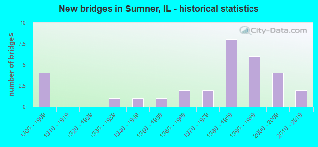
- New bridges - historical statistics
- 41900-1909
- 11930-1939
- 11940-1949
- 11950-1959
- 21960-1969
- 21970-1979
- 81980-1989
- 61990-1999
- 42000-2009
- 22010-2019


- Bridge Condition - Deck
- 29.6%Very good
- 18.5%Good
- 25.9%Satisfactory
- 22.2%Fair
- 3.7%Serious

- Bridge Condition - Superstructure
- 25.9%Very good
- 22.2%Good
- 25.9%Satisfactory
- 22.2%Fair
- 3.7%Serious

- Bridge Condition - Substructure
- 37.0%Very good
- 25.9%Good
- 14.8%Satisfactory
- 11.1%Fair
- 7.4%Poor
- 3.7%Serious

- Bridge Condition - Channel
- 32.3%Very good
- 25.8%Good
- 25.8%Satisfactory
- 12.9%Fair
- 3.2%Poor

- Bridge Condition - Culverts
- 25.0%Very good
- 50.0%Good
- 25.0%Poor
Find on map >> Show street view
Structure Number: 510009, Location: .5 MI E SUMNER RD (Lat: 38.731875, Lng: -87.859356), Route carried "on" structure: US 50, Year Built: 1946, Status: Posted for load, Structure Length: 4.24m (13.91ft), Average Daily Traffic: 4,050 (year 2021), Truck Traffic: 15%, Average Future Daily Traffic: 4,300 (year 2032), Design Load: H 20, Features Intersected: MUDDY CREEK
Minimum Vertical Clearance: 30+ m (98+ ft), Kilometerpoint: 229.245, Lanes on structure: 2, Base Highway Network: Yes, Owner: State Highway Agency, Approaching Roadway Width: 9.1m (29.9ft), Material/Design: Concrete continuous, Design/Construction: Tee Beam, Number Of Spans In Main Unit: 3, Length of Maximum Span: 17.1m (56.1ft), Curb-To-Curb Width: 9.8m (32.2ft), Out-to-Out Width: 10.5m (34.4ft)
Condition: Deck: Fair, Superstructure: Fair, Substructure: Satisfactory, Channel: Good, Operating Rating: 39.2 metric tons, Method Used To Determine Operating Rating: Load Factor (LF) rating reported by rating factor (RF) method using MS18 loading, Inventory Rating: 24.6 metric tons, Method Used To Determine Inventory Rating: Load Factor (LF) rating reported by rating factor (RF) method using MS18 loading, Structural Evaluation: Somewhat better than minimum adequacy, Deck Geometry: Meets minimum limits, Waterway Adequacy: Equal to present desirable criteria, Approach Roadway Alignment: Equal to present desirable criteria, Designated Inspection Frequency: Every 24 months, Inspection Date: Febuary 2021, Deck Structure Type: Concrete Cast-file-Place, Wearing Surface/Protective System: Wearing Surface: Bituminous, Membrane: Built-up
Find on map >> Show street view
Structure Number: 510052, Location: ECL SUMNER (Lat: 38.717372, Lng: -87.853128), Route carried "on" structure: State highway 250, Year Built: 1976, Status: Open, Structure Length: 3.47m (11.38ft), Average Daily Traffic: 2,200 (year 2021), Truck Traffic: 8%, Average Future Daily Traffic: 2,200 (year 2032), Design Load: HS 20, Features Intersected: MUDDY CREEK
Minimum Vertical Clearance: 30+ m (98+ ft), Kilometerpoint: 39.718, Lanes on structure: 2, Owner: State Highway Agency, Approaching Roadway Width: 7.3m (24.0ft), Material/Design: Concrete continuous, Design/Construction: Slab, Number Of Spans In Main Unit: 3, Length of Maximum Span: 12.5m (41.0ft), Curb-To-Curb Width: 9.1m (29.9ft), Out-to-Out Width: 9.9m (32.5ft)
Condition: Deck: Good, Superstructure: Good, Substructure: Good, Channel: Good, Operating Rating: 55.1 metric tons, Method Used To Determine Operating Rating: Load Factor (LF) rating reported by rating factor (RF) method using MS18 loading, Inventory Rating: 33.0 metric tons, Method Used To Determine Inventory Rating: Load Factor (LF) rating reported by rating factor (RF) method using MS18 loading, Structural Evaluation: Better than present minimum criteria, Deck Geometry: Meets minimum limits, Waterway Adequacy: Equal to present desirable criteria, Approach Roadway Alignment: Equal to present desirable criteria, Designated Inspection Frequency: Every 48 months, Inspection Date: June 2019, Deck Structure Type: Concrete Cast-file-Place, Wearing Surface/Protective System: Wearing Surface: Bituminous, Membrane: Built-up
Find on map >> Show street view
Structure Number: 510062, Location: SUMNER (Lat: 38.719864, Lng: -87.862081), Route carried "on" structure: State highway 250, Year Built: 2004, Status: Open, Structure Length: 4.36m (14.30ft), Average Daily Traffic: 2,200 (year 2021), Truck Traffic: 7%, Average Future Daily Traffic: 2,100 (year 2032), Design Load: HS 20, Features Intersected: SHIRLEY CREEK
Minimum Vertical Clearance: 30+ m (98+ ft), Kilometerpoint: 38.816, Lanes on structure: 2, Owner: State Highway Agency, Approaching Roadway Width: 7.8m (25.6ft), Skew: 2 degrees, Material/Design: Concrete continuous, Design/Construction: Slab, Number Of Spans In Main Unit: 3, Length of Maximum Span: 16.2m (53.1ft), Curb-To-Curb Width: 11.1m (36.4ft), Out-to-Out Width: 11.9m (39.0ft)
Condition: Deck: Fair, Superstructure: Fair, Substructure: Good, Channel: Very good, Operating Rating: 75.8 metric tons, Method Used To Determine Operating Rating: Load Factor (LF) rating reported by rating factor (RF) method using MS18 loading, Inventory Rating: 45.4 metric tons, Method Used To Determine Inventory Rating: Load Factor (LF) rating reported by rating factor (RF) method using MS18 loading, Structural Evaluation: Somewhat better than minimum adequacy, Deck Geometry: Somewhat better than minimum adequacy, Waterway Adequacy: Equal to present desirable criteria, Approach Roadway Alignment: Equal to present desirable criteria, Designated Inspection Frequency: Every 24 months, Inspection Date: September 2020, Deck Structure Type: Concrete Cast-file-Place, Wearing Surface/Protective System: Deck Protection: Epoxy Coated Reinforcing
Find on map >> Show street view
Structure Number: 513014, Location: 4 MI S SUMNER (Lat: 38.655461, Lng: -87.863333), Route carried "on" structure: County highway , Year Built: 1909, Year Reconstructed: 1968, Status: Open, Structure Length: 0.79m (2.59ft), Average Daily Traffic: 1,100 (year 2021), Truck Traffic: 17%, Average Future Daily Traffic: 900 (year 2032), Features Intersected: LITTLE BONPAS, Facility Carried by Structure: FAS-807
Minimum Vertical Clearance: 30+ m (98+ ft), Kilometerpoint: 7.000, Lanes on structure: 2, Owner: County Highway Agency, Approaching Roadway Width: 5.5m (18.0ft), Material/Design: Concrete, Design/Construction: Slab, Number Of Spans In Main Unit: 1, Length of Maximum Span: 7.6m (24.9ft), Curb-To-Curb Width: 7.6m (24.9ft), Out-to-Out Width: 8.3m (27.2ft)
Condition: Deck: Fair, Superstructure: Fair, Substructure: Fair, Channel: Fair, Operating Rating: 32.4 metric tons, Method Used To Determine Operating Rating: Field evaluation and documented engineering judgment, Inventory Rating: 17.5 metric tons, Method Used To Determine Inventory Rating: Field evaluation and documented engineering judgment, Structural Evaluation: Meets minimum limits, Deck Geometry: Meets minimum limits, Waterway Adequacy: Somewhat better than minimum adequacy, Approach Roadway Alignment: Better than present minimum criteria, Designated Inspection Frequency: Every 24 months, Inspection Date: January 2021, Deck Structure Type: Concrete Cast-file-Place, Wearing Surface/Protective System: Wearing Surface: Bituminous
Find on map >> Show street view
Structure Number: 513033, Location: 3 MI N SUMNER (Lat: 38.769600, Lng: -87.865967), Route carried "on" structure: County highway , Year Built: 1954, Status: Open, Structure Length: 3.47m (11.38ft), Average Daily Traffic: 900 (year 2021), Truck Traffic: 14%, Average Future Daily Traffic: 850 (year 2032), Design Load: HS 15, Features Intersected: BUGABOO CREEK, Facility Carried by Structure: FAS-694
Minimum Vertical Clearance: 30+ m (98+ ft), Kilometerpoint: 9.205, Lanes on structure: 2, Owner: County Highway Agency, Approaching Roadway Width: 6.1m (20.0ft), Skew: 3 degrees, Material/Design: Steel continuous, Design/Construction: Stringer/Multi-beam, Number Of Spans In Main Unit: 3, Length of Maximum Span: 13.1m (43.0ft), Curb-To-Curb Width: 7.3m (24.0ft), Out-to-Out Width: 8.6m (28.2ft)
Condition: Deck: Satisfactory, Superstructure: Satisfactory, Substructure: Satisfactory, Channel: Satisfactory, Operating Rating: 43.1 metric tons, Method Used To Determine Operating Rating: Load Factor (LF) rating reported by rating factor (RF) method using MS18 loading, Inventory Rating: 25.9 metric tons, Method Used To Determine Inventory Rating: Load Factor (LF) rating reported by rating factor (RF) method using MS18 loading, Structural Evaluation: Equal to present minimum criteria, Deck Geometry: Meets minimum limits, Waterway Adequacy: Equal to present desirable criteria, Approach Roadway Alignment: Better than present minimum criteria, Designated Inspection Frequency: Every 24 months, Inspection Date: January 2022, Deck Structure Type: Concrete Cast-file-Place
Find on map >> Show street view
Structure Number: 513039, Location: 1 MI W SUMNER (Lat: 38.723072, Lng: -87.890300), Route carried "on" structure: County highway , Year Built: 1909, Status: Open, Structure Length: 0.98m (3.22ft), Average Daily Traffic: 75 (year 2021), Truck Traffic: 8%, Average Future Daily Traffic: 25 (year 2032), Features Intersected: SHIRLEY CREEK, Facility Carried by Structure: TR-10
Minimum Vertical Clearance: 30+ m (98+ ft), Kilometerpoint: 0.982, Lanes on structure: 1, Owner: Town or Township Highway Agency, Approaching Roadway Width: 6.7m (22.0ft), Material/Design: Concrete, Number Of Spans In Main Unit: 1, Length of Maximum Span: 9.4m (30.8ft), Curb-To-Curb Width: 4.5m (14.8ft), Out-to-Out Width: 5.6m (18.4ft)
Condition: Deck: Fair, Superstructure: Fair, Substructure: Poor, Channel: Fair, Operating Rating: 40.5 metric tons, Method Used To Determine Operating Rating: Field evaluation and documented engineering judgment, Inventory Rating: 24.3 metric tons, Method Used To Determine Inventory Rating: Field evaluation and documented engineering judgment, Structural Evaluation: Meets minimum limits, Deck Geometry: Equal to present minimum criteria, Waterway Adequacy: Equal to present minimum criteria, Approach Roadway Alignment: Equal to present minimum criteria, Designated Inspection Frequency: Every 24 months, Inspection Date: January 2022, Deck Structure Type: Concrete Cast-file-Place, Wearing Surface/Protective System: Wearing Surface: Gravel
Find on map >> Show street view
Structure Number: 513049, Location: 4.75 MI S CHAUNCEY (Lat: 38.765364, Lng: -87.880267), Route carried "on" structure: County highway , Year Built: 1960, Status: Posted for load, Structure Length: 1.49m (4.89ft), Average Daily Traffic: 50 (year 2021), Truck Traffic: 2%, Average Future Daily Traffic: 125 (year 2032), Design Load: HS 15, Features Intersected: BUGABOO CREEK, Facility Carried by Structure: TR-18
Minimum Vertical Clearance: 30+ m (98+ ft), Kilometerpoint: 3.637, Lanes on structure: 2, Owner: Town or Township Highway Agency, Approaching Roadway Width: 5.5m (18.0ft), Material/Design: Prestressed concrete, Design/Construction: Box Beam or Girders - Multiple, Number Of Spans In Main Unit: 1, Length of Maximum Span: 14.3m (46.9ft), Curb-To-Curb Width: 6.8m (22.3ft), Out-to-Out Width: 7.3m (24.0ft)
Condition: Deck: Serious, Superstructure: Serious, Substructure: Serious, Channel: Satisfactory, Operating Rating: 33.7 metric tons, Method Used To Determine Operating Rating: Allowable Stress (AS) rating reported by rating factor (RF) method using MS18 loading, Structural Evaluation: High priority of corrective action, Deck Geometry: Somewhat better than minimum adequacy, Waterway Adequacy: Somewhat better than minimum adequacy, Approach Roadway Alignment: Equal to present desirable criteria, Bridge Posting: Required (Relationship of Operating Rating to Maximum Legal Load: > 39.9% below), Designated Inspection Frequency: Every 24 months, Other Special Inspection Frequency: Every 12 months, Inspection Date: January 2020, Other Special Inspection Date: December 2020, Deck Structure Type: Concrete Precast Panels
Find on map >> Show street view
Structure Number: 513068, Location: 4 MI S CHAUNCEY (Lat: 38.776133, Lng: -87.877269), Route carried "on" structure: County highway , Year Built: 1969, Status: Open, Structure Length: 2.80m (9.19ft), Average Daily Traffic: 50 (year 2021), Truck Traffic: 2%, Average Future Daily Traffic: 100 (year 2032), Design Load: HS 15, Features Intersected: PAUL CREEK, Facility Carried by Structure: TR-91
Minimum Vertical Clearance: 30+ m (98+ ft), Kilometerpoint: 2.704, Lanes on structure: 2, Owner: Town or Township Highway Agency, Approaching Roadway Width: 7.3m (24.0ft), Skew: 2 degrees, Material/Design: Prestressed concrete, Design/Construction: Box Beam or Girders - Multiple, Number Of Spans In Main Unit: 2, Length of Maximum Span: 13.7m (44.9ft), Curb-To-Curb Width: 7.3m (24.0ft), Out-to-Out Width: 8.0m (26.2ft)
Condition: Deck: Satisfactory, Superstructure: Satisfactory, Substructure: Satisfactory, Channel: Satisfactory, Operating Rating: 42.8 metric tons, Method Used To Determine Operating Rating: Load Factor (LF) rating reported by rating factor (RF) method using MS18 loading, Inventory Rating: 25.6 metric tons, Method Used To Determine Inventory Rating: Load Factor (LF) rating reported by rating factor (RF) method using MS18 loading, Structural Evaluation: Equal to present minimum criteria, Deck Geometry: Equal to present minimum criteria, Waterway Adequacy: Equal to present desirable criteria, Approach Roadway Alignment: Better than present minimum criteria, Designated Inspection Frequency: Every 24 months, Inspection Date: January 2021, Deck Structure Type: Concrete Precast Panels
Find on map >> Show street view
Structure Number: 513088, Location: 1 MI SW SUMNER (Lat: 38.687728, Lng: -87.879361), Route carried "on" structure: County highway , Year Built: 1909, Year Reconstructed: 1973, Status: Open, Structure Length: 0.98m (3.22ft), Average Daily Traffic: 150 (year 2021), Truck Traffic: 13%, Average Future Daily Traffic: 125 (year 2032), Features Intersected: CRABAPPLE CREEK, Facility Carried by Structure: TR-179
Minimum Vertical Clearance: 30+ m (98+ ft), Kilometerpoint: 2.607, Lanes on structure: 2, Owner: Town or Township Highway Agency, Approaching Roadway Width: 7.3m (24.0ft), Material/Design: Concrete, Design/Construction: Slab, Number Of Spans In Main Unit: 1, Length of Maximum Span: 7.6m (24.9ft), Curb-To-Curb Width: 7.2m (23.6ft), Out-to-Out Width: 7.8m (25.6ft)
Condition: Deck: Satisfactory, Superstructure: Satisfactory, Substructure: Fair, Channel: Satisfactory, Operating Rating: 40.5 metric tons, Method Used To Determine Operating Rating: Field evaluation and documented engineering judgment, Inventory Rating: 24.3 metric tons, Method Used To Determine Inventory Rating: Field evaluation and documented engineering judgment, Structural Evaluation: Somewhat better than minimum adequacy, Deck Geometry: Meets minimum limits, Waterway Adequacy: Equal to present minimum criteria, Approach Roadway Alignment: Equal to present minimum criteria, Designated Inspection Frequency: Every 24 months, Inspection Date: January 2022, Deck Structure Type: Concrete Cast-file-Place, Wearing Surface/Protective System: Wearing Surface: Bituminous
Find on map >> Show street view
Structure Number: 513237, Location: 2.5 MI NE SUMNER (Lat: 38.754672, Lng: -87.908775), Route carried "on" structure: County highway , Year Built: 1981, Status: Open, Structure Length: 2.19m (7.19ft), Average Daily Traffic: 75 (year 2021), Truck Traffic: 7%, Average Future Daily Traffic: 100 (year 2032), Design Load: HS 20, Features Intersected: BUGABOO CREEK, Facility Carried by Structure: TR-2
Minimum Vertical Clearance: 30+ m (98+ ft), Kilometerpoint: 10.557, Lanes on structure: 2, Owner: Town or Township Highway Agency, Approaching Roadway Width: 7.3m (24.0ft), Skew: 1 degrees, Material/Design: Concrete, Design/Construction: Channel Beam, Number Of Spans In Main Unit: 3, Length of Maximum Span: 7.6m (24.9ft), Curb-To-Curb Width: 8.1m (26.6ft), Out-to-Out Width: 8.1m (26.6ft)
Condition: Deck: Fair, Superstructure: Fair, Substructure: Good, Channel: Good, Operating Rating: 44.4 metric tons, Method Used To Determine Operating Rating: Assigned rating based on Load Factor Design (LFD) reported by rating factor (RF) using MS18 loading, Inventory Rating: 32.4 metric tons, Method Used To Determine Inventory Rating: Assigned rating based on Load Factor Design (LFD) reported by rating factor (RF) using MS18 loading, Structural Evaluation: Somewhat better than minimum adequacy, Deck Geometry: Equal to present minimum criteria, Waterway Adequacy: Better than present minimum criteria, Approach Roadway Alignment: Equal to present minimum criteria, Designated Inspection Frequency: Every 24 months, Inspection Date: January 2022, Deck Structure Type: Concrete Precast Panels
Find on map >> Show street view
Structure Number: 513239, Location: 2 MI S SUMNER (Lat: 38.693342, Lng: -87.876361), Route carried "on" structure: County highway , Year Built: 1982, Status: Open, Structure Length: 1.58m (5.18ft), Average Daily Traffic: 50 (year 2021), Truck Traffic: 16%, Average Future Daily Traffic: 50 (year 2032), Design Load: HS 20, Features Intersected: CRABAPPLE CREEK, Facility Carried by Structure: TR-16
Minimum Vertical Clearance: 30+ m (98+ ft), Kilometerpoint: 2.237, Lanes on structure: 2, Owner: Town or Township Highway Agency, Approaching Roadway Width: 7.3m (24.0ft), Material/Design: Prestressed concrete, Design/Construction: Box Beam or Girders - Multiple, Number Of Spans In Main Unit: 1, Length of Maximum Span: 15.5m (50.9ft), Curb-To-Curb Width: 7.4m (24.3ft), Out-to-Out Width: 7.4m (24.3ft)
Condition: Deck: Satisfactory, Superstructure: Satisfactory, Substructure: Good, Channel: Good, Operating Rating: 44.4 metric tons, Method Used To Determine Operating Rating: Assigned rating based on Load Factor Design (LFD) reported by rating factor (RF) using MS18 loading, Inventory Rating: 32.4 metric tons, Method Used To Determine Inventory Rating: Assigned rating based on Load Factor Design (LFD) reported by rating factor (RF) using MS18 loading, Structural Evaluation: Equal to present minimum criteria, Deck Geometry: Equal to present minimum criteria, Waterway Adequacy: Equal to present minimum criteria, Approach Roadway Alignment: Better than present minimum criteria, Designated Inspection Frequency: Every 24 months, Inspection Date: January 2022, Deck Structure Type: Concrete Precast Panels
Find on map >> Show street view
Structure Number: 51324, Location: 1.75 MI N RED HIL SP (Lat: 38.772231, Lng: -87.832875), Route carried "on" structure: County highway , Year Built: 1982, Status: Open, Structure Length: 4.05m (13.29ft), Average Daily Traffic: 50 (year 2021), Truck Traffic: 2%, Average Future Daily Traffic: 75 (year 2032), Design Load: HS 20, Features Intersected: MUDDY CREEK, Facility Carried by Structure: TR-40
Minimum Vertical Clearance: 30+ m (98+ ft), Kilometerpoint: 8.626, Lanes on structure: 2, Owner: Town or Township Highway Agency, Approaching Roadway Width: 6.7m (22.0ft), Skew: 3 degrees, Material/Design: Prestressed concrete, Design/Construction: Box Beam or Girders - Multiple, Number Of Spans In Main Unit: 3, Length of Maximum Span: 15.2m (49.9ft), Curb-To-Curb Width: 7.4m (24.3ft), Out-to-Out Width: 7.4m (24.3ft)
Condition: Deck: Satisfactory, Superstructure: Satisfactory, Substructure: Good, Channel: Very good, Operating Rating: 44.4 metric tons, Method Used To Determine Operating Rating: Assigned rating based on Load Factor Design (LFD) reported by rating factor (RF) using MS18 loading, Inventory Rating: 32.4 metric tons, Method Used To Determine Inventory Rating: Assigned rating based on Load Factor Design (LFD) reported by rating factor (RF) using MS18 loading, Structural Evaluation: Equal to present minimum criteria, Deck Geometry: Equal to present minimum criteria, Waterway Adequacy: Better than present minimum criteria, Approach Roadway Alignment: Better than present minimum criteria, Designated Inspection Frequency: Every 24 months, Inspection Date: December 2019, Deck Structure Type: Concrete Precast Panels
Find on map >> Show street view
Structure Number: 513257, Location: 2.5 MI NNWSUMNER (Lat: 38.762464, Lng: -87.889786), Route carried "on" structure: County highway , Year Built: 1991, Status: Open, Structure Length: 1.88m (6.17ft), Average Daily Traffic: 20 (year 2021), Truck Traffic: 5%, Average Future Daily Traffic: 50 (year 2032), Design Load: HS 20, Features Intersected: BUGABOO CREEK, Facility Carried by Structure: TR-10A
Minimum Vertical Clearance: 30+ m (98+ ft), Kilometerpoint: 9.720, Lanes on structure: 2, Owner: Town or Township Highway Agency, Approaching Roadway Width: 5.5m (18.0ft), Skew: 1 degrees, Material/Design: Prestressed concrete, Design/Construction: Box Beam or Girders - Multiple, Number Of Spans In Main Unit: 1, Length of Maximum Span: 17.9m (58.7ft), Curb-To-Curb Width: 7.4m (24.3ft), Out-to-Out Width: 7.4m (24.3ft)
Condition: Deck: Good, Superstructure: Good, Substructure: Good, Channel: Very good, Operating Rating: 67.7 metric tons, Method Used To Determine Operating Rating: Load Factor (LF) rating reported by rating factor (RF) method using MS18 loading, Inventory Rating: 40.5 metric tons, Method Used To Determine Inventory Rating: Load Factor (LF) rating reported by rating factor (RF) method using MS18 loading, Structural Evaluation: Better than present minimum criteria, Deck Geometry: Equal to present minimum criteria, Waterway Adequacy: Superior to present desirable criteria, Approach Roadway Alignment: Equal to present desirable criteria, Designated Inspection Frequency: Every 48 months, Inspection Date: January 2019, Deck Structure Type: Concrete Precast Panels
Find on map >> Show street view
Structure Number: 513258, Location: S EDGE SUMNER (Lat: 38.705978, Lng: -87.862075), Route carried "on" structure: County highway , Year Built: 1993, Status: Open, Structure Length: 2.80m (9.19ft), Average Daily Traffic: 1,400 (year 2021), Truck Traffic: 16%, Average Future Daily Traffic: 1,300 (year 2032), Design Load: HS 20, Features Intersected: CRABAPPLE CREEK, Facility Carried by Structure: FAS-807
Minimum Vertical Clearance: 30+ m (98+ ft), Kilometerpoint: 1.384, Lanes on structure: 2, Owner: County Highway Agency, Approaching Roadway Width: 6.1m (20.0ft), Skew: 2 degrees, Material/Design: Prestressed concrete, Design/Construction: Box Beam or Girders - Multiple, Number Of Spans In Main Unit: 3, Length of Maximum Span: 9.1m (29.9ft), Curb-To-Curb Width: 8.5m (27.9ft), Out-to-Out Width: 8.5m (27.9ft)
Condition: Deck: Fair, Superstructure: Fair, Substructure: Fair, Channel: Satisfactory, Operating Rating: 44.1 metric tons, Method Used To Determine Operating Rating: Assigned rating based on Load Factor Design (LFD) reported by rating factor (RF) using MS18 loading, Inventory Rating: 32.4 metric tons, Method Used To Determine Inventory Rating: Assigned rating based on Load Factor Design (LFD) reported by rating factor (RF) using MS18 loading, Structural Evaluation: Somewhat better than minimum adequacy, Deck Geometry: Somewhat better than minimum adequacy, Waterway Adequacy: Equal to present desirable criteria, Approach Roadway Alignment: Better than present minimum criteria, Designated Inspection Frequency: Every 24 months, Inspection Date: January 2022, Deck Structure Type: Concrete Precast Panels, Wearing Surface/Protective System: Wearing Surface: Bituminous
Find on map >> Show street view
Structure Number: 513269, Location: 4 MI S CHAUNCEY (Lat: 38.778044, Lng: -87.880214), Route carried "on" structure: County highway , Year Built: 2000, Status: Open, Structure Length: 2.33m (7.64ft), Average Daily Traffic: 25 (year 2021), Truck Traffic: 8%, Average Future Daily Traffic: 10 (year 2032), Design Load: HS 20, Features Intersected: PAUL CREEK, Facility Carried by Structure: TR 18
Minimum Vertical Clearance: 30+ m (98+ ft), Kilometerpoint: 2.221, Lanes on structure: 2, Owner: Town or Township Highway Agency, Approaching Roadway Width: 6.1m (20.0ft), Material/Design: Prestressed concrete, Design/Construction: Box Beam or Girders - Multiple, Number Of Spans In Main Unit: 3, Length of Maximum Span: 7.6m (24.9ft), Curb-To-Curb Width: 8.5m (27.9ft), Out-to-Out Width: 8.5m (27.9ft)
Condition: Deck: Very good, Superstructure: Good, Substructure: Good, Channel: Satisfactory, Operating Rating: 44.1 metric tons, Method Used To Determine Operating Rating: Assigned rating based on Load Factor Design (LFD) reported by rating factor (RF) using MS18 loading, Inventory Rating: 32.4 metric tons, Method Used To Determine Inventory Rating: Assigned rating based on Load Factor Design (LFD) reported by rating factor (RF) using MS18 loading, Structural Evaluation: Better than present minimum criteria, Deck Geometry: Better than present minimum criteria, Waterway Adequacy: Equal to present minimum criteria, Approach Roadway Alignment: Equal to present desirable criteria, Designated Inspection Frequency: Every 48 months, Inspection Date: January 2019, Deck Structure Type: Concrete Precast Panels
Find on map >> Show street view
Structure Number: 513298, Location: 4 MI SSW CHAUNCEY (Lat: 38.781814, Lng: -87.889633), Route carried "on" structure: County highway , Year Built: 2011, Status: Open, Structure Length: 1.87m (6.14ft), Average Daily Traffic: 25 (year 2021), Truck Traffic: 8%, Average Future Daily Traffic: 25 (year 2032), Design Load: HS 25 or greater, Features Intersected: PAUL CREEK, Facility Carried by Structure: TR 10 A
Minimum Vertical Clearance: 30+ m (98+ ft), Kilometerpoint: 7.564, Lanes on structure: 2, Owner: Town or Township Highway Agency, Approaching Roadway Width: 6.1m (20.0ft), Material/Design: Prestressed concrete, Design/Construction: Box Beam or Girders - Multiple, Number Of Spans In Main Unit: 1, Length of Maximum Span: 17.7m (58.1ft), Curb-To-Curb Width: 8.5m (27.9ft), Out-to-Out Width: 8.5m (27.9ft)
Condition: Deck: Good, Superstructure: Good, Substructure: Very good, Channel: Very good, Operating Rating: 44.1 metric tons, Method Used To Determine Operating Rating: Assigned rating based on Load Factor Design (LFD) reported by rating factor (RF) using MS18 loading, Inventory Rating: 32.4 metric tons, Method Used To Determine Inventory Rating: Assigned rating based on Load Factor Design (LFD) reported by rating factor (RF) using MS18 loading, Structural Evaluation: Better than present minimum criteria, Deck Geometry: Better than present minimum criteria, Waterway Adequacy: Better than present minimum criteria, Approach Roadway Alignment: Equal to present desirable criteria, Designated Inspection Frequency: Every 48 months, Inspection Date: January 2022, Deck Structure Type: Concrete Precast Panels
Find on map >> Show street view
Structure Number: 515001, Location: 4 MI S SUMNER (Lat: 38.653289, Lng: -87.863564), Route carried "on" structure: County highway , Year Built: 1939, Status: Open, Structure Length: 0.71m (2.33ft), Average Daily Traffic: 1,100 (year 2021), Truck Traffic: 17%, Average Future Daily Traffic: 900 (year 2032), Features Intersected: LITTLE BONPAS CREEK, Facility Carried by Structure: FAS-807 (CH-6)
Minimum Vertical Clearance: 30+ m (98+ ft), Kilometerpoint: 7.242, Lanes on structure: 2, Owner: County Highway Agency, Approaching Roadway Width: 5.5m (18.0ft), Material/Design: Concrete continuous, Design/Construction: Culvert, Number Of Spans In Main Unit: 3, Length of Maximum Span: 2.3m (7.5ft)
Condition: Channel: Fair, Culverts: Poor, Operating Rating: 41.5 metric tons, Method Used To Determine Operating Rating: Load Factor (LF) rating reported by rating factor (RF) method using MS18 loading, Inventory Rating: 24.6 metric tons, Method Used To Determine Inventory Rating: Load Factor (LF) rating reported by rating factor (RF) method using MS18 loading, Structural Evaluation: Meets minimum limits, Waterway Adequacy: Somewhat better than minimum adequacy, Approach Roadway Alignment: Better than present minimum criteria, Designated Inspection Frequency: Every 24 months, Inspection Date: January 2021, Wearing Surface/Protective System: Wearing Surface: Bituminous
Find on map >> Show street view
Structure Number: 515011, Location: 3 MI SE SUMNER (Lat: 38.665400, Lng: -87.825683), Route carried "on" structure: County highway , Year Built: 1993, Status: Open, Structure Length: 0.79m (2.59ft), Average Daily Traffic: 20 (year 2021), Truck Traffic: 5%, Average Future Daily Traffic: 25 (year 2032), Design Load: HS 20, Features Intersected: TRIB RACCOON CREEK, Facility Carried by Structure: TR-50
Minimum Vertical Clearance: 30+ m (98+ ft), Kilometerpoint: 4.039, Lanes on structure: 2, Owner: Town or Township Highway Agency, Approaching Roadway Width: 6.1m (20.0ft), Material/Design: Concrete, Design/Construction: Culvert, Number Of Spans In Main Unit: 2, Length of Maximum Span: 3.6m (11.8ft)
Condition: Channel: Satisfactory, Culverts: Very good, Operating Rating: 44.4 metric tons, Method Used To Determine Operating Rating: Assigned rating based on Load Factor Design (LFD) reported by rating factor (RF) using MS18 loading, Inventory Rating: 32.4 metric tons, Method Used To Determine Inventory Rating: Assigned rating based on Load Factor Design (LFD) reported by rating factor (RF) using MS18 loading, Structural Evaluation: Equal to present desirable criteria, Waterway Adequacy: Equal to present desirable criteria, Approach Roadway Alignment: Equal to present desirable criteria, Designated Inspection Frequency: Every 48 months, Inspection Date: January 2019
Find on map >> Show street view
Structure Number: 515013, Location: NE RED HILLS ST PK (Lat: 38.745597, Lng: -87.824211), Route carried "on" structure: County highway , Year Built: 1993, Status: Open, Structure Length: 0.69m (2.26ft), Average Daily Traffic: 100 (year 2021), Truck Traffic: 1%, Average Future Daily Traffic: 125 (year 2032), Design Load: HS 20, Features Intersected: TRIB MUDDY CREEK, Facility Carried by Structure: CH-23
Minimum Vertical Clearance: 30+ m (98+ ft), Kilometerpoint: 3.186, Lanes on structure: 2, Owner: County Highway Agency, Approaching Roadway Width: 6.1m (20.0ft), Material/Design: Concrete, Design/Construction: Culvert, Number Of Spans In Main Unit: 2, Length of Maximum Span: 3.3m (10.8ft)
Condition: Channel: Good, Culverts: Good, Operating Rating: 53.8 metric tons, Method Used To Determine Operating Rating: Field evaluation and documented engineering judgment, Inventory Rating: 32.4 metric tons, Method Used To Determine Inventory Rating: Field evaluation and documented engineering judgment, Structural Evaluation: Better than present minimum criteria, Waterway Adequacy: Equal to present desirable criteria, Approach Roadway Alignment: Equal to present desirable criteria, Designated Inspection Frequency: Every 48 months, Inspection Date: January 2019
Find on map >> Show street view
Structure Number: 516004, Location: SUMNER (Lat: 38.713669, Lng: -87.855022), Route carried "on" structure: City street , Year Built: 1973, Status: Open, Structure Length: 1.92m (6.30ft), Average Daily Traffic: 50 (year 2021), Truck Traffic: 2%, Average Future Daily Traffic: 125 (year 2032), Design Load: HS 15, Features Intersected: CRABAPPLE CREEK, Facility Carried by Structure: CEDAR STREET 3100
Minimum Vertical Clearance: 30+ m (98+ ft), Kilometerpoint: 1.448, Lanes on structure: 2, Owner: City or Municipal Highway Agency, Approaching Roadway Width: 5.5m (18.0ft), Skew: 3 degrees, Material/Design: Prestressed concrete, Design/Construction: Box Beam or Girders - Multiple, Number Of Spans In Main Unit: 2, Length of Maximum Span: 9.1m (29.9ft), Curb-To-Curb Width: 7.1m (23.3ft), Out-to-Out Width: 8.0m (26.2ft)
Condition: Deck: Satisfactory, Superstructure: Satisfactory, Substructure: Satisfactory, Channel: Satisfactory, Operating Rating: 32.4 metric tons, Method Used To Determine Operating Rating: Field evaluation and documented engineering judgment, Inventory Rating: 17.5 metric tons, Method Used To Determine Inventory Rating: Field evaluation and documented engineering judgment, Structural Evaluation: Somewhat better than minimum adequacy, Deck Geometry: Somewhat better than minimum adequacy, Waterway Adequacy: Equal to present minimum criteria, Approach Roadway Alignment: Better than present minimum criteria, Length Of Structure Improvement: 1.92m (6.30ft), Designated Inspection Frequency: Every 24 months, Inspection Date: January 2022, Bridge Improvement Cost: $580,000, Roadway Improvement Cost: $66,000, Total Project Cost: $646,000, Deck Structure Type: Concrete Precast Panels
Find on map >> Show street view
Structure Number: 803109, Location: 1.5 MI SW AMITY (Lat: 38.765647, Lng: -87.937069), Route carried "on" structure: County highway , Year Built: 1909, Status: Posted for load, Structure Length: 0.91m (2.99ft), Average Daily Traffic: 25 (year 2018), Truck Traffic: 8%, Average Future Daily Traffic: 10 (year 2032), Features Intersected: Paul Creek, Facility Carried by Structure: TR-266
Minimum Vertical Clearance: 30+ m (98+ ft), Kilometerpoint: 1.191, Lanes on structure: 1, Owner: Town or Township Highway Agency, Approaching Roadway Width: 6.1m (20.0ft), Material/Design: Steel, Design/Construction: Stringer/Multi-beam, Number Of Spans In Main Unit: 1, Length of Maximum Span: 8.9m (29.2ft), Curb-To-Curb Width: 3.7m (12.1ft), Out-to-Out Width: 4.3m (14.1ft)
Condition: Deck: Satisfactory, Superstructure: Satisfactory, Substructure: Poor, Channel: Fair, Operating Rating: 13.3 metric tons, Method Used To Determine Operating Rating: Load Factor (LF) rating reported by rating factor (RF) method using MS18 loading, Inventory Rating: 7.8 metric tons, Method Used To Determine Inventory Rating: Load Factor (LF) rating reported by rating factor (RF) method using MS18 loading, Structural Evaluation: High priority of replacement, Deck Geometry: Meets minimum limits, Waterway Adequacy: High priority of corrective action, Approach Roadway Alignment: Somewhat better than minimum adequacy, Bridge Posting: Required (Relationship of Operating Rating to Maximum Legal Load: > 39.9% below), Length Of Structure Improvement: 1.55m (5.09ft), Designated Inspection Frequency: Every 24 months, Inspection Date: January 2022, Bridge Improvement Cost: $43,000, Roadway Improvement Cost: $5,000, Total Project Cost: $65,000, Deck Structure Type: Wood or Timber, Wearing Surface/Protective System: Wearing Surface: Wood or Timber
Find on map >> Show street view
Structure Number: 803131, Location: 0.75 MI E AMITY (Lat: 38.776314, Lng: -87.913519), Route carried "on" structure: County highway , Year Built: 2000, Status: Open, Structure Length: 2.73m (8.96ft), Average Daily Traffic: 50 (year 2018), Truck Traffic: 4%, Average Future Daily Traffic: 25 (year 2032), Design Load: HS 20, Features Intersected: PAUL CREEK, Facility Carried by Structure: TR 75
Minimum Vertical Clearance: 30+ m (98+ ft), Kilometerpoint: 1.207, Lanes on structure: 2, Owner: Town or Township Highway Agency, Approaching Roadway Width: 6.1m (20.0ft), Skew: 3 degrees, Material/Design: Prestressed concrete, Design/Construction: Box Beam or Girders - Multiple, Number Of Spans In Main Unit: 3, Length of Maximum Span: 14.4m (47.2ft), Curb-To-Curb Width: 7.3m (24.0ft), Out-to-Out Width: 7.3m (24.0ft)
Condition: Deck: Very good, Superstructure: Very good, Substructure: Very good, Channel: Very good, Operating Rating: 44.1 metric tons, Method Used To Determine Operating Rating: Assigned rating based on Load Factor Design (LFD) reported by rating factor (RF) using MS18 loading, Inventory Rating: 32.4 metric tons, Method Used To Determine Inventory Rating: Assigned rating based on Load Factor Design (LFD) reported by rating factor (RF) using MS18 loading, Structural Evaluation: Equal to present desirable criteria, Deck Geometry: Equal to present minimum criteria, Waterway Adequacy: Equal to present minimum criteria, Approach Roadway Alignment: Equal to present desirable criteria, Designated Inspection Frequency: Every 48 months, Inspection Date: January 2022, Deck Structure Type: Concrete Precast Panels
Find on map >> Show street view
Structure Number: 803132, Location: 0.5 MI E AMITY (Lat: 38.776303, Lng: -87.916175), Route carried "on" structure: County highway , Year Built: 1996, Status: Open, Structure Length: 1.72m (5.64ft), Average Daily Traffic: 50 (year 2018), Truck Traffic: 4%, Average Future Daily Traffic: 25 (year 2032), Design Load: HS 20, Features Intersected: PAUL CREEK, Facility Carried by Structure: TR 75
Minimum Vertical Clearance: 30+ m (98+ ft), Kilometerpoint: 0.982, Lanes on structure: 2, Owner: Town or Township Highway Agency, Approaching Roadway Width: 7.3m (24.0ft), Skew: 3 degrees, Material/Design: Prestressed concrete, Design/Construction: Box Beam or Girders - Multiple, Number Of Spans In Main Unit: 1, Length of Maximum Span: 16.4m (53.8ft), Curb-To-Curb Width: 7.3m (24.0ft), Out-to-Out Width: 7.3m (24.0ft)
Condition: Deck: Very good, Superstructure: Very good, Substructure: Very good, Channel: Very good, Operating Rating: 44.1 metric tons, Method Used To Determine Operating Rating: Assigned rating based on Load Factor Design (LFD) reported by rating factor (RF) using MS18 loading, Inventory Rating: 32.4 metric tons, Method Used To Determine Inventory Rating: Assigned rating based on Load Factor Design (LFD) reported by rating factor (RF) using MS18 loading, Structural Evaluation: Equal to present desirable criteria, Deck Geometry: Equal to present minimum criteria, Waterway Adequacy: Equal to present minimum criteria, Approach Roadway Alignment: Better than present minimum criteria, Designated Inspection Frequency: Every 48 months, Inspection Date: January 2022, Deck Structure Type: Concrete Precast Panels
Find on map >> Show street view
Structure Number: 803148, Location: 3 MI E CLAREMONT (Lat: 38.717289, Lng: -87.911825), Route carried "on" structure: County highway , Year Built: 1983, Status: Open, Structure Length: 1.55m (5.09ft), Average Daily Traffic: 50 (year 2018), Truck Traffic: 2%, Average Future Daily Traffic: 50 (year 2032), Design Load: HS 20, Features Intersected: SHIRLEY CREEK, Facility Carried by Structure: TR-141
Minimum Vertical Clearance: 30+ m (98+ ft), Kilometerpoint: 4.683, Lanes on structure: 2, Owner: Town or Township Highway Agency, Approaching Roadway Width: 7.3m (24.0ft), Material/Design: Prestressed concrete, Design/Construction: Box Beam or Girders - Multiple, Number Of Spans In Main Unit: 1, Length of Maximum Span: 14.9m (48.9ft), Curb-To-Curb Width: 7.4m (24.3ft), Out-to-Out Width: 7.4m (24.3ft)
Condition: Deck: Good, Superstructure: Good, Substructure: Very good, Channel: Good, Operating Rating: 44.4 metric tons, Method Used To Determine Operating Rating: Assigned rating based on Load Factor Design (LFD) reported by rating factor (RF) using MS18 loading, Inventory Rating: 32.4 metric tons, Method Used To Determine Inventory Rating: Assigned rating based on Load Factor Design (LFD) reported by rating factor (RF) using MS18 loading, Structural Evaluation: Better than present minimum criteria, Deck Geometry: Equal to present minimum criteria, Waterway Adequacy: Equal to present desirable criteria, Approach Roadway Alignment: Equal to present desirable criteria, Designated Inspection Frequency: Every 48 months, Inspection Date: January 2019, Deck Structure Type: Concrete Precast Panels
Find on map >> Show street view
Structure Number: 803149, Location: 3 MI E CLAREMONT (Lat: 38.720647, Lng: -87.909061), Route carried "on" structure: County highway , Year Built: 1983, Status: Open, Structure Length: 1.55m (5.09ft), Average Daily Traffic: 150 (year 2021), Truck Traffic: 34%, Average Future Daily Traffic: 600 (year 2032), Design Load: HS 20, Features Intersected: SHIRLEY CREEK, Facility Carried by Structure: TR-2A (LAWRENCE CO
Minimum Vertical Clearance: 30+ m (98+ ft), Kilometerpoint: 0.338, Lanes on structure: 2, Owner: Town or Township Highway Agency, Approaching Roadway Width: 7.3m (24.0ft), Skew: 3 degrees, Material/Design: Prestressed concrete, Design/Construction: Box Beam or Girders - Multiple, Number Of Spans In Main Unit: 1, Length of Maximum Span: 14.9m (48.9ft), Curb-To-Curb Width: 7.4m (24.3ft), Out-to-Out Width: 7.4m (24.3ft)
Condition: Deck: Good, Superstructure: Good, Substructure: Very good, Channel: Good, Operating Rating: 44.4 metric tons, Method Used To Determine Operating Rating: Assigned rating based on Load Factor Design (LFD) reported by rating factor (RF) using MS18 loading, Inventory Rating: 32.4 metric tons, Method Used To Determine Inventory Rating: Assigned rating based on Load Factor Design (LFD) reported by rating factor (RF) using MS18 loading, Structural Evaluation: Better than present minimum criteria, Deck Geometry: Somewhat better than minimum adequacy, Waterway Adequacy: Better than present minimum criteria, Approach Roadway Alignment: Equal to present desirable criteria, Designated Inspection Frequency: Every 48 months, Inspection Date: January 2019, Deck Structure Type: Concrete Precast Panels
Find on map >> Show street view
Structure Number: 803153, Location: 0.5 MI S AMITY (Lat: 38.771631, Lng: -87.927528), Route carried "on" structure: County highway , Year Built: 1985, Status: Open, Structure Length: 2.50m (8.20ft), Average Daily Traffic: 125 (year 2018), Truck Traffic: 6%, Average Future Daily Traffic: 200 (year 2032), Design Load: HS 20, Features Intersected: PAUL CREEK, Facility Carried by Structure: CH-1
Minimum Vertical Clearance: 30+ m (98+ ft), Kilometerpoint: 7.081, Lanes on structure: 2, Owner: County Highway Agency, Approaching Roadway Width: 7.3m (24.0ft), Material/Design: Prestressed concrete, Design/Construction: Box Beam or Girders - Multiple, Number Of Spans In Main Unit: 3, Length of Maximum Span: 8.8m (28.9ft), Curb-To-Curb Width: 7.3m (24.0ft), Out-to-Out Width: 7.3m (24.0ft)
Condition: Deck: Very good, Superstructure: Very good, Substructure: Very good, Channel: Very good, Operating Rating: 44.4 metric tons, Method Used To Determine Operating Rating: Assigned rating based on Load Factor Design (LFD) reported by rating factor (RF) using MS18 loading, Inventory Rating: 32.4 metric tons, Method Used To Determine Inventory Rating: Assigned rating based on Load Factor Design (LFD) reported by rating factor (RF) using MS18 loading, Structural Evaluation: Equal to present desirable criteria, Deck Geometry: Somewhat better than minimum adequacy, Waterway Adequacy: Equal to present desirable criteria, Approach Roadway Alignment: Equal to present desirable criteria, Designated Inspection Frequency: Every 48 months, Inspection Date: January 2022, Deck Structure Type: Concrete Precast Panels, Wearing Surface/Protective System: Wearing Surface: Gravel
Find on map >> Show street view
Structure Number: 803154, Location: 2 MI S AMITY (Lat: 38.746669, Lng: -87.927694), Route carried "on" structure: County highway , Year Built: 1984, Status: Open, Structure Length: 1.89m (6.20ft), Average Daily Traffic: 150 (year 2018), Truck Traffic: 4%, Average Future Daily Traffic: 175 (year 2032), Design Load: HS 20, Features Intersected: BUGABOO CREEK, Facility Carried by Structure: CH-1
Minimum Vertical Clearance: 30+ m (98+ ft), Kilometerpoint: 9.849, Lanes on structure: 2, Owner: County Highway Agency, Approaching Roadway Width: 7.3m (24.0ft), Material/Design: Prestressed concrete, Design/Construction: Box Beam or Girders - Multiple, Number Of Spans In Main Unit: 1, Length of Maximum Span: 17.7m (58.1ft), Curb-To-Curb Width: 7.4m (24.3ft), Out-to-Out Width: 7.4m (24.3ft)
Condition: Deck: Very good, Superstructure: Very good, Substructure: Very good, Channel: Very good, Operating Rating: 44.4 metric tons, Method Used To Determine Operating Rating: Assigned rating based on Load Factor Design (LFD) reported by rating factor (RF) using MS18 loading, Inventory Rating: 32.4 metric tons, Method Used To Determine Inventory Rating: Assigned rating based on Load Factor Design (LFD) reported by rating factor (RF) using MS18 loading, Structural Evaluation: Equal to present desirable criteria, Deck Geometry: Somewhat better than minimum adequacy, Waterway Adequacy: Equal to present desirable criteria, Approach Roadway Alignment: Equal to present desirable criteria, Designated Inspection Frequency: Every 48 months, Inspection Date: January 2022, Deck Structure Type: Concrete Precast Panels, Wearing Surface/Protective System: Wearing Surface: Gravel
Find on map >> Show street view
Structure Number: 803156, Location: 1 MI E AMITY (Lat: 38.776089, Lng: -87.908531), Route carried "on" structure: County highway , Year Built: 1985, Status: Open, Structure Length: 1.89m (6.20ft), Average Daily Traffic: 75 (year 2021), Truck Traffic: 8%, Average Future Daily Traffic: 50 (year 2032), Design Load: HS 20, Features Intersected: PAUL CREEK, Facility Carried by Structure: TR-2 (LAWRENCE CO)
Minimum Vertical Clearance: 30+ m (98+ ft), Kilometerpoint: 8.191, Lanes on structure: 2, Owner: Town or Township Highway Agency, Approaching Roadway Width: 6.7m (22.0ft), Material/Design: Prestressed concrete, Design/Construction: Box Beam or Girders - Multiple, Number Of Spans In Main Unit: 1, Length of Maximum Span: 18.0m (59.1ft), Curb-To-Curb Width: 7.3m (24.0ft), Out-to-Out Width: 7.3m (24.0ft)
Condition: Deck: Very good, Superstructure: Very good, Substructure: Very good, Channel: Very good, Operating Rating: 44.4 metric tons, Method Used To Determine Operating Rating: Assigned rating based on Load Factor Design (LFD) reported by rating factor (RF) using MS18 loading, Inventory Rating: 32.4 metric tons, Method Used To Determine Inventory Rating: Assigned rating based on Load Factor Design (LFD) reported by rating factor (RF) using MS18 loading, Structural Evaluation: Equal to present desirable criteria, Deck Geometry: Equal to present minimum criteria, Waterway Adequacy: Equal to present desirable criteria, Approach Roadway Alignment: Equal to present desirable criteria, Designated Inspection Frequency: Every 48 months, Inspection Date: January 2022, Deck Structure Type: Concrete Precast Panels
Find on map >> Show street view
Structure Number: 803189, Location: 3 MI SE CLAREMONT (Lat: 38.682133, Lng: -87.928081), Route carried "on" structure: County highway , Year Built: 1997, Status: Open, Structure Length: 1.55m (5.09ft), Average Daily Traffic: 75 (year 2018), Truck Traffic: 1%, Average Future Daily Traffic: 125 (year 2032), Design Load: HS 20, Features Intersected: STREAM, Facility Carried by Structure: TR 268
Minimum Vertical Clearance: 30+ m (98+ ft), Kilometerpoint: 5.584, Lanes on structure: 2, Owner: Town or Township Highway Agency, Approaching Roadway Width: 7.3m (24.0ft), Material/Design: Prestressed concrete, Design/Construction: Box Beam or Girders - Multiple, Number Of Spans In Main Unit: 1, Length of Maximum Span: 15.2m (49.9ft), Curb-To-Curb Width: 7.3m (24.0ft), Out-to-Out Width: 7.3m (24.0ft)
Condition: Deck: Very good, Superstructure: Very good, Substructure: Very good, Channel: Very good, Operating Rating: 44.1 metric tons, Method Used To Determine Operating Rating: Assigned rating based on Load Factor Design (LFD) reported by rating factor (RF) using MS18 loading, Inventory Rating: 32.4 metric tons, Method Used To Determine Inventory Rating: Assigned rating based on Load Factor Design (LFD) reported by rating factor (RF) using MS18 loading, Structural Evaluation: Equal to present desirable criteria, Deck Geometry: Equal to present minimum criteria, Waterway Adequacy: Equal to present desirable criteria, Approach Roadway Alignment: Better than present minimum criteria, Designated Inspection Frequency: Every 48 months, Inspection Date: January 2019, Deck Structure Type: Concrete Precast Panels
Find on map >> Show street view
Structure Number: 803211, Location: 0.5 MI W AMITY (Lat: 38.776367, Lng: -87.933892), Route carried "on" structure: County highway , Year Built: 2006, Status: Open, Structure Length: 0.88m (2.89ft), Average Daily Traffic: 25 (year 2018), Truck Traffic: 8%, Average Future Daily Traffic: 25 (year 2032), Features Intersected: STREAM, Facility Carried by Structure: TR 69
Minimum Vertical Clearance: 30+ m (98+ ft), Kilometerpoint: 1.078, Lanes on structure: 2, Owner: Town or Township Highway Agency, Approaching Roadway Width: 5.5m (18.0ft), Material/Design: Steel, Design/Construction: Culvert, Number Of Spans In Main Unit: 3, Length of Maximum Span: 2.4m (7.9ft)
Condition: Channel: Poor, Culverts: Good, Operating Rating: 35.6 metric tons, Method Used To Determine Operating Rating: Load Factor (LF) rating reported by rating factor (RF) method using MS18 loading, Inventory Rating: 21.4 metric tons, Method Used To Determine Inventory Rating: Load Factor (LF) rating reported by rating factor (RF) method using MS18 loading, Structural Evaluation: Equal to present minimum criteria, Waterway Adequacy: Equal to present minimum criteria, Approach Roadway Alignment: Equal to present minimum criteria, Designated Inspection Frequency: Every 24 months, Inspection Date: January 2022, Wearing Surface/Protective System: Wearing Surface: Gravel
Find on map >> Show street view
Structure Number: 803222, Location: 1.75 Mi SE Amity (Lat: 38.754047, Lng: -87.910094), Route carried "on" structure: County highway , Year Built: 2013, Status: Open, Structure Length: 1.83m (6.00ft), Average Daily Traffic: 25 (year 2018), Truck Traffic: 8%, Average Future Daily Traffic: 10 (year 2032), Design Load: HS 25 or greater, Features Intersected: Bugaboo Creek, Facility Carried by Structure: TR-101
Minimum Vertical Clearance: 30+ m (98+ ft), Kilometerpoint: 4.393, Lanes on structure: 2, Owner: Town or Township Highway Agency, Approaching Roadway Width: 5.5m (18.0ft), Skew: 2 degrees, Material/Design: Prestressed concrete, Design/Construction: Box Beam or Girders - Multiple, Number Of Spans In Main Unit: 1, Length of Maximum Span: 17.5m (57.4ft), Curb-To-Curb Width: 7.3m (24.0ft), Out-to-Out Width: 7.3m (24.0ft)
Condition: Deck: Very good, Superstructure: Very good, Substructure: Very good, Channel: Good, Operating Rating: 42.1 metric tons, Method Used To Determine Operating Rating: Assigned ratings based on Load and Resistance Factor Design (LRFD) reported by rating factor (RF) using HL93 loadings, Inventory Rating: 32.4 metric tons, Method Used To Determine Inventory Rating: Assigned ratings based on Load and Resistance Factor Design (LRFD) reported by rating factor (RF) using HL93 loadings, Structural Evaluation: Equal to present desirable criteria, Deck Geometry: Equal to present minimum criteria, Waterway Adequacy: Equal to present desirable criteria, Approach Roadway Alignment: Better than present minimum criteria, Designated Inspection Frequency: Every 48 months, Inspection Date: January 2019, Deck Structure Type: Concrete Precast Panels