Bridge Statistics for Summerhill, Pennsylvania (PA)
Condition, Traffic, Stress, Structural Evaluation, Project Costs
- National Bridge Inventory (NBI) Statistics
- 10Number of bridges
- 125ft / 38.1mTotal length
- $10,071,000Total costs
- 44,029Total average daily traffic
- 4,448Total average daily truck traffic
- National Bridge Inventory (NBI) Registered Bridges for Summerhill
- No street view available for this location
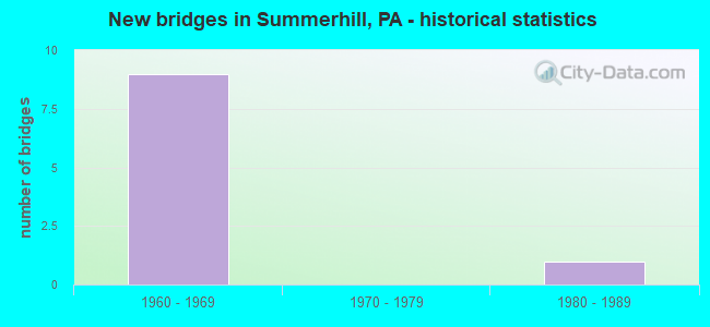
- New bridges - historical statistics
- 91960-1969
- 11980-1989

- Reconstructed bridges - Historical Statistics
- 32000-2009
- 42010-2019


- Bridge Condition - Deck
- 57.1%Good
- 42.9%Satisfactory

- Bridge Condition - Superstructure
- 42.9%Good
- 42.9%Satisfactory
- 14.3%Fair

- Bridge Condition - Substructure
- 28.6%Good
- 71.4%Satisfactory

- Bridge Condition - Channel
- 25.0%Good
- 75.0%Satisfactory
Find on map >> Show street view
Structure Number: 8366, Location: 0.8 MILE NORTH OF TR 219 (Lat: 40.374169, Lng: -78.757278), Route carried "on" structure: State highway 53, Year Built: 1965, Year Reconstructed: 2010, Status: Open, Structure Length: 1.01m (3.31ft), Average Daily Traffic: 3,615 (year 2020), Truck Traffic: 9%, Average Future Daily Traffic: 4,658 (year 2032), Design Load: HS 20, Features Intersected: LAUREL RUN
Minimum Vertical Clearance: 30+ m (98+ ft), Kilometerpoint: 1.334, Lanes on structure: 2, Base Highway Network: Yes, Owner: State Highway Agency, Approaching Roadway Width: 11.6m (38.1ft), Skew: 2 degrees, Material/Design: Prestressed concrete, Design/Construction: Box Beam or Girders - Multiple, Number Of Spans In Main Unit: 1, Length of Maximum Span: 9.8m (32.2ft), Curb or Sidewalk Widths: Left: 1.5m (4.9ft), Right: 0.0m, Curb-To-Curb Width: 12.2m (40.0ft), Out-to-Out Width: 14.9m (48.9ft)
Condition: Deck: Satisfactory, Superstructure: Good, Substructure: Satisfactory, Channel: Satisfactory, Operating Rating: 77.1 metric tons, Method Used To Determine Operating Rating: Load Factor (LF), Inventory Rating: 32.7 metric tons, Method Used To Determine Inventory Rating: Load Factor (LF), Structural Evaluation: Equal to present minimum criteria, Deck Geometry: Equal to present minimum criteria, Waterway Adequacy: Equal to present minimum criteria, Approach Roadway Alignment: Equal to present desirable criteria, Length Of Structure Improvement: 1.20m (3.94ft), Designated Inspection Frequency: Every 24 months, Inspection Date: Febuary 2021, Bridge Improvement Cost: $50,000, Roadway Improvement Cost: $264,000, Total Project Cost: $670,000, Deck Structure Type: Concrete Cast-file-Place, Wearing Surface/Protective System: Wearing Surface: Latex Concrete
Find on map >> Show street view
Structure Number: 8367, Location: 0.9 MILE NORTH OF TR 219 (Lat: 40.374950, Lng: -78.756400), Route carried "on" structure: State highway 53, Year Built: 1965, Year Reconstructed: 2011, Status: Open, Structure Length: 4.60m (15.09ft), Average Daily Traffic: 3,615 (year 2020), Truck Traffic: 9%, Average Future Daily Traffic: 4,658 (year 2032), Design Load: HS 20, Features Intersected: LITTLE CONEMAUGH RIVER
Minimum Vertical Clearance: 30+ m (98+ ft), Kilometerpoint: 1.334, Lanes on structure: 2, Base Highway Network: Yes, Owner: State Highway Agency, Approaching Roadway Width: 10.7m (35.1ft), Skew: 4 degrees, Material/Design: Prestressed concrete, Design/Construction: Stringer/Multi-beam, Number Of Spans In Main Unit: 2, Length of Maximum Span: 22.6m (74.1ft), Curb-To-Curb Width: 12.3m (40.4ft), Out-to-Out Width: 13.9m (45.6ft)
Condition: Deck: Good, Superstructure: Good, Substructure: Satisfactory, Channel: Satisfactory, Operating Rating: 83.5 metric tons, Method Used To Determine Operating Rating: Load Factor (LF), Inventory Rating: 18.1 metric tons, Method Used To Determine Inventory Rating: Load Factor (LF), Structural Evaluation: Somewhat better than minimum adequacy, Deck Geometry: Equal to present minimum criteria, Waterway Adequacy: Equal to present desirable criteria, Approach Roadway Alignment: Equal to present desirable criteria, Length Of Structure Improvement: 5.60m (18.37ft), Designated Inspection Frequency: Every 24 months, Inspection Date: August 2020, Bridge Improvement Cost: $141,000, Roadway Improvement Cost: $416,000, Total Project Cost: $1,907,000, Deck Structure Type: Concrete Cast-file-Place, Wearing Surface/Protective System: Wearing Surface: Latex Concrete
Find on map >> Show street view
Structure Number: 8368, Location: 1.3 MILE NORTH OF TR 219 (Lat: 40.376147, Lng: -78.749067), Route carried "on" structure: State highway 53, Year Built: 1965, Year Reconstructed: 2011, Status: Open, Structure Length: 7.13m (23.39ft), Average Daily Traffic: 3,475 (year 2020), Truck Traffic: 9%, Average Future Daily Traffic: 4,025 (year 2032), Design Load: HS 20, Features Intersected: LITTLE CONEMAUGH RIVER
Minimum Vertical Clearance: 30+ m (98+ ft), Kilometerpoint: 2.087, Lanes on structure: 2, Base Highway Network: Yes, Owner: State Highway Agency, Approaching Roadway Width: 9.8m (32.2ft), Skew: 1 degrees, Material/Design: Prestressed concrete, Design/Construction: Stringer/Multi-beam, Number Of Spans In Main Unit: 3, Length of Maximum Span: 29.9m (98.1ft), Curb or Sidewalk Widths: Left: 0.2m (0.7ft), Right: 0.2m (0.7ft), Curb-To-Curb Width: 9.8m (32.2ft), Out-to-Out Width: 11.4m (37.4ft)
Condition: Deck: Satisfactory, Superstructure: Fair, Substructure: Satisfactory, Channel: Good, Operating Rating: 76.2 metric tons, Method Used To Determine Operating Rating: Load Factor (LF), Inventory Rating: 14.5 metric tons, Method Used To Determine Inventory Rating: Load Factor (LF), Structural Evaluation: Meets minimum limits, Deck Geometry: Meets minimum limits, Waterway Adequacy: Superior to present desirable criteria, Approach Roadway Alignment: Equal to present desirable criteria, Length Of Structure Improvement: 7.10m (23.29ft), Designated Inspection Frequency: Every 24 months, Inspection Date: June 2020, Bridge Improvement Cost: $173,000, Roadway Improvement Cost: $510,000, Total Project Cost: $2,337,000, Deck Structure Type: Concrete Cast-file-Place, Wearing Surface/Protective System: Wearing Surface: Latex Concrete
Find on map >> Show street view
Structure Number: 8369, Location: 1.6 MILE NORTH OF US 219 (Lat: 40.376842, Lng: -78.742956), Route carried "on" structure: State highway 53, Year Built: 1965, Year Reconstructed: 2010, Status: Open, Structure Length: 7.59m (24.90ft), Average Daily Traffic: 3,475 (year 2020), Truck Traffic: 9%, Average Future Daily Traffic: 4,025 (year 2032), Design Load: HS 20, Features Intersected: LITTLE CONEMAUGH RIVER
Minimum Vertical Clearance: 30+ m (98+ ft), Kilometerpoint: 2.087, Lanes on structure: 2, Base Highway Network: Yes, Owner: State Highway Agency, Approaching Roadway Width: 11.0m (36.1ft), Skew: 3 degrees, Material/Design: Prestressed concrete, Design/Construction: Box Beam or Girders - Multiple, Number Of Spans In Main Unit: 1, Number Of Approach Spans: 2, Length of Maximum Span: 31.7m (104.0ft), Curb-To-Curb Width: 9.8m (32.2ft), Out-to-Out Width: 11.4m (37.4ft)
Condition: Deck: Satisfactory, Superstructure: Satisfactory, Substructure: Satisfactory, Channel: Satisfactory, Inventory Rating: 0.9 metric tons, Method Used To Determine Inventory Rating: Load Factor (LF), Structural Evaluation: High priority of corrective action, Deck Geometry: Meets minimum limits, Waterway Adequacy: Superior to present desirable criteria, Approach Roadway Alignment: Equal to present desirable criteria, Length Of Structure Improvement: 11.20m (36.75ft), Designated Inspection Frequency: Every 24 months, Inspection Date: June 2020, Bridge Improvement Cost: $117,000, Roadway Improvement Cost: $344,000, Total Project Cost: $1,576,000, Deck Structure Type: Concrete Cast-file-Place, Wearing Surface/Protective System: Wearing Surface: Integral Concrete, Deck Protection: Epoxy Coated Reinforcing
Find on map >> Show street view
Structure Number: 8463, Location: 0.8 MILE NORTH OF TR 53 (Lat: 40.377592, Lng: -78.763400), Route carried "on" structure: US 219, Year Built: 1968, Year Reconstructed: 2010, Status: Open, Structure Length: 4.54m (14.90ft), Average Daily Traffic: 13,218 (year 2020), Truck Traffic: 12%, Average Future Daily Traffic: 17,843 (year 2032), Design Load: HS 20, Features Intersected: SR 3043 (JACKSON ST)
Minimum Vertical Clearance: 30+ m (98+ ft), Kilometerpoint: 18.810, Lanes on structure: 2, Lanes under structure: 2, Base Highway Network: Yes, Owner: State Highway Agency, Approaching Roadway Width: 11.6m (38.1ft), Skew: 32 degrees, Material/Design: Steel continuous, Design/Construction: Stringer/Multi-beam, Number Of Spans In Main Unit: 3, Length of Maximum Span: 16.8m (55.1ft), Curb or Sidewalk Widths: Left: 0.2m (0.7ft), Right: 0.2m (0.7ft), Curb-To-Curb Width: 11.4m (37.4ft), Out-to-Out Width: 24.8m (81.4ft)
Condition: Deck: Good, Superstructure: Good, Substructure: Good, Operating Rating: 53.5 metric tons, Method Used To Determine Operating Rating: Load Factor (LF), Inventory Rating: 31.8 metric tons, Method Used To Determine Inventory Rating: Load Factor (LF), Structural Evaluation: Better than present minimum criteria, Deck Geometry: Meets minimum limits, Underclear: Meets minimum limits, Approach Roadway Alignment: Equal to present desirable criteria, Length Of Structure Improvement: 5.50m (18.04ft), Designated Inspection Frequency: Every 24 months, Inspection Date: April 2021, Deck Structure Type: Concrete Cast-file-Place, Wearing Surface/Protective System: Wearing Surface: Latex Concrete
Find on map >> Show street view
Structure Number: 8464, Location: T-417 AT SR 8019 (Lat: 40.408333, Lng: -78.760000), Route carried "on" structure: State highway , Year Built: 1965, Year Reconstructed: 2011, Status: Open, Structure Length: 8.78m (28.81ft), Average Daily Traffic: 651 (year 2020), Truck Traffic: 4%, Average Future Daily Traffic: 619 (year 2032), Design Load: HS 20, Features Intersected: US 219, Facility Carried by Structure: T417 TOWER ROAD
Minimum Vertical Clearance: 30+ m (98+ ft), Kilometerpoint: 0.000, Lanes on structure: 2, Lanes under structure: 4, Owner: State Highway Agency, Approaching Roadway Width: 8.8m (28.9ft), Material/Design: Prestressed concrete, Design/Construction: Box Beam or Girders - Single/Spread, Number Of Spans In Main Unit: 6, Length of Maximum Span: 17.1m (56.1ft), Curb or Sidewalk Widths: Left: 0.2m (0.7ft), Right: 0.2m (0.7ft), Curb-To-Curb Width: 9.1m (29.9ft), Out-to-Out Width: 10.2m (33.5ft)
Condition: Deck: Good, Superstructure: Satisfactory, Substructure: Satisfactory, Operating Rating: 68.0 metric tons, Method Used To Determine Operating Rating: Load Factor (LF), Inventory Rating: 27.2 metric tons, Method Used To Determine Inventory Rating: Load Factor (LF), Structural Evaluation: Equal to present minimum criteria, Deck Geometry: Equal to present minimum criteria, Underclear: Somewhat better than minimum adequacy, Approach Roadway Alignment: Equal to present desirable criteria, Length Of Structure Improvement: 10.90m (35.76ft), Designated Inspection Frequency: Every 24 months, Inspection Date: July 2021, Bridge Improvement Cost: $265,000, Roadway Improvement Cost: $781,000, Total Project Cost: $3,581,000, Deck Structure Type: Concrete Cast-file-Place, Wearing Surface/Protective System: Wearing Surface: Latex Concrete
Find on map >> Show street view
Structure Number: 8596, Location: SUMMERHILL BORO. (Lat: 40.374000, Lng: -78.761314), Route carried "on" structure: State highway , Year Built: 1984, Year Reconstructed: 2016, Status: Open, Structure Length: 4.48m (14.70ft), Average Daily Traffic: 2,159 (year 2022), Truck Traffic: 9%, Average Future Daily Traffic: 2,580 (year 2032), Design Load: HS 20+Mod, Features Intersected: NORFOLK SOUTHERN, Facility Carried by Structure: SR 2009
Minimum Vertical Clearance: 30+ m (98+ ft), Kilometerpoint: 0.000, Lanes on structure: 2, Owner: State Highway Agency, Approaching Roadway Width: 8.5m (27.9ft), Material/Design: Prestressed concrete, Design/Construction: Box Beam or Girders - Single/Spread, Number Of Spans In Main Unit: 3, Length of Maximum Span: 21.6m (70.9ft), Curb or Sidewalk Widths: Left: 1.5m (4.9ft), Right: 0.2m (0.7ft), Curb-To-Curb Width: 8.5m (27.9ft), Out-to-Out Width: 11.5m (37.7ft)
Condition: Deck: Good, Superstructure: Satisfactory, Substructure: Good, Operating Rating: 82.6 metric tons, Method Used To Determine Operating Rating: Load Factor (LF), Inventory Rating: 29.9 metric tons, Method Used To Determine Inventory Rating: Load Factor (LF), Structural Evaluation: Equal to present minimum criteria, Deck Geometry: Meets minimum limits, Underclear: High priority of corrective action, Approach Roadway Alignment: Somewhat better than minimum adequacy, Length Of Structure Improvement: 5.50m (18.04ft), Designated Inspection Frequency: Every 24 months, Inspection Date: October 2021, Deck Structure Type: Concrete Cast-file-Place, Wearing Surface/Protective System: Wearing Surface: Epoxy Overlay, Deck Protection: Epoxy Coated Reinforcing
Find on map >> Show street view
Structure Number: 8463, Location: 0.8 MILE NORTH OF TR 53 (Lat: 40.377592, Lng: -78.763400), Route carried "under" structure: State highway , Year Built: 1968, Structure Length: 0. m, Average Daily Traffic: 1,192 (year 2022), Truck Traffic: 9%, Features Intersected: SR 3043 (JACKSON ST), Facility Carried by Structure: US 219
Minimum Vertical Clearance: 4.33m (14.21ft), Kilometerpoint: 0.000, Lanes on structure: 2, Lanes under structure: 2, Material/Design: Steel continuous, Design/Construction: Stringer/Multi-beam, Length of Maximum Span: 16.8m (55.1ft)
Find on map >> Show street view
Structure Number: 8464, Location: T-417 AT SR 8019 (Lat: 40.408333, Lng: -78.760000), Route carried "under" structure: US 219, Year Built: 1965, Structure Length: 0. m, Average Daily Traffic: 6,308 (year 2020), Truck Traffic: 11%, Features Intersected: US 219, Facility Carried by Structure: T417 TOWER ROAD
Minimum Vertical Clearance: 5.00m (16.40ft), Kilometerpoint: 22.603, Lanes on structure: 2, Lanes under structure: 2, Material/Design: Prestressed concrete, Design/Construction: Box Beam or Girders - Single/Spread, Length of Maximum Span: 17.1m (56.1ft)
Find on map >> Show street view
Structure Number: 8464, Location: T-417 AT SR 8019 (Lat: 40.408333, Lng: -78.760000), Route carried "under" structure: US 219, Year Built: 1965, Structure Length: 0. m, Average Daily Traffic: 6,321 (year 2020), Truck Traffic: 9%, Features Intersected: US 219, Facility Carried by Structure: T417 TOWER ROAD
Minimum Vertical Clearance: 5.08m (16.67ft), Kilometerpoint: 22.594, Lanes on structure: 2, Lanes under structure: 2, Material/Design: Prestressed concrete, Design/Construction: Box Beam or Girders - Single/Spread, Length of Maximum Span: 17.1m (56.1ft)