Bridge Statistics for Sugar Grove, Pennsylvania (PA)
Condition, Traffic, Stress, Structural Evaluation, Project Costs
- National Bridge Inventory (NBI) Statistics
- 15Number of bridges
- 52ft / 16.2mTotal length
- $460,000Total costs
- 9,267Total average daily traffic
- 681Total average daily truck traffic
- 16,315Total future (year 2009) average daily traffic
- National Bridge Inventory (NBI) Registered Bridges for Sugar Grove
- No street view available for this location
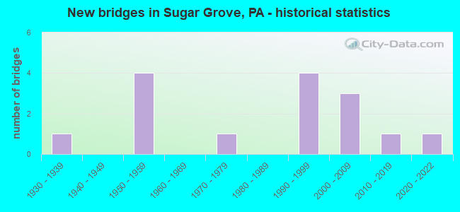
- New bridges - historical statistics
- 11930-1939
- 41950-1959
- 11970-1979
- 41990-1999
- 32000-2009
- 12010-2019
- 12020-2022

- Reconstructed bridges - Historical Statistics
- 11970-1979
- 11980-1989
- 01990-1999
- 12000-2009

- Bridge Condition - Deck
- 22.2%Very good
- 33.3%Good
- 44.4%Satisfactory

- Bridge Condition - Superstructure
- 22.2%Excellent
- 11.1%Very good
- 22.2%Good
- 22.2%Satisfactory
- 11.1%Fair
- 11.1%Poor

- Bridge Condition - Substructure
- 11.1%Excellent
- 22.2%Very good
- 22.2%Good
- 22.2%Satisfactory
- 22.2%Fair

- Bridge Condition - Channel
- 6.7%Very good
- 26.7%Good
- 33.3%Satisfactory
- 20.0%Fair
- 13.3%Poor

- Bridge Condition - Culverts
- 16.7%Very good
- 50.0%Good
- 16.7%Satisfactory
- 16.7%Fair
Find on map >> Show street view
Structure Number: 3421, Location: 500 feet west of T-392 (Lat: 40.889833, Lng: -79.648789), Route carried "on" structure: City street , Year Built: 1951, Year Reconstructed: 1981, Status: Open, Structure Length: 1.10m (3.61ft), Average Daily Traffic: 80 (year 2021), Truck Traffic: 9%, Average Future Daily Traffic: 112 (year 2041), Design Load: HS 20+Mod, Features Intersected: PATTERSON CREEK, Facility Carried by Structure: T-363 PUMP STATION
Minimum Vertical Clearance: 30+ m (98+ ft), Kilometerpoint: 0.000, Lanes on structure: 1, Owner: County Highway Agency, Approaching Roadway Width: 4.3m (14.1ft), Material/Design: Prestressed concrete, Design/Construction: Box Beam or Girders - Multiple, Number Of Spans In Main Unit: 1, Length of Maximum Span: 10.7m (35.1ft), Curb or Sidewalk Widths: Left: 0.1m (0.3ft), Right: 0.1m (0.3ft), Curb-To-Curb Width: 4.1m (13.5ft), Out-to-Out Width: 4.6m (15.1ft)
Condition: Deck: Satisfactory, Superstructure: Satisfactory, Substructure: Satisfactory, Channel: Satisfactory, Operating Rating: 72.6 metric tons, Method Used To Determine Operating Rating: Load Factor (LF), Inventory Rating: 36.3 metric tons, Method Used To Determine Inventory Rating: Load Factor (LF), Structural Evaluation: Equal to present minimum criteria, Deck Geometry: Somewhat better than minimum adequacy, Waterway Adequacy: Better than present minimum criteria, Approach Roadway Alignment: Meets minimum limits, Length Of Structure Improvement: 1.70m (5.58ft), Designated Inspection Frequency: Every 24 months, Inspection Date: April 2021, Deck Structure Type: Concrete Cast-file-Place, Wearing Surface/Protective System: Wearing Surface: Bituminous
Find on map >> Show street view
Structure Number: 34002, Location: SUGAR GROVE TOWNSHIP (Lat: 41.917275, Lng: -79.335525), Route carried "on" structure: State highway 27, Year Built: 1931, Status: Open, Structure Length: 0.98m (3.22ft), Average Daily Traffic: 1,223 (year 2020), Truck Traffic: 8%, Average Future Daily Traffic: 2,110 (year 2032), Design Load: HS 15, Features Intersected: OVER MATTHEWS RUN
Minimum Vertical Clearance: 30+ m (98+ ft), Kilometerpoint: 40.980, Lanes on structure: 2, Base Highway Network: Yes, Owner: State Highway Agency, Approaching Roadway Width: 6.1m (20.0ft), Skew: 3 degrees, Material/Design: Concrete, Design/Construction: Tee Beam, Number Of Spans In Main Unit: 1, Length of Maximum Span: 9.1m (29.9ft), Curb-To-Curb Width: 9.0m (29.5ft), Out-to-Out Width: 10.3m (33.8ft)
Condition: Deck: Satisfactory, Superstructure: Poor, Substructure: Fair, Channel: Satisfactory, Operating Rating: 49.0 metric tons, Method Used To Determine Operating Rating: Load Factor (LF), Inventory Rating: 25.4 metric tons, Method Used To Determine Inventory Rating: Load Factor (LF), Structural Evaluation: Meets minimum limits, Deck Geometry: Somewhat better than minimum adequacy, Waterway Adequacy: Equal to present minimum criteria, Approach Roadway Alignment: Equal to present desirable criteria, Length Of Structure Improvement: 1.60m (5.25ft), Designated Inspection Frequency: Every 24 months, Inspection Date: May 2021, Bridge Improvement Cost: $3,000, Roadway Improvement Cost: $15,000, Total Project Cost: $38,000, Wearing Surface/Protective System: Wearing Surface: Bituminous
Find on map >> Show street view
Structure Number: 3408, Location: SUGAR GROVE TOWNSHIP (Lat: 41.983156, Lng: -79.319669), Route carried "on" structure: State highway 957, Year Built: 1953, Year Reconstructed: 2006, Status: Open, Structure Length: 1.37m (4.49ft), Average Daily Traffic: 1,131 (year 2020), Truck Traffic: 10%, Average Future Daily Traffic: 3,402 (year 2032), Design Load: HL 93, Features Intersected: OVER STILLWATER CREEK
Minimum Vertical Clearance: 30+ m (98+ ft), Kilometerpoint: 23.960, Lanes on structure: 2, Owner: State Highway Agency, Approaching Roadway Width: 7.9m (25.9ft), Material/Design: Prestressed concrete, Design/Construction: Box Beam or Girders - Single/Spread, Number Of Spans In Main Unit: 1, Length of Maximum Span: 13.1m (43.0ft), Curb or Sidewalk Widths: Left: 0.2m (0.7ft), Right: 0.2m (0.7ft), Curb-To-Curb Width: 7.7m (25.3ft), Out-to-Out Width: 8.8m (28.9ft)
Condition: Deck: Good, Superstructure: Excellent, Substructure: Very good, Channel: Poor, Operating Rating: 65.3 metric tons, Method Used To Determine Operating Rating: Load Factor (LF), Inventory Rating: 43.5 metric tons, Method Used To Determine Inventory Rating: Load Factor (LF), Structural Evaluation: Equal to present desirable criteria, Deck Geometry: Meets minimum limits, Waterway Adequacy: Equal to present minimum criteria, Approach Roadway Alignment: Equal to present minimum criteria, Designated Inspection Frequency: Every 24 months, Underwater Inspection Frequency: Every 60 months, Inspection Date: June 2020, Underwater Inspection Date: July 2021, Deck Structure Type: Concrete Cast-file-Place, Wearing Surface/Protective System: Wearing Surface: Monolithic Concrete, Deck Protection: Epoxy Coated Reinforcing
Find on map >> Show street view
Structure Number: 34081, Location: SUGAR GROVE TOWNSHIP (Lat: 41.983203, Lng: -79.305892), Route carried "on" structure: State highway 957, Year Built: 1954, Status: Open, Structure Length: 1.28m (4.20ft), Average Daily Traffic: 1,131 (year 2020), Truck Traffic: 10%, Average Future Daily Traffic: 3,402 (year 2032), Design Load: HS 20, Features Intersected: OVER STILLWATER CREEK BR
Minimum Vertical Clearance: 30+ m (98+ ft), Kilometerpoint: 25.106, Lanes on structure: 2, Owner: State Highway Agency, Approaching Roadway Width: 8.2m (26.9ft), Skew: 4 degrees, Material/Design: Concrete, Design/Construction: Tee Beam, Number Of Spans In Main Unit: 1, Length of Maximum Span: 11.9m (39.0ft), Curb or Sidewalk Widths: Left: 0.1m (0.3ft), Right: 0.1m (0.3ft), Curb-To-Curb Width: 9.1m (29.9ft), Out-to-Out Width: 10.1m (33.1ft)
Condition: Deck: Satisfactory, Superstructure: Fair, Substructure: Fair, Channel: Fair, Operating Rating: 77.1 metric tons, Method Used To Determine Operating Rating: Load Factor (LF), Inventory Rating: 46.3 metric tons, Method Used To Determine Inventory Rating: Load Factor (LF), Structural Evaluation: Somewhat better than minimum adequacy, Deck Geometry: Somewhat better than minimum adequacy, Waterway Adequacy: Equal to present desirable criteria, Approach Roadway Alignment: Equal to present desirable criteria, Length Of Structure Improvement: 1.30m (4.27ft), Designated Inspection Frequency: Every 24 months, Inspection Date: May 2021, Bridge Improvement Cost: $21,000, Roadway Improvement Cost: $62,000, Total Project Cost: $285,000, Wearing Surface/Protective System: Wearing Surface: Bituminous, Membrane: Preformed Fabric
Find on map >> Show street view
Structure Number: 3421, Location: SUGAR GROVE TOWNSHIP (Lat: 41.907672, Lng: -79.351300), Route carried "on" structure: State highway , Year Built: 1959, Status: Open, Structure Length: 1.04m (3.41ft), Average Daily Traffic: 101 (year 2020), Truck Traffic: 6%, Average Future Daily Traffic: 130 (year 2032), Design Load: H 20, Features Intersected: OVER HAZELTINE HOLLW RUN, Facility Carried by Structure: SR 4011,HAZELTINE
Minimum Vertical Clearance: 30+ m (98+ ft), Kilometerpoint: 0.000, Lanes on structure: 2, Owner: State Highway Agency, Approaching Roadway Width: 6.1m (20.0ft), Skew: 3 degrees, Material/Design: Prestressed concrete, Design/Construction: Box Beam or Girders - Multiple, Number Of Spans In Main Unit: 1, Length of Maximum Span: 9.8m (32.2ft), Curb or Sidewalk Widths: Left: 0.2m (0.7ft), Right: 0.2m (0.7ft), Curb-To-Curb Width: 8.5m (27.9ft), Out-to-Out Width: 9.8m (32.2ft)
Condition: Deck: Satisfactory, Superstructure: Satisfactory, Substructure: Satisfactory, Channel: Satisfactory, Operating Rating: 49.0 metric tons, Method Used To Determine Operating Rating: Load Factor (LF), Inventory Rating: 32.7 metric tons, Method Used To Determine Inventory Rating: Load Factor (LF), Structural Evaluation: Equal to present minimum criteria, Deck Geometry: Equal to present minimum criteria, Waterway Adequacy: Better than present minimum criteria, Approach Roadway Alignment: Equal to present desirable criteria, Length Of Structure Improvement: 1.70m (5.58ft), Designated Inspection Frequency: Every 24 months, Inspection Date: April 2020, Deck Structure Type: Other, Wearing Surface/Protective System: Wearing Surface: Bituminous, Membrane: Preformed Fabric
Find on map >> Show street view
Structure Number: 34219, Location: SUGAR GROVE TOWNSHIP (Lat: 41.985603, Lng: -79.346114), Route carried "on" structure: State highway , Year Built: 1972, Year Reconstructed: 1980, Status: Open, Structure Length: 0.91m (2.99ft), Average Daily Traffic: 728 (year 2020), Truck Traffic: 6%, Average Future Daily Traffic: 889 (year 2032), Design Load: HS 20, Features Intersected: OVER STILLWATER CK BR, Facility Carried by Structure: SR 4019,E.MILL ST
Minimum Vertical Clearance: 30+ m (98+ ft), Kilometerpoint: 0.000, Lanes on structure: 2, Owner: State Highway Agency, Approaching Roadway Width: 5.5m (18.0ft), Material/Design: Steel, Design/Construction: Culvert, Number Of Spans In Main Unit: 2, Length of Maximum Span: 3.0m (9.8ft), Curb-To-Curb Width: 11.4m (37.4ft), Out-to-Out Width: 12.1m (39.7ft)
Condition: Channel: Satisfactory, Culverts: Good, Operating Rating: 54.4 metric tons, Method Used To Determine Operating Rating: Field evaluation and documented engineering judgment, Inventory Rating: 32.7 metric tons, Method Used To Determine Inventory Rating: Field evaluation and documented engineering judgment, Structural Evaluation: Better than present minimum criteria, Deck Geometry: Better than present minimum criteria, Waterway Adequacy: Better than present minimum criteria, Approach Roadway Alignment: Equal to present desirable criteria, Length Of Structure Improvement: 1.60m (5.25ft), Designated Inspection Frequency: Every 24 months, Inspection Date: January 2020
Find on map >> Show street view
Structure Number: 40132, Location: SUGAR GROVE TOWNSHIP (Lat: 41.984039, Lng: -79.369917), Route carried "on" structure: City street 7221, Year Built: 1997, Status: Open, Structure Length: 1.13m (3.71ft), Average Daily Traffic: 100 (year 2021), Truck Traffic: 5%, Average Future Daily Traffic: 140 (year 2041), Design Load: HS 25 or greater, Features Intersected: OVER STILLWATER CREEK, Facility Carried by Structure: T-539,STILLWATER R
Minimum Vertical Clearance: 30+ m (98+ ft), Kilometerpoint: 0.000, Lanes on structure: 2, Owner: Town or Township Highway Agency, Approaching Roadway Width: 5.8m (19.0ft), Skew: 2 degrees, Material/Design: Prestressed concrete, Design/Construction: Box Beam or Girders - Multiple, Number Of Spans In Main Unit: 1, Length of Maximum Span: 10.7m (35.1ft), Curb or Sidewalk Widths: Left: 0.2m (0.7ft), Right: 0.2m (0.7ft), Curb-To-Curb Width: 7.6m (24.9ft), Out-to-Out Width: 8.7m (28.5ft)
Condition: Deck: Very good, Superstructure: Good, Substructure: Good, Channel: Fair, Operating Rating: 74.4 metric tons, Method Used To Determine Operating Rating: Load Factor (LF), Inventory Rating: 39.0 metric tons, Method Used To Determine Inventory Rating: Load Factor (LF), Structural Evaluation: Better than present minimum criteria, Deck Geometry: Equal to present minimum criteria, Waterway Adequacy: Equal to present desirable criteria, Approach Roadway Alignment: Equal to present desirable criteria, Length Of Structure Improvement: 1.80m (5.91ft), Designated Inspection Frequency: Every 24 months, Inspection Date: October 2021, Deck Structure Type: Other, Wearing Surface/Protective System: Wearing Surface: Bituminous, Membrane: Other, Deck Protection: Epoxy Coated Reinforcing
Find on map >> Show street view
Structure Number: 40134, Location: SUGARGROVE BOROUGH (Lat: 41.980325, Lng: -79.340689), Route carried "on" structure: City street 7403, Year Built: 1997, Status: Open, Structure Length: 1.55m (5.09ft), Average Daily Traffic: 400 (year 2005), Average Future Daily Traffic: 560 (year 2029), Design Load: HS 25 or greater, Features Intersected: OVER STILLWATER CREEK, Facility Carried by Structure: SCHOOL STREET
Minimum Vertical Clearance: 30+ m (98+ ft), Kilometerpoint: 0.000, Lanes on structure: 2, Owner: Town or Township Highway Agency, Approaching Roadway Width: 7.3m (24.0ft), Material/Design: Prestressed concrete, Design/Construction: Box Beam or Girders - Multiple, Number Of Spans In Main Unit: 1, Length of Maximum Span: 15.2m (49.9ft), Curb or Sidewalk Widths: Left: 0.2m (0.7ft), Right: 0.2m (0.7ft), Curb-To-Curb Width: 7.6m (24.9ft), Out-to-Out Width: 8.6m (28.2ft)
Condition: Deck: Good, Superstructure: Good, Substructure: Very good, Channel: Good, Operating Rating: 67.1 metric tons, Method Used To Determine Operating Rating: Load Factor (LF), Inventory Rating: 15.4 metric tons, Method Used To Determine Inventory Rating: Load Factor (LF), Structural Evaluation: Meets minimum limits, Deck Geometry: Somewhat better than minimum adequacy, Waterway Adequacy: Better than present minimum criteria, Approach Roadway Alignment: Equal to present desirable criteria, Length Of Structure Improvement: 2.20m (7.22ft), Designated Inspection Frequency: Every 24 months, Inspection Date: August 2021, Deck Structure Type: Other, Wearing Surface/Protective System: Wearing Surface: Bituminous, Membrane: Other, Deck Protection: Epoxy Coated Reinforcing
Find on map >> Show street view
Structure Number: 40556, Location: SUGAR GROVE BOROUGH (Lat: 41.984844, Lng: -79.336178), Route carried "on" structure: State highway , Year Built: 1999, Status: Open, Structure Length: 0.64m (2.10ft), Average Daily Traffic: 1,792 (year 2020), Truck Traffic: 7%, Average Future Daily Traffic: 3,013 (year 2032), Design Load: HS 25 or greater, Features Intersected: OVER BRANDS RUN, Facility Carried by Structure: SR 4021,JAMESTOWN
Minimum Vertical Clearance: 30+ m (98+ ft), Kilometerpoint: 0.000, Lanes on structure: 2, Base Highway Network: Yes, Owner: State Highway Agency, Approaching Roadway Width: 7.9m (25.9ft), Skew: 4 degrees, Material/Design: Concrete, Design/Construction: Culvert, Number Of Spans In Main Unit: 1, Length of Maximum Span: 6.4m (21.0ft), Curb-To-Curb Width: 12.8m (42.0ft), Out-to-Out Width: 26.7m (87.6ft)
Condition: Channel: Good, Culverts: Good, Inventory Rating: 60.8 metric tons, Method Used To Determine Inventory Rating: Load Factor (LF), Structural Evaluation: Better than present minimum criteria, Deck Geometry: Better than present minimum criteria, Waterway Adequacy: Equal to present minimum criteria, Approach Roadway Alignment: Equal to present desirable criteria, Length Of Structure Improvement: 1.20m (3.94ft), Designated Inspection Frequency: Every 48 months, Inspection Date: December 2019, Wearing Surface/Protective System: Wearing Surface: Bituminous, Membrane: Preformed Fabric, Deck Protection: Epoxy Coated Reinforcing
Find on map >> Show street view
Structure Number: 40693, Location: SUGAR GROVE TOWNSHIP (Lat: 41.906917, Lng: -79.342975), Route carried "on" structure: City street 7221, Year Built: 1998, Status: Open, Structure Length: 0.67m (2.20ft), Average Daily Traffic: 80 (year 2021), Truck Traffic: 1%, Average Future Daily Traffic: 112 (year 2041), Design Load: HS 25 or greater, Features Intersected: OVER MATTHEWS RUN, Facility Carried by Structure: T-569,FIDDLER HILL
Minimum Vertical Clearance: 30+ m (98+ ft), Kilometerpoint: 0.000, Lanes on structure: 2, Owner: Town or Township Highway Agency, Approaching Roadway Width: 6.1m (20.0ft), Material/Design: Steel, Design/Construction: Culvert, Number Of Spans In Main Unit: 2, Length of Maximum Span: 3.0m (9.8ft)
Condition: Channel: Poor, Culverts: Fair, Operating Rating: 80.7 metric tons, Method Used To Determine Operating Rating: Load Factor (LF), Inventory Rating: 53.5 metric tons, Method Used To Determine Inventory Rating: Load Factor (LF), Structural Evaluation: Somewhat better than minimum adequacy, Waterway Adequacy: Better than present minimum criteria, Approach Roadway Alignment: Equal to present desirable criteria, Length Of Structure Improvement: 1.30m (4.27ft), Designated Inspection Frequency: Every 24 months, Inspection Date: October 2021
Find on map >> Show street view
Structure Number: 41323, Location: SUGAR GROVE TOWNSHIP (Lat: 41.929342, Lng: -79.344742), Route carried "on" structure: City street 7221, Year Built: 2000, Status: Open, Structure Length: 0.73m (2.40ft), Average Daily Traffic: 100 (year 2021), Truck Traffic: 3%, Average Future Daily Traffic: 140 (year 2041), Design Load: HS 25 or greater, Features Intersected: OVER PATCHEN RUN, Facility Carried by Structure: T-453, DEER RUN RD
Minimum Vertical Clearance: 30+ m (98+ ft), Kilometerpoint: 0.000, Lanes on structure: 2, Owner: Town or Township Highway Agency, Approaching Roadway Width: 6.1m (20.0ft), Material/Design: Steel, Design/Construction: Culvert, Number Of Spans In Main Unit: 3, Length of Maximum Span: 2.4m (7.9ft)
Condition: Channel: Fair, Culverts: Satisfactory, Operating Rating: 89.8 metric tons, Method Used To Determine Operating Rating: Allowable Stress (AS), Inventory Rating: 70.8 metric tons, Method Used To Determine Inventory Rating: Allowable Stress (AS), Structural Evaluation: Equal to present minimum criteria, Waterway Adequacy: Equal to present desirable criteria, Approach Roadway Alignment: Equal to present desirable criteria, Length Of Structure Improvement: 0.90m (2.95ft), Designated Inspection Frequency: Every 24 months, Inspection Date: October 2021
Find on map >> Show street view
Structure Number: 41324, Location: SUGAR GROVE TOWNSHIP (Lat: 41.939122, Lng: -79.358386), Route carried "on" structure: City street 7221, Year Built: 2000, Status: Open, Structure Length: 1.07m (3.51ft), Average Daily Traffic: 100 (year 2021), Truck Traffic: 5%, Average Future Daily Traffic: 140 (year 2041), Design Load: HS 20, Features Intersected: OVER PATCHEN RUN, Facility Carried by Structure: T-453, DEER RUN RD
Minimum Vertical Clearance: 30+ m (98+ ft), Kilometerpoint: 0.000, Lanes on structure: 2, Owner: Town or Township Highway Agency, Approaching Roadway Width: 6.1m (20.0ft), Skew: 4 degrees, Material/Design: Steel, Design/Construction: Culvert, Number Of Spans In Main Unit: 3, Length of Maximum Span: 3.0m (9.8ft)
Condition: Channel: Satisfactory, Culverts: Good, Operating Rating: 50.8 metric tons, Method Used To Determine Operating Rating: Allowable Stress (AS), Inventory Rating: 35.4 metric tons, Method Used To Determine Inventory Rating: Allowable Stress (AS), Structural Evaluation: Better than present minimum criteria, Waterway Adequacy: Equal to present desirable criteria, Approach Roadway Alignment: Equal to present desirable criteria, Length Of Structure Improvement: 1.10m (3.61ft), Designated Inspection Frequency: Every 24 months, Inspection Date: October 2021, Bridge Improvement Cost: $10,000, Roadway Improvement Cost: $58,000, Total Project Cost: $137,000
Find on map >> Show street view
Structure Number: 44163, Location: SUGARGROVE BOROUGH (Lat: 41.982108, Lng: -79.342367), Route carried "on" structure: State highway 69, Year Built: 2007, Status: Open, Structure Length: 1.46m (4.79ft), Average Daily Traffic: 2,051 (year 2022), Truck Traffic: 8%, Average Future Daily Traffic: 1,845 (year 2032), Design Load: HL 93, Features Intersected: STILLWATER CREEK
Minimum Vertical Clearance: 30+ m (98+ ft), Kilometerpoint: 21.063, Lanes on structure: 2, Base Highway Network: Yes, Owner: State Highway Agency, Approaching Roadway Width: 12.8m (42.0ft), Skew: 1 degrees, Material/Design: Prestressed concrete, Design/Construction: Box Beam or Girders - Single/Spread, Number Of Spans In Main Unit: 1, Length of Maximum Span: 14.0m (45.9ft), Curb or Sidewalk Widths: Left: 1.2m (3.9ft), Right: 1.2m (3.9ft), Curb-To-Curb Width: 14.9m (48.9ft), Out-to-Out Width: 18.0m (59.1ft)
Condition: Deck: Good, Superstructure: Very good, Substructure: Good, Channel: Very good, Operating Rating: 52.6 metric tons, Method Used To Determine Operating Rating: Load and Resistance Factor (LRFR), Inventory Rating: 38.1 metric tons, Method Used To Determine Inventory Rating: Load and Resistance Factor (LRFR), Structural Evaluation: Better than present minimum criteria, Deck Geometry: Superior to present desirable criteria, Waterway Adequacy: Equal to present minimum criteria, Approach Roadway Alignment: Equal to present desirable criteria, Designated Inspection Frequency: Every 24 months, Inspection Date: November 2021, Deck Structure Type: Concrete Cast-file-Place, Wearing Surface/Protective System: Wearing Surface: Monolithic Concrete, Deck Protection: Epoxy Coated Reinforcing
Find on map >> Show street view
Structure Number: 57087, Location: SUGAR GROVE TOWNSHIP (Lat: 41.976978, Lng: -79.331511), Route carried "on" structure: City street 7221, Year Built: 2019, Status: Open, Structure Length: 0.73m (2.40ft), Average Daily Traffic: 150 (year 2005), Average Future Daily Traffic: 210 (year 2009), Design Load: HL 93, Features Intersected: OVER STILLWATER CREEK, Facility Carried by Structure: T-458,JONES HILL R
Minimum Vertical Clearance: 30+ m (98+ ft), Kilometerpoint: 0.000, Lanes on structure: 2, Owner: Town or Township Highway Agency, Approaching Roadway Width: 6.7m (22.0ft), Skew: 1 degrees, Material/Design: Concrete, Design/Construction: Culvert, Number Of Spans In Main Unit: 1, Length of Maximum Span: 7.3m (24.0ft), Curb-To-Curb Width: 7.3m (24.0ft), Out-to-Out Width: 9.6m (31.5ft)
Condition: Channel: Good, Culverts: Very good, Operating Rating: 54.1 metric tons, Method Used To Determine Operating Rating: Assigned ratings based on Load and Resistance Factor Design (LRFD) reported by rating factor (RF) using HL93 loadings, Inventory Rating: 34.0 metric tons, Method Used To Determine Inventory Rating: Assigned ratings based on Load and Resistance Factor Design (LRFD) reported by rating factor (RF) using HL93 loadings, Structural Evaluation: Equal to present desirable criteria, Deck Geometry: Somewhat better than minimum adequacy, Waterway Adequacy: Equal to present desirable criteria, Approach Roadway Alignment: Equal to present desirable criteria, Designated Inspection Frequency: Every 24 months, Inspection Date: September 2021, Wearing Surface/Protective System: Wearing Surface: Bituminous, Membrane: Preformed Fabric, Deck Protection: Epoxy Coated Reinforcing
Find on map >> Show street view
Structure Number: 68314, Location: SUGAR GROVE TOWNSHIP (Lat: 41.995600, Lng: -79.315300), Route carried "on" structure: City street 7221, Year Built: 2020, Status: Posted for load-capacity, Structure Length: 1.52m (4.99ft), Average Daily Traffic: 100 (year 2021), Average Future Daily Traffic: 110 (year 2041), Design Load: HL 93, Features Intersected: Stillwater Creek, Facility Carried by Structure: T-590,STODDARD RD.
Minimum Vertical Clearance: 30+ m (98+ ft), Kilometerpoint: 0.000, Lanes on structure: 2, Owner: Town or Township Highway Agency, Approaching Roadway Width: 4.3m (14.1ft), Material/Design: Steel, Design/Construction: Stringer/Multi-beam, Number Of Spans In Main Unit: 1, Length of Maximum Span: 14.6m (47.9ft), Curb-To-Curb Width: 6.1m (20.0ft), Out-to-Out Width: 6.1m (20.0ft)
Condition: Deck: Very good, Superstructure: Excellent, Substructure: Excellent, Channel: Good, Operating Rating: 15.0 metric tons, Method Used To Determine Operating Rating: Load and Resistance Factor (LRFR), Inventory Rating: 10.0 metric tons, Method Used To Determine Inventory Rating: Load and Resistance Factor (LRFR), Structural Evaluation: High priority of corrective action, Deck Geometry: Somewhat better than minimum adequacy, Waterway Adequacy: Better than present minimum criteria, Approach Roadway Alignment: Equal to present desirable criteria, Designated Inspection Frequency: Every 24 months, Other Special Inspection Frequency: Every 12 months, Inspection Date: June 2021, Deck Structure Type: Wood or Timber, Wearing Surface/Protective System: Wearing Surface: Wood or Timber