Bridge Statistics for Sudlersville, Maryland (MD)
Condition, Traffic, Stress, Structural Evaluation, Project Costs
- National Bridge Inventory (NBI) Statistics
- 15Number of bridges
- 92ft / 27.6mTotal length
- $197,000Total costs
- 47,581Total average daily traffic
- 3,774Total average daily truck traffic
- National Bridge Inventory (NBI) Registered Bridges for Sudlersville
- No street view available for this location
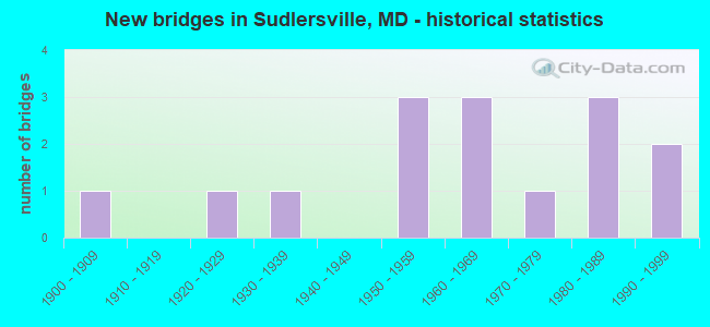
- New bridges - historical statistics
- 11900-1909
- 11920-1929
- 11930-1939
- 31950-1959
- 31960-1969
- 11970-1979
- 31980-1989
- 21990-1999

- Reconstructed bridges - Historical Statistics
- 11950-1959
- 01960-1969
- 01970-1979
- 01980-1989
- 01990-1999
- 02000-2009
- 22010-2019


- Bridge Condition - Deck
- 11.1%Very good
- 22.2%Good
- 66.7%Satisfactory

- Bridge Condition - Superstructure
- 33.3%Good
- 66.7%Satisfactory

- Bridge Condition - Substructure
- 11.1%Good
- 88.9%Satisfactory

- Bridge Condition - Channel
- 27.3%Very good
- 18.2%Good
- 54.5%Satisfactory

- Bridge Condition - Culverts
- 50.0%Good
- 25.0%Satisfactory
- 25.0%Fair
Find on map >> Show street view
Structure Number: 100000170011011, Location: 2.17 MILES N OF MD 300 (Lat: 39.199611, Lng: -75.900867), Route carried "on" structure: US 301, Year Built: 1955, Year Reconstructed: 2017, Status: Open, Structure Length: 4.29m (14.07ft), Average Daily Traffic: 5,500 (year 2012), Truck Traffic: 8%, Average Future Daily Traffic: 7,500 (year 2031), Design Load: HS 20, Features Intersected: MD 290
Minimum Vertical Clearance: 30+ m (98+ ft), Kilometerpoint: 55.605, Lanes on structure: 2, Lanes under structure: 2, Base Highway Network: Yes, Owner: State Highway Agency, Approaching Roadway Width: 13.4m (44.0ft), Material/Design: Steel, Design/Construction: Stringer/Multi-beam, Number Of Spans In Main Unit: 3, Length of Maximum Span: 14.3m (46.9ft), Curb-To-Curb Width: 10.2m (33.5ft), Out-to-Out Width: 11.2m (36.7ft)
Condition: Deck: Good, Superstructure: Good, Substructure: Good, Inventory Rating: 77.5 metric tons, Method Used To Determine Inventory Rating: Load Factor (LF), Structural Evaluation: Better than present minimum criteria, Deck Geometry: Somewhat better than minimum adequacy, Underclear: Equal to present minimum criteria, Approach Roadway Alignment: Equal to present desirable criteria, Designated Inspection Frequency: Every 24 months, Inspection Date: November 2020, Deck Structure Type: Concrete Cast-file-Place, Wearing Surface/Protective System: Wearing Surface: Monolithic Concrete
Find on map >> Show street view
Structure Number: 100000170011012, Location: 2.17 MILES N OF MD 300 (Lat: 39.200006, Lng: -75.900631), Route carried "on" structure: US 301, Year Built: 1967, Status: Open, Structure Length: 4.27m (14.01ft), Average Daily Traffic: 10,370 (year 2009), Truck Traffic: 8%, Average Future Daily Traffic: 6,716 (year 2026), Design Load: HS 20, Features Intersected: MD 290
Minimum Vertical Clearance: 30+ m (98+ ft), Kilometerpoint: 55.605, Lanes on structure: 2, Lanes under structure: 2, Base Highway Network: Yes, Owner: State Highway Agency, Approaching Roadway Width: 13.4m (44.0ft), Material/Design: Steel, Design/Construction: Stringer/Multi-beam, Number Of Spans In Main Unit: 3, Length of Maximum Span: 14.3m (46.9ft), Curb-To-Curb Width: 11.7m (38.4ft), Out-to-Out Width: 12.8m (42.0ft)
Condition: Deck: Satisfactory, Superstructure: Satisfactory, Substructure: Satisfactory, Operating Rating: 64.9 metric tons, Method Used To Determine Operating Rating: Load Factor (LF), Inventory Rating: 39.0 metric tons, Method Used To Determine Inventory Rating: Load Factor (LF), Structural Evaluation: Equal to present minimum criteria, Deck Geometry: Better than present minimum criteria, Underclear: Equal to present minimum criteria, Approach Roadway Alignment: Equal to present desirable criteria, Designated Inspection Frequency: Every 24 months, Inspection Date: November 2020, Deck Structure Type: Concrete Cast-file-Place, Wearing Surface/Protective System: Wearing Surface: Bituminous
Find on map >> Show street view
Structure Number: 100000170012011, Location: 0.27 MILE NORTH OF MD 290 (Lat: 39.201564, Lng: -75.896519), Route carried "on" structure: US 301, Year Built: 1955, Year Reconstructed: 2017, Status: Open, Structure Length: 2.87m (9.42ft), Average Daily Traffic: 5,500 (year 2012), Truck Traffic: 8%, Average Future Daily Traffic: 7,500 (year 2031), Design Load: HS 20, Features Intersected: RED LION BRANCH
Minimum Vertical Clearance: 30+ m (98+ ft), Kilometerpoint: 56.037, Lanes on structure: 2, Base Highway Network: Yes, Owner: State Highway Agency, Approaching Roadway Width: 13.4m (44.0ft), Material/Design: Steel, Design/Construction: Stringer/Multi-beam, Number Of Spans In Main Unit: 3, Length of Maximum Span: 8.8m (28.9ft), Curb-To-Curb Width: 11.9m (39.0ft), Out-to-Out Width: 12.9m (42.3ft)
Condition: Deck: Very good, Superstructure: Satisfactory, Substructure: Satisfactory, Channel: Very good, Inventory Rating: 75.7 metric tons, Method Used To Determine Inventory Rating: Load Factor (LF), Structural Evaluation: Equal to present minimum criteria, Deck Geometry: Better than present minimum criteria, Waterway Adequacy: Superior to present desirable criteria, Approach Roadway Alignment: Equal to present desirable criteria, Designated Inspection Frequency: Every 24 months, Inspection Date: April 2020, Deck Structure Type: Concrete Cast-file-Place, Wearing Surface/Protective System: Wearing Surface: Monolithic Concrete
Find on map >> Show street view
Structure Number: 100000170012012, Location: 0.27 MILE NORTH OF MD 290 (Lat: 39.201986, Lng: -75.896267), Route carried "on" structure: US 301, Year Built: 1967, Status: Open, Structure Length: 2.83m (9.28ft), Average Daily Traffic: 10,370 (year 2009), Truck Traffic: 8%, Average Future Daily Traffic: 6,716 (year 2026), Design Load: HS 20, Features Intersected: RED LION BRANCH
Minimum Vertical Clearance: 30+ m (98+ ft), Kilometerpoint: 56.037, Lanes on structure: 2, Base Highway Network: Yes, Owner: State Highway Agency, Approaching Roadway Width: 11.6m (38.1ft), Material/Design: Steel, Design/Construction: Stringer/Multi-beam, Number Of Spans In Main Unit: 3, Length of Maximum Span: 9.1m (29.9ft), Curb-To-Curb Width: 11.7m (38.4ft), Out-to-Out Width: 12.8m (42.0ft)
Condition: Deck: Satisfactory, Superstructure: Satisfactory, Substructure: Satisfactory, Channel: Very good, Operating Rating: 54.0 metric tons, Method Used To Determine Operating Rating: Load Factor (LF), Inventory Rating: 32.2 metric tons, Method Used To Determine Inventory Rating: Load Factor (LF), Structural Evaluation: Equal to present minimum criteria, Deck Geometry: Better than present minimum criteria, Waterway Adequacy: Equal to present desirable criteria, Approach Roadway Alignment: Equal to present desirable criteria, Designated Inspection Frequency: Every 24 months, Inspection Date: April 2020, Deck Structure Type: Concrete Cast-file-Place, Wearing Surface/Protective System: Wearing Surface: Bituminous
Find on map >> Show street view
Structure Number: 10000017002301, Location: 0.21 MILE SOUTH OF US 301 (Lat: 39.197347, Lng: -75.898622), Route carried "on" structure: State highway 290, Year Built: 1900, Year Reconstructed: 1956, Status: Open, Structure Length: 1.22m (4.00ft), Average Daily Traffic: 2,182 (year 2010), Truck Traffic: 8%, Average Future Daily Traffic: 2,595 (year 2026), Design Load: H 20, Features Intersected: RED LION BRANCH
Minimum Vertical Clearance: 30+ m (98+ ft), Kilometerpoint: 1.617, Lanes on structure: 2, Owner: State Highway Agency, Approaching Roadway Width: 13.4m (44.0ft), Material/Design: Concrete, Design/Construction: Culvert, Number Of Spans In Main Unit: 2, Length of Maximum Span: 5.5m (18.0ft), Curb-To-Curb Width: 14.6m (47.9ft), Out-to-Out Width: 15.2m (49.9ft)
Condition: Channel: Satisfactory, Culverts: Fair, Operating Rating: 41.3 metric tons, Method Used To Determine Operating Rating: Load Factor (LF), Inventory Rating: 24.5 metric tons, Method Used To Determine Inventory Rating: Load Factor (LF), Structural Evaluation: Somewhat better than minimum adequacy, Deck Geometry: Superior to present desirable criteria, Waterway Adequacy: Superior to present desirable criteria, Approach Roadway Alignment: Equal to present desirable criteria, Designated Inspection Frequency: Every 24 months, Inspection Date: July 2020, Deck Structure Type: Concrete Cast-file-Place, Wearing Surface/Protective System: Wearing Surface: Bituminous
Find on map >> Show street view
Structure Number: 10000017002401, Location: 0.09 MILE WEST OF MD 290 (Lat: 39.184169, Lng: -75.894078), Route carried "on" structure: State highway 300, Year Built: 1920, Status: Open, Structure Length: 1.52m (4.99ft), Average Daily Traffic: 2,391 (year 2018), Truck Traffic: 8%, Average Future Daily Traffic: 2,399 (year 2038), Features Intersected: RED LION BRANCH
Minimum Vertical Clearance: 30+ m (98+ ft), Kilometerpoint: 2.430, Lanes on structure: 2, Base Highway Network: Yes, Owner: State Highway Agency, Approaching Roadway Width: 12.8m (42.0ft), Material/Design: Concrete, Design/Construction: Slab, Number Of Spans In Main Unit: 3, Length of Maximum Span: 4.6m (15.1ft), Curb-To-Curb Width: 7.3m (24.0ft), Out-to-Out Width: 7.9m (25.9ft)
Condition: Deck: Satisfactory, Superstructure: Satisfactory, Substructure: Satisfactory, Channel: Satisfactory, Operating Rating: 56.7 metric tons, Method Used To Determine Operating Rating: Load Factor (LF), Inventory Rating: 34.0 metric tons, Method Used To Determine Inventory Rating: Load Factor (LF), Structural Evaluation: Equal to present minimum criteria, Deck Geometry: High priority of replacement, Waterway Adequacy: Superior to present desirable criteria, Approach Roadway Alignment: Equal to present desirable criteria, Length Of Structure Improvement: 1.52m (4.99ft), Designated Inspection Frequency: Every 24 months, Inspection Date: October 2020, Bridge Improvement Cost: $78,000, Roadway Improvement Cost: $8,000, Total Project Cost: $86,000, Deck Structure Type: Concrete Cast-file-Place, Wearing Surface/Protective System: Wearing Surface: Bituminous
Find on map >> Show street view
Structure Number: 10000017002501, Location: 1.4 MILES EAST OF MD 313 (Lat: 39.191181, Lng: -75.833903), Route carried "on" structure: State highway 300, Year Built: 1939, Status: Open, Structure Length: 1.68m (5.51ft), Average Daily Traffic: 2,461 (year 2018), Truck Traffic: 9%, Average Future Daily Traffic: 2,469 (year 2038), Design Load: H 20, Features Intersected: UNICORN BRANCH
Minimum Vertical Clearance: 30+ m (98+ ft), Kilometerpoint: 7.743, Lanes on structure: 2, Base Highway Network: Yes, Owner: State Highway Agency, Approaching Roadway Width: 12.8m (42.0ft), Skew: 2 degrees, Material/Design: Wood or Timber, Design/Construction: Stringer/Multi-beam, Number Of Spans In Main Unit: 3, Length of Maximum Span: 5.5m (18.0ft), Curb-To-Curb Width: 7.9m (25.9ft), Out-to-Out Width: 9.4m (30.8ft)
Condition: Deck: Satisfactory, Superstructure: Satisfactory, Substructure: Satisfactory, Channel: Very good, Operating Rating: 64.4 metric tons, Method Used To Determine Operating Rating: Load Factor (LF), Inventory Rating: 44.0 metric tons, Method Used To Determine Inventory Rating: Load Factor (LF), Structural Evaluation: Equal to present minimum criteria, Deck Geometry: High priority of corrective action, Waterway Adequacy: Superior to present desirable criteria, Approach Roadway Alignment: Equal to present desirable criteria, Length Of Structure Improvement: 1.68m (5.51ft), Designated Inspection Frequency: Every 24 months, Inspection Date: August 2021, Bridge Improvement Cost: $101,000, Roadway Improvement Cost: $10,000, Total Project Cost: $111,000, Deck Structure Type: Concrete Cast-file-Place, Wearing Surface/Protective System: Wearing Surface: Bituminous
Find on map >> Show street view
Structure Number: 10000017003801, Location: 0.56 MILE EAST OF MD 290 (Lat: 39.235178, Lng: -75.903947), Route carried "on" structure: State highway 544, Year Built: 1972, Status: Open, Structure Length: 2.62m (8.60ft), Average Daily Traffic: 1,551 (year 2009), Truck Traffic: 8%, Average Future Daily Traffic: 2,261 (year 2026), Design Load: HS 20, Features Intersected: RED LION BRANCH
Minimum Vertical Clearance: 30+ m (98+ ft), Kilometerpoint: 12.148, Lanes on structure: 2, Owner: State Highway Agency, Approaching Roadway Width: 13.4m (44.0ft), Skew: 1 degrees, Material/Design: Wood or Timber, Design/Construction: Stringer/Multi-beam, Number Of Spans In Main Unit: 5, Length of Maximum Span: 5.2m (17.1ft), Curb-To-Curb Width: 13.4m (44.0ft), Out-to-Out Width: 14.4m (47.2ft)
Condition: Deck: Satisfactory, Superstructure: Good, Substructure: Satisfactory, Channel: Satisfactory, Operating Rating: 66.2 metric tons, Method Used To Determine Operating Rating: Allowable Stress (AS), Inventory Rating: 41.7 metric tons, Method Used To Determine Inventory Rating: Allowable Stress (AS), Structural Evaluation: Equal to present minimum criteria, Deck Geometry: Equal to present desirable criteria, Waterway Adequacy: Equal to present desirable criteria, Approach Roadway Alignment: Equal to present desirable criteria, Designated Inspection Frequency: Every 24 months, Underwater Inspection Frequency: Every 48 months, Inspection Date: December 2020, Underwater Inspection Date: March 2020, Deck Structure Type: Wood or Timber, Wearing Surface/Protective System: Wearing Surface: Monolithic Concrete
Find on map >> Show street view
Structure Number: 200000Q-000403, Location: .84 MI. NE OF MD 290 (Lat: 39.219861, Lng: -75.899833), Route carried "on" structure: County highway 386, Year Built: 1984, Status: Open, Structure Length: 1.92m (6.30ft), Average Daily Traffic: 1,100 (year 2010), Truck Traffic: 5%, Average Future Daily Traffic: 1,300 (year 2032), Design Load: HS 20, Features Intersected: RED LION BRANCH, Facility Carried by Structure: RED LION BRANCH RD
Minimum Vertical Clearance: 30+ m (98+ ft), Kilometerpoint: 3.540, Lanes on structure: 2, Owner: County Highway Agency, Approaching Roadway Width: 9.1m (29.9ft), Material/Design: Aluminum, Iron, Design/Construction: Culvert, Length of Maximum Span: 4.3m (14.1ft)
Condition: Channel: Good, Culverts: Good, Inventory Rating: 66.2 metric tons, Method Used To Determine Inventory Rating: Load Factor (LF), Structural Evaluation: Better than present minimum criteria, Waterway Adequacy: Better than present minimum criteria, Approach Roadway Alignment: Better than present minimum criteria, Designated Inspection Frequency: Every 24 months, Inspection Date: May 2020
Find on map >> Show street view
Structure Number: 200000Q-000501, Location: 0.3 MI. NE OF MD 290 (Lat: 39.201528, Lng: -75.896083), Route carried "on" structure: County highway 43, Year Built: 1994, Status: Open, Structure Length: 1.34m (4.40ft), Average Daily Traffic: 100 (year 2010), Truck Traffic: 5%, Average Future Daily Traffic: 399 (year 2032), Design Load: HS 20, Features Intersected: RED LION BRANCH, Facility Carried by Structure: COLEMAN ROAD
Minimum Vertical Clearance: 30+ m (98+ ft), Kilometerpoint: 2.928, Lanes on structure: 2, Owner: County Highway Agency, Approaching Roadway Width: 7.3m (24.0ft), Material/Design: Wood or Timber, Design/Construction: Slab, Number Of Spans In Main Unit: 2, Length of Maximum Span: 6.7m (22.0ft), Curb-To-Curb Width: 7.3m (24.0ft), Out-to-Out Width: 7.9m (25.9ft)
Condition: Deck: Satisfactory, Superstructure: Satisfactory, Substructure: Satisfactory, Channel: Good, Inventory Rating: 68.9 metric tons, Method Used To Determine Inventory Rating: Load Factor (LF), Structural Evaluation: Equal to present minimum criteria, Deck Geometry: Equal to present minimum criteria, Waterway Adequacy: Better than present minimum criteria, Approach Roadway Alignment: Equal to present minimum criteria, Designated Inspection Frequency: Every 24 months, Inspection Date: May 2020, Deck Structure Type: Wood or Timber, Wearing Surface/Protective System: Wearing Surface: Bituminous
Find on map >> Show street view
Structure Number: 200000Q-000603, Location: 0.07 MI SOUTH OF MD 300 (Lat: 39.183750, Lng: -75.892500), Route carried "on" structure: County highway 72, Year Built: 1984, Status: Open, Structure Length: 0.94m (3.08ft), Average Daily Traffic: 111 (year 2020), Truck Traffic: 5%, Average Future Daily Traffic: 136 (year 2040), Design Load: HS 20, Features Intersected: RED LION BRANCH, Facility Carried by Structure: BENTON CORNERS ROA
Minimum Vertical Clearance: 30+ m (98+ ft), Kilometerpoint: 4.280, Lanes on structure: 2, Owner: County Highway Agency, Approaching Roadway Width: 8.2m (26.9ft), Material/Design: Steel, Design/Construction: Culvert, Length of Maximum Span: 2.7m (8.9ft)
Condition: Channel: Satisfactory, Culverts: Satisfactory, Structural Evaluation: Equal to present minimum criteria, Waterway Adequacy: Equal to present minimum criteria, Approach Roadway Alignment: Equal to present desirable criteria, Designated Inspection Frequency: Every 24 months, Inspection Date: April 2020
Find on map >> Show street view
Structure Number: 200000Q-000701, Location: 0.4 MI NW OF MD 290 (Lat: 39.172833, Lng: -75.898194), Route carried "on" structure: County highway 67, Year Built: 1992, Status: Posted for load, Structure Length: 0.98m (3.22ft), Average Daily Traffic: 111 (year 2020), Truck Traffic: 5%, Average Future Daily Traffic: 136 (year 2040), Design Load: HS 20, Features Intersected: RED LION BRANCH, Facility Carried by Structure: ROE ROAD
Minimum Vertical Clearance: 30+ m (98+ ft), Kilometerpoint: 0.724, Lanes on structure: 2, Owner: County Highway Agency, Approaching Roadway Width: 7.3m (24.0ft), Material/Design: Wood or Timber, Design/Construction: Slab, Number Of Spans In Main Unit: 1, Length of Maximum Span: 9.8m (32.2ft), Curb-To-Curb Width: 7.4m (24.3ft), Out-to-Out Width: 7.9m (25.9ft)
Condition: Deck: Good, Superstructure: Good, Substructure: Satisfactory, Channel: Satisfactory, Operating Rating: 50.3 metric tons, Method Used To Determine Operating Rating: Load Factor (LF), Inventory Rating: 35.4 metric tons, Method Used To Determine Inventory Rating: Load Factor (LF), Structural Evaluation: Equal to present minimum criteria, Deck Geometry: Somewhat better than minimum adequacy, Waterway Adequacy: Better than present minimum criteria, Approach Roadway Alignment: Equal to present minimum criteria, Designated Inspection Frequency: Every 24 months, Inspection Date: April 2020, Deck Structure Type: Wood or Timber, Wearing Surface/Protective System: Wearing Surface: Bituminous
Find on map >> Show street view
Structure Number: 200000Q-001103, Location: 1.1 MI NORTH OF MD 300 (Lat: 39.203775, Lng: -75.845761), Route carried "on" structure: County highway 51, Year Built: 1988, Status: Open, Structure Length: 1.10m (3.61ft), Average Daily Traffic: 332 (year 2020), Truck Traffic: 5%, Average Future Daily Traffic: 406 (year 2040), Features Intersected: UNICORN BRANCH, Facility Carried by Structure: SUDLERSVILLE CEMET
Minimum Vertical Clearance: 30+ m (98+ ft), Kilometerpoint: 1.802, Lanes on structure: 2, Owner: County Highway Agency, Approaching Roadway Width: 9.4m (30.8ft), Skew: 3 degrees, Material/Design: Aluminum, Iron, Design/Construction: Culvert, Length of Maximum Span: 3.0m (9.8ft)
Condition: Channel: Satisfactory, Culverts: Good, Operating Rating: 60.8 metric tons, Method Used To Determine Operating Rating: Load Factor (LF), Inventory Rating: 36.3 metric tons, Method Used To Determine Inventory Rating: Load Factor (LF), Structural Evaluation: Better than present minimum criteria, Waterway Adequacy: Better than present minimum criteria, Approach Roadway Alignment: Better than present minimum criteria, Designated Inspection Frequency: Every 24 months, Inspection Date: April 2020
Find on map >> Show street view
Structure Number: 100000170011011, Location: 1.21 MILE NORTH OF MD 300 (Lat: 39.199611, Lng: -75.900867), Route carried "under" structure: State highway 290, Year Built: 1955, Structure Length: 0. m, Average Daily Traffic: 2,751 (year 2009), Truck Traffic: 8%, Features Intersected: MD 290, Facility Carried by Structure: US 301 NBR
Minimum Vertical Clearance: 5.18m (16.99ft), Kilometerpoint: 1.947, Lanes on structure: 2, Lanes under structure: 2, Material/Design: Steel, Design/Construction: Stringer/Multi-beam, Length of Maximum Span: 14.3m (46.9ft)
Find on map >> Show street view
Structure Number: 100000170011012, Location: 1.21 MILE NORTH OF MD 300 (Lat: 39.200006, Lng: -75.900631), Route carried "under" structure: State highway 290, Year Built: 1967, Structure Length: 0. m, Average Daily Traffic: 2,751 (year 2009), Truck Traffic: 8%, Features Intersected: MD 290, Facility Carried by Structure: US 301 SBR
Minimum Vertical Clearance: 5.18m (16.99ft), Kilometerpoint: 1.947, Lanes on structure: 2, Lanes under structure: 2, Material/Design: Steel, Design/Construction: Stringer/Multi-beam, Length of Maximum Span: 14.3m (46.9ft)