Bridge Statistics for Stroudsburg, Pennsylvania (PA)
Condition, Traffic, Stress, Structural Evaluation, Project Costs
- National Bridge Inventory (NBI) Statistics
- 19Number of bridges
- 180ft / 55.0mTotal length
- $1,654,000Total costs
- 455,770Total average daily traffic
- 72,746Total average daily truck traffic
- National Bridge Inventory (NBI) Registered Bridges for Stroudsburg
- No street view available for this location
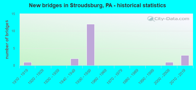
- New bridges - historical statistics
- 11910-1919
- 21940-1949
- 121950-1959
- 12000-2009
- 32010-2019

- Reconstructed bridges - Historical Statistics
- 11930-1939
- 01940-1949
- 01950-1959
- 01960-1969
- 21970-1979
- 41980-1989
- 21990-1999
- 02000-2009
- 12010-2019


- Bridge Condition - Deck
- 9.1%Excellent
- 9.1%Very good
- 18.2%Good
- 36.4%Satisfactory
- 18.2%Fair
- 9.1%Poor

- Bridge Condition - Superstructure
- 18.2%Good
- 45.5%Satisfactory
- 27.3%Fair
- 9.1%Poor

- Bridge Condition - Substructure
- 27.3%Good
- 27.3%Satisfactory
- 36.4%Fair
- 9.1%Serious

- Bridge Condition - Channel
- 10.0%Good
- 20.0%Satisfactory
- 40.0%Fair
- 30.0%Poor

- Bridge Condition - Culverts
- 50.0%Satisfactory
- 50.0%Fair
Find on map >> Show street view
Structure Number: 26728, Location: EXIT#305(48);US209 BUS. (Lat: 40.982381, Lng: -75.213764), Route carried "on" structure: Interstate 80, Year Built: 1959, Year Reconstructed: 1986, Status: Open, Structure Length: 6.74m (22.11ft), Average Daily Traffic: 59,326 (year 2022), Truck Traffic: 17%, Average Future Daily Traffic: 72,870 (year 2032), Design Load: HS 20+Mod, Features Intersected: SR 2012(LR164)
Minimum Vertical Clearance: 30+ m (98+ ft), Kilometerpoint: 36.460, Lanes on structure: 4, Lanes under structure: 2, Base Highway Network: Yes, Owner: State Highway Agency, Approaching Roadway Width: 25.6m (84.0ft), Skew: 35 degrees, Material/Design: Steel, Design/Construction: Stringer/Multi-beam, Number Of Spans In Main Unit: 1, Number Of Approach Spans: 2, Length of Maximum Span: 28.7m (94.2ft), Curb or Sidewalk Widths: Left: 0.2m (0.7ft), Right: 0.2m (0.7ft), Curb-To-Curb Width: 25.3m (83.0ft), Out-to-Out Width: 27.3m (89.6ft)
Condition: Deck: Satisfactory, Superstructure: Fair, Substructure: Fair, Operating Rating: 60.8 metric tons, Method Used To Determine Operating Rating: Load Factor (LF), Inventory Rating: 36.3 metric tons, Method Used To Determine Inventory Rating: Load Factor (LF), Structural Evaluation: Somewhat better than minimum adequacy, Deck Geometry: Superior to present desirable criteria, Underclear: High priority of corrective action, Approach Roadway Alignment: Equal to present desirable criteria, Length Of Structure Improvement: 7.70m (25.26ft), Designated Inspection Frequency: Every 24 months, Inspection Date: April 2021, Bridge Improvement Cost: $22,000, Roadway Improvement Cost: $65,000, Total Project Cost: $298,000, Deck Structure Type: Concrete Cast-file-Place, Wearing Surface/Protective System: Wearing Surface: Monolithic Concrete, Deck Protection: Epoxy Coated Reinforcing
Find on map >> Show street view
Structure Number: 2673, Location: BORO OF STROUDSBURG (Lat: 40.981606, Lng: -75.212183), Route carried "on" structure: Interstate 80, Year Built: 1959, Status: Open, Structure Length: 0.64m (2.10ft), Average Daily Traffic: 59,326 (year 2022), Truck Traffic: 17%, Average Future Daily Traffic: 72,870 (year 2032), Design Load: HS 20, Features Intersected: LITTLE POCONO CREEK
Minimum Vertical Clearance: 30+ m (98+ ft), Kilometerpoint: 36.460, Lanes on structure: 4, Base Highway Network: Yes, Owner: State Highway Agency, Approaching Roadway Width: 25.6m (84.0ft), Skew: 32 degrees, Material/Design: Concrete, Design/Construction: Culvert, Number Of Spans In Main Unit: 1, Length of Maximum Span: 6.4m (21.0ft)
Condition: Channel: Fair, Culverts: Satisfactory, Inventory Rating: 85.3 metric tons, Method Used To Determine Inventory Rating: Load Factor (LF), Structural Evaluation: Equal to present minimum criteria, Waterway Adequacy: Superior to present desirable criteria, Approach Roadway Alignment: Equal to present desirable criteria, Length Of Structure Improvement: 1.20m (3.94ft), Designated Inspection Frequency: Every 48 months, Inspection Date: October 2021
Find on map >> Show street view
Structure Number: 26731, Location: EXIT#306(49);DREHER AVE. (Lat: 40.980311, Lng: -75.206636), Route carried "on" structure: Interstate 80, Year Built: 1959, Year Reconstructed: 1986, Status: Open, Structure Length: 1.71m (5.61ft), Average Daily Traffic: 67,426 (year 2022), Truck Traffic: 14%, Average Future Daily Traffic: 82,966 (year 2032), Design Load: HS 20+Mod, Features Intersected: SR 2004(LR 165)
Minimum Vertical Clearance: 30+ m (98+ ft), Kilometerpoint: 37.251, Lanes on structure: 4, Lanes under structure: 2, Base Highway Network: Yes, Owner: State Highway Agency, Approaching Roadway Width: 12.8m (42.0ft), Skew: 33 degrees, Material/Design: Prestressed concrete, Design/Construction: Stringer/Multi-beam, Number Of Spans In Main Unit: 1, Length of Maximum Span: 16.5m (54.1ft), Curb-To-Curb Width: 25.9m (85.0ft), Out-to-Out Width: 27.9m (91.5ft)
Condition: Deck: Satisfactory, Superstructure: Satisfactory, Substructure: Fair, Operating Rating: 81.6 metric tons, Method Used To Determine Operating Rating: Load Factor (LF), Inventory Rating: 34.5 metric tons, Method Used To Determine Inventory Rating: Load Factor (LF), Structural Evaluation: Somewhat better than minimum adequacy, Deck Geometry: Superior to present desirable criteria, Underclear: Meets minimum limits, Approach Roadway Alignment: Equal to present desirable criteria, Length Of Structure Improvement: 2.40m (7.87ft), Designated Inspection Frequency: Every 24 months, Inspection Date: December 2020, Deck Structure Type: Concrete Cast-file-Place, Wearing Surface/Protective System: Wearing Surface: Monolithic Concrete, Deck Protection: Epoxy Coated Reinforcing
Find on map >> Show street view
Structure Number: 26733, Location: NEAR EXIT #306(49) (Lat: 40.979014, Lng: -75.200644), Route carried "on" structure: Interstate 80, Year Built: 1959, Year Reconstructed: 1986, Status: Open, Structure Length: 9.85m (32.32ft), Average Daily Traffic: 72,047 (year 2022), Truck Traffic: 19%, Average Future Daily Traffic: 83,594 (year 2032), Design Load: HS 20+Mod, Features Intersected: MCMICHAEL CREEK
Minimum Vertical Clearance: 30+ m (98+ ft), Kilometerpoint: 37.251, Lanes on structure: 4, Base Highway Network: Yes, Owner: State Highway Agency, Approaching Roadway Width: 20.7m (67.9ft), Skew: 33 degrees, Material/Design: Prestressed concrete, Design/Construction: Stringer/Multi-beam, Number Of Spans In Main Unit: 4, Length of Maximum Span: 27.4m (89.9ft), Curb-To-Curb Width: 18.0m (59.1ft), Out-to-Out Width: 20.0m (65.6ft)
Condition: Deck: Satisfactory, Superstructure: Satisfactory, Substructure: Satisfactory, Channel: Fair, Operating Rating: 80.7 metric tons, Method Used To Determine Operating Rating: Load Factor (LF), Inventory Rating: 26.3 metric tons, Method Used To Determine Inventory Rating: Load Factor (LF), Structural Evaluation: Equal to present minimum criteria, Deck Geometry: Meets minimum limits, Waterway Adequacy: Superior to present desirable criteria, Approach Roadway Alignment: Equal to present desirable criteria, Length Of Structure Improvement: 10.90m (35.76ft), Designated Inspection Frequency: Every 24 months, Inspection Date: March 2021, Bridge Improvement Cost: $51,000, Roadway Improvement Cost: $151,000, Total Project Cost: $692,000, Deck Structure Type: Concrete Cast-file-Place, Wearing Surface/Protective System: Wearing Surface: Monolithic Concrete, Deck Protection: Epoxy Coated Reinforcing
Find on map >> Show street view
Structure Number: 26762, Location: 2.2 MI.S.OF STROUDSBURG (Lat: 40.954072, Lng: -75.196506), Route carried "on" structure: State highway 191, Year Built: 1916, Year Reconstructed: 1942, Status: Open, Structure Length: 0.85m (2.79ft), Average Daily Traffic: 3,311 (year 2021), Truck Traffic: 4%, Average Future Daily Traffic: 5,509 (year 2032), Features Intersected: MOUNTAIN RUN CREEK
Minimum Vertical Clearance: 30+ m (98+ ft), Kilometerpoint: 2.287, Lanes on structure: 2, Base Highway Network: Yes, Owner: State Highway Agency, Approaching Roadway Width: 11.0m (36.1ft), Skew: 4 degrees, Material/Design: Masonry, Design/Construction: Culvert, Number Of Spans In Main Unit: 1, Length of Maximum Span: 8.5m (27.9ft)
Condition: Channel: Poor, Culverts: Fair, Operating Rating: 49.0 metric tons, Method Used To Determine Operating Rating: Field evaluation and documented engineering judgment, Inventory Rating: 32.7 metric tons, Method Used To Determine Inventory Rating: Field evaluation and documented engineering judgment, Structural Evaluation: Somewhat better than minimum adequacy, Waterway Adequacy: Superior to present desirable criteria, Approach Roadway Alignment: Equal to present desirable criteria, Length Of Structure Improvement: 1.50m (4.92ft), Designated Inspection Frequency: Every 24 months, Inspection Date: March 2021
Find on map >> Show street view
Structure Number: 26763, Location: 1.8MI.S.OF STROUDSBURG (Lat: 40.962339, Lng: -75.196100), Route carried "on" structure: State highway 191, Year Built: 1958, Year Reconstructed: 2016, Status: Open, Structure Length: 2.29m (7.51ft), Average Daily Traffic: 3,311 (year 2021), Truck Traffic: 4%, Average Future Daily Traffic: 5,509 (year 2032), Design Load: HL 93, Features Intersected: CHERRY CREEK
Minimum Vertical Clearance: 30+ m (98+ ft), Kilometerpoint: 3.436, Lanes on structure: 2, Base Highway Network: Yes, Owner: State Highway Agency, Approaching Roadway Width: 10.4m (34.1ft), Material/Design: Prestressed concrete, Design/Construction: Box Beam or Girders - Multiple, Number Of Spans In Main Unit: 1, Length of Maximum Span: 22.3m (73.2ft), Curb-To-Curb Width: 8.7m (28.5ft), Out-to-Out Width: 9.2m (30.2ft)
Condition: Deck: Very good, Superstructure: Satisfactory, Substructure: Good, Channel: Fair, Operating Rating: 55.7 metric tons, Method Used To Determine Operating Rating: Assigned ratings based on Load and Resistance Factor Design (LRFD) reported by rating factor (RF) using HL93 loadings, Inventory Rating: 37.9 metric tons, Method Used To Determine Inventory Rating: Assigned ratings based on Load and Resistance Factor Design (LRFD) reported by rating factor (RF) using HL93 loadings, Structural Evaluation: Equal to present minimum criteria, Deck Geometry: Meets minimum limits, Waterway Adequacy: Equal to present minimum criteria, Approach Roadway Alignment: Equal to present desirable criteria, Length Of Structure Improvement: 3.00m (9.84ft), Designated Inspection Frequency: Every 48 months, Inspection Date: December 2018, Deck Structure Type: Concrete Cast-file-Place, Wearing Surface/Protective System: Wearing Surface: Monolithic Concrete, Deck Protection: Epoxy Coated Reinforcing
Find on map >> Show street view
Structure Number: 26764, Location: BROAD ST.OVER I-80 (Lat: 40.984161, Lng: -75.190108), Route carried "on" structure: State highway 191, Year Built: 1959, Year Reconstructed: 1996, Status: Open, Structure Length: 3.17m (10.40ft), Average Daily Traffic: 4,907 (year 2021), Truck Traffic: 4%, Average Future Daily Traffic: 7,837 (year 2032), Design Load: HS 20, Features Intersected: I-80
Minimum Vertical Clearance: 30+ m (98+ ft), Kilometerpoint: 6.088, Lanes on structure: 2, Lanes under structure: 8, Base Highway Network: Yes, Owner: State Highway Agency, Approaching Roadway Width: 9.1m (29.9ft), Skew: 2 degrees, Material/Design: Steel, Design/Construction: Stringer/Multi-beam, Number Of Spans In Main Unit: 1, Length of Maximum Span: 29.9m (98.1ft), Curb or Sidewalk Widths: Left: 1.5m (4.9ft), Right: 1.5m (4.9ft), Curb-To-Curb Width: 9.1m (29.9ft), Out-to-Out Width: 13.0m (42.7ft)
Condition: Deck: Satisfactory, Superstructure: Satisfactory, Substructure: Satisfactory, Operating Rating: 89.8 metric tons, Method Used To Determine Operating Rating: Load Factor (LF), Inventory Rating: 54.4 metric tons, Method Used To Determine Inventory Rating: Load Factor (LF), Structural Evaluation: Equal to present minimum criteria, Deck Geometry: Meets minimum limits, Underclear: High priority of corrective action, Approach Roadway Alignment: Equal to present desirable criteria, Length Of Structure Improvement: 4.00m (13.12ft), Designated Inspection Frequency: Every 24 months, Inspection Date: September 2020, Bridge Improvement Cost: $12,000, Roadway Improvement Cost: $36,000, Total Project Cost: $163,000, Deck Structure Type: Concrete Cast-file-Place, Wearing Surface/Protective System: Wearing Surface: Latex Concrete
Find on map >> Show street view
Structure Number: 26765, Location: BROAD STREET,STROUDSBURG (Lat: 40.985553, Lng: -75.190442), Route carried "on" structure: State highway 191, Year Built: 1955, Year Reconstructed: 1996, Status: Open, Structure Length: 5.55m (18.21ft), Average Daily Traffic: 11,682 (year 2022), Truck Traffic: 4%, Average Future Daily Traffic: 17,254 (year 2032), Design Load: HS 20, Features Intersected: MCMICHAEL CREEK
Minimum Vertical Clearance: 30+ m (98+ ft), Kilometerpoint: 6.088, Lanes on structure: 3, Base Highway Network: Yes, Owner: State Highway Agency, Approaching Roadway Width: 9.1m (29.9ft), Skew: 2 degrees, Material/Design: Steel continuous, Design/Construction: Stringer/Multi-beam, Number Of Spans In Main Unit: 2, Length of Maximum Span: 37.5m (123.0ft), Curb or Sidewalk Widths: Left: 1.5m (4.9ft), Right: 1.5m (4.9ft), Curb-To-Curb Width: 9.1m (29.9ft), Out-to-Out Width: 12.8m (42.0ft)
Condition: Deck: Poor, Superstructure: Satisfactory, Substructure: Satisfactory, Channel: Good, Operating Rating: 89.8 metric tons, Method Used To Determine Operating Rating: Load Factor (LF), Inventory Rating: 61.7 metric tons, Method Used To Determine Inventory Rating: Load Factor (LF), Structural Evaluation: Equal to present minimum criteria, Deck Geometry: High priority of replacement, Waterway Adequacy: Equal to present minimum criteria, Approach Roadway Alignment: Equal to present desirable criteria, Length Of Structure Improvement: 6.50m (21.33ft), Designated Inspection Frequency: Every 24 months, Inspection Date: October 2020, Bridge Improvement Cost: $20,000, Roadway Improvement Cost: $58,000, Total Project Cost: $265,000, Deck Structure Type: Concrete Cast-file-Place, Wearing Surface/Protective System: Wearing Surface: Latex Concrete
Find on map >> Show street view
Structure Number: 26977, Location: J.SUMMERFIELD STAPLES BR. (Lat: 40.983619, Lng: -75.200467), Route carried "on" structure: Business US 209B, Year Built: 1957, Year Reconstructed: 1980, Status: Open, Structure Length: 4.60m (15.09ft), Average Daily Traffic: 10,268 (year 2021), Truck Traffic: 3%, Average Future Daily Traffic: 22,923 (year 2032), Design Load: HL 93, Features Intersected: POCONO CREEK, Facility Carried by Structure: US 209 BUS (LR164)
Minimum Vertical Clearance: 30+ m (98+ ft), Kilometerpoint: 16.565, Lanes on structure: 2, Base Highway Network: Yes, Owner: State Highway Agency, Approaching Roadway Width: 15.2m (49.9ft), Material/Design: Prestressed concrete, Design/Construction: Box Beam or Girders - Multiple, Number Of Spans In Main Unit: 2, Length of Maximum Span: 22.3m (73.2ft), Curb or Sidewalk Widths: Left: 2.7m (8.9ft), Right: 1.8m (5.9ft), Curb-To-Curb Width: 15.2m (49.9ft), Out-to-Out Width: 20.4m (66.9ft)
Condition: Deck: Excellent, Superstructure: Fair, Substructure: Fair, Channel: Fair, Operating Rating: 59.9 metric tons, Method Used To Determine Operating Rating: Assigned ratings based on Load and Resistance Factor Design (LRFD) reported by rating factor (RF) using HL93 loadings, Inventory Rating: 36.3 metric tons, Method Used To Determine Inventory Rating: Assigned ratings based on Load and Resistance Factor Design (LRFD) reported by rating factor (RF) using HL93 loadings, Structural Evaluation: Somewhat better than minimum adequacy, Deck Geometry: Superior to present desirable criteria, Waterway Adequacy: Equal to present desirable criteria, Approach Roadway Alignment: Equal to present desirable criteria, Length Of Structure Improvement: 5.50m (18.04ft), Designated Inspection Frequency: Every 24 months, Inspection Date: April 2020, Deck Structure Type: Other, Wearing Surface/Protective System: Wearing Surface: Monolithic Concrete, Deck Protection: Epoxy Coated Reinforcing
Find on map >> Show street view
Structure Number: 27121, Location: 1 M.N OF CAMP BIG POCONO (Lat: 40.961769, Lng: -75.203072), Route carried "on" structure: City street , Year Built: 1940, Year Reconstructed: 1970, Status: Posted for load, Structure Length: 1.10m (3.61ft), Average Daily Traffic: 38 (year 2005), Truck Traffic: 1%, Average Future Daily Traffic: 50 (year 2035), Design Load: HS 20, Features Intersected: CHERRY CREEK, Facility Carried by Structure: LESSIG LANE T-410
Minimum Vertical Clearance: 30+ m (98+ ft), Kilometerpoint: 0.000, Lanes on structure: 2, Owner: Town or Township Highway Agency, Approaching Roadway Width: 4.0m (13.1ft), Material/Design: Steel, Design/Construction: Stringer/Multi-beam, Number Of Spans In Main Unit: 1, Length of Maximum Span: 6.7m (22.0ft), Curb-To-Curb Width: 3.7m (12.1ft), Out-to-Out Width: 5.2m (17.1ft)
Condition: Deck: Fair, Superstructure: Poor, Substructure: Fair, Channel: Poor, Operating Rating: 68.0 metric tons, Method Used To Determine Operating Rating: Load Factor (LF), Inventory Rating: 40.8 metric tons, Method Used To Determine Inventory Rating: Load Factor (LF), Structural Evaluation: Meets minimum limits, Deck Geometry: High priority of replacement, Waterway Adequacy: Better than present minimum criteria, Approach Roadway Alignment: Equal to present desirable criteria, Length Of Structure Improvement: 1.10m (3.61ft), Designated Inspection Frequency: Every 24 months, Other Special Inspection Frequency: Every 12 months, Inspection Date: June 2020, Other Special Inspection Date: June 2021, Bridge Improvement Cost: $8,000, Roadway Improvement Cost: $52,000, Total Project Cost: $107,000, Deck Structure Type: Concrete Cast-file-Place, Wearing Surface/Protective System: Wearing Surface: Monolithic Concrete
Find on map >> Show street view
Structure Number: 27122, Location: 750'FT.SOUTH OF LR 45010 (Lat: 40.971842, Lng: -75.172100), Route carried "on" structure: City street , Year Built: 1940, Year Reconstructed: 1970, Status: Open, Structure Length: 0.94m (3.08ft), Average Daily Traffic: 27 (year 2005), Average Future Daily Traffic: 30 (year 2035), Design Load: HS 20, Features Intersected: CHERRY CREEK, Facility Carried by Structure: CROASDALE RD T-420
Minimum Vertical Clearance: 30+ m (98+ ft), Kilometerpoint: 0.000, Lanes on structure: 1, Owner: Town or Township Highway Agency, Approaching Roadway Width: 4.0m (13.1ft), Material/Design: Steel, Design/Construction: Stringer/Multi-beam, Number Of Spans In Main Unit: 1, Length of Maximum Span: 8.5m (27.9ft), Curb-To-Curb Width: 4.1m (13.5ft), Out-to-Out Width: 5.2m (17.1ft)
Condition: Deck: Fair, Superstructure: Fair, Substructure: Serious, Channel: Poor, Operating Rating: 82.6 metric tons, Method Used To Determine Operating Rating: Load Factor (LF), Inventory Rating: 49.0 metric tons, Method Used To Determine Inventory Rating: Load Factor (LF), Structural Evaluation: High priority of corrective action, Deck Geometry: Somewhat better than minimum adequacy, Waterway Adequacy: Better than present minimum criteria, Approach Roadway Alignment: Meets minimum limits, Length Of Structure Improvement: 0.90m (2.95ft), Designated Inspection Frequency: Every 24 months, Other Special Inspection Frequency: Every 12 months, Inspection Date: June 2020, Other Special Inspection Date: June 2021, Bridge Improvement Cost: $10,000, Roadway Improvement Cost: $72,000, Total Project Cost: $129,000, Deck Structure Type: Concrete Cast-file-Place, Wearing Surface/Protective System: Wearing Surface: Monolithic Concrete
Find on map >> Show street view
Structure Number: 40958, Location: SOUTH OF STROUDSBURG (Lat: 40.958639, Lng: -75.198519), Route carried "on" structure: City street , Year Built: 2000, Status: Open, Structure Length: 0.73m (2.40ft), Average Daily Traffic: 280 (year 2000), Average Future Daily Traffic: 478 (year 2030), Design Load: HS 20, Features Intersected: TRIB TO CHERRY CREEK, Facility Carried by Structure: MIDDLE ROAD
Minimum Vertical Clearance: 30+ m (98+ ft), Kilometerpoint: 0.000, Lanes on structure: 2, Owner: Town or Township Highway Agency, Approaching Roadway Width: 7.3m (24.0ft), Skew: 1 degrees, Material/Design: Prestressed concrete, Design/Construction: Slab, Number Of Spans In Main Unit: 1, Length of Maximum Span: 6.7m (22.0ft), Curb-To-Curb Width: 7.4m (24.3ft), Out-to-Out Width: 8.6m (28.2ft)
Condition: Deck: Good, Superstructure: Good, Substructure: Good, Channel: Satisfactory, Operating Rating: 68.0 metric tons, Method Used To Determine Operating Rating: Load Factor (LF), Inventory Rating: 34.5 metric tons, Method Used To Determine Inventory Rating: Load Factor (LF), Structural Evaluation: Better than present minimum criteria, Deck Geometry: Somewhat better than minimum adequacy, Waterway Adequacy: Equal to present minimum criteria, Approach Roadway Alignment: Equal to present desirable criteria, Length Of Structure Improvement: 1.40m (4.59ft), Designated Inspection Frequency: Every 24 months, Inspection Date: November 2020, Wearing Surface/Protective System: Wearing Surface: Bituminous, Membrane: Preformed Fabric
Find on map >> Show street view
Structure Number: 47729, Location: SOUTH 7TH.ST.STROUDSBURG (Lat: 40.982919, Lng: -75.192019), Route carried "on" structure: State highway 611, Year Built: 2012, Status: Open, Structure Length: 16.86m (55.31ft), Average Daily Traffic: 5,540 (year 2022), Truck Traffic: 3%, Average Future Daily Traffic: 10,436 (year 2039), Design Load: HL 93, Features Intersected: I-80 & MCMICHAEL CREEK
Minimum Vertical Clearance: 30+ m (98+ ft), Kilometerpoint: 7.765, Lanes on structure: 2, Lanes under structure: 4, Owner: State Highway Agency, Approaching Roadway Width: 10.4m (34.1ft), Skew: 1 degrees, Material/Design: Prestressed concrete continuous, Design/Construction: Tee Beam, Number Of Spans In Main Unit: 4, Length of Maximum Span: 47.2m (154.9ft), Curb or Sidewalk Widths: Left: 1.6m (5.2ft), Right: 1.6m (5.2ft), Curb-To-Curb Width: 10.4m (34.1ft), Out-to-Out Width: 14.2m (46.6ft)
Condition: Deck: Good, Superstructure: Good, Substructure: Good, Channel: Satisfactory, Operating Rating: 61.6 metric tons, Method Used To Determine Operating Rating: Assigned ratings based on Load and Resistance Factor Design (LRFD) reported by rating factor (RF) using HL93 loadings, Inventory Rating: 37.9 metric tons, Method Used To Determine Inventory Rating: Assigned ratings based on Load and Resistance Factor Design (LRFD) reported by rating factor (RF) using HL93 loadings, Structural Evaluation: Better than present minimum criteria, Deck Geometry: Meets minimum limits, Underclear: High priority of corrective action, Waterway Adequacy: Superior to present desirable criteria, Approach Roadway Alignment: Better than present minimum criteria, Designated Inspection Frequency: Every 48 months, Inspection Date: December 2020, Deck Structure Type: Concrete Cast-file-Place, Wearing Surface/Protective System: Wearing Surface: Epoxy Overlay, Deck Protection: Epoxy Coated Reinforcing
Find on map >> Show street view
Structure Number: 26728, Location: EXIT#305(48);US209 BUS. (Lat: 40.982381, Lng: -75.213764), Route carried "under" structure: Business US 209B, Year Built: 1959, Structure Length: 0. m, Average Daily Traffic: 10,521 (year 2022), Truck Traffic: 5%, Features Intersected: SR 2012(LR164), Facility Carried by Structure: I-80(LR794)
Minimum Vertical Clearance: 4.57m (14.99ft), Kilometerpoint: 15.397, Lanes on structure: 4, Lanes under structure: 2, Material/Design: Steel, Design/Construction: Stringer/Multi-beam, Length of Maximum Span: 28.7m (94.2ft)
Find on map >> Show street view
Structure Number: 26731, Location: EXIT#306(49);DREHER AVE. (Lat: 40.980311, Lng: -75.206636), Route carried "under" structure: State highway , Year Built: 1959, Structure Length: 0. m, Average Daily Traffic: 3,666 (year 2022), Truck Traffic: 4%, Features Intersected: SR 2004(LR 165), Facility Carried by Structure: I-80
Minimum Vertical Clearance: 4.48m (14.70ft), Kilometerpoint: 14.336, Lanes on structure: 4, Lanes under structure: 2, Material/Design: Prestressed concrete, Design/Construction: Stringer/Multi-beam, Length of Maximum Span: 16.5m (54.1ft)
Find on map >> Show street view
Structure Number: 26764, Location: BROAD ST.OVER I-80 (Lat: 40.984161, Lng: -75.190108), Route carried "under" structure: Interstate 80, Year Built: 1959, Structure Length: 0. m, Average Daily Traffic: 36,373 (year 2022), Truck Traffic: 19%, Features Intersected: I-80, Facility Carried by Structure: PA 191
Minimum Vertical Clearance: 5.09m (16.70ft), Kilometerpoint: 39.062, Lanes on structure: 2, Lanes under structure: 4, Material/Design: Steel, Design/Construction: Stringer/Multi-beam, Length of Maximum Span: 29.9m (98.1ft)
Find on map >> Show street view
Structure Number: 26764, Location: BROAD ST.OVER I-80 (Lat: 40.984161, Lng: -75.190108), Route carried "under" structure: Interstate 80, Year Built: 1959, Structure Length: 0. m, Average Daily Traffic: 35,674 (year 2022), Truck Traffic: 19%, Features Intersected: I-80, Facility Carried by Structure: PA 191
Minimum Vertical Clearance: 5.91m (19.39ft), Kilometerpoint: 38.859, Lanes on structure: 2, Lanes under structure: 4, Material/Design: Steel, Design/Construction: Stringer/Multi-beam, Length of Maximum Span: 29.9m (98.1ft)
Find on map >> Show street view
Structure Number: 47729, Location: SOUTH 7TH.ST.STROUDSBURG (Lat: 40.982919, Lng: -75.192019), Route carried "under" structure: Interstate 80, Year Built: 2012, Structure Length: 0. m, Average Daily Traffic: 36,373 (year 2022), Truck Traffic: 19%, Features Intersected: I-80 & MCMICHAEL CREEK, Facility Carried by Structure: PA 611 (LR 498)
Minimum Vertical Clearance: 6.43m (21.10ft), Kilometerpoint: 38.275, Lanes on structure: 2, Lanes under structure: 2, Material/Design: Prestressed concrete continuous, Design/Construction: Tee Beam, Length of Maximum Span: 47.2m (154.9ft)
Find on map >> Show street view
Structure Number: 47729, Location: SOUTH 7TH.ST.STROUDSBURG (Lat: 40.982919, Lng: -75.192019), Route carried "under" structure: Interstate 80, Year Built: 2012, Structure Length: 0. m, Average Daily Traffic: 35,674 (year 2022), Truck Traffic: 19%, Features Intersected: I-80 & MCMICHAEL CREEK, Facility Carried by Structure: PA 611 (LR 498)
Minimum Vertical Clearance: 6.55m (21.49ft), Kilometerpoint: 38.051, Lanes on structure: 2, Lanes under structure: 2, Material/Design: Prestressed concrete continuous, Design/Construction: Tee Beam, Length of Maximum Span: 47.2m (154.9ft)