Bridge Statistics for Stratton, Colorado (CO)
Condition, Traffic, Stress, Structural Evaluation, Project Costs
- National Bridge Inventory (NBI) Statistics
- 10Number of bridges
- 138ft / 42.0mTotal length
- 28,138Total average daily traffic
- 7,210Total average daily truck traffic
- National Bridge Inventory (NBI) Registered Bridges for Stratton
- No street view available for this location
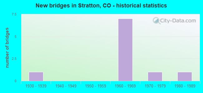
- New bridges - historical statistics
- 11930-1939
- 71960-1969
- 11970-1979
- 11980-1989


- Bridge Condition - Deck
- 14.3%Good
- 85.7%Satisfactory

- Bridge Condition - Superstructure
- 57.1%Satisfactory
- 42.9%Fair

- Bridge Condition - Substructure
- 28.6%Good
- 57.1%Satisfactory
- 14.3%Fair

- Bridge Condition - Channel
- 25.0%Very good
- 25.0%Good
- 50.0%Satisfactory
Find on map >> Show street view
Structure Number: G-26-D, Location: 2 MI W OF STRATTON (Lat: 39.301111, Lng: -102.642331), Route carried "on" structure: US 24B, Year Built: 1931, Status: Open, Structure Length: 5.55m (18.21ft), Average Daily Traffic: 350 (year 2020), Truck Traffic: 13%, Average Future Daily Traffic: 406 (year 2040), Design Load: H 15, Features Intersected: SPRING CREEK, Facility Carried by Structure: US 24 ML
Minimum Vertical Clearance: 30+ m (98+ ft), Kilometerpoint: 25.347, Lanes on structure: 2, Owner: State Highway Agency, Approaching Roadway Width: 6.7m (22.0ft), Material/Design: Steel, Design/Construction: Stringer/Multi-beam, Number Of Spans In Main Unit: 5, Length of Maximum Span: 17.9m (58.7ft), Curb-To-Curb Width: 6.1m (20.0ft), Out-to-Out Width: 7.0m (23.0ft)
Condition: Deck: Satisfactory, Superstructure: Fair, Substructure: Satisfactory, Channel: Satisfactory, Operating Rating: 31.6 metric tons, Method Used To Determine Operating Rating: Load Factor (LF), Inventory Rating: 18.9 metric tons, Method Used To Determine Inventory Rating: Load Factor (LF), Structural Evaluation: Somewhat better than minimum adequacy, Deck Geometry: Meets minimum limits, Waterway Adequacy: Equal to present desirable criteria, Approach Roadway Alignment: Equal to present desirable criteria, Designated Inspection Frequency: Every 24 months, Inspection Date: March 2021, Deck Structure Type: Concrete Cast-file-Place, Wearing Surface/Protective System: Wearing Surface: Bituminous
Find on map >> Show street view
Structure Number: G-26-O, Location: 0.5 MILE W OF STRATTON (Lat: 39.294125, Lng: -102.614053), Route carried "on" structure: County highway , Year Built: 1965, Status: Open, Structure Length: 7.53m (24.70ft), Average Daily Traffic: 419 (year 2014), Average Future Daily Traffic: 616 (year 2034), Design Load: HS 25 or greater, Features Intersected: I 70 ML, Facility Carried by Structure: COUNTY ROAD 30
Minimum Vertical Clearance: 30+ m (98+ ft), Kilometerpoint: 26.449, Lanes on structure: 2, Lanes under structure: 4, Owner: State Highway Agency, Approaching Roadway Width: 7.3m (24.0ft), Material/Design: Concrete continuous, Design/Construction: Tee Beam, Number Of Spans In Main Unit: 5, Length of Maximum Span: 17.4m (57.1ft), Curb or Sidewalk Widths: Left: 0.6m (2.0ft), Right: 0.6m (2.0ft), Curb-To-Curb Width: 7.3m (24.0ft), Out-to-Out Width: 8.5m (27.9ft)
Condition: Deck: Satisfactory, Superstructure: Satisfactory, Substructure: Satisfactory, Operating Rating: 37.2 metric tons, Method Used To Determine Operating Rating: Load Factor (LF), Inventory Rating: 21.8 metric tons, Method Used To Determine Inventory Rating: Load Factor (LF), Structural Evaluation: Equal to present minimum criteria, Deck Geometry: Meets minimum limits, Underclear: Equal to present minimum criteria, Approach Roadway Alignment: Equal to present desirable criteria, Designated Inspection Frequency: Every 24 months, Inspection Date: July 2021, Deck Structure Type: Concrete Cast-file-Place, Wearing Surface/Protective System: Wearing Surface: Monolithic Concrete
Find on map >> Show street view
Structure Number: G-26-P, Location: Stratton Exit (Lat: 39.294150, Lng: -102.604947), Route carried "on" structure: State highway 57A, Year Built: 1965, Status: Open, Structure Length: 7.53m (24.70ft), Average Daily Traffic: 1,800 (year 2020), Truck Traffic: 11%, Average Future Daily Traffic: 1,818 (year 2040), Design Load: H 20, Features Intersected: I 70 ML, Facility Carried by Structure: SH 57 ML
Minimum Vertical Clearance: 30+ m (98+ ft), Kilometerpoint: 0.032, Lanes on structure: 2, Lanes under structure: 4, Owner: State Highway Agency, Approaching Roadway Width: 8.5m (27.9ft), Material/Design: Concrete continuous, Design/Construction: Tee Beam, Number Of Spans In Main Unit: 5, Length of Maximum Span: 17.4m (57.1ft), Curb or Sidewalk Widths: Left: 0.6m (2.0ft), Right: 0.6m (2.0ft), Curb-To-Curb Width: 8.5m (27.9ft), Out-to-Out Width: 9.8m (32.2ft)
Condition: Deck: Satisfactory, Superstructure: Satisfactory, Substructure: Good, Operating Rating: 47.4 metric tons, Method Used To Determine Operating Rating: Load Factor (LF), Inventory Rating: 28.4 metric tons, Method Used To Determine Inventory Rating: Load Factor (LF), Structural Evaluation: Equal to present minimum criteria, Deck Geometry: Somewhat better than minimum adequacy, Underclear: Equal to present minimum criteria, Approach Roadway Alignment: Equal to present desirable criteria, Designated Inspection Frequency: Every 24 months, Inspection Date: July 2021, Deck Structure Type: Concrete Cast-file-Place, Wearing Surface/Protective System: Wearing Surface: Integral Concrete
Find on map >> Show street view
Structure Number: G-26-R, Location: 3.5 MI. E OF JCT S.H. 57 (Lat: 39.294244, Lng: -102.540258), Route carried "on" structure: County highway , Year Built: 1965, Status: Open, Structure Length: 7.53m (24.70ft), Average Daily Traffic: 52 (year 2014), Truck Traffic: 2%, Average Future Daily Traffic: 77 (year 2034), Design Load: HS 25 or greater, Features Intersected: I 70 ML, Facility Carried by Structure: COUNTY ROAD 34
Minimum Vertical Clearance: 30+ m (98+ ft), Kilometerpoint: 7.293, Lanes on structure: 2, Lanes under structure: 4, Owner: State Highway Agency, Approaching Roadway Width: 7.3m (24.0ft), Material/Design: Concrete continuous, Design/Construction: Tee Beam, Number Of Spans In Main Unit: 5, Length of Maximum Span: 17.4m (57.1ft), Curb or Sidewalk Widths: Left: 0.6m (2.0ft), Right: 0.6m (2.0ft), Curb-To-Curb Width: 7.3m (24.0ft), Out-to-Out Width: 8.5m (27.9ft)
Condition: Deck: Satisfactory, Superstructure: Satisfactory, Substructure: Satisfactory, Operating Rating: 37.2 metric tons, Method Used To Determine Operating Rating: Load Factor (LF), Inventory Rating: 21.8 metric tons, Method Used To Determine Inventory Rating: Load Factor (LF), Structural Evaluation: Equal to present minimum criteria, Deck Geometry: Equal to present minimum criteria, Underclear: Equal to present minimum criteria, Approach Roadway Alignment: Equal to present desirable criteria, Designated Inspection Frequency: Every 24 months, Inspection Date: July 2021, Deck Structure Type: Concrete Cast-file-Place, Wearing Surface/Protective System: Wearing Surface: Monolithic Concrete
Find on map >> Show street view
Structure Number: G-26-S, Location: 2.7 MI. W. OF Stratton (Lat: 39.293469, Lng: -102.654986), Route carried "on" structure: Interstate 70A, Year Built: 1965, Status: Open, Structure Length: 6.34m (20.80ft), Average Daily Traffic: 4,350 (year 2020), Truck Traffic: 28%, Average Future Daily Traffic: 5,090 (year 2040), Design Load: HS 20, Features Intersected: EAST SPRING CREEK, Facility Carried by Structure: I 70 ML WBND
Minimum Vertical Clearance: 30+ m (98+ ft), Kilometerpoint: 671.549, Lanes on structure: 2, Base Highway Network: Yes, Owner: State Highway Agency, Approaching Roadway Width: 11.6m (38.1ft), Skew: 14 degrees, Material/Design: Concrete, Design/Construction: Tee Beam, Number Of Spans In Main Unit: 5, Length of Maximum Span: 13.3m (43.6ft), Curb-To-Curb Width: 11.6m (38.1ft), Out-to-Out Width: 12.3m (40.4ft)
Condition: Deck: Satisfactory, Superstructure: Fair, Substructure: Fair, Channel: Very good, Operating Rating: 61.8 metric tons, Method Used To Determine Operating Rating: Load Factor (LF), Inventory Rating: 37.0 metric tons, Method Used To Determine Inventory Rating: Load Factor (LF), Structural Evaluation: Somewhat better than minimum adequacy, Deck Geometry: Equal to present minimum criteria, Waterway Adequacy: Equal to present desirable criteria, Approach Roadway Alignment: Equal to present desirable criteria, Designated Inspection Frequency: Every 24 months, Inspection Date: July 2021, Deck Structure Type: Concrete Cast-file-Place, Wearing Surface/Protective System: Wearing Surface: Other, Membrane: Other
Find on map >> Show street view
Structure Number: G-26-U, Location: 2.7 MI W OF STRATTON (Lat: 39.293125, Lng: -102.655378), Route carried "on" structure: Interstate 70A, Year Built: 1970, Status: Open, Structure Length: 6.34m (20.80ft), Average Daily Traffic: 4,350 (year 2020), Truck Traffic: 28%, Average Future Daily Traffic: 5,090 (year 2040), Design Load: HS 20+Mod, Features Intersected: EAST SPRING CREEK, Facility Carried by Structure: I 70 ML EBND
Minimum Vertical Clearance: 30+ m (98+ ft), Kilometerpoint: 671.515, Lanes on structure: 2, Base Highway Network: Yes, Owner: State Highway Agency, Approaching Roadway Width: 11.6m (38.1ft), Skew: 14 degrees, Material/Design: Concrete, Design/Construction: Tee Beam, Number Of Spans In Main Unit: 5, Length of Maximum Span: 12.6m (41.3ft), Curb-To-Curb Width: 12.8m (42.0ft), Out-to-Out Width: 13.6m (44.6ft)
Condition: Deck: Satisfactory, Superstructure: Satisfactory, Substructure: Satisfactory, Channel: Good, Operating Rating: 72.6 metric tons, Method Used To Determine Operating Rating: Load Factor (LF), Inventory Rating: 43.5 metric tons, Method Used To Determine Inventory Rating: Load Factor (LF), Structural Evaluation: Equal to present minimum criteria, Deck Geometry: Equal to present desirable criteria, Waterway Adequacy: Equal to present desirable criteria, Approach Roadway Alignment: Equal to present desirable criteria, Designated Inspection Frequency: Every 24 months, Inspection Date: July 2021, Deck Structure Type: Concrete Cast-file-Place, Wearing Surface/Protective System: Wearing Surface: Other, Membrane: Other
Find on map >> Show street view
Structure Number: KITC-29-1.20A01, Location: 0.2 MILES NORTH OF ROAD W (Lat: 39.317556, Lng: -102.632556), Route carried "on" structure: County highway , Year Built: 1984, Status: Open, Structure Length: 1.17m (3.84ft), Average Daily Traffic: 37 (year 2018), Average Future Daily Traffic: 54 (year 2038), Features Intersected: E.BRANCH OF SPRING CREEK, Facility Carried by Structure: COUNTY ROAD 29
Minimum Vertical Clearance: 30+ m (98+ ft), Kilometerpoint: 0.210, Lanes on structure: 2, Owner: County Highway Agency, Approaching Roadway Width: 6.7m (22.0ft), Material/Design: Steel, Design/Construction: Stringer/Multi-beam, Number Of Spans In Main Unit: 1, Length of Maximum Span: 11.2m (36.7ft), Curb-To-Curb Width: 9.1m (29.9ft), Out-to-Out Width: 9.3m (30.5ft)
Condition: Deck: Good, Superstructure: Fair, Substructure: Good, Channel: Satisfactory, Operating Rating: 53.4 metric tons, Method Used To Determine Operating Rating: Load Factor (LF), Inventory Rating: 32.0 metric tons, Method Used To Determine Inventory Rating: Load Factor (LF), Structural Evaluation: Somewhat better than minimum adequacy, Deck Geometry: Better than present minimum criteria, Waterway Adequacy: Equal to present desirable criteria, Approach Roadway Alignment: Equal to present desirable criteria, Designated Inspection Frequency: Every 24 months, Inspection Date: December 2021, Deck Structure Type: Corrugated Steel, Wearing Surface/Protective System: Wearing Surface: Gravel
Find on map >> Show street view
Structure Number: G-26-O, Location: 0.5 MILE W OF STRATTON (Lat: 39.294125, Lng: -102.614053), Route carried "under" structure: Interstate 70A, Year Built: 1965, Structure Length: 0. m, Average Daily Traffic: 380 (year 2014), Truck Traffic: 27%, Features Intersected: I 70 ML, Facility Carried by Structure: COUNTY ROAD 30
Minimum Vertical Clearance: 5.49m (18.01ft), Kilometerpoint: 26.448, Lanes on structure: 2, Lanes under structure: 4, Material/Design: Concrete continuous, Design/Construction: Tee Beam, Length of Maximum Span: 17.4m (57.1ft)
Find on map >> Show street view
Structure Number: G-26-P, Location: Stratton Exit (Lat: 39.294150, Lng: -102.604947), Route carried "under" structure: Interstate 70A, Year Built: 1965, Structure Length: 0. m, Average Daily Traffic: 6,400 (year 2011), Truck Traffic: 27%, Features Intersected: I 70 ML, Facility Carried by Structure: SH 57 ML
Minimum Vertical Clearance: 5.64m (18.50ft), Kilometerpoint: 674.671, Lanes on structure: 2, Lanes under structure: 4, Material/Design: Concrete continuous, Design/Construction: Tee Beam, Length of Maximum Span: 17.4m (57.1ft)
Find on map >> Show street view
Structure Number: G-26-R, Location: 3.5 MI. E OF JCT S.H. 57 (Lat: 39.294244, Lng: -102.540258), Route carried "under" structure: Interstate 70A, Year Built: 1965, Structure Length: 0. m, Average Daily Traffic: 10,000 (year 2018), Truck Traffic: 27%, Features Intersected: I 70 ML, Facility Carried by Structure: COUNTY ROAD 34
Minimum Vertical Clearance: 5.38m (17.65ft), Kilometerpoint: 7.292, Lanes on structure: 2, Lanes under structure: 4, Material/Design: Concrete continuous, Design/Construction: Tee Beam, Length of Maximum Span: 17.4m (57.1ft)