Bridge Statistics for Stoystown, Pennsylvania (PA)
Condition, Traffic, Stress, Structural Evaluation, Project Costs
- National Bridge Inventory (NBI) Statistics
- 16Number of bridges
- 144ft / 44.5mTotal length
- $7,996,000Total costs
- 29,542Total average daily traffic
- 2,113Total average daily truck traffic
- National Bridge Inventory (NBI) Registered Bridges for Stoystown
- No street view available for this location
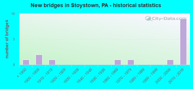
- New bridges - historical statistics
- 1Before 1900
- 21900-1909
- 11910-1919
- 11960-1969
- 11970-1979
- 12000-2009
- 92010-2019

- Reconstructed bridges - Historical Statistics
- 11990-1999
- 12000-2009
- 12010-2019


- Bridge Condition - Deck
- 8.3%Excellent
- 25.0%Very good
- 41.7%Good
- 8.3%Satisfactory
- 8.3%Fair
- 8.3%Poor

- Bridge Condition - Superstructure
- 35.7%Very good
- 21.4%Good
- 14.3%Satisfactory
- 14.3%Fair
- 14.3%Poor

- Bridge Condition - Substructure
- 21.4%Very good
- 42.9%Good
- 21.4%Satisfactory
- 14.3%Fair

- Bridge Condition - Channel
- 45.5%Good
- 27.3%Satisfactory
- 18.2%Fair
- 9.1%Poor
Find on map >> Show street view
Structure Number: 31447, Location: KANTNER (Lat: 40.103147, Lng: -78.932589), Route carried "on" structure: State highway 403, Year Built: 1971, Year Reconstructed: 2011, Status: Open, Structure Length: 7.96m (26.12ft), Average Daily Traffic: 1,419 (year 2020), Truck Traffic: 5%, Average Future Daily Traffic: 1,782 (year 2032), Design Load: HS 20, Features Intersected: STONYCREEK RIVER
Minimum Vertical Clearance: 30+ m (98+ ft), Kilometerpoint: 1.247, Lanes on structure: 2, Owner: State Highway Agency, Approaching Roadway Width: 9.1m (29.9ft), Skew: 4 degrees, Material/Design: Prestressed concrete, Design/Construction: Box Beam or Girders - Single/Spread, Number Of Spans In Main Unit: 4, Length of Maximum Span: 19.2m (63.0ft), Curb or Sidewalk Widths: Left: 0.2m (0.7ft), Right: 0.2m (0.7ft), Curb-To-Curb Width: 13.4m (44.0ft), Out-to-Out Width: 14.6m (47.9ft)
Condition: Deck: Satisfactory, Superstructure: Satisfactory, Substructure: Fair, Channel: Fair, Operating Rating: 64.4 metric tons, Method Used To Determine Operating Rating: Load Factor (LF), Inventory Rating: 28.1 metric tons, Method Used To Determine Inventory Rating: Load Factor (LF), Structural Evaluation: Somewhat better than minimum adequacy, Deck Geometry: Equal to present desirable criteria, Waterway Adequacy: Equal to present minimum criteria, Approach Roadway Alignment: Somewhat better than minimum adequacy, Length Of Structure Improvement: 9.90m (32.48ft), Designated Inspection Frequency: Every 24 months, Inspection Date: July 2021, Bridge Improvement Cost: $261,000, Roadway Improvement Cost: $769,000, Total Project Cost: $3,525,000, Deck Structure Type: Concrete Cast-file-Place, Wearing Surface/Protective System: Wearing Surface: Latex Concrete
Find on map >> Show street view
Structure Number: 3176, Location: 3 MI.NW.OF STOYSTOWN (Lat: 40.140697, Lng: -78.967703), Route carried "on" structure: State highway , Year Built: 1908, Status: Open, Structure Length: 1.01m (3.31ft), Average Daily Traffic: 398 (year 2020), Average Future Daily Traffic: 387 (year 2032), Design Load: H 15, Features Intersected: HIGGINS RUN, Facility Carried by Structure: SR 4021
Minimum Vertical Clearance: 30+ m (98+ ft), Kilometerpoint: 2.892, Lanes on structure: 1, Owner: State Highway Agency, Approaching Roadway Width: 4.9m (16.1ft), Material/Design: Concrete, Design/Construction: Arch - Deck, Number Of Spans In Main Unit: 1, Length of Maximum Span: 9.1m (29.9ft), Curb-To-Curb Width: 4.0m (13.1ft), Out-to-Out Width: 4.9m (16.1ft)
Condition: Superstructure: Fair, Substructure: Good, Channel: Poor, Operating Rating: 74.4 metric tons, Method Used To Determine Operating Rating: Field evaluation and documented engineering judgment, Inventory Rating: 44.5 metric tons, Method Used To Determine Inventory Rating: Field evaluation and documented engineering judgment, Structural Evaluation: Somewhat better than minimum adequacy, Deck Geometry: High priority of replacement, Waterway Adequacy: Equal to present desirable criteria, Approach Roadway Alignment: Equal to present desirable criteria, Length Of Structure Improvement: 1.20m (3.94ft), Designated Inspection Frequency: Every 24 months, Inspection Date: July 2021, Bridge Improvement Cost: $48,000, Roadway Improvement Cost: $264,000, Total Project Cost: $646,000
Find on map >> Show street view
Structure Number: 31883, Location: 1.5 MI.SW.OF STOYSTOWN (Lat: 40.091272, Lng: -78.966653), Route carried "on" structure: City street , Year Built: 1964, Status: Open, Structure Length: 1.77m (5.81ft), Average Daily Traffic: 60 (year 2021), Truck Traffic: 1%, Average Future Daily Traffic: 75 (year 2041), Design Load: H 20, Features Intersected: BEAVER DAM CREEK, Facility Carried by Structure: T611,DUNMYER ROAD
Minimum Vertical Clearance: 30+ m (98+ ft), Kilometerpoint: 0.000, Lanes on structure: 2, Owner: County Highway Agency, Approaching Roadway Width: 5.5m (18.0ft), Skew: 3 degrees, Material/Design: Prestressed concrete, Design/Construction: Box Beam or Girders - Multiple, Number Of Spans In Main Unit: 1, Length of Maximum Span: 17.1m (56.1ft), Curb or Sidewalk Widths: Left: 0.2m (0.7ft), Right: 0.2m (0.7ft), Curb-To-Curb Width: 8.1m (26.6ft), Out-to-Out Width: 8.6m (28.2ft)
Condition: Deck: Poor, Superstructure: Poor, Substructure: Satisfactory, Channel: Good, Operating Rating: 50.8 metric tons, Method Used To Determine Operating Rating: Load Factor (LF), Inventory Rating: 21.8 metric tons, Method Used To Determine Inventory Rating: Load Factor (LF), Structural Evaluation: Meets minimum limits, Deck Geometry: Equal to present minimum criteria, Waterway Adequacy: Equal to present desirable criteria, Approach Roadway Alignment: Equal to present desirable criteria, Length Of Structure Improvement: 2.20m (7.22ft), Designated Inspection Frequency: Every 24 months, Inspection Date: June 2021, Bridge Improvement Cost: $64,000, Roadway Improvement Cost: $264,000, Total Project Cost: $864,000, Deck Structure Type: Other, Wearing Surface/Protective System: Wearing Surface: Bituminous
Find on map >> Show street view
Structure Number: 31884, Location: .5 MI.S.OF STOYSTOWN (Lat: 40.093239, Lng: -78.954125), Route carried "on" structure: City street , Year Built: 1900, Year Reconstructed: 2016, Status: Open, Structure Length: 2.44m (8.01ft), Average Daily Traffic: 150 (year 2020), Truck Traffic: 1%, Average Future Daily Traffic: 188 (year 2040), Design Load: HS 20, Features Intersected: BEAVER DAM CREEK, Facility Carried by Structure: T-625 BRNS.HILL RD
Minimum Vertical Clearance: 30+ m (98+ ft), Kilometerpoint: 0.000, Lanes on structure: 1, Owner: County Highway Agency, Approaching Roadway Width: 5.5m (18.0ft), Material/Design: Prestressed concrete, Design/Construction: Box Beam or Girders - Multiple, Number Of Spans In Main Unit: 1, Length of Maximum Span: 24.1m (79.1ft), Curb or Sidewalk Widths: Left: 0.2m (0.7ft), Right: 0.2m (0.7ft), Curb-To-Curb Width: 4.4m (14.4ft), Out-to-Out Width: 5.2m (17.1ft)
Condition: Deck: Very good, Superstructure: Fair, Substructure: Fair, Channel: Satisfactory, Operating Rating: 75.3 metric tons, Method Used To Determine Operating Rating: Load Factor (LF), Inventory Rating: 21.8 metric tons, Method Used To Determine Inventory Rating: Load Factor (LF), Structural Evaluation: Somewhat better than minimum adequacy, Deck Geometry: High priority of replacement, Waterway Adequacy: Better than present minimum criteria, Approach Roadway Alignment: Equal to present desirable criteria, Length Of Structure Improvement: 3.00m (9.84ft), Designated Inspection Frequency: Every 24 months, Inspection Date: November 2020, Bridge Improvement Cost: $79,000, Roadway Improvement Cost: $264,000, Total Project Cost: $1,061,000, Wearing Surface/Protective System: Wearing Surface: Monolithic Concrete, Deck Protection: Epoxy Coated Reinforcing
Find on map >> Show street view
Structure Number: 31887, Location: 1 MI.SW.OF STOYSTOWN (Lat: 40.090794, Lng: -78.962158), Route carried "on" structure: City street , Year Built: 1910, Status: Open, Structure Length: 1.22m (4.00ft), Average Daily Traffic: 50 (year 2021), Average Future Daily Traffic: 64 (year 2041), Features Intersected: BEAVER DAM CREEK, Facility Carried by Structure: T648, READING MINE
Minimum Vertical Clearance: 30+ m (98+ ft), Kilometerpoint: 0.000, Lanes on structure: 1, Owner: County Highway Agency, Approaching Roadway Width: 3.7m (12.1ft), Material/Design: Masonry, Design/Construction: Arch - Deck, Number Of Spans In Main Unit: 1, Length of Maximum Span: 12.2m (40.0ft), Curb-To-Curb Width: 4.1m (13.5ft), Out-to-Out Width: 5.7m (18.7ft)
Condition: Superstructure: Satisfactory, Substructure: Satisfactory, Channel: Fair, Operating Rating: 49.0 metric tons, Method Used To Determine Operating Rating: Field evaluation and documented engineering judgment, Inventory Rating: 32.7 metric tons, Method Used To Determine Inventory Rating: Field evaluation and documented engineering judgment, Structural Evaluation: Equal to present minimum criteria, Deck Geometry: Somewhat better than minimum adequacy, Waterway Adequacy: Equal to present minimum criteria, Approach Roadway Alignment: Equal to present desirable criteria, Length Of Structure Improvement: 1.50m (4.92ft), Designated Inspection Frequency: Every 24 months, Inspection Date: April 2021, Bridge Improvement Cost: $52,000, Roadway Improvement Cost: $264,000, Total Project Cost: $707,000
Find on map >> Show street view
Structure Number: 31888, Location: .3 MI.SE.OF STOYSTOWN (Lat: 40.100039, Lng: -78.948006), Route carried "on" structure: City street , Year Built: 1887, Year Reconstructed: 2002, Status: Posted for load, Structure Length: 2.90m (9.51ft), Average Daily Traffic: 75 (year 2021), Average Future Daily Traffic: 94 (year 2041), Design Load: H 10, Features Intersected: STONYCREEK RIVER, Facility Carried by Structure: T666, LENHART ROAD
Minimum Vertical Clearance: 4.17m (13.68ft), Kilometerpoint: 0.000, Lanes on structure: 1, Owner: County Highway Agency, Approaching Roadway Width: 4.6m (15.1ft), Material/Design: Steel, Design/Construction: Truss - Thru, Number Of Spans In Main Unit: 1, Length of Maximum Span: 28.3m (92.8ft), Curb or Sidewalk Widths: Left: 0.2m (0.7ft), Right: 0.2m (0.7ft), Curb-To-Curb Width: 3.9m (12.8ft), Out-to-Out Width: 4.3m (14.1ft)
Condition: Deck: Fair, Superstructure: Poor, Substructure: Satisfactory, Channel: Satisfactory, Operating Rating: 4.5 metric tons, Method Used To Determine Operating Rating: Allowable Stress (AS), Inventory Rating: 3.6 metric tons, Method Used To Determine Inventory Rating: Allowable Stress (AS), Structural Evaluation: High priority of replacement, Deck Geometry: High priority of replacement, Waterway Adequacy: Equal to present desirable criteria, Approach Roadway Alignment: High priority of corrective action, Bridge Posting: Required (Relationship of Operating Rating to Maximum Legal Load: > 39.9% below), Length Of Structure Improvement: 3.60m (11.81ft), Designated Inspection Frequency: Every 24 months, Critical Feature Inspection Frequency: Every 12 months, Other Special Inspection Frequency: Every 12 months, Inspection Date: October 2020, Critical Feature Inspection Date: October 2021, Other Special Inspection Date: October 2021, Bridge Improvement Cost: $88,000, Roadway Improvement Cost: $264,000, Total Project Cost: $1,193,000, Deck Structure Type: Wood or Timber, Wearing Surface/Protective System: Wearing Surface: Wood or Timber
Find on map >> Show street view
Structure Number: 45184, Location: 0.5 MILE S. OF STOYSTOWN (Lat: 40.092742, Lng: -78.955992), Route carried "on" structure: State highway 281, Year Built: 2008, Status: Open, Structure Length: 2.87m (9.42ft), Average Daily Traffic: 3,942 (year 2022), Truck Traffic: 5%, Average Future Daily Traffic: 4,653 (year 2032), Design Load: HL 93, Features Intersected: BEAVER DAM CREEK
Minimum Vertical Clearance: 30+ m (98+ ft), Kilometerpoint: 52.307, Lanes on structure: 2, Base Highway Network: Yes, Owner: State Highway Agency, Approaching Roadway Width: 12.8m (42.0ft), Skew: 4 degrees, Material/Design: Prestressed concrete, Design/Construction: Box Beam or Girders - Multiple, Number Of Spans In Main Unit: 1, Length of Maximum Span: 28.0m (91.9ft), Curb or Sidewalk Widths: Left: 0.2m (0.7ft), Right: 0.2m (0.7ft), Curb-To-Curb Width: 12.6m (41.3ft), Out-to-Out Width: 13.6m (44.6ft)
Condition: Deck: Very good, Superstructure: Very good, Substructure: Good, Channel: Satisfactory, Operating Rating: 76.2 metric tons, Method Used To Determine Operating Rating: Load and Resistance Factor (LRFR), Inventory Rating: 37.2 metric tons, Method Used To Determine Inventory Rating: Load and Resistance Factor (LRFR), Structural Evaluation: Better than present minimum criteria, Deck Geometry: Equal to present minimum criteria, Waterway Adequacy: Equal to present desirable criteria, Approach Roadway Alignment: Equal to present desirable criteria, Designated Inspection Frequency: Every 24 months, Inspection Date: May 2021, Deck Structure Type: Concrete Cast-file-Place, Wearing Surface/Protective System: Wearing Surface: Bituminous, Membrane: Preformed Fabric, Deck Protection: Epoxy Coated Reinforcing
Find on map >> Show street view
Structure Number: 46097, Location: KANTNER (Lat: 40.097275, Lng: -78.943419), Route carried "on" structure: US 30, Year Built: 2010, Status: Open, Structure Length: 2.04m (6.69ft), Average Daily Traffic: 3,129 (year 2020), Truck Traffic: 14%, Average Future Daily Traffic: 4,188 (year 2040), Design Load: HL 93, Features Intersected: CSX RAILROAD
Minimum Vertical Clearance: 30+ m (98+ ft), Kilometerpoint: 19.293, Lanes on structure: 3, Base Highway Network: Yes, Owner: State Highway Agency, Approaching Roadway Width: 19.8m (65.0ft), Material/Design: Prestressed concrete, Design/Construction: Box Beam or Girders - Multiple, Number Of Spans In Main Unit: 1, Length of Maximum Span: 19.5m (64.0ft), Curb or Sidewalk Widths: Left: 0.2m (0.7ft), Right: 0.2m (0.7ft), Curb-To-Curb Width: 19.9m (65.3ft), Out-to-Out Width: 20.9m (68.6ft)
Condition: Deck: Good, Superstructure: Very good, Substructure: Good, Operating Rating: 68.0 metric tons, Method Used To Determine Operating Rating: Load and Resistance Factor (LRFR), Inventory Rating: 49.9 metric tons, Method Used To Determine Inventory Rating: Load and Resistance Factor (LRFR), Structural Evaluation: Better than present minimum criteria, Deck Geometry: Superior to present desirable criteria, Underclear: High priority of corrective action, Approach Roadway Alignment: Equal to present desirable criteria, Designated Inspection Frequency: Every 48 months, Inspection Date: December 2019, Deck Structure Type: Concrete Cast-file-Place, Wearing Surface/Protective System: Wearing Surface: Epoxy Overlay, Deck Protection: Epoxy Coated Reinforcing
Find on map >> Show street view
Structure Number: 46098, Location: KANTNER (Lat: 40.097847, Lng: -78.947969), Route carried "on" structure: US 30, Year Built: 2010, Status: Open, Structure Length: 4.88m (16.01ft), Average Daily Traffic: 4,256 (year 2020), Truck Traffic: 8%, Average Future Daily Traffic: 5,596 (year 2032), Design Load: HL 93, Features Intersected: STONYCREEK RIVER
Minimum Vertical Clearance: 30+ m (98+ ft), Kilometerpoint: 19.293, Lanes on structure: 2, Base Highway Network: Yes, Owner: State Highway Agency, Approaching Roadway Width: 11.0m (36.1ft), Material/Design: Prestressed concrete, Design/Construction: Box Beam or Girders - Single/Spread, Number Of Spans In Main Unit: 2, Length of Maximum Span: 27.7m (90.9ft), Curb or Sidewalk Widths: Left: 0.2m (0.7ft), Right: 0.2m (0.7ft), Curb-To-Curb Width: 14.0m (45.9ft), Out-to-Out Width: 15.1m (49.5ft)
Condition: Deck: Good, Superstructure: Good, Substructure: Good, Channel: Good, Operating Rating: 73.5 metric tons, Method Used To Determine Operating Rating: Load and Resistance Factor (LRFR), Inventory Rating: 43.5 metric tons, Method Used To Determine Inventory Rating: Load and Resistance Factor (LRFR), Structural Evaluation: Better than present minimum criteria, Deck Geometry: Superior to present desirable criteria, Waterway Adequacy: Equal to present desirable criteria, Approach Roadway Alignment: Equal to present desirable criteria, Length Of Structure Improvement: 4.88m (16.01ft), Designated Inspection Frequency: Every 24 months, Inspection Date: June 2021, Deck Structure Type: Concrete Cast-file-Place, Wearing Surface/Protective System: Wearing Surface: Epoxy Overlay, Deck Protection: Epoxy Coated Reinforcing
Find on map >> Show street view
Structure Number: 46105, Location: 0.07 MILE W. FROM PA 403 (Lat: 40.097589, Lng: -78.945878), Route carried "on" structure: US 30, Year Built: 2010, Status: Open, Structure Length: 2.74m (8.99ft), Average Daily Traffic: 4,256 (year 2020), Truck Traffic: 8%, Average Future Daily Traffic: 5,596 (year 2032), Design Load: HL 93, Features Intersected: TRIB STONYCREEK RIVER
Minimum Vertical Clearance: 30+ m (98+ ft), Kilometerpoint: 19.293, Lanes on structure: 2, Base Highway Network: Yes, Owner: State Highway Agency, Approaching Roadway Width: 13.4m (44.0ft), Material/Design: Prestressed concrete, Design/Construction: Box Beam or Girders - Multiple, Number Of Spans In Main Unit: 1, Length of Maximum Span: 27.1m (88.9ft), Curb or Sidewalk Widths: Left: 0.2m (0.7ft), Right: 0.2m (0.7ft), Curb-To-Curb Width: 16.2m (53.1ft), Out-to-Out Width: 17.2m (56.4ft)
Condition: Deck: Good, Superstructure: Very good, Substructure: Good, Channel: Good, Operating Rating: 82.6 metric tons, Method Used To Determine Operating Rating: Load and Resistance Factor (LRFR), Inventory Rating: 43.5 metric tons, Method Used To Determine Inventory Rating: Load and Resistance Factor (LRFR), Structural Evaluation: Better than present minimum criteria, Deck Geometry: Superior to present desirable criteria, Waterway Adequacy: Equal to present desirable criteria, Approach Roadway Alignment: Equal to present desirable criteria, Length Of Structure Improvement: 2.70m (8.86ft), Designated Inspection Frequency: Every 24 months, Inspection Date: June 2021, Deck Structure Type: Concrete Cast-file-Place, Wearing Surface/Protective System: Wearing Surface: Epoxy Overlay, Deck Protection: Epoxy Coated Reinforcing
Find on map >> Show street view
Structure Number: 48311, Location: STOYSTOWN (Lat: 40.098544, Lng: -78.952072), Route carried "on" structure: State highway 281, Year Built: 2013, Status: Open, Structure Length: 2.13m (6.99ft), Average Daily Traffic: 2,006 (year 2020), Truck Traffic: 4%, Average Future Daily Traffic: 3,066 (year 2034), Design Load: HL 93, Features Intersected: US 30
Minimum Vertical Clearance: 30+ m (98+ ft), Kilometerpoint: 52.307, Lanes on structure: 2, Lanes under structure: 4, Base Highway Network: Yes, Owner: State Highway Agency, Approaching Roadway Width: 9.1m (29.9ft), Material/Design: Prestressed concrete, Design/Construction: Box Beam or Girders - Single/Spread, Number Of Spans In Main Unit: 1, Length of Maximum Span: 21.0m (68.9ft), Curb or Sidewalk Widths: Left: 0.2m (0.7ft), Right: 0.2m (0.7ft), Curb-To-Curb Width: 9.1m (29.9ft), Out-to-Out Width: 10.2m (33.5ft)
Condition: Deck: Good, Superstructure: Very good, Substructure: Good, Operating Rating: 61.9 metric tons, Method Used To Determine Operating Rating: Assigned ratings based on Load and Resistance Factor Design (LRFD) reported by rating factor (RF) using HL93 loadings, Inventory Rating: 37.3 metric tons, Method Used To Determine Inventory Rating: Assigned ratings based on Load and Resistance Factor Design (LRFD) reported by rating factor (RF) using HL93 loadings, Structural Evaluation: Better than present minimum criteria, Deck Geometry: Meets minimum limits, Underclear: Equal to present minimum criteria, Approach Roadway Alignment: Better than present minimum criteria, Length Of Structure Improvement: 2.13m (6.99ft), Designated Inspection Frequency: Every 24 months, Inspection Date: May 2021, Deck Structure Type: Concrete Cast-file-Place, Wearing Surface/Protective System: Wearing Surface: Epoxy Overlay, Deck Protection: Epoxy Coated Reinforcing
Find on map >> Show street view
Structure Number: 48386, Location: 0.29 MILE N. FROM US 30 (Lat: 40.100922, Lng: -78.940867), Route carried "on" structure: State highway 403, Year Built: 2013, Status: Open, Structure Length: 6.34m (20.80ft), Average Daily Traffic: 1,419 (year 2020), Truck Traffic: 5%, Average Future Daily Traffic: 1,610 (year 2034), Design Load: HL 93, Features Intersected: STONYCREEK RIVER
Minimum Vertical Clearance: 30+ m (98+ ft), Kilometerpoint: 0.000, Lanes on structure: 2, Owner: State Highway Agency, Approaching Roadway Width: 11.9m (39.0ft), Skew: 1 degrees, Material/Design: Prestressed concrete, Design/Construction: Stringer/Multi-beam, Number Of Spans In Main Unit: 2, Length of Maximum Span: 31.4m (103.0ft), Curb or Sidewalk Widths: Left: 0.2m (0.7ft), Right: 0.2m (0.7ft), Curb-To-Curb Width: 11.9m (39.0ft), Out-to-Out Width: 12.9m (42.3ft)
Condition: Deck: Very good, Superstructure: Good, Substructure: Very good, Channel: Good, Operating Rating: 53.1 metric tons, Method Used To Determine Operating Rating: Assigned ratings based on Load and Resistance Factor Design (LRFD) reported by rating factor (RF) using HL93 loadings, Inventory Rating: 32.7 metric tons, Method Used To Determine Inventory Rating: Assigned ratings based on Load and Resistance Factor Design (LRFD) reported by rating factor (RF) using HL93 loadings, Structural Evaluation: Better than present minimum criteria, Deck Geometry: Equal to present minimum criteria, Waterway Adequacy: Equal to present desirable criteria, Approach Roadway Alignment: Equal to present desirable criteria, Length Of Structure Improvement: 6.30m (20.67ft), Designated Inspection Frequency: Every 48 months, Inspection Date: August 2019, Deck Structure Type: Concrete Cast-file-Place, Wearing Surface/Protective System: Wearing Surface: Epoxy Overlay, Deck Protection: Epoxy Coated Reinforcing
Find on map >> Show street view
Structure Number: 48925, Location: MOSTOLLER (Lat: 40.071561, Lng: -78.939800), Route carried "on" structure: State highway , Year Built: 2014, Status: Open, Structure Length: 4.02m (13.19ft), Average Daily Traffic: 743 (year 2020), Truck Traffic: 4%, Average Future Daily Traffic: 758 (year 2034), Design Load: HL 93, Features Intersected: STONYCREEK RIVER, Facility Carried by Structure: SR 1008
Minimum Vertical Clearance: 30+ m (98+ ft), Kilometerpoint: 2.620, Lanes on structure: 2, Owner: State Highway Agency, Approaching Roadway Width: 7.3m (24.0ft), Material/Design: Prestressed concrete, Design/Construction: Box Beam or Girders - Single/Spread, Number Of Spans In Main Unit: 2, Length of Maximum Span: 21.9m (71.9ft), Curb or Sidewalk Widths: Left: 0.2m (0.7ft), Right: 0.2m (0.7ft), Curb-To-Curb Width: 7.3m (24.0ft), Out-to-Out Width: 8.4m (27.6ft)
Condition: Deck: Good, Superstructure: Very good, Substructure: Very good, Channel: Good, Operating Rating: 50.9 metric tons, Method Used To Determine Operating Rating: Assigned ratings based on Load and Resistance Factor Design (LRFD) reported by rating factor (RF) using HL93 loadings, Inventory Rating: 39.2 metric tons, Method Used To Determine Inventory Rating: Assigned ratings based on Load and Resistance Factor Design (LRFD) reported by rating factor (RF) using HL93 loadings, Structural Evaluation: Equal to present desirable criteria, Deck Geometry: Meets minimum limits, Waterway Adequacy: Better than present minimum criteria, Approach Roadway Alignment: Somewhat better than minimum adequacy, Length Of Structure Improvement: 4.02m (13.19ft), Designated Inspection Frequency: Every 24 months, Inspection Date: August 2021, Deck Structure Type: Concrete Cast-file-Place, Wearing Surface/Protective System: Wearing Surface: Monolithic Concrete, Deck Protection: Epoxy Coated Reinforcing
Find on map >> Show street view
Structure Number: 53991, Location: NEAR STOYSTOWN (Lat: 40.100833, Lng: -78.956250), Route carried "on" structure: State highway , Year Built: 2019, Status: Open, Structure Length: 2.16m (7.09ft), Average Daily Traffic: 140 (year 2022), Truck Traffic: 10%, Average Future Daily Traffic: 226 (year 2032), Design Load: HL 93, Features Intersected: U.S. ROUTE 30, Facility Carried by Structure: SOMERSET ST
Minimum Vertical Clearance: 30+ m (98+ ft), Kilometerpoint: 4.564, Lanes on structure: 2, Lanes under structure: 2, Owner: State Highway Agency, Maintenance Responsibility: Private, Approaching Roadway Width: 9.4m (30.8ft), Skew: 2 degrees, Material/Design: Prestressed concrete, Design/Construction: Box Beam or Girders - Single/Spread, Number Of Spans In Main Unit: 1, Length of Maximum Span: 21.0m (68.9ft), Curb-To-Curb Width: 10.1m (33.1ft), Out-to-Out Width: 10.8m (35.4ft)
Condition: Deck: Excellent, Superstructure: Good, Substructure: Very good, Operating Rating: 49.6 metric tons, Method Used To Determine Operating Rating: Assigned ratings based on Load and Resistance Factor Design (LRFD) reported by rating factor (RF) using HL93 loadings, Inventory Rating: 38.2 metric tons, Method Used To Determine Inventory Rating: Assigned ratings based on Load and Resistance Factor Design (LRFD) reported by rating factor (RF) using HL93 loadings, Structural Evaluation: Better than present minimum criteria, Deck Geometry: Better than present minimum criteria, Underclear: Equal to present minimum criteria, Approach Roadway Alignment: Somewhat better than minimum adequacy, Designated Inspection Frequency: Every 24 months, Inspection Date: July 2020, Deck Structure Type: Concrete Cast-file-Place, Wearing Surface/Protective System: Wearing Surface: Integral Concrete, Deck Protection: Epoxy Coated Reinforcing
Find on map >> Show street view
Structure Number: 48311, Location: STOYSTOWN (Lat: 40.098544, Lng: -78.952072), Route carried "under" structure: US 30, Year Built: 2013, Structure Length: 0. m, Average Daily Traffic: 4,256 (year 2020), Truck Traffic: 8%, Features Intersected: US 30, Facility Carried by Structure: PA 281
Minimum Vertical Clearance: 5.46m (17.91ft), Kilometerpoint: 18.958, Lanes on structure: 2, Lanes under structure: 4, Material/Design: Prestressed concrete, Design/Construction: Box Beam or Girders - Single/Spread, Length of Maximum Span: 21.0m (68.9ft)
Find on map >> Show street view
Structure Number: 53991, Location: NEAR STOYSTOWN (Lat: 40.100833, Lng: -78.956250), Route carried "under" structure: US 30, Year Built: 2019, Structure Length: 0. m, Average Daily Traffic: 3,243 (year 2020), Truck Traffic: 6%, Features Intersected: U.S. ROUTE 30, Facility Carried by Structure: SOMERSET ST
Minimum Vertical Clearance: 5.46m (17.91ft), Kilometerpoint: 18.506, Lanes on structure: 2, Lanes under structure: 2, Material/Design: Prestressed concrete, Design/Construction: Box Beam or Girders - Single/Spread, Length of Maximum Span: 21.0m (68.9ft)