Bridge Statistics for Stoneboro, Pennsylvania (PA)
Condition, Traffic, Stress, Structural Evaluation, Project Costs
- National Bridge Inventory (NBI) Statistics
- 20Number of bridges
- 200ft / 61.1mTotal length
- $3,640,000Total costs
- 71,146Total average daily traffic
- 14,873Total average daily truck traffic
- National Bridge Inventory (NBI) Registered Bridges for Stoneboro
- No street view available for this location
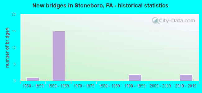
- New bridges - historical statistics
- 11950-1959
- 151960-1969
- 21990-1999
- 22010-2019

- Reconstructed bridges - Historical Statistics
- 41980-1989
- 01990-1999
- 02000-2009
- 02010-2019
- 12020-2022


- Bridge Condition - Deck
- 7.7%Excellent
- 15.4%Very good
- 7.7%Good
- 46.2%Satisfactory
- 7.7%Fair
- 7.7%Serious
- 7.7%Imminent failure

- Bridge Condition - Superstructure
- 7.7%Excellent
- 7.7%Very good
- 7.7%Good
- 23.1%Satisfactory
- 30.8%Fair
- 7.7%Poor
- 7.7%Critical
- 7.7%Imminent failure

- Bridge Condition - Substructure
- 7.7%Excellent
- 15.4%Very good
- 15.4%Good
- 30.8%Satisfactory
- 23.1%Fair
- 7.7%Poor

- Bridge Condition - Channel
- 50.0%Very good
- 20.0%Good
- 30.0%Satisfactory
Find on map >> Show street view
Structure Number: 25752, Location: LAKE TOWNSHIP (Lat: 41.351669, Lng: -80.159364), Route carried "on" structure: Interstate 79, Year Built: 1969, Year Reconstructed: 1989, Status: Open, Structure Length: 2.68m (8.79ft), Average Daily Traffic: 8,462 (year 2021), Truck Traffic: 19%, Average Future Daily Traffic: 9,924 (year 2032), Design Load: HS 20+Mod, Features Intersected: OVER SR 1008,DISTRICT RD
Minimum Vertical Clearance: 30+ m (98+ ft), Kilometerpoint: 26.775, Lanes on structure: 2, Lanes under structure: 2, Base Highway Network: Yes, Owner: State Highway Agency, Approaching Roadway Width: 7.3m (24.0ft), Skew: 10 degrees, Material/Design: Prestressed concrete, Design/Construction: Box Beam or Girders - Multiple, Number Of Spans In Main Unit: 3, Length of Maximum Span: 10.1m (33.1ft), Curb or Sidewalk Widths: Left: 0.2m (0.7ft), Right: 0.2m (0.7ft), Curb-To-Curb Width: 12.8m (42.0ft), Out-to-Out Width: 13.8m (45.3ft)
Condition: Deck: Satisfactory, Superstructure: Good, Substructure: Satisfactory, Operating Rating: 89.8 metric tons, Method Used To Determine Operating Rating: Load Factor (LF), Inventory Rating: 64.4 metric tons, Method Used To Determine Inventory Rating: Load Factor (LF), Structural Evaluation: Equal to present minimum criteria, Deck Geometry: Equal to present desirable criteria, Underclear: Somewhat better than minimum adequacy, Approach Roadway Alignment: Equal to present desirable criteria, Length Of Structure Improvement: 2.70m (8.86ft), Designated Inspection Frequency: Every 24 months, Inspection Date: November 2021, Deck Structure Type: Concrete Cast-file-Place, Wearing Surface/Protective System: Wearing Surface: Bituminous, Membrane: Preformed Fabric, Deck Protection: Epoxy Coated Reinforcing
Find on map >> Show street view
Structure Number: 25753, Location: LAKE TOWNSHIP (Lat: 41.351581, Lng: -80.159767), Route carried "on" structure: Interstate 79, Year Built: 1969, Year Reconstructed: 1989, Status: Open, Structure Length: 2.68m (8.79ft), Average Daily Traffic: 8,370 (year 2021), Truck Traffic: 17%, Average Future Daily Traffic: 11,306 (year 2032), Design Load: HS 20+Mod, Features Intersected: OVER SR 1008,DISTRICT RD
Minimum Vertical Clearance: 30+ m (98+ ft), Kilometerpoint: 26.770, Lanes on structure: 2, Lanes under structure: 2, Base Highway Network: Yes, Owner: State Highway Agency, Approaching Roadway Width: 7.3m (24.0ft), Skew: 10 degrees, Material/Design: Concrete, Design/Construction: Slab, Number Of Spans In Main Unit: 3, Length of Maximum Span: 10.1m (33.1ft), Curb or Sidewalk Widths: Left: 0.2m (0.7ft), Right: 0.2m (0.7ft), Curb-To-Curb Width: 13.4m (44.0ft), Out-to-Out Width: 13.9m (45.6ft)
Condition: Deck: Satisfactory, Superstructure: Satisfactory, Substructure: Good, Operating Rating: 59.0 metric tons, Method Used To Determine Operating Rating: Load Factor (LF), Inventory Rating: 31.8 metric tons, Method Used To Determine Inventory Rating: Load Factor (LF), Structural Evaluation: Equal to present minimum criteria, Deck Geometry: Superior to present desirable criteria, Underclear: Meets minimum limits, Approach Roadway Alignment: Equal to present desirable criteria, Length Of Structure Improvement: 3.40m (11.15ft), Designated Inspection Frequency: Every 24 months, Inspection Date: November 2021, Wearing Surface/Protective System: Wearing Surface: Bituminous, Membrane: Preformed Fabric, Deck Protection: Epoxy Coated Reinforcing
Find on map >> Show street view
Structure Number: 25754, Location: LAKE TOWNSHIP (Lat: 41.368906, Lng: -80.157006), Route carried "on" structure: Interstate 79, Year Built: 1969, Year Reconstructed: 1989, Status: Open, Structure Length: 14.94m (49.02ft), Average Daily Traffic: 8,462 (year 2021), Truck Traffic: 19%, Average Future Daily Traffic: 9,924 (year 2032), Design Load: HS 20+Mod, Features Intersected: OVER LT SHENANGO R & RR
Minimum Vertical Clearance: 30+ m (98+ ft), Kilometerpoint: 29.150, Lanes on structure: 2, Base Highway Network: Yes, Owner: State Highway Agency, Approaching Roadway Width: 7.3m (24.0ft), Skew: 10 degrees, Material/Design: Prestressed concrete, Design/Construction: Box Beam or Girders - Single/Spread, Number Of Spans In Main Unit: 8, Length of Maximum Span: 19.5m (64.0ft), Curb or Sidewalk Widths: Left: 0.2m (0.7ft), Right: 0.2m (0.7ft), Curb-To-Curb Width: 10.7m (35.1ft), Out-to-Out Width: 11.4m (37.4ft)
Condition: Deck: Satisfactory, Superstructure: Fair, Substructure: Satisfactory, Channel: Very good, Operating Rating: 89.8 metric tons, Method Used To Determine Operating Rating: Load Factor (LF), Inventory Rating: 30.8 metric tons, Method Used To Determine Inventory Rating: Load Factor (LF), Structural Evaluation: Somewhat better than minimum adequacy, Deck Geometry: Meets minimum limits, Underclear: High priority of corrective action, Waterway Adequacy: Superior to present desirable criteria, Approach Roadway Alignment: Equal to present desirable criteria, Length Of Structure Improvement: 15.80m (51.84ft), Designated Inspection Frequency: Every 24 months, Inspection Date: June 2020, Bridge Improvement Cost: $57,000, Roadway Improvement Cost: $168,000, Total Project Cost: $770,000, Deck Structure Type: Concrete Cast-file-Place, Wearing Surface/Protective System: Wearing Surface: Bituminous, Membrane: Preformed Fabric, Deck Protection: Epoxy Coated Reinforcing
Find on map >> Show street view
Structure Number: 25755, Location: LAKE TOWNSHIP (Lat: 41.369019, Lng: -80.157392), Route carried "on" structure: Interstate 79, Year Built: 1969, Year Reconstructed: 1989, Status: Open, Structure Length: 14.39m (47.21ft), Average Daily Traffic: 8,370 (year 2021), Truck Traffic: 17%, Average Future Daily Traffic: 11,306 (year 2032), Design Load: HS 20+Mod, Features Intersected: OVER LT SHENANGO R & RR
Minimum Vertical Clearance: 30+ m (98+ ft), Kilometerpoint: 29.165, Lanes on structure: 2, Base Highway Network: Yes, Owner: State Highway Agency, Approaching Roadway Width: 7.3m (24.0ft), Skew: 10 degrees, Material/Design: Prestressed concrete, Design/Construction: Box Beam or Girders - Single/Spread, Number Of Spans In Main Unit: 8, Length of Maximum Span: 19.5m (64.0ft), Curb or Sidewalk Widths: Left: 0.2m (0.7ft), Right: 0.2m (0.7ft), Curb-To-Curb Width: 10.7m (35.1ft), Out-to-Out Width: 11.4m (37.4ft)
Condition: Deck: Good, Superstructure: Fair, Substructure: Satisfactory, Channel: Very good, Operating Rating: 89.8 metric tons, Method Used To Determine Operating Rating: Load Factor (LF), Inventory Rating: 26.3 metric tons, Method Used To Determine Inventory Rating: Load Factor (LF), Structural Evaluation: Somewhat better than minimum adequacy, Deck Geometry: Meets minimum limits, Underclear: High priority of corrective action, Waterway Adequacy: Superior to present desirable criteria, Approach Roadway Alignment: Equal to present desirable criteria, Length Of Structure Improvement: 15.30m (50.20ft), Designated Inspection Frequency: Every 24 months, Inspection Date: June 2020, Bridge Improvement Cost: $55,000, Roadway Improvement Cost: $163,000, Total Project Cost: $745,000, Deck Structure Type: Concrete Cast-file-Place, Wearing Surface/Protective System: Wearing Surface: Bituminous, Membrane: Preformed Fabric, Deck Protection: Epoxy Coated Reinforcing
Find on map >> Show street view
Structure Number: 25879, Location: NEW VERNON TOWNSHIP (Lat: 41.385422, Lng: -80.159186), Route carried "on" structure: State highway 358, Year Built: 1969, Status: Open, Structure Length: 9.14m (29.99ft), Average Daily Traffic: 2,318 (year 2020), Truck Traffic: 18%, Average Future Daily Traffic: 3,473 (year 2032), Design Load: HS 20, Features Intersected: OVER SR 79,NB/SB
Minimum Vertical Clearance: 30+ m (98+ ft), Kilometerpoint: 31.353, Lanes on structure: 2, Lanes under structure: 8, Base Highway Network: Yes, Owner: State Highway Agency, Approaching Roadway Width: 9.8m (32.2ft), Skew: 3 degrees, Material/Design: Prestressed concrete, Design/Construction: Box Beam or Girders - Multiple, Number Of Spans In Main Unit: 3, Number Of Approach Spans: 2, Length of Maximum Span: 23.2m (76.1ft), Curb or Sidewalk Widths: Left: 0.5m (1.6ft), Right: 0.5m (1.6ft), Curb-To-Curb Width: 9.8m (32.2ft), Out-to-Out Width: 11.4m (37.4ft)
Condition: Deck: Satisfactory, Superstructure: Fair, Substructure: Fair, Operating Rating: 63.5 metric tons, Method Used To Determine Operating Rating: Load Factor (LF), Inventory Rating: 39.0 metric tons, Method Used To Determine Inventory Rating: Load Factor (LF), Structural Evaluation: Somewhat better than minimum adequacy, Deck Geometry: Meets minimum limits, Underclear: Somewhat better than minimum adequacy, Approach Roadway Alignment: Better than present minimum criteria, Length Of Structure Improvement: 9.10m (29.86ft), Designated Inspection Frequency: Every 24 months, Inspection Date: September 2020, Bridge Improvement Cost: $8,000, Roadway Improvement Cost: $24,000, Total Project Cost: $109,000, Deck Structure Type: Concrete Cast-file-Place, Wearing Surface/Protective System: Wearing Surface: Bituminous, Membrane: Preformed Fabric
Find on map >> Show street view
Structure Number: 2591, Location: LAKE TOWNSHIP (Lat: 41.332175, Lng: -80.159331), Route carried "on" structure: State highway , Year Built: 1967, Year Reconstructed: 2020, Status: Open, Structure Length: 6.95m (22.80ft), Average Daily Traffic: 438 (year 2022), Truck Traffic: 4%, Average Future Daily Traffic: 555 (year 2032), Design Load: HS 20, Features Intersected: OVER SR 79,NB/SB, Facility Carried by Structure: SR 1004,STONEBORO
Minimum Vertical Clearance: 30+ m (98+ ft), Kilometerpoint: 3.383, Lanes on structure: 2, Lanes under structure: 8, Owner: State Highway Agency, Approaching Roadway Width: 6.1m (20.0ft), Material/Design: Prestressed concrete, Design/Construction: Box Beam or Girders - Single/Spread, Number Of Spans In Main Unit: 5, Length of Maximum Span: 18.0m (59.1ft), Curb or Sidewalk Widths: Left: 0.5m (1.6ft), Right: 0.5m (1.6ft), Curb-To-Curb Width: 8.5m (27.9ft), Out-to-Out Width: 10.2m (33.5ft)
Condition: Deck: Fair, Superstructure: Satisfactory, Substructure: Fair, Operating Rating: 50.8 metric tons, Method Used To Determine Operating Rating: Load Factor (LF), Inventory Rating: 29.9 metric tons, Method Used To Determine Inventory Rating: Load Factor (LF), Structural Evaluation: Somewhat better than minimum adequacy, Deck Geometry: Somewhat better than minimum adequacy, Underclear: Somewhat better than minimum adequacy, Approach Roadway Alignment: Better than present minimum criteria, Length Of Structure Improvement: 7.90m (25.92ft), Designated Inspection Frequency: Every 24 months, Inspection Date: April 2020, Bridge Improvement Cost: $13,000, Roadway Improvement Cost: $37,000, Total Project Cost: $171,000, Deck Structure Type: Concrete Cast-file-Place, Wearing Surface/Protective System: Wearing Surface: Bituminous
Find on map >> Show street view
Structure Number: 26176, Location: HUTCHISON RD.LAKE TWP. (Lat: 41.358086, Lng: -80.140464), Route carried "on" structure: City street 7213, Year Built: 1965, Status: Closed, Structure Length: 0.76m (2.49ft), Average Daily Traffic: 24 (year 2019), Truck Traffic: 4%, Average Future Daily Traffic: 30 (year 2039), Design Load: HS 20, Features Intersected: OVER LITTLE SHENANGO BR., Facility Carried by Structure: BRIDGE 1606,T-661
Minimum Vertical Clearance: 30+ m (98+ ft), Kilometerpoint: 0.000, Lanes on structure: 2, Owner: County Highway Agency, Approaching Roadway Width: 6.7m (22.0ft), Material/Design: Steel, Design/Construction: Stringer/Multi-beam, Number Of Spans In Main Unit: 1, Length of Maximum Span: 7.0m (23.0ft), Curb-To-Curb Width: 9.1m (29.9ft), Out-to-Out Width: 9.8m (32.2ft)
Condition: Deck: Satisfactory, Superstructure: Critical, Substructure: Fair, Channel: Satisfactory, Operating Rating: 27.2 metric tons, Method Used To Determine Operating Rating: Load Factor (LF), Inventory Rating: 16.3 metric tons, Method Used To Determine Inventory Rating: Load Factor (LF), Structural Evaluation: High priority of replacement, Deck Geometry: Better than present minimum criteria, Waterway Adequacy: Equal to present desirable criteria, Approach Roadway Alignment: Equal to present desirable criteria, Bridge Posting: Required (Relationship of Operating Rating to Maximum Legal Load: > 39.9% below), Length Of Structure Improvement: 0.80m (2.62ft), Designated Inspection Frequency: Every 24 months, Inspection Date: May 2020, Total Project Cost: $845,000 ( Estimate for 2014), Deck Structure Type: Open Grating
Find on map >> Show street view
Structure Number: 26179, Location: CANON RD.,LAKE TOWNSHIP (Lat: 41.368631, Lng: -80.154378), Route carried "on" structure: City street 7213, Year Built: 1997, Status: Open, Structure Length: 1.01m (3.31ft), Average Daily Traffic: 813 (year 2019), Truck Traffic: 40%, Average Future Daily Traffic: 1,140 (year 2039), Design Load: HS 25 or greater, Features Intersected: OVER LITTLE SHENANGO, Facility Carried by Structure: BRIDGE 1601,T-762
Minimum Vertical Clearance: 30+ m (98+ ft), Kilometerpoint: 0.000, Lanes on structure: 2, Owner: County Highway Agency, Approaching Roadway Width: 8.5m (27.9ft), Skew: 2 degrees, Material/Design: Prestressed concrete, Design/Construction: Box Beam or Girders - Multiple, Number Of Spans In Main Unit: 1, Length of Maximum Span: 9.4m (30.8ft), Curb-To-Curb Width: 8.5m (27.9ft), Out-to-Out Width: 9.1m (29.9ft)
Condition: Deck: Very good, Superstructure: Satisfactory, Substructure: Very good, Channel: Very good, Operating Rating: 89.8 metric tons, Method Used To Determine Operating Rating: Load Factor (LF), Inventory Rating: 50.8 metric tons, Method Used To Determine Inventory Rating: Load Factor (LF), Structural Evaluation: Equal to present minimum criteria, Deck Geometry: Somewhat better than minimum adequacy, Waterway Adequacy: Equal to present desirable criteria, Approach Roadway Alignment: Equal to present desirable criteria, Length Of Structure Improvement: 1.20m (3.94ft), Designated Inspection Frequency: Every 24 months, Inspection Date: July 2021, Deck Structure Type: Other, Wearing Surface/Protective System: Wearing Surface: Bituminous, Membrane: Preformed Fabric
Find on map >> Show street view
Structure Number: 262, Location: SHELL ROAD,NEW VERNON TWP (Lat: 41.371600, Lng: -80.154300), Route carried "on" structure: City street 7216, Year Built: 1994, Status: Open, Structure Length: 0.67m (2.20ft), Average Daily Traffic: 61 (year 2019), Truck Traffic: 4%, Average Future Daily Traffic: 90 (year 2039), Design Load: HS 25 or greater, Features Intersected: OVER LITTLE SHENANGO BR., Facility Carried by Structure: BRIDGE 1112,T-695
Minimum Vertical Clearance: 30+ m (98+ ft), Kilometerpoint: 0.000, Lanes on structure: 2, Owner: County Highway Agency, Approaching Roadway Width: 7.3m (24.0ft), Material/Design: Concrete, Design/Construction: Culvert, Number Of Spans In Main Unit: 1, Length of Maximum Span: 6.1m (20.0ft), Curb-To-Curb Width: 7.5m (24.6ft), Out-to-Out Width: 8.2m (26.9ft)
Condition: Channel: Very good, Culverts: Very good, Operating Rating: 64.4 metric tons, Method Used To Determine Operating Rating: Load Factor (LF), Inventory Rating: 38.1 metric tons, Method Used To Determine Inventory Rating: Load Factor (LF), Structural Evaluation: Equal to present desirable criteria, Deck Geometry: Equal to present minimum criteria, Waterway Adequacy: Equal to present desirable criteria, Approach Roadway Alignment: Equal to present desirable criteria, Length Of Structure Improvement: 0.70m (2.30ft), Designated Inspection Frequency: Every 24 months, Inspection Date: June 2021
Find on map >> Show street view
Structure Number: 26201, Location: CAREY RD.,NEW VERNON TWP. (Lat: 41.375419, Lng: -80.175319), Route carried "on" structure: City street 7216, Year Built: 1958, Status: Open, Structure Length: 1.34m (4.40ft), Average Daily Traffic: 29 (year 2019), Truck Traffic: 4%, Average Future Daily Traffic: 40 (year 2039), Design Load: HS 20, Features Intersected: OVER PINE RUN, Facility Carried by Structure: BRIDGE 1110,T-738
Minimum Vertical Clearance: 30+ m (98+ ft), Kilometerpoint: 0.000, Lanes on structure: 2, Owner: County Highway Agency, Approaching Roadway Width: 4.9m (16.1ft), Skew: 2 degrees, Material/Design: Steel, Design/Construction: Stringer/Multi-beam, Number Of Spans In Main Unit: 1, Length of Maximum Span: 12.2m (40.0ft), Curb-To-Curb Width: 7.3m (24.0ft), Out-to-Out Width: 7.9m (25.9ft)
Condition: Deck: Satisfactory, Superstructure: Fair, Substructure: Good, Channel: Satisfactory, Operating Rating: 54.4 metric tons, Method Used To Determine Operating Rating: Load Factor (LF), Inventory Rating: 32.7 metric tons, Method Used To Determine Inventory Rating: Load Factor (LF), Structural Evaluation: Somewhat better than minimum adequacy, Deck Geometry: Equal to present minimum criteria, Waterway Adequacy: Equal to present desirable criteria, Approach Roadway Alignment: Somewhat better than minimum adequacy, Length Of Structure Improvement: 1.30m (4.27ft), Designated Inspection Frequency: Every 24 months, Inspection Date: June 2021, Deck Structure Type: Open Grating
Find on map >> Show street view
Structure Number: 26202, Location: CARPENTER RD. NEW VERNON (Lat: 41.373269, Lng: -80.167144), Route carried "on" structure: City street 7216, Year Built: 1961, Status: Open, Structure Length: 2.29m (7.51ft), Average Daily Traffic: 81 (year 2019), Truck Traffic: 4%, Average Future Daily Traffic: 110 (year 2039), Design Load: HS 20, Features Intersected: OVER LITTLE SHENANGO, Facility Carried by Structure: BRIDGE 1111,T-760
Minimum Vertical Clearance: 30+ m (98+ ft), Kilometerpoint: 0.000, Lanes on structure: 2, Owner: County Highway Agency, Approaching Roadway Width: 5.5m (18.0ft), Material/Design: Steel, Design/Construction: Stringer/Multi-beam, Number Of Spans In Main Unit: 1, Length of Maximum Span: 21.9m (71.9ft), Curb-To-Curb Width: 7.3m (24.0ft), Out-to-Out Width: 7.9m (25.9ft)
Condition: Deck: Serious, Superstructure: Poor, Substructure: Satisfactory, Channel: Good, Operating Rating: 71.7 metric tons, Method Used To Determine Operating Rating: Load Factor (LF), Inventory Rating: 42.6 metric tons, Method Used To Determine Inventory Rating: Load Factor (LF), Structural Evaluation: Meets minimum limits, Deck Geometry: Equal to present minimum criteria, Waterway Adequacy: Equal to present desirable criteria, Approach Roadway Alignment: Equal to present desirable criteria, Length Of Structure Improvement: 2.30m (7.55ft), Designated Inspection Frequency: Every 24 months, Other Special Inspection Frequency: Every 6 months, Inspection Date: June 2021, Other Special Inspection Date: June 2021, Deck Structure Type: Open Grating
Find on map >> Show street view
Structure Number: 26214, Location: YEAGER RD, PERRY TOWNSHIP (Lat: 41.374328, Lng: -80.180811), Route carried "on" structure: City street 7218, Year Built: 1961, Status: Closed, Structure Length: 1.04m (3.41ft), Average Daily Traffic: 31 (year 2018), Truck Traffic: 4%, Average Future Daily Traffic: 40 (year 2038), Design Load: HS 20, Features Intersected: OVER PINE RUN, Facility Carried by Structure: BRIDGE 1017,T-693
Minimum Vertical Clearance: 30+ m (98+ ft), Kilometerpoint: 0.000, Lanes on structure: 2, Owner: County Highway Agency, Approaching Roadway Width: 5.8m (19.0ft), Material/Design: Steel, Design/Construction: Stringer/Multi-beam, Number Of Spans In Main Unit: 1, Length of Maximum Span: 9.8m (32.2ft), Curb-To-Curb Width: 7.3m (24.0ft), Out-to-Out Width: 7.9m (25.9ft)
Condition: Deck: Imminent failure, Superstructure: Imminent failure, Substructure: Poor, Channel: Good, Operating Rating: 19.1 metric tons, Method Used To Determine Operating Rating: Load Factor (LF), Inventory Rating: 10.9 metric tons, Method Used To Determine Inventory Rating: Load Factor (LF), Deck Geometry: Equal to present minimum criteria, Waterway Adequacy: Equal to present desirable criteria, Approach Roadway Alignment: Equal to present desirable criteria, Bridge Posting: Required (Relationship of Operating Rating to Maximum Legal Load: > 39.9% below), Length Of Structure Improvement: 1.00m (3.28ft), Designated Inspection Frequency: Every 24 months, Inspection Date: June 2021, Total Project Cost: $1,000,000 ( Estimate for 2014), Deck Structure Type: Open Grating
Find on map >> Show street view
Structure Number: 46165, Location: WORTH TWP (Lat: 41.275475, Lng: -80.072625), Route carried "on" structure: State highway 173, Year Built: 2010, Status: Open, Structure Length: 1.95m (6.40ft), Average Daily Traffic: 1,667 (year 2022), Truck Traffic: 13%, Average Future Daily Traffic: 1,834 (year 2032), Design Load: HL 93, Features Intersected: WOLF CREEK BRANCH
Minimum Vertical Clearance: 30+ m (98+ ft), Kilometerpoint: 19.148, Lanes on structure: 2, Owner: State Highway Agency, Approaching Roadway Width: 7.9m (25.9ft), Material/Design: Prestressed concrete, Design/Construction: Box Beam or Girders - Single/Spread, Number Of Spans In Main Unit: 1, Length of Maximum Span: 18.3m (60.0ft), Curb or Sidewalk Widths: Left: 0.1m (0.3ft), Right: 0.1m (0.3ft), Curb-To-Curb Width: 9.8m (32.2ft), Out-to-Out Width: 10.8m (35.4ft)
Condition: Deck: Very good, Superstructure: Very good, Substructure: Very good, Channel: Very good, Operating Rating: 68.0 metric tons, Method Used To Determine Operating Rating: Load and Resistance Factor (LRFR), Inventory Rating: 41.7 metric tons, Method Used To Determine Inventory Rating: Load and Resistance Factor (LRFR), Structural Evaluation: Equal to present desirable criteria, Deck Geometry: Somewhat better than minimum adequacy, Waterway Adequacy: Superior to present desirable criteria, Approach Roadway Alignment: Equal to present desirable criteria, Designated Inspection Frequency: Every 48 months, Inspection Date: May 2019, Deck Structure Type: Concrete Cast-file-Place, Wearing Surface/Protective System: Wearing Surface: Monolithic Concrete, Deck Protection: Epoxy Coated Reinforcing
Find on map >> Show street view
Structure Number: 54382, Location: PARKER ROAD LAKE TWP (Lat: 41.304294, Lng: -80.110247), Route carried "on" structure: County highway 613, Year Built: 2017, Status: Open, Structure Length: 1.25m (4.10ft), Average Daily Traffic: 46 (year 2019), Truck Traffic: 4%, Average Future Daily Traffic: 60 (year 2039), Design Load: HL 93, Features Intersected: UNK TR TO FOX RUN
Minimum Vertical Clearance: 30+ m (98+ ft), Kilometerpoint: 0.000, Lanes on structure: 2, Owner: County Highway Agency, Approaching Roadway Width: 6.7m (22.0ft), Material/Design: Prestressed concrete, Design/Construction: Box Beam or Girders - Single/Spread, Number Of Spans In Main Unit: 1, Length of Maximum Span: 11.6m (38.1ft), Curb or Sidewalk Widths: Left: 0.1m (0.3ft), Right: 0.1m (0.3ft), Curb-To-Curb Width: 6.7m (22.0ft), Out-to-Out Width: 7.7m (25.3ft)
Condition: Deck: Excellent, Superstructure: Excellent, Substructure: Excellent, Channel: Satisfactory, Operating Rating: 53.5 metric tons, Method Used To Determine Operating Rating: Assigned ratings based on Load and Resistance Factor Design (LRFD) reported by rating factor (RF) using HL93 loadings, Inventory Rating: 33.7 metric tons, Method Used To Determine Inventory Rating: Assigned ratings based on Load and Resistance Factor Design (LRFD) reported by rating factor (RF) using HL93 loadings, Structural Evaluation: Superior to present desirable criteria, Deck Geometry: Somewhat better than minimum adequacy, Waterway Adequacy: Equal to present desirable criteria, Approach Roadway Alignment: Equal to present desirable criteria, Designated Inspection Frequency: Every 24 months, Inspection Date: November 2019, Deck Structure Type: Concrete Cast-file-Place, Wearing Surface/Protective System: Wearing Surface: Monolithic Concrete, Deck Protection: Epoxy Coated Reinforcing
Find on map >> Show street view
Structure Number: 25752, Location: LAKE TOWNSHIP (Lat: 41.351669, Lng: -80.159364), Route carried "under" structure: State highway , Year Built: 1969, Structure Length: 0. m, Average Daily Traffic: 782 (year 2020), Truck Traffic: 7%, Features Intersected: OVER SR 1008,DISTRICT RD, Facility Carried by Structure: SR 79,NB
Minimum Vertical Clearance: 4.35m (14.27ft), Kilometerpoint: 14.708, Lanes on structure: 2, Lanes under structure: 2, Material/Design: Prestressed concrete, Design/Construction: Box Beam or Girders - Multiple, Length of Maximum Span: 10.1m (33.1ft)
Find on map >> Show street view
Structure Number: 25753, Location: LAKE TOWNSHIP (Lat: 41.351581, Lng: -80.159767), Route carried "under" structure: State highway , Year Built: 1969, Structure Length: 0. m, Average Daily Traffic: 782 (year 2020), Truck Traffic: 7%, Features Intersected: OVER SR 1008,DISTRICT RD, Facility Carried by Structure: SR 79,SB
Minimum Vertical Clearance: 4.27m (14.01ft), Kilometerpoint: 14.708, Lanes on structure: 2, Lanes under structure: 2, Material/Design: Concrete, Design/Construction: Slab, Length of Maximum Span: 10.1m (33.1ft)
Find on map >> Show street view
Structure Number: 25879, Location: NEW VERNON TOWNSHIP (Lat: 41.385422, Lng: -80.159186), Route carried "under" structure: Interstate 79, Year Built: 1969, Structure Length: 0. m, Average Daily Traffic: 6,543 (year 2021), Truck Traffic: 32%, Features Intersected: OVER SR 79,NB/SB, Facility Carried by Structure: SR 358,HADLEY ROAD
Minimum Vertical Clearance: 5.18m (16.99ft), Kilometerpoint: 30.793, Lanes on structure: 2, Lanes under structure: 4, Material/Design: Prestressed concrete, Design/Construction: Box Beam or Girders - Multiple, Length of Maximum Span: 23.2m (76.1ft)
Find on map >> Show street view
Structure Number: 25879, Location: NEW VERNON TOWNSHIP (Lat: 41.385422, Lng: -80.159186), Route carried "under" structure: Interstate 79, Year Built: 1969, Structure Length: 0. m, Average Daily Traffic: 7,035 (year 2021), Truck Traffic: 37%, Features Intersected: OVER SR 79,NB/SB, Facility Carried by Structure: SR 358,HADLEY ROAD
Minimum Vertical Clearance: 5.00m (16.40ft), Kilometerpoint: 30.800, Lanes on structure: 2, Lanes under structure: 4, Material/Design: Prestressed concrete, Design/Construction: Box Beam or Girders - Multiple, Length of Maximum Span: 23.2m (76.1ft)
Find on map >> Show street view
Structure Number: 2591, Location: LAKE TOWNSHIP (Lat: 41.332175, Lng: -80.159331), Route carried "under" structure: Interstate 79, Year Built: 1967, Structure Length: 0. m, Average Daily Traffic: 8,370 (year 2021), Truck Traffic: 17%, Features Intersected: OVER SR 79,NB/SB, Facility Carried by Structure: SR 1004,STONEBORO
Minimum Vertical Clearance: 5.03m (16.50ft), Kilometerpoint: 24.351, Lanes on structure: 2, Lanes under structure: 4, Material/Design: Prestressed concrete, Design/Construction: Box Beam or Girders - Single/Spread, Length of Maximum Span: 18.0m (59.1ft)
Find on map >> Show street view
Structure Number: 2591, Location: LAKE TOWNSHIP (Lat: 41.332175, Lng: -80.159331), Route carried "under" structure: Interstate 79, Year Built: 1967, Structure Length: 0. m, Average Daily Traffic: 8,462 (year 2021), Truck Traffic: 19%, Features Intersected: OVER SR 79,NB/SB, Facility Carried by Structure: SR 1004,STONEBORO
Minimum Vertical Clearance: 5.00m (16.40ft), Kilometerpoint: 24.362, Lanes on structure: 2, Lanes under structure: 4, Material/Design: Prestressed concrete, Design/Construction: Box Beam or Girders - Single/Spread, Length of Maximum Span: 18.0m (59.1ft)