Bridge Statistics for Stockton, Wisconsin (WI)
Condition, Traffic, Stress, Structural Evaluation, Project Costs
- National Bridge Inventory (NBI) Statistics
- 10Number of bridges
- 144ft / 43.5mTotal length
- 42,687Total average daily traffic
- 248Total average daily truck traffic
- National Bridge Inventory (NBI) Registered Bridges for Stockton
- No street view available for this location
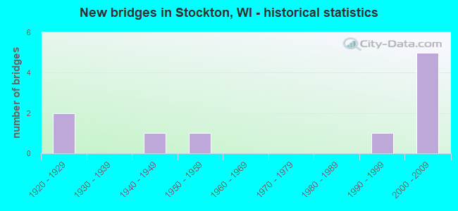
- New bridges - historical statistics
- 21920-1929
- 11940-1949
- 11950-1959
- 11990-1999
- 52000-2009


- Bridge Condition - Superstructure
- 50.0%Very good
- 50.0%Good

- Bridge Condition - Substructure
- 75.0%Good
- 25.0%Satisfactory
Find on map >> Show street view
Structure Number: B49009, Location: 1.0M E JCT CTH P (Lat: 44.500669, Lng: -89.596167), Route carried "on" structure: County highway , Year Built: 1999, Status: Open, Structure Length: 23.72m (77.82ft), Average Daily Traffic: 4,180 (year 2019), Average Future Daily Traffic: 4,598 (year 2039), Design Load: HS 20, Features Intersected: WISCONSIN RIVER, Facility Carried by Structure: CTH HH
Minimum Vertical Clearance: 30+ m (98+ ft), Kilometerpoint: 0.000, Lanes on structure: 4, Owner: County Highway Agency, Approaching Roadway Width: 25.3m (83.0ft), Material/Design: Prestressed concrete continuous, Design/Construction: Stringer/Multi-beam, Number Of Spans In Main Unit: 7, Length of Maximum Span: 34.0m (111.5ft), Curb or Sidewalk Widths: Left: 2.3m (7.5ft), Right: 0.0m, Curb-To-Curb Width: 17.6m (57.7ft), Out-to-Out Width: 23.7m (77.8ft)
Condition: Deck: Good, Superstructure: Good, Substructure: Satisfactory, Channel: Satisfactory, Operating Rating: 67.0 metric tons, Method Used To Determine Operating Rating: Load Factor (LF), Inventory Rating: 35.6 metric tons, Method Used To Determine Inventory Rating: Load Factor (LF), Structural Evaluation: Equal to present minimum criteria, Deck Geometry: Somewhat better than minimum adequacy, Waterway Adequacy: Equal to present desirable criteria, Approach Roadway Alignment: Equal to present desirable criteria, Designated Inspection Frequency: Every 24 months, Underwater Inspection Frequency: Every 60 months, Inspection Date: May 2020, Underwater Inspection Date: July 2020, Deck Structure Type: Concrete Cast-file-Place, Wearing Surface/Protective System: Wearing Surface: Monolithic Concrete, Deck Protection: Epoxy Coated Reinforcing
Find on map >> Show street view
Structure Number: B490095, Location: TOWN OF STOCKTON (Lat: 44.520800, Lng: -89.446344), Route carried "on" structure: County highway , Year Built: 2001, Status: Open, Structure Length: 7.00m (22.97ft), Average Daily Traffic: 2,700 (year 2019), Average Future Daily Traffic: 5,100 (year 2039), Design Load: HS 20, Features Intersected: USH 10, Facility Carried by Structure: CTH J NB
Minimum Vertical Clearance: 30+ m (98+ ft), Kilometerpoint: 0.000, Lanes on structure: 2, Lanes under structure: 5, Owner: State Highway Agency, Approaching Roadway Width: 9.4m (30.8ft), Material/Design: Prestressed concrete continuous, Design/Construction: Stringer/Multi-beam, Number Of Spans In Main Unit: 2, Length of Maximum Span: 35.7m (117.1ft), Curb-To-Curb Width: 10.5m (34.4ft), Out-to-Out Width: 11.4m (37.4ft)
Condition: Deck: Good, Superstructure: Very good, Substructure: Good, Operating Rating: 73.0 metric tons, Method Used To Determine Operating Rating: Load Factor (LF), Inventory Rating: 38.9 metric tons, Method Used To Determine Inventory Rating: Load Factor (LF), Structural Evaluation: Better than present minimum criteria, Deck Geometry: Somewhat better than minimum adequacy, Underclear: Superior to present desirable criteria, Approach Roadway Alignment: Equal to present desirable criteria, Designated Inspection Frequency: Every 48 months, Inspection Date: July 2020, Deck Structure Type: Concrete Cast-file-Place, Wearing Surface/Protective System: Wearing Surface: Monolithic Concrete, Deck Protection: Epoxy Coated Reinforcing
Find on map >> Show street view
Structure Number: B490096, Location: TOWN OF STOCKTON (Lat: 44.521439, Lng: -89.446647), Route carried "on" structure: County highway , Year Built: 2001, Status: Open, Structure Length: 7.00m (22.97ft), Average Daily Traffic: 3,100 (year 2019), Average Future Daily Traffic: 5,100 (year 2039), Design Load: HS 20, Features Intersected: USH 10, Facility Carried by Structure: CTH J SB
Minimum Vertical Clearance: 30+ m (98+ ft), Kilometerpoint: 0.000, Lanes on structure: 2, Lanes under structure: 6, Owner: State Highway Agency, Approaching Roadway Width: 9.4m (30.8ft), Material/Design: Prestressed concrete continuous, Design/Construction: Stringer/Multi-beam, Number Of Spans In Main Unit: 2, Length of Maximum Span: 35.7m (117.1ft), Curb-To-Curb Width: 10.5m (34.4ft), Out-to-Out Width: 11.4m (37.4ft)
Condition: Deck: Good, Superstructure: Very good, Substructure: Good, Operating Rating: 73.0 metric tons, Method Used To Determine Operating Rating: Load Factor (LF), Inventory Rating: 38.9 metric tons, Method Used To Determine Inventory Rating: Load Factor (LF), Structural Evaluation: Better than present minimum criteria, Deck Geometry: Somewhat better than minimum adequacy, Underclear: Superior to present desirable criteria, Approach Roadway Alignment: Equal to present desirable criteria, Designated Inspection Frequency: Every 48 months, Inspection Date: July 2020, Deck Structure Type: Concrete Cast-file-Place, Wearing Surface/Protective System: Wearing Surface: Monolithic Concrete, Deck Protection: Epoxy Coated Reinforcing
Find on map >> Show street view
Structure Number: B490164, Location: 0.35 M S JCT USH 10 (Lat: 44.513028, Lng: -89.446083), Route carried "on" structure: County highway , Year Built: 2008, Status: Open, Structure Length: 5.03m (16.50ft), Average Daily Traffic: 4,140 (year 2019), Truck Traffic: 6%, Average Future Daily Traffic: 4,554 (year 2035), Design Load: HS 25 or greater, Features Intersected: CANADIAN NATIONAL RR, Facility Carried by Structure: CTH J
Minimum Vertical Clearance: 30+ m (98+ ft), Kilometerpoint: 0.000, Lanes on structure: 2, Owner: County Highway Agency, Approaching Roadway Width: 12.2m (40.0ft), Skew: 1 degrees, Material/Design: Prestressed concrete continuous, Design/Construction: Stringer/Multi-beam, Number Of Spans In Main Unit: 3, Length of Maximum Span: 19.7m (64.6ft), Curb-To-Curb Width: 12.2m (40.0ft), Out-to-Out Width: 13.0m (42.7ft)
Condition: Deck: Good, Superstructure: Good, Substructure: Good, Operating Rating: 83.3 metric tons, Method Used To Determine Operating Rating: Load Factor (LF), Inventory Rating: 45.4 metric tons, Method Used To Determine Inventory Rating: Load Factor (LF), Structural Evaluation: Better than present minimum criteria, Deck Geometry: Equal to present minimum criteria, Underclear: Superior to present desirable criteria, Approach Roadway Alignment: Equal to present desirable criteria, Designated Inspection Frequency: Every 48 months, Inspection Date: August 2019, Deck Structure Type: Concrete Cast-file-Place, Wearing Surface/Protective System: Wearing Surface: Monolithic Concrete, Deck Protection: Epoxy Coated Reinforcing
Find on map >> Show street view
Structure Number: P490901, Location: 0.8M E JCT STH 161 (Lat: 44.475564, Lng: -89.295236), Route carried "on" structure: City street , Year Built: 1950, Status: Open, Structure Length: 0.76m (2.49ft), Average Daily Traffic: 47 (year 2019), Average Future Daily Traffic: 51 (year 2039), Design Load: H 15, Features Intersected: TOMORROW RIVER, Facility Carried by Structure: LRD LAKE MEYERS RD
Minimum Vertical Clearance: 30+ m (98+ ft), Kilometerpoint: 0.000, Lanes on structure: 2, Owner: Town or Township Highway Agency, Approaching Roadway Width: 6.7m (22.0ft), Material/Design: Concrete, Design/Construction: Culvert, Number Of Spans In Main Unit: 4, Length of Maximum Span: 1.5m (4.9ft)
Condition: Channel: Satisfactory, Culverts: Fair, Operating Rating: 53.9 metric tons, Method Used To Determine Operating Rating: Field evaluation and documented engineering judgment, Inventory Rating: 24.3 metric tons, Method Used To Determine Inventory Rating: Field evaluation and documented engineering judgment, Structural Evaluation: Somewhat better than minimum adequacy, Waterway Adequacy: Equal to present desirable criteria, Approach Roadway Alignment: Equal to present minimum criteria, Designated Inspection Frequency: Every 24 months, Inspection Date: August 2020, Wearing Surface/Protective System: Wearing Surface: Bituminous
Find on map >> Show street view
Structure Number: B490095, Location: 6.9M E JCT USH 51 (Lat: 44.520800, Lng: -89.446344), Route carried "under" structure: US 10, Year Built: 2001, Structure Length: 0. m, Average Daily Traffic: 14,200 (year 2019), Features Intersected: USH 10, Facility Carried by Structure: CTH J NB
Minimum Vertical Clearance: 5.20m (17.06ft), Kilometerpoint: 0.000, Lanes on structure: 2, Lanes under structure: 5, Material/Design: Prestressed concrete continuous, Design/Construction: Stringer/Multi-beam, Length of Maximum Span: 35.7m (117.1ft)
Find on map >> Show street view
Structure Number: B490096, Location: 6.8M E JCT USH 51 (Lat: 44.521439, Lng: -89.446647), Route carried "under" structure: US 10, Year Built: 2001, Structure Length: 0. m, Average Daily Traffic: 14,200 (year 2019), Features Intersected: USH 10, Facility Carried by Structure: CTH J SB
Minimum Vertical Clearance: 5.68m (18.64ft), Kilometerpoint: 0.000, Lanes on structure: 2, Lanes under structure: 6, Material/Design: Prestressed concrete continuous, Design/Construction: Stringer/Multi-beam, Length of Maximum Span: 35.7m (117.1ft)
Find on map >> Show street view
Structure Number: P490044, Location: 0.2M S JCT USH 10 (Lat: 44.510433, Lng: -89.426247), Route carried "under" structure: City street , Year Built: 1940, Structure Length: 0. m, Average Daily Traffic: 40 (year 2019), Features Intersected: LRD CUSTER RD, Facility Carried by Structure: SOO LINE
Minimum Vertical Clearance: 4.27m (14.01ft), Kilometerpoint: 0.000, Lanes under structure: 1, Material/Design: Wood or Timber, Design/Construction: Stringer/Multi-beam, Length of Maximum Span: 9.1m (29.9ft)
Find on map >> Show street view
Structure Number: P490045, Location: 0.6M S JCT USH 10 (Lat: 44.511719, Lng: -89.467258), Route carried "under" structure: City street , Year Built: 1920, Structure Length: 0. m, Average Daily Traffic: 40 (year 2019), Features Intersected: LRD STOCKTON RD, Facility Carried by Structure: SOO LINE
Minimum Vertical Clearance: 3.47m (11.38ft), Kilometerpoint: 0.000, Lanes under structure: 2, Material/Design: Wood or Timber, Design/Construction: Stringer/Multi-beam, Length of Maximum Span: 10.2m (33.5ft)
Find on map >> Show street view
Structure Number: P490908, Location: 0.1M S JCT USH 10 (Lat: 44.500978, Lng: -89.387436), Route carried "under" structure: City street , Year Built: 1920, Structure Length: 0. m, Average Daily Traffic: 40 (year 2019), Features Intersected: LRD SMOKEY RD, Facility Carried by Structure: SOO LINE
Minimum Vertical Clearance: 4.45m (14.60ft), Kilometerpoint: 0.000, Lanes under structure: 2, Material/Design: Wood or Timber, Design/Construction: Stringer/Multi-beam, Length of Maximum Span: 11.6m (38.1ft)