Bridge Statistics for Sterling, Michigan (MI)
Condition, Traffic, Stress, Structural Evaluation, Project Costs
- National Bridge Inventory (NBI) Statistics
- 13Number of bridges
- 118ft / 36.1mTotal length
- $562,000Total costs
- 71,350Total average daily traffic
- 7,735Total average daily truck traffic
- National Bridge Inventory (NBI) Registered Bridges for Sterling
- No street view available for this location
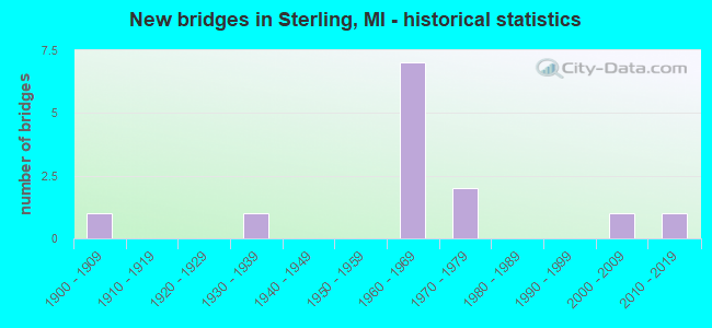
- New bridges - historical statistics
- 11900-1909
- 11930-1939
- 71960-1969
- 21970-1979
- 12000-2009
- 12010-2019

- Reconstructed bridges - Historical Statistics
- 11940-1949
- 01950-1959
- 01960-1969
- 01970-1979
- 01980-1989
- 01990-1999
- 12000-2009


- Bridge Condition - Deck
- 25.0%Very good
- 25.0%Good
- 50.0%Poor

- Bridge Condition - Superstructure
- 25.0%Very good
- 25.0%Good
- 12.5%Fair
- 37.5%Poor

- Bridge Condition - Substructure
- 25.0%Very good
- 12.5%Good
- 12.5%Satisfactory
- 37.5%Fair
- 12.5%Poor

- Bridge Condition - Channel
- 28.6%Very good
- 28.6%Good
- 42.9%Satisfactory

- Bridge Condition - Culverts
- 50.0%Satisfactory
- 50.0%Fair
Find on map >> Show street view
Structure Number: 417, Location: 0.1 MI S OF MI PT 193 (Lat: 44.012892, Lng: -84.039886), Route carried "on" structure: Interstate 75, Year Built: 1968, Status: Open, Structure Length: 0.91m (2.99ft), Average Daily Traffic: 7,138 (year 2007), Truck Traffic: 11%, Average Future Daily Traffic: 9,916 (year 2018), Design Load: HS 20+Mod, Features Intersected: N BRANCH PINE RIVER
Minimum Vertical Clearance: 30.48m (100.00ft), Kilometerpoint: 12.032, Lanes on structure: 2, Base Highway Network: Yes (Inventory Route: 106, Subroute: 3), Owner: State Highway Agency, Approaching Roadway Width: 10.9m (35.8ft), Material/Design: Steel, Design/Construction: Culvert, Number Of Spans In Main Unit: 2, Length of Maximum Span: 3.7m (12.1ft), Curb-To-Curb Width: 10.9m (35.8ft), Out-to-Out Width: 42.4m (139.1ft)
Condition: Channel: Satisfactory, Culverts: Fair, Operating Rating: 97.2 metric tons, Method Used To Determine Operating Rating: Load Factor (LF) rating reported by rating factor (RF) method using MS18 loading, Inventory Rating: 97.2 metric tons, Method Used To Determine Inventory Rating: Load Factor (LF) rating reported by rating factor (RF) method using MS18 loading, Structural Evaluation: Somewhat better than minimum adequacy, Deck Geometry: Meets minimum limits, Waterway Adequacy: Equal to present minimum criteria, Approach Roadway Alignment: Equal to present minimum criteria, Designated Inspection Frequency: Every 24 months, Inspection Date: June 2020
Find on map >> Show street view
Structure Number: 424, Location: 2.4 MI S OF STERLING (Lat: 43.998506, Lng: -84.027408), Route carried "on" structure: County highway 621, Year Built: 1968, Status: Open, Structure Length: 4.75m (15.58ft), Average Daily Traffic: 7,175 (year 2002), Truck Traffic: 13%, Average Future Daily Traffic: 9,225 (year 2024), Design Load: H 15, Features Intersected: I-75 SB, Facility Carried by Structure: LINCOLN ROAD
Minimum Vertical Clearance: 5.06m (16.60ft), Kilometerpoint: 9.721, Lanes on structure: 2, Lanes under structure: 2, Owner: State Highway Agency, Approaching Roadway Width: 12.8m (42.0ft), Skew: 3 degrees, Material/Design: Prestressed concrete, Design/Construction: Stringer/Multi-beam, Number Of Spans In Main Unit: 3, Length of Maximum Span: 20.7m (67.9ft), Curb or Sidewalk Widths: Left: 0.2m (0.7ft), Right: 0.2m (0.7ft), Curb-To-Curb Width: 9.1m (29.9ft), Out-to-Out Width: 9.8m (32.2ft)
Condition: Deck: Poor, Superstructure: Poor, Substructure: Fair, Operating Rating: 51.5 metric tons, Method Used To Determine Operating Rating: Load Factor (LF) rating reported by rating factor (RF) method using MS18 loading, Inventory Rating: 30.8 metric tons, Method Used To Determine Inventory Rating: Load Factor (LF) rating reported by rating factor (RF) method using MS18 loading, Structural Evaluation: Meets minimum limits, Deck Geometry: High priority of corrective action, Underclear: Somewhat better than minimum adequacy, Approach Roadway Alignment: Equal to present desirable criteria, Designated Inspection Frequency: Every 12 months, Inspection Date: May 2021, Deck Structure Type: Concrete Cast-file-Place, Wearing Surface/Protective System: Wearing Surface: Monolithic Concrete
Find on map >> Show street view
Structure Number: 425, Location: 2.4 MI S OF STERLING (Lat: 43.999531, Lng: -84.027425), Route carried "on" structure: County highway 621, Year Built: 1968, Status: Open, Structure Length: 4.75m (15.58ft), Average Daily Traffic: 7,175 (year 2002), Truck Traffic: 13%, Average Future Daily Traffic: 9,225 (year 2024), Design Load: H 15, Features Intersected: I-75 NB, Facility Carried by Structure: LINCOLN ROAD
Minimum Vertical Clearance: 5.05m (16.57ft), Kilometerpoint: 9.835, Lanes on structure: 2, Lanes under structure: 2, Owner: State Highway Agency, Approaching Roadway Width: 12.8m (42.0ft), Skew: 3 degrees, Material/Design: Prestressed concrete, Design/Construction: Stringer/Multi-beam, Number Of Spans In Main Unit: 3, Length of Maximum Span: 14.9m (48.9ft), Curb or Sidewalk Widths: Left: 0.2m (0.7ft), Right: 0.2m (0.7ft), Curb-To-Curb Width: 9.1m (29.9ft), Out-to-Out Width: 9.8m (32.2ft)
Condition: Deck: Poor, Superstructure: Poor, Substructure: Fair, Operating Rating: 51.5 metric tons, Method Used To Determine Operating Rating: Load Factor (LF) rating reported by rating factor (RF) method using MS18 loading, Inventory Rating: 30.8 metric tons, Method Used To Determine Inventory Rating: Load Factor (LF) rating reported by rating factor (RF) method using MS18 loading, Structural Evaluation: Meets minimum limits, Deck Geometry: High priority of corrective action, Underclear: Equal to present minimum criteria, Approach Roadway Alignment: Equal to present desirable criteria, Designated Inspection Frequency: Every 12 months, Inspection Date: May 2021, Deck Structure Type: Concrete Cast-file-Place, Wearing Surface/Protective System: Wearing Surface: Monolithic Concrete
Find on map >> Show street view
Structure Number: 426, Location: 2.0 MI W OF STERLING (Lat: 44.033244, Lng: -84.057250), Route carried "on" structure: County highway 648, Year Built: 1968, Status: Open, Structure Length: 11.70m (38.39ft), Average Daily Traffic: 14,350 (year 2002), Truck Traffic: 13%, Average Future Daily Traffic: 18,450 (year 2024), Design Load: H 15, Features Intersected: I-75, Facility Carried by Structure: STERLING ROAD
Minimum Vertical Clearance: 5.52m (18.11ft), Kilometerpoint: 3.914, Lanes on structure: 2, Lanes under structure: 4, Owner: State Highway Agency, Approaching Roadway Width: 12.8m (42.0ft), Skew: 2 degrees, Material/Design: Prestressed concrete, Design/Construction: Stringer/Multi-beam, Number Of Spans In Main Unit: 6, Length of Maximum Span: 21.6m (70.9ft), Curb-To-Curb Width: 8.7m (28.5ft), Out-to-Out Width: 9.9m (32.5ft)
Condition: Deck: Good, Superstructure: Fair, Substructure: Fair, Operating Rating: 52.2 metric tons, Method Used To Determine Operating Rating: Load Factor (LF) rating reported by rating factor (RF) method using MS18 loading, Inventory Rating: 30.8 metric tons, Method Used To Determine Inventory Rating: Load Factor (LF) rating reported by rating factor (RF) method using MS18 loading, Structural Evaluation: Somewhat better than minimum adequacy, Deck Geometry: Meets minimum limits, Underclear: Somewhat better than minimum adequacy, Approach Roadway Alignment: Equal to present desirable criteria, Designated Inspection Frequency: Every 24 months, Inspection Date: September 2020, Deck Structure Type: Concrete Cast-file-Place, Wearing Surface/Protective System: Wearing Surface: Latex Concrete
Find on map >> Show street view
Structure Number: 443, Location: 6.5 MILES N OF STANDISH (Lat: 44.080778, Lng: -83.965200), Route carried "on" structure: County highway 631, Year Built: 1977, Status: Closed, Structure Length: 5.27m (17.29ft), Average Daily Traffic: 1,200 (year 2017), Truck Traffic: 5%, Average Future Daily Traffic: 1,800 (year 2035), Design Load: HS 20+Mod, Features Intersected: RIFLE RIVER, Facility Carried by Structure: GROVE STREET
Minimum Vertical Clearance: 30.48m (100.00ft), Kilometerpoint: 11.539, Lanes on structure: 2, Owner: County Highway Agency, Approaching Roadway Width: 10.4m (34.1ft), Skew: 3 degrees, Material/Design: Prestressed concrete, Design/Construction: Box Beam or Girders - Multiple, Number Of Spans In Main Unit: 3, Length of Maximum Span: 17.3m (56.8ft), Curb-To-Curb Width: 10.4m (34.1ft), Out-to-Out Width: 11.2m (36.7ft)
Condition: Deck: Poor, Superstructure: Good, Substructure: Good, Channel: Good, Operating Rating: 60.9 metric tons, Method Used To Determine Operating Rating: Load Factor (LF) rating reported by rating factor (RF) method using MS18 loading, Inventory Rating: 36.6 metric tons, Method Used To Determine Inventory Rating: Load Factor (LF) rating reported by rating factor (RF) method using MS18 loading, Structural Evaluation: Better than present minimum criteria, Deck Geometry: Equal to present minimum criteria, Waterway Adequacy: Equal to present desirable criteria, Approach Roadway Alignment: Better than present minimum criteria, Length Of Structure Improvement: 5.24m (17.19ft), Designated Inspection Frequency: Every 12 months, Inspection Date: August 2021, Bridge Improvement Cost: $548,000, Roadway Improvement Cost: $7,000, Total Project Cost: $555,000 ( Estimate for 2017), Deck Structure Type: Concrete Cast-file-Place, Wearing Surface/Protective System: Wearing Surface: Monolithic Concrete
Find on map >> Show street view
Structure Number: 446, Location: 2.6 MILES NW OF STANDISH (Lat: 44.010000, Lng: -83.992994), Route carried "on" structure: County highway 613, Year Built: 1932, Year Reconstructed: 1945, Status: Open, Structure Length: 0.88m (2.89ft), Average Daily Traffic: 2,554 (year 2018), Average Future Daily Traffic: 3,100 (year 2038), Design Load: HS 20+Mod, Features Intersected: NORTH BR PINE RIVER, Facility Carried by Structure: OLD M-76
Minimum Vertical Clearance: 30.48m (100.00ft), Kilometerpoint: 3.624, Lanes on structure: 2, Owner: County Highway Agency, Approaching Roadway Width: 12.2m (40.0ft), Material/Design: Concrete, Design/Construction: Tee Beam, Number Of Spans In Main Unit: 1, Length of Maximum Span: 7.3m (24.0ft), Curb-To-Curb Width: 11.0m (36.1ft), Out-to-Out Width: 11.5m (37.7ft)
Condition: Deck: Poor, Superstructure: Poor, Substructure: Poor, Channel: Satisfactory, Operating Rating: 37.8 metric tons, Method Used To Determine Operating Rating: Field evaluation and documented engineering judgment, Inventory Rating: 29.4 metric tons, Method Used To Determine Inventory Rating: Field evaluation and documented engineering judgment, Structural Evaluation: Meets minimum limits, Deck Geometry: Somewhat better than minimum adequacy, Waterway Adequacy: Better than present minimum criteria, Approach Roadway Alignment: Superior to present desirable criteria, Designated Inspection Frequency: Every 12 months, Inspection Date: August 2021, Bridge Improvement Cost: $6,000, Roadway Improvement Cost: $1,000, Total Project Cost: $7,000, Deck Structure Type: Concrete Cast-file-Place, Wearing Surface/Protective System: Wearing Surface: Bituminous
Find on map >> Show street view
Structure Number: 447, Location: 3 MILES NORTH OF STERLING (Lat: 44.072833, Lng: -84.019947), Route carried "on" structure: County highway 621, Year Built: 2008, Status: Open, Structure Length: 5.49m (18.01ft), Average Daily Traffic: 2,400 (year 2006), Average Future Daily Traffic: 4,300 (year 2026), Design Load: HS 20+Mod, Features Intersected: RIFLE RIVER, Facility Carried by Structure: MELITA ROAD (M-70)
Minimum Vertical Clearance: 30.48m (100.00ft), Kilometerpoint: 18.207, Lanes on structure: 2, Owner: County Highway Agency, Approaching Roadway Width: 12.2m (40.0ft), Material/Design: Prestressed concrete, Design/Construction: Stringer/Multi-beam, Number Of Spans In Main Unit: 3, Length of Maximum Span: 30.5m (100.1ft), Curb-To-Curb Width: 12.2m (40.0ft), Out-to-Out Width: 12.9m (42.3ft)
Condition: Deck: Good, Superstructure: Very good, Substructure: Very good, Channel: Very good, Operating Rating: 77.8 metric tons, Method Used To Determine Operating Rating: Load Factor (LF) rating reported by rating factor (RF) method using MS18 loading, Inventory Rating: 46.7 metric tons, Method Used To Determine Inventory Rating: Load Factor (LF) rating reported by rating factor (RF) method using MS18 loading, Structural Evaluation: Equal to present desirable criteria, Deck Geometry: Equal to present minimum criteria, Waterway Adequacy: Equal to present desirable criteria, Approach Roadway Alignment: Better than present minimum criteria, Designated Inspection Frequency: Every 24 months, Inspection Date: August 2020, Deck Structure Type: Concrete Cast-file-Place, Wearing Surface/Protective System: Wearing Surface: Monolithic Concrete, Deck Protection: Galvanized Reinforcing
Find on map >> Show street view
Structure Number: 458, Location: 0.1 MI S OF WYATT RD (Lat: 44.010836, Lng: -83.987136), Route carried "on" structure: County highway , Year Built: 1907, Year Reconstructed: 2011, Status: Open, Structure Length: 0.88m (2.89ft), Average Daily Traffic: 226 (year 1998), Average Future Daily Traffic: 150 (year 1977), Design Load: HS 20+Mod, Features Intersected: N BR PINE RIVER, Facility Carried by Structure: HESLOP ROAD
Minimum Vertical Clearance: 30.48m (100.00ft), Kilometerpoint: 0.494, Lanes on structure: 2, Owner: County Highway Agency, Approaching Roadway Width: 7.9m (25.9ft), Material/Design: Wood or Timber, Design/Construction: Stringer/Multi-beam, Number Of Spans In Main Unit: 1, Length of Maximum Span: 8.3m (27.2ft), Curb or Sidewalk Widths: Left: 0.2m (0.7ft), Right: 0.2m (0.7ft), Curb-To-Curb Width: 5.3m (17.4ft), Out-to-Out Width: 5.7m (18.7ft)
Condition: Deck: Very good, Superstructure: Good, Substructure: Satisfactory, Channel: Good, Operating Rating: 57.7 metric tons, Method Used To Determine Operating Rating: Allowable Stress (AS) rating reported by rating factor (RF) method using MS18 loading, Inventory Rating: 41.1 metric tons, Method Used To Determine Inventory Rating: Allowable Stress (AS) rating reported by rating factor (RF) method using MS18 loading, Structural Evaluation: Equal to present minimum criteria, Deck Geometry: High priority of replacement, Waterway Adequacy: Better than present minimum criteria, Approach Roadway Alignment: Better than present minimum criteria, Designated Inspection Frequency: Every 24 months, Inspection Date: August 2020, Deck Structure Type: Wood or Timber, Wearing Surface/Protective System: Wearing Surface: Bituminous
Find on map >> Show street view
Structure Number: 13122, Location: 0.25 MI N OF M-61 (Lat: 43.986411, Lng: -84.055431), Route carried "on" structure: County highway , Year Built: 1970, Status: Open, Structure Length: 0.78m (2.56ft), Average Daily Traffic: 150 (year 1998), Average Future Daily Traffic: 173 (year 2018), Design Load: HS 20, Features Intersected: M BR PINE RIVER, Facility Carried by Structure: MAIDA ROAD
Minimum Vertical Clearance: 30.48m (100.00ft), Kilometerpoint: 0.340, Lanes on structure: 2, Owner: County Highway Agency, Approaching Roadway Width: 4.3m (14.1ft), Material/Design: Steel, Design/Construction: Culvert, Number Of Spans In Main Unit: 2, Length of Maximum Span: 3.8m (12.5ft)
Condition: Channel: Satisfactory, Culverts: Satisfactory, Operating Rating: 36.9 metric tons, Method Used To Determine Operating Rating: Load Factor (LF) rating reported by rating factor (RF) method using MS18 loading, Inventory Rating: 29.8 metric tons, Method Used To Determine Inventory Rating: Load Factor (LF) rating reported by rating factor (RF) method using MS18 loading, Structural Evaluation: Equal to present minimum criteria, Waterway Adequacy: Somewhat better than minimum adequacy, Approach Roadway Alignment: Equal to present desirable criteria, Designated Inspection Frequency: Every 24 months, Inspection Date: April 2020, Wearing Surface/Protective System: Wearing Surface: Gravel
Find on map >> Show street view
Structure Number: 1434, Location: 400 FT S OF BRENNON RD (Lat: 44.021194, Lng: -84.065539), Route carried "on" structure: County highway , Year Built: 2019, Status: Open, Structure Length: 0.71m (2.33ft), Average Daily Traffic: 430 (year 2019), Truck Traffic: 5%, Average Future Daily Traffic: 500 (year 2039), Design Load: Greater than HL93, Features Intersected: PINE RIVER, Facility Carried by Structure: 9 MILE RD
Minimum Vertical Clearance: 30.48m (100.00ft), Kilometerpoint: 4.217, Lanes on structure: 2, Owner: County Highway Agency, Approaching Roadway Width: 10.4m (34.1ft), Material/Design: Concrete, Design/Construction: Slab, Number Of Spans In Main Unit: 1, Length of Maximum Span: 6.7m (22.0ft), Curb-To-Curb Width: 11.0m (36.1ft), Out-to-Out Width: 13.2m (43.3ft)
Condition: Deck: Very good, Superstructure: Very good, Substructure: Very good, Channel: Very good, Operating Rating: 69.7 metric tons, Method Used To Determine Operating Rating: Load and Resistance Factor Rating (LRFR) rating reported by rating factor(RF) method using HL-93 loadings, Inventory Rating: 53.8 metric tons, Method Used To Determine Inventory Rating: Load and Resistance Factor Rating (LRFR) rating reported by rating factor(RF) method using HL-93 loadings, Structural Evaluation: Equal to present desirable criteria, Deck Geometry: Better than present minimum criteria, Waterway Adequacy: Superior to present desirable criteria, Approach Roadway Alignment: Somewhat better than minimum adequacy, Designated Inspection Frequency: Every 24 months, Inspection Date: August 2021, Deck Structure Type: Concrete Precast Panels, Wearing Surface/Protective System: Wearing Surface: Bituminous, Membrane: Preformed Fabric
Find on map >> Show street view
Structure Number: 424, Location: 2.4 MI S OF STERLING (Lat: 43.998506, Lng: -84.027408), Route carried "under" structure: Interstate 75, Year Built: 1968, Structure Length: 0. m, Average Daily Traffic: 7,138 (year 2007), Truck Traffic: 11%, Features Intersected: I-75 SB, Facility Carried by Structure: LINCOLN ROAD
Minimum Vertical Clearance: 4.98m (16.34ft), Kilometerpoint: 10.062, Lanes on structure: 2, Lanes under structure: 2, Material/Design: Prestressed concrete, Design/Construction: Stringer/Multi-beam, Length of Maximum Span: 20.7m (67.9ft)
Find on map >> Show street view
Structure Number: 425, Location: 2.4 MI S OF STERLING (Lat: 43.999531, Lng: -84.027425), Route carried "under" structure: Interstate 75, Year Built: 1968, Structure Length: 0. m, Average Daily Traffic: 7,138 (year 2007), Truck Traffic: 11%, Features Intersected: I-75 NB, Facility Carried by Structure: LINCOLN ROAD
Minimum Vertical Clearance: 5.05m (16.57ft), Kilometerpoint: 10.207, Lanes on structure: 2, Lanes under structure: 2, Material/Design: Prestressed concrete, Design/Construction: Stringer/Multi-beam, Length of Maximum Span: 14.9m (48.9ft)
Find on map >> Show street view
Structure Number: 426, Location: 2.0 MI W OF STERLING (Lat: 44.033244, Lng: -84.057250), Route carried "under" structure: Interstate 75, Year Built: 1968, Structure Length: 0. m, Average Daily Traffic: 14,276 (year 2007), Truck Traffic: 11%, Features Intersected: I-75, Facility Carried by Structure: STERLING ROAD
Minimum Vertical Clearance: 5.36m (17.59ft), Kilometerpoint: 14.703, Lanes on structure: 2, Lanes under structure: 4, Material/Design: Prestressed concrete, Design/Construction: Stringer/Multi-beam, Length of Maximum Span: 21.6m (70.9ft)