Bridge Statistics for Steinhatchee, Florida (FL)
Condition, Traffic, Stress, Structural Evaluation, Project Costs
- National Bridge Inventory (NBI) Statistics
- 10Number of bridges
- 131ft / 40.3mTotal length
- $888,000Total costs
- 6,664Total average daily traffic
- 523Total average daily truck traffic
- National Bridge Inventory (NBI) Registered Bridges for Steinhatchee
- No street view available for this location
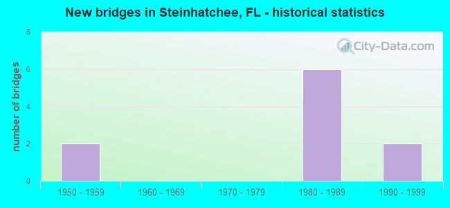
- New bridges - historical statistics
- 21950-1959
- 61980-1989
- 21990-1999


- Bridge Condition - Deck
- 75.0%Good
- 12.5%Satisfactory
- 12.5%Fair

- Bridge Condition - Superstructure
- 62.5%Good
- 25.0%Satisfactory
- 12.5%Fair

- Bridge Condition - Substructure
- 25.0%Good
- 25.0%Satisfactory
- 25.0%Fair
- 12.5%Poor
- 12.5%Imminent failure

- Bridge Condition - Channel
- 88.9%Good
- 11.1%Satisfactory
Find on map >> Show street view
Structure Number: 300001, Location: 4.8 MI WEST OF US 19 (Lat: 29.663972, Lng: -83.354639), Route carried "on" structure: County highway 358, Year Built: 1955, Status: Open, Structure Length: 0.77m (2.53ft), Average Daily Traffic: 950 (year 2020), Truck Traffic: 17%, Average Future Daily Traffic: 1,648 (year 2042), Design Load: HS 20, Features Intersected: PINE LOG BASIN
Minimum Vertical Clearance: 30+ m (98+ ft), Kilometerpoint: 2.705, Lanes on structure: 2, Owner: County Highway Agency, Approaching Roadway Width: 7.2m (23.6ft), Material/Design: Concrete, Design/Construction: Culvert, Number Of Spans In Main Unit: 3, Length of Maximum Span: 2.7m (8.9ft)
Condition: Channel: Satisfactory, Culverts: Good, Operating Rating: 37.6 metric tons, Method Used To Determine Operating Rating: Load Factor (LF), Inventory Rating: 22.6 metric tons, Method Used To Determine Inventory Rating: Load Factor (LF), Structural Evaluation: Equal to present minimum criteria, Waterway Adequacy: Equal to present desirable criteria, Approach Roadway Alignment: Equal to present desirable criteria, Designated Inspection Frequency: Every 24 months, Inspection Date: April 2020
Find on map >> Show street view
Structure Number: 300013, Location: 3.5 MI SOUTHWEST OF US 19 (Lat: 29.676944, Lng: -83.340833), Route carried "on" structure: County highway 358, Year Built: 1955, Status: Posted for load, Structure Length: 2.29m (7.51ft), Average Daily Traffic: 950 (year 2020), Truck Traffic: 15%, Average Future Daily Traffic: 1,648 (year 2042), Design Load: H 15, Features Intersected: SAND HILL CREEK
Minimum Vertical Clearance: 30+ m (98+ ft), Kilometerpoint: 4.772, Lanes on structure: 2, Owner: County Highway Agency, Approaching Roadway Width: 7.3m (24.0ft), Material/Design: Concrete, Design/Construction: Slab, Number Of Spans In Main Unit: 5, Length of Maximum Span: 4.6m (15.1ft), Curb or Sidewalk Widths: Left: 0.2m (0.7ft), Right: 0.2m (0.7ft), Curb-To-Curb Width: 6.1m (20.0ft), Out-to-Out Width: 6.6m (21.7ft)
Condition: Deck: Satisfactory, Superstructure: Satisfactory, Substructure: Satisfactory, Channel: Good, Operating Rating: 26.1 metric tons, Method Used To Determine Operating Rating: Load Factor (LF), Inventory Rating: 15.7 metric tons, Method Used To Determine Inventory Rating: Load Factor (LF), Structural Evaluation: Meets minimum limits, Deck Geometry: High priority of corrective action, Waterway Adequacy: Equal to present desirable criteria, Approach Roadway Alignment: Equal to present desirable criteria, Bridge Posting: Required (Relationship of Operating Rating to Maximum Legal Load: 30.0 - 39.9% below), Length Of Structure Improvement: 3.10m (10.17ft), Designated Inspection Frequency: Every 24 months, Underwater Inspection Frequency: Every 24 months, Other Special Inspection Frequency: Every 12 months, Inspection Date: April 2020, Underwater Inspection Date: April 2020, Other Special Inspection Date: April 2021, Bridge Improvement Cost: $291,000, Roadway Improvement Cost: $30,000, Total Project Cost: $437,000, Deck Structure Type: Concrete Cast-file-Place, Wearing Surface/Protective System: Wearing Surface: Bituminous
Find on map >> Show street view
Structure Number: 380087, Location: 0.1 MILE NORTH OF CR 358 (Lat: 29.667917, Lng: -83.378333), Route carried "on" structure: County highway 361, Year Built: 1982, Status: Open, Structure Length: 21.73m (71.29ft), Average Daily Traffic: 2,300 (year 2020), Truck Traffic: 1%, Average Future Daily Traffic: 3,990 (year 2042), Design Load: HS 20, Features Intersected: STEINHATCHEE RIV/RIVERSI, Facility Carried by Structure: 10TH STREET
Minimum Vertical Clearance: 30+ m (98+ ft), Kilometerpoint: 0.000, Lanes on structure: 2, Lanes under structure: 2, Owner: County Highway Agency, Approaching Roadway Width: 8.5m (27.9ft), Skew: 9 degrees, Navigation Control: Yes ( Vertical Clearance: 7.6m (24.9ft), Horizontal Clearance: 13.7m (44.9ft)), Material/Design: Prestressed concrete, Design/Construction: Stringer/Multi-beam, Number Of Spans In Main Unit: 12, Length of Maximum Span: 21.6m (70.9ft), Curb-To-Curb Width: 13.4m (44.0ft), Out-to-Out Width: 14.3m (46.9ft)
Condition: Deck: Good, Superstructure: Good, Substructure: Satisfactory, Channel: Good, Operating Rating: 52.6 metric tons, Method Used To Determine Operating Rating: Load and Resistance Factor (LRFR), Inventory Rating: 37.6 metric tons, Method Used To Determine Inventory Rating: Load and Resistance Factor (LRFR), Structural Evaluation: Equal to present minimum criteria, Deck Geometry: Better than present minimum criteria, Underclear: Superior to present desirable criteria, Waterway Adequacy: Equal to present desirable criteria, Approach Roadway Alignment: Equal to present desirable criteria, Designated Inspection Frequency: Every 24 months, Underwater Inspection Frequency: Every 24 months, Inspection Date: March 2020, Underwater Inspection Date: March 2020, Deck Structure Type: Concrete Cast-file-Place
Find on map >> Show street view
Structure Number: 380089, Location: 3.8 MI. S. OF US-19 (Lat: 29.733311, Lng: -83.359133), Route carried "on" structure: State highway 51, Year Built: 1984, Status: Open, Structure Length: 5.33m (17.49ft), Average Daily Traffic: 850 (year 2020), Truck Traffic: 9%, Average Future Daily Traffic: 1,475 (year 2042), Design Load: HS 20, Features Intersected: BOGGY CREEK
Minimum Vertical Clearance: 30+ m (98+ ft), Kilometerpoint: 10.335, Lanes on structure: 2, Base Highway Network: Yes, Owner: State Highway Agency, Approaching Roadway Width: 10.3m (33.8ft), Skew: 3 degrees, Material/Design: Concrete continuous, Design/Construction: Slab, Number Of Spans In Main Unit: 5, Length of Maximum Span: 11.0m (36.1ft), Curb-To-Curb Width: 12.2m (40.0ft), Out-to-Out Width: 13.0m (42.7ft)
Condition: Deck: Good, Superstructure: Good, Substructure: Good, Channel: Good, Operating Rating: 63.5 metric tons, Method Used To Determine Operating Rating: Load Factor (LF), Inventory Rating: 38.1 metric tons, Method Used To Determine Inventory Rating: Load Factor (LF), Structural Evaluation: Better than present minimum criteria, Deck Geometry: Equal to present desirable criteria, Waterway Adequacy: Equal to present desirable criteria, Approach Roadway Alignment: Equal to present desirable criteria, Designated Inspection Frequency: Every 24 months, Inspection Date: June 2020, Deck Structure Type: Concrete Cast-file-Place
Find on map >> Show street view
Structure Number: 380091, Location: IN STEINHATCHEE (Lat: 29.670361, Lng: -83.382178), Route carried "on" structure: State highway 51, Year Built: 1984, Status: Open, Structure Length: 2.93m (9.61ft), Average Daily Traffic: 850 (year 2020), Truck Traffic: 9%, Average Future Daily Traffic: 1,475 (year 2042), Design Load: HS 20, Features Intersected: LITTLE TIDE CREEK
Minimum Vertical Clearance: 30+ m (98+ ft), Kilometerpoint: 1.403, Lanes on structure: 2, Base Highway Network: Yes, Owner: State Highway Agency, Approaching Roadway Width: 6.4m (21.0ft), Skew: 1 degrees, Material/Design: Concrete continuous, Design/Construction: Slab, Number Of Spans In Main Unit: 3, Length of Maximum Span: 10.4m (34.1ft), Curb-To-Curb Width: 10.1m (33.1ft), Out-to-Out Width: 10.9m (35.8ft)
Condition: Deck: Good, Superstructure: Good, Substructure: Good, Channel: Good, Operating Rating: 65.1 metric tons, Method Used To Determine Operating Rating: Load Factor (LF), Inventory Rating: 39.1 metric tons, Method Used To Determine Inventory Rating: Load Factor (LF), Structural Evaluation: Better than present minimum criteria, Deck Geometry: Equal to present minimum criteria, Waterway Adequacy: Equal to present desirable criteria, Approach Roadway Alignment: Better than present minimum criteria, Designated Inspection Frequency: Every 24 months, Inspection Date: June 2020, Deck Structure Type: Concrete Cast-file-Place
Find on map >> Show street view
Structure Number: 384094, Location: 0.2 MI E OF SR 51 (Lat: 29.697833, Lng: -83.353333), Route carried "on" structure: County highway , Year Built: 1987, Status: Posted for load, Structure Length: 2.29m (7.51ft), Average Daily Traffic: 51 (year 2020), Average Future Daily Traffic: 88 (year 2042), Features Intersected: CEMETERY RUN, Facility Carried by Structure: RIVER AVENUE
Minimum Vertical Clearance: 30+ m (98+ ft), Kilometerpoint: 0.000, Lanes on structure: 1, Owner: County Highway Agency, Approaching Roadway Width: 4.0m (13.1ft), Material/Design: Concrete, Design/Construction: Slab, Number Of Spans In Main Unit: 5, Length of Maximum Span: 4.6m (15.1ft), Curb or Sidewalk Widths: Left: 0.2m (0.7ft), Right: 0.2m (0.7ft), Curb-To-Curb Width: 4.6m (15.1ft), Out-to-Out Width: 4.9m (16.1ft)
Condition: Deck: Fair, Superstructure: Fair, Substructure: Poor, Channel: Good, Operating Rating: 15.3 metric tons, Method Used To Determine Operating Rating: Load and Resistance Factor (LRFR), Inventory Rating: 12.1 metric tons, Method Used To Determine Inventory Rating: Load and Resistance Factor (LRFR), Structural Evaluation: Meets minimum limits, Deck Geometry: Better than present minimum criteria, Waterway Adequacy: Better than present minimum criteria, Approach Roadway Alignment: Somewhat better than minimum adequacy, Bridge Posting: Required (Relationship of Operating Rating to Maximum Legal Load: > 39.9% below), Length Of Structure Improvement: 2.29m (7.51ft), Designated Inspection Frequency: Every 24 months, Underwater Inspection Frequency: Every 12 months, Other Special Inspection Frequency: Every 12 months, Inspection Date: March 2020, Underwater Inspection Date: March 2021, Other Special Inspection Date: March 2021, Bridge Improvement Cost: $149,000, Roadway Improvement Cost: $15,000, Total Project Cost: $223,000, Deck Structure Type: Concrete Precast Panels
Find on map >> Show street view
Structure Number: 384096, Location: 0.5 MI E OF SR 51 VIA 2ND (Lat: 29.666667, Lng: -83.367500), Route carried "on" structure: County highway , Year Built: 1989, Status: Closed, Structure Length: 0.88m (2.89ft), Average Daily Traffic: 41 (year 2020), Average Future Daily Traffic: 71 (year 2042), Design Load: HS 20, Features Intersected: STEINHATCHEE RIVER, Facility Carried by Structure: GRANGER DRIVE
Minimum Vertical Clearance: 30+ m (98+ ft), Kilometerpoint: 0.000, Lanes on structure: 1, Owner: County Highway Agency, Approaching Roadway Width: 4.0m (13.1ft), Material/Design: Wood or Timber, Design/Construction: Stringer/Multi-beam, Number Of Spans In Main Unit: 2, Length of Maximum Span: 4.7m (15.4ft), Curb-To-Curb Width: 4.6m (15.1ft), Out-to-Out Width: 4.9m (16.1ft)
Condition: Deck: Good, Superstructure: Satisfactory, Substructure: Imminent failure, Channel: Good, Operating Rating: 18.4 metric tons, Method Used To Determine Operating Rating: Allowable Stress (AS), Inventory Rating: 13.8 metric tons, Method Used To Determine Inventory Rating: Allowable Stress (AS), Deck Geometry: Better than present minimum criteria, Waterway Adequacy: Better than present minimum criteria, Approach Roadway Alignment: High priority of replacement, Bridge Posting: Required (Relationship of Operating Rating to Maximum Legal Load: 30.0 - 39.9% below), Length Of Structure Improvement: 1.49m (4.89ft), Designated Inspection Frequency: Every 24 months, Other Special Inspection Frequency: Every 6 months, Inspection Date: January 2022, Other Special Inspection Date: January 2022, Bridge Improvement Cost: $152,000, Roadway Improvement Cost: $15,000, Total Project Cost: $228,000, Deck Structure Type: Wood or Timber
Find on map >> Show street view
Structure Number: 384098, Location: 0.1 MI EAST OF PALM ST (Lat: 29.696361, Lng: -83.351083), Route carried "on" structure: County highway , Year Built: 1997, Status: Posted for load, Structure Length: 1.82m (5.97ft), Average Daily Traffic: 11 (year 2020), Average Future Daily Traffic: 19 (year 2042), Features Intersected: STEINHATCHEE RIVER, Facility Carried by Structure: JR HOWELL RD
Minimum Vertical Clearance: 30+ m (98+ ft), Kilometerpoint: 0.000, Lanes on structure: 1, Owner: County Highway Agency, Approaching Roadway Width: 4.0m (13.1ft), Material/Design: Wood or Timber, Design/Construction: Stringer/Multi-beam, Number Of Spans In Main Unit: 4, Length of Maximum Span: 4.7m (15.4ft), Curb or Sidewalk Widths: Left: 0.1m (0.3ft), Right: 0.1m (0.3ft), Curb-To-Curb Width: 4.0m (13.1ft), Out-to-Out Width: 4.3m (14.1ft)
Condition: Deck: Good, Superstructure: Good, Substructure: Fair, Channel: Good, Operating Rating: 19.4 metric tons, Method Used To Determine Operating Rating: Load and Resistance Factor (LRFR), Inventory Rating: 15.0 metric tons, Method Used To Determine Inventory Rating: Load and Resistance Factor (LRFR), Structural Evaluation: Meets minimum limits, Deck Geometry: Somewhat better than minimum adequacy, Waterway Adequacy: Better than present minimum criteria, Approach Roadway Alignment: Somewhat better than minimum adequacy, Bridge Posting: Required (Relationship of Operating Rating to Maximum Legal Load: 20.0 - 29.9% below), Designated Inspection Frequency: Every 24 months, Underwater Inspection Frequency: Every 24 months, Inspection Date: March 2020, Underwater Inspection Date: March 2020, Deck Structure Type: Wood or Timber
Find on map >> Show street view
Structure Number: 384099, Location: 0.15 MI EAST OF PALM ST (Lat: 29.695889, Lng: -83.350750), Route carried "on" structure: County highway , Year Built: 1997, Status: Posted for load, Structure Length: 2.24m (7.35ft), Average Daily Traffic: 11 (year 2020), Average Future Daily Traffic: 19 (year 2042), Features Intersected: STEINHATCHEE RIVER, Facility Carried by Structure: JR HOWELL ROAD
Minimum Vertical Clearance: 30+ m (98+ ft), Kilometerpoint: 0.000, Lanes on structure: 1, Owner: County Highway Agency, Approaching Roadway Width: 4.0m (13.1ft), Material/Design: Wood or Timber, Design/Construction: Stringer/Multi-beam, Number Of Spans In Main Unit: 5, Length of Maximum Span: 4.6m (15.1ft), Curb or Sidewalk Widths: Left: 0.1m (0.3ft), Right: 0.1m (0.3ft), Curb-To-Curb Width: 4.0m (13.1ft), Out-to-Out Width: 4.3m (14.1ft)
Condition: Deck: Good, Superstructure: Good, Substructure: Fair, Channel: Good, Operating Rating: 19.8 metric tons, Method Used To Determine Operating Rating: Load and Resistance Factor (LRFR), Inventory Rating: 15.2 metric tons, Method Used To Determine Inventory Rating: Load and Resistance Factor (LRFR), Structural Evaluation: Meets minimum limits, Deck Geometry: Somewhat better than minimum adequacy, Waterway Adequacy: Better than present minimum criteria, Approach Roadway Alignment: Somewhat better than minimum adequacy, Bridge Posting: Required (Relationship of Operating Rating to Maximum Legal Load: 20.0 - 29.9% below), Designated Inspection Frequency: Every 24 months, Underwater Inspection Frequency: Every 24 months, Inspection Date: March 2020, Underwater Inspection Date: March 2020, Deck Structure Type: Wood or Timber
Find on map >> Show street view
Structure Number: 380087, Location: 0.1 MILE NORTH OF CR 358 (Lat: 29.667917, Lng: -83.378333), Route carried "under" structure: County highway , Year Built: 1982, Structure Length: 0. m, Average Daily Traffic: 650 (year 2018), Truck Traffic: 7%, Features Intersected: STEINHATCHEE RIV/RIVERSI, Facility Carried by Structure: 10TH STREET
Minimum Vertical Clearance: 5.12m (16.80ft), Kilometerpoint: 1.838, Lanes on structure: 2, Lanes under structure: 2, Material/Design: Prestressed concrete, Design/Construction: Stringer/Multi-beam, Length of Maximum Span: 21.6m (70.9ft)