Bridge Statistics for Steelton, Pennsylvania (PA)
Condition, Traffic, Stress, Structural Evaluation, Project Costs
- National Bridge Inventory (NBI) Statistics
- 12Number of bridges
- 1,214ft / 370mTotal length
- $38,000Total costs
- 149,353Total average daily traffic
- 24,436Total average daily truck traffic
- National Bridge Inventory (NBI) Registered Bridges for Steelton
- No street view available for this location
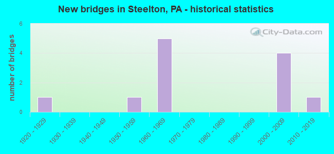
- New bridges - historical statistics
- 11920-1929
- 11950-1959
- 51960-1969
- 42000-2009
- 12010-2019


- Bridge Condition - Deck
- 50.0%Good
- 16.7%Satisfactory
- 33.3%Fair

- Bridge Condition - Superstructure
- 83.3%Good
- 16.7%Fair

- Bridge Condition - Substructure
- 16.7%Very good
- 50.0%Good
- 16.7%Satisfactory
- 16.7%Fair

- Bridge Condition - Channel
- 40.0%Very good
- 20.0%Good
- 40.0%Satisfactory
Find on map >> Show street view
Structure Number: 1434, Location: 1 MI.N. OF HIGHSPIRE (Lat: 40.226042, Lng: -76.792328), Route carried "on" structure: Interstate 283, Year Built: 1969, Status: Open, Structure Length: 1.28m (4.20ft), Average Daily Traffic: 24,714 (year 2021), Truck Traffic: 16%, Average Future Daily Traffic: 41,459 (year 2032), Design Load: HS 20, Features Intersected: SR 3002
Minimum Vertical Clearance: 30+ m (98+ ft), Kilometerpoint: 0.869, Lanes on structure: 2, Lanes under structure: 2, Base Highway Network: Yes, Owner: State Highway Agency, Approaching Roadway Width: 11.6m (38.1ft), Skew: 10 degrees, Material/Design: Prestressed concrete, Design/Construction: Box Beam or Girders - Single/Spread, Number Of Spans In Main Unit: 1, Length of Maximum Span: 12.8m (42.0ft), Curb or Sidewalk Widths: Left: 0.2m (0.7ft), Right: 0.2m (0.7ft), Curb-To-Curb Width: 12.2m (40.0ft), Out-to-Out Width: 13.0m (42.7ft)
Condition: Deck: Satisfactory, Superstructure: Good, Substructure: Good, Operating Rating: 52.6 metric tons, Method Used To Determine Operating Rating: Load Factor (LF), Inventory Rating: 30.8 metric tons, Method Used To Determine Inventory Rating: Load Factor (LF), Structural Evaluation: Better than present minimum criteria, Deck Geometry: Better than present minimum criteria, Underclear: Equal to present minimum criteria, Approach Roadway Alignment: Equal to present desirable criteria, Length Of Structure Improvement: 2.00m (6.56ft), Designated Inspection Frequency: Every 24 months, Inspection Date: October 2020, Deck Structure Type: Concrete Cast-file-Place, Wearing Surface/Protective System: Wearing Surface: Bituminous, Membrane: Preformed Fabric
Find on map >> Show street view
Structure Number: 14341, Location: 2 MI.N. HIGHSPIRE (Lat: 40.228158, Lng: -76.793656), Route carried "on" structure: Interstate 283, Year Built: 1969, Status: Open, Structure Length: 0.70m (2.30ft), Average Daily Traffic: 48,598 (year 2021), Truck Traffic: 17%, Average Future Daily Traffic: 79,446 (year 2032), Design Load: HS 20+Mod, Features Intersected: LAUREL RUN
Minimum Vertical Clearance: 30+ m (98+ ft), Kilometerpoint: 0.869, Lanes on structure: 4, Base Highway Network: Yes, Owner: State Highway Agency, Approaching Roadway Width: 35.4m (116.1ft), Skew: 24 degrees, Material/Design: Concrete, Design/Construction: Culvert, Number Of Spans In Main Unit: 1, Length of Maximum Span: 6.1m (20.0ft)
Condition: Channel: Good, Culverts: Satisfactory, Operating Rating: 49.0 metric tons, Method Used To Determine Operating Rating: Field evaluation and documented engineering judgment, Inventory Rating: 32.7 metric tons, Method Used To Determine Inventory Rating: Field evaluation and documented engineering judgment, Structural Evaluation: Equal to present minimum criteria, Waterway Adequacy: Superior to present desirable criteria, Approach Roadway Alignment: Equal to present desirable criteria, Length Of Structure Improvement: 1.20m (3.94ft), Designated Inspection Frequency: Every 24 months, Inspection Date: September 2020
Find on map >> Show street view
Structure Number: 14342, Location: 2 MI.N.HIGHSPIRE (Lat: 40.225992, Lng: -76.792572), Route carried "on" structure: Interstate 283, Year Built: 1969, Status: Open, Structure Length: 1.34m (4.40ft), Average Daily Traffic: 23,884 (year 2021), Truck Traffic: 17%, Average Future Daily Traffic: 37,987 (year 2032), Design Load: HS 20, Features Intersected: SR 3002
Minimum Vertical Clearance: 30+ m (98+ ft), Kilometerpoint: 0.867, Lanes on structure: 2, Lanes under structure: 2, Base Highway Network: Yes, Owner: State Highway Agency, Approaching Roadway Width: 11.6m (38.1ft), Skew: 10 degrees, Material/Design: Prestressed concrete, Design/Construction: Box Beam or Girders - Single/Spread, Number Of Spans In Main Unit: 1, Length of Maximum Span: 12.8m (42.0ft), Curb or Sidewalk Widths: Left: 0.2m (0.7ft), Right: 0.2m (0.7ft), Curb-To-Curb Width: 12.2m (40.0ft), Out-to-Out Width: 13.0m (42.7ft)
Condition: Deck: Fair, Superstructure: Good, Substructure: Satisfactory, Operating Rating: 52.6 metric tons, Method Used To Determine Operating Rating: Load Factor (LF), Inventory Rating: 30.8 metric tons, Method Used To Determine Inventory Rating: Load Factor (LF), Structural Evaluation: Equal to present minimum criteria, Deck Geometry: Better than present minimum criteria, Underclear: Better than present minimum criteria, Approach Roadway Alignment: Equal to present desirable criteria, Length Of Structure Improvement: 2.00m (6.56ft), Designated Inspection Frequency: Every 24 months, Inspection Date: October 2020, Deck Structure Type: Concrete Cast-file-Place, Wearing Surface/Protective System: Wearing Surface: Bituminous, Membrane: Preformed Fabric
Find on map >> Show street view
Structure Number: 14508, Location: 1 MI. N. OF HIGHSPIRE (Lat: 40.224719, Lng: -76.795167), Route carried "on" structure: State highway , Year Built: 1950, Status: Open, Structure Length: 0.85m (2.79ft), Average Daily Traffic: 9,905 (year 2022), Truck Traffic: 8%, Average Future Daily Traffic: 14,608 (year 2032), Design Load: H 20, Features Intersected: LAUREL RUN, Facility Carried by Structure: SR 3001
Minimum Vertical Clearance: 30+ m (98+ ft), Kilometerpoint: 1.088, Lanes on structure: 2, Owner: State Highway Agency, Approaching Roadway Width: 12.2m (40.0ft), Skew: 4 degrees, Material/Design: Concrete, Design/Construction: Culvert, Number Of Spans In Main Unit: 1, Length of Maximum Span: 8.5m (27.9ft)
Condition: Channel: Satisfactory, Culverts: Satisfactory, Operating Rating: 69.9 metric tons, Method Used To Determine Operating Rating: Allowable Stress (AS), Inventory Rating: 46.3 metric tons, Method Used To Determine Inventory Rating: Allowable Stress (AS), Structural Evaluation: Equal to present minimum criteria, Waterway Adequacy: Superior to present desirable criteria, Approach Roadway Alignment: Equal to present desirable criteria, Length Of Structure Improvement: 1.50m (4.92ft), Designated Inspection Frequency: Every 24 months, Inspection Date: October 2020
Find on map >> Show street view
Structure Number: 29568, Location: ALINDA (Lat: 40.346125, Lng: -77.285769), Route carried "on" structure: State highway 850, Year Built: 1929, Status: Open, Structure Length: 0.76m (2.49ft), Average Daily Traffic: 3,311 (year 2020), Truck Traffic: 10%, Average Future Daily Traffic: 5,359 (year 2032), Design Load: H 15, Features Intersected: BAKER CREEK
Minimum Vertical Clearance: 30+ m (98+ ft), Kilometerpoint: 23.448, Lanes on structure: 2, Base Highway Network: Yes, Owner: State Highway Agency, Approaching Roadway Width: 7.3m (24.0ft), Material/Design: Concrete, Design/Construction: Tee Beam, Number Of Spans In Main Unit: 1, Length of Maximum Span: 6.7m (22.0ft), Curb-To-Curb Width: 7.0m (23.0ft), Out-to-Out Width: 8.1m (26.6ft)
Condition: Deck: Fair, Superstructure: Fair, Substructure: Fair, Channel: Satisfactory, Operating Rating: 39.9 metric tons, Method Used To Determine Operating Rating: Load Factor (LF), Inventory Rating: 23.6 metric tons, Method Used To Determine Inventory Rating: Load Factor (LF), Structural Evaluation: Somewhat better than minimum adequacy, Deck Geometry: High priority of replacement, Waterway Adequacy: Equal to present minimum criteria, Approach Roadway Alignment: Equal to present desirable criteria, Length Of Structure Improvement: 1.50m (4.92ft), Designated Inspection Frequency: Every 24 months, Inspection Date: December 2020, Bridge Improvement Cost: $3,000, Roadway Improvement Cost: $8,000, Total Project Cost: $38,000, Deck Structure Type: Concrete Cast-file-Place, Wearing Surface/Protective System: Wearing Surface: Bituminous
Find on map >> Show street view
Structure Number: 45139, Location: FAIRVIEW TWP (Lat: 40.199556, Lng: -76.809931), Route carried "on" structure: Interstate 76, Year Built: 2007, Status: Open, Structure Length: 180.29m (591.50ft), Average Daily Traffic: 16,200 (year 2008), Truck Traffic: 21%, Average Future Daily Traffic: 25,980 (year 2030), Design Load: HS 25 or greater, Features Intersected: SUSQ R, AMT, SR0230.NSRR
Minimum Vertical Clearance: 10.45m (34.28ft), Kilometerpoint: 395.448, Lanes on structure: 3, Lanes under structure: 2, Base Highway Network: Yes, Toll: On toll road, Owner: State Toll Authority, Approaching Roadway Width: 18.0m (59.1ft), Skew: 10 degrees, Material/Design: Concrete continuous, Design/Construction: Segmental Box Girder, Number Of Spans In Main Unit: 40, Length of Maximum Span: 45.7m (149.9ft), Curb-To-Curb Width: 16.5m (54.1ft), Out-to-Out Width: 17.4m (57.1ft)
Condition: Deck: Good, Superstructure: Good, Substructure: Good, Channel: Very good, Operating Rating: 75.3 metric tons, Method Used To Determine Operating Rating: Load Factor (LF), Inventory Rating: 40.8 metric tons, Method Used To Determine Inventory Rating: Load Factor (LF), Structural Evaluation: Better than present minimum criteria, Deck Geometry: Equal to present minimum criteria, Underclear: Superior to present desirable criteria, Waterway Adequacy: Superior to present desirable criteria, Approach Roadway Alignment: Equal to present desirable criteria, Designated Inspection Frequency: Every 24 months, Underwater Inspection Frequency: Every 60 months, Inspection Date: May 2020, Underwater Inspection Date: October 2018, Deck Structure Type: Concrete Cast-file-Place, Wearing Surface/Protective System: Wearing Surface: Monolithic Concrete, Deck Protection: Epoxy Coated Reinforcing
Find on map >> Show street view
Structure Number: 45316, Location: FAIRVIEW TWP (Lat: 40.203333, Lng: -76.813333), Route carried "on" structure: Interstate 76, Year Built: 2007, Status: Open, Structure Length: 180.29m (591.50ft), Average Daily Traffic: 15,565 (year 2008), Truck Traffic: 21%, Average Future Daily Traffic: 22,020 (year 2030), Design Load: HS 25 or greater, Features Intersected: SUSQ R, AMT,SR230 NSRR,
Minimum Vertical Clearance: 10.45m (34.28ft), Kilometerpoint: 0.000, Lanes on structure: 3, Lanes under structure: 2, Base Highway Network: Yes, Toll: On toll road, Owner: State Toll Authority, Approaching Roadway Width: 18.0m (59.1ft), Skew: 10 degrees, Material/Design: Concrete continuous, Design/Construction: Segmental Box Girder, Number Of Spans In Main Unit: 40, Length of Maximum Span: 45.7m (149.9ft), Curb-To-Curb Width: 16.5m (54.1ft), Out-to-Out Width: 17.4m (57.1ft)
Condition: Deck: Good, Superstructure: Good, Substructure: Good, Channel: Very good, Operating Rating: 75.3 metric tons, Method Used To Determine Operating Rating: Load Factor (LF), Inventory Rating: 40.8 metric tons, Method Used To Determine Inventory Rating: Load Factor (LF), Structural Evaluation: Better than present minimum criteria, Deck Geometry: Equal to present minimum criteria, Underclear: Superior to present desirable criteria, Waterway Adequacy: Superior to present desirable criteria, Approach Roadway Alignment: Equal to present desirable criteria, Designated Inspection Frequency: Every 24 months, Underwater Inspection Frequency: Every 60 months, Inspection Date: May 2020, Underwater Inspection Date: October 2018, Deck Structure Type: Concrete Cast-file-Place, Wearing Surface/Protective System: Wearing Surface: Monolithic Concrete, Deck Protection: Epoxy Coated Reinforcing
Find on map >> Show street view
Structure Number: 48452, Location: SR 1005 (I-76 MM 244.9) (Lat: 40.196992, Lng: -76.822931), Route carried "on" structure: State highway , Year Built: 2013, Status: Open, Structure Length: 4.85m (15.91ft), Average Daily Traffic: 352 (year 2021), Truck Traffic: 8%, Average Future Daily Traffic: 638 (year 2030), Design Load: HL 93, Features Intersected: PA Turnpike (I-76), Facility Carried by Structure: SR 1005
Minimum Vertical Clearance: 30+ m (98+ ft), Kilometerpoint: 2.264, Lanes on structure: 2, Lanes under structure: 4, Owner: State Highway Agency, Approaching Roadway Width: 8.5m (27.9ft), Skew: 1 degrees, Material/Design: Prestressed concrete continuous, Design/Construction: Box Beam or Girders - Single/Spread, Number Of Spans In Main Unit: 2, Length of Maximum Span: 24.1m (79.1ft), Curb-To-Curb Width: 8.5m (27.9ft), Out-to-Out Width: 9.6m (31.5ft)
Condition: Deck: Good, Superstructure: Good, Substructure: Very good, Operating Rating: 56.1 metric tons, Method Used To Determine Operating Rating: Assigned ratings based on Load and Resistance Factor Design (LRFD) reported by rating factor (RF) using HL93 loadings, Inventory Rating: 35.3 metric tons, Method Used To Determine Inventory Rating: Assigned ratings based on Load and Resistance Factor Design (LRFD) reported by rating factor (RF) using HL93 loadings, Structural Evaluation: Better than present minimum criteria, Deck Geometry: Equal to present minimum criteria, Underclear: Superior to present desirable criteria, Approach Roadway Alignment: Meets minimum limits, Designated Inspection Frequency: Every 48 months, Inspection Date: October 2019, Deck Structure Type: Concrete Cast-file-Place, Wearing Surface/Protective System: Wearing Surface: Monolithic Concrete, Deck Protection: Epoxy Coated Reinforcing
Find on map >> Show street view
Structure Number: 1434, Location: 1 MI.N. OF HIGHSPIRE (Lat: 40.226042, Lng: -76.792328), Route carried "under" structure: State highway , Year Built: 1969, Structure Length: 0. m, Average Daily Traffic: 3,412 (year 2022), Truck Traffic: 5%, Features Intersected: SR 3002, Facility Carried by Structure: I-283 NB; SR 0283
Minimum Vertical Clearance: 4.57m (14.99ft), Kilometerpoint: 0.000, Lanes on structure: 2, Lanes under structure: 2, Material/Design: Prestressed concrete, Design/Construction: Box Beam or Girders - Single/Spread, Length of Maximum Span: 12.8m (42.0ft)
Find on map >> Show street view
Structure Number: 14342, Location: 2 MI.N.HIGHSPIRE (Lat: 40.225992, Lng: -76.792572), Route carried "under" structure: State highway , Year Built: 1969, Structure Length: 0. m, Average Daily Traffic: 3,412 (year 2022), Truck Traffic: 5%, Features Intersected: SR 3002, Facility Carried by Structure: I-283 SB; SR 0283
Minimum Vertical Clearance: 4.95m (16.24ft), Kilometerpoint: 0.000, Lanes on structure: 2, Lanes under structure: 2, Material/Design: Prestressed concrete, Design/Construction: Box Beam or Girders - Single/Spread, Length of Maximum Span: 12.8m (42.0ft)
Find on map >> Show street view
Structure Number: 45139, Location: FAIRVIEW TWP (Lat: 40.199556, Lng: -76.809931), Route carried "under" structure: Alternate State highway 76, Year Built: 2007, Structure Length: 0. m, Features Intersected: SUSQ R, AMT, SR0230.NSRR
Minimum Vertical Clearance: 7.90m (25.92ft), Kilometerpoint: 395.448, Lanes on structure: 3, Lanes under structure: 2, Toll: On toll road, Material/Design: Concrete continuous, Design/Construction: Segmental Box Girder, Length of Maximum Span: 45.7m (149.9ft)
Find on map >> Show street view
Structure Number: 45316, Location: FAIRVIEW TWP (Lat: 40.203333, Lng: -76.813333), Route carried "under" structure: State highway , Year Built: 2007, Structure Length: 0. m, Features Intersected: SUSQ R, AMT,SR230 NSRR,, Facility Carried by Structure: PA TURNPIKE (I-76)
Minimum Vertical Clearance: 8.57m (28.12ft), Kilometerpoint: 0.000, Lanes on structure: 3, Lanes under structure: 2, Toll: Toll bridge, Material/Design: Concrete continuous, Design/Construction: Segmental Box Girder, Length of Maximum Span: 45.7m (149.9ft)